FlyCart 30 on Dusty Coastlines: A Logistics
FlyCart 30 on Dusty Coastlines: A Logistics-Led Case Study in Better Aerial Capture
META: A field-driven FlyCart 30 case study on capturing dusty coastlines, with practical insight on payload ratio, winch workflow, dual-battery reliability, BVLOS planning, and how simple photo discipline improves results.
I spend most of my time thinking like a logistics lead, not a photographer. Routes, battery margins, weather windows, handoff points, payload security. That mindset changes how you look at a platform like the FlyCart 30.
Most people approach aerial image capture from the camera backward. They ask about lens quality, gimbal smoothness, or post-processing. On a dusty coastline, that is rarely where the real success or failure happens. The first battle is operational discipline. The second is aircraft capability. Only then does visual technique start to matter.
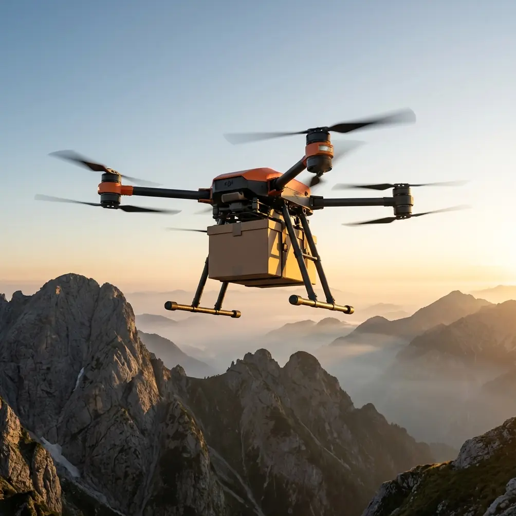
That is why the FlyCart 30 is an interesting aircraft for this scenario. Not because it is a pure camera drone. It isn’t. Its value shows up when the coastline is difficult, the landing zone is compromised by sand or loose debris, and the mission is bigger than grabbing a pretty hero shot. In those environments, the aircraft’s logistics DNA becomes an advantage over lighter, more image-centric competitors.
This article looks at FlyCart 30 through a case-study lens: capturing coastline conditions in dusty environments where transport capability, route stability, and minimal ground disturbance matter just as much as image composition.
The coastline problem most teams underestimate
Coastlines look simple from a distance. In practice, they are messy operating spaces.
You often have crosswinds rolling off open water, salt-heavy air, shifting visibility, and landing areas covered in fine dust or sand. Add cliffs, access roads, uneven staging zones, and teams trying to document erosion, inspect shoreline assets, or move light equipment between points. A conventional small drone can certainly fly there, but the workflow around it tends to become fragile.
The weak point is not always the aircraft’s flight performance. It is the overall mission chain.
If the drone needs a clean landing pad every cycle, that slows down field work. If payload flexibility is limited, you end up splitting one task into three trips. If battery management is tight, route optimization becomes reactive rather than planned. If the airframe is designed mainly for visual capture, it may not handle mixed logistics-and-documentation work efficiently.
That is where FlyCart 30 separates itself. Its core design priorities point toward transport and controlled delivery, which can be repurposed into a smarter coastal capture workflow.
Why a cargo drone matters for image work
This sounds counterintuitive until you’ve worked an exposed site.
A drone built around payload ratio and delivery stability can support visual operations in ways a traditional filming platform cannot. Along a dusty coastline, you may need to move sensors, markers, communication gear, or lightweight field kits to observation points before image collection even begins. A platform with a capable winch system changes that equation fast.
Instead of forcing landings in unstable, debris-prone areas, the aircraft can hold position and lower material where it is needed. Operationally, that matters for two reasons.
First, it reduces rotor wash interaction with sand and dust at the touchdown zone. Second, it keeps the aircraft out of marginal surfaces where loose material can complicate turnarounds.
For coastal capture teams, that means the drone is not just recording the site. It is enabling the site workflow.
Competitors that are stronger on pure cinema-style capture often struggle to match this kind of task flexibility. They may deliver cleaner out-of-the-box footage for a narrow purpose, but they do not necessarily perform better when the mission includes moving tools, deploying small assets, maintaining safe stand-off, and documenting terrain in one integrated operation.
A practical lesson from photography that applies directly to FlyCart 30 missions
A recent photography piece from chinahpsy outlined 8 simple shooting techniques that work for both smartphones and cameras. The most useful takeaway was not technical at all. The article specifically said you do not need to learn camera settings or memorize jargon to improve results. It also called out a common beginner error: trying to cram too many elements into one image, which makes the subject less noticeable and leaves the background cluttered.
That advice belongs in drone operations just as much as in photography.
When teams first capture coastlines, they often try to document everything at once: surf line, access road, cliff face, utility corridor, vegetation edge, team vehicles, and horizon. The result is a busy frame with weak informational value. The aircraft may be performing well, but the output is visually confused.
The better approach is disciplined subject isolation.
With FlyCart 30, that means defining the mission objective before launch. Are you documenting shoreline erosion? Verifying access conditions? Capturing dust impact near staging zones? Showing the relationship between a beach landing area and inland infrastructure? The frame should answer one question at a time.
This sounds basic, yet it changes sortie planning. Instead of broad, unfocused passes, the team can build route segments around specific visual goals. That makes BVLOS planning, battery budgeting, and payload transitions far cleaner.
Case study: documenting a dusty shoreline transfer corridor
Let’s take a realistic commercial scenario.
A coastal operations team needs to document a transfer corridor connecting an inland staging point to a narrow shoreline work zone. The site has two issues. First, the ground near the shoreline is dusty enough that repeated landings are undesirable. Second, the team wants both logistics support and visual records of terrain conditions over several days.
A smaller drone could capture footage. A utility-focused aircraft could move material. FlyCart 30 is notable because it can bridge both needs in one field system.
Phase 1: route definition
The team maps a corridor from the inland launch position to two shoreline points. Because this is a repeated mission, route optimization matters more than one impressive flight. Every unnecessary detour costs battery, time, and field focus.
This is where a logistics-oriented mindset helps. You are not only asking where the best shot is. You are asking:
- where the cleanest approach path is
- where the wind exposure increases
- where visual line continuity breaks
- where a stable hover for winch use is possible
- where dust disturbance is highest
That route-first logic is one of the strongest reasons to use FlyCart 30 in this environment. The aircraft’s mission architecture supports repeatable transport patterns rather than improvised flying.
Phase 2: no-touch delivery to protect the operating area
At the shoreline point, the team needs to drop a small field kit without landing. This is where the winch system becomes operationally significant, not just convenient.
On a dusty coast, avoiding touchdown is a serious advantage. Lowering the payload allows the aircraft to maintain a controlled hover while minimizing disturbance to the site surface. It also reduces the risk associated with uneven ground, scattered debris, or tight landing footprints.
Compared with competitors that require more direct landing interaction for delivery-style workflows, FlyCart 30 excels here because the aircraft is built around this use case rather than adapting to it as an afterthought.
Phase 3: visual capture with a narrower brief
Once the field kit is delivered, the same mission window is used to document the corridor. This is where the chinahpsy photography advice becomes practical. Do not overload the frame.
The team breaks the shoot into simple, isolated capture goals:
- shoreline access condition
- dust exposure around the transfer point
- cliff or embankment edge stability
- relation between staging zone and coastline
That disciplined framing produces more useful output than sweeping cinematic passes with too much visual information. The article’s point about clutter is exactly right. If everything is in the image, nothing stands out.
And because the guidance was framed as simple enough for smartphones and cameras, it also serves a useful reminder for drone teams: clear composition is not dependent on advanced settings knowledge. It is dependent on choosing the subject and excluding noise.
The FlyCart 30 advantage in harsh field rhythm
The reason this platform stands out on coastlines is not any single feature. It is the way multiple systems support continuity.
Dual-battery logic
On remote or repetitive shoreline runs, dual-battery architecture matters because it gives teams a more predictable energy model and stronger mission resilience. On a coast, conditions shift quickly. Return legs can become more demanding than outbound legs. A more robust power setup helps the pilot and operations lead think in terms of margin instead of hope.
That changes behavior. Teams with better energy confidence plan cleaner routes, make fewer rushed decisions, and preserve more room for contingencies.
Emergency parachute as a risk-management layer
Coastal environments do not forgive sloppy risk planning. With uneven access areas, wind changes, and water-adjacent operations, redundancy is not abstract. An emergency parachute is significant because it adds another layer to mission safety when operating in locations where ground recovery options may be limited.
For commercial users, that matters as much to project continuity as to safety compliance. Downtime on a shoreline job can ripple into weather delays, labor inefficiency, and missed inspection windows.
BVLOS relevance
The mention of BVLOS is not a buzzword here. In long, linear coastline work, it is often the operational shape of the mission. The route may follow a corridor rather than remain centered around one compact worksite. A platform that fits extended, structured route operations has a natural advantage over drones optimized for short-range visual creativity.
That is another reason FlyCart 30 can outperform some competitors in real field conditions. The comparison is not about who makes the prettier demo reel. It is about which system supports corridor-based commercial operations with fewer compromises.
Why “less in the frame” often means more business value
The chinahpsy article made a claim that simple techniques can improve keeper rate dramatically, even saying output success can rise by at least three times when people stop overcomplicating the process. You do not need to take that as a scientific benchmark to recognize the operational truth behind it.
On a worksite, better capture discipline creates better decisions.
If your frame isolates the actual erosion edge, the client sees the problem immediately. If your shot clearly shows dust accumulation at a transfer zone, maintenance planning becomes easier. If your images separate infrastructure from background clutter, reporting quality improves.
That is the hidden value of combining a capable logistics platform with simple visual rules. FlyCart 30 gives the field team more options in hard terrain. Basic composition discipline ensures those options produce usable evidence instead of noisy archives.
What I would tell a coastal team before deployment
As Alex Kim, wearing the logistics lead hat, my briefing would be straightforward.
Use FlyCart 30 because the coastline is an operational problem first and a visual problem second.
Build the route around repeatability. Use the winch system whenever the landing surface is likely to throw dust or compromise turnaround speed. Treat dual-battery capacity as a planning buffer, not an excuse to stretch margins. Keep BVLOS corridor logic tied to real objectives, not broad exploratory flying. And when it is time to capture visuals, do not try to fit the whole coastline into every frame.
Pick the subject. Remove the clutter. Let the aircraft’s transport-grade workflow carry the mission.
If your team is evaluating whether this setup fits a specific shoreline or industrial coastal corridor, it may help to talk through the mission profile first rather than starting with a spec sheet. For field planning questions, I’d point teams to this direct WhatsApp line: https://wa.me/85255379740
Final read on FlyCart 30 for dusty coastal capture
FlyCart 30 is not compelling here because it replaces every specialized camera drone. It is compelling because it solves the harder field equation.
On dusty coastlines, the winning platform is often the one that can avoid bad landings, support controlled delivery, maintain route discipline, and keep enough operational margin for repeated work. Add a simple but sharp visual philosophy—especially the reminder that beginners often ruin images by stuffing too much into the frame—and the mission output becomes much stronger.
That combination is where FlyCart 30 earns its place.
The aircraft’s strengths show up when the environment is inconvenient, the work has to repeat, and the mission includes more than image capture alone. In those conditions, competitors may be easier to categorize, but this model is easier to use productively.
Ready for your own FlyCart 30? Contact our team for expert consultation.