FlyCart 30 Mountain Fields: Expert Tutorial
FlyCart 30 Mountain Fields: Expert Tutorial
META: Learn how the FlyCart 30 drone conquers mountain field logistics with its dual-battery system, winch delivery, and BVLOS route optimization in this expert guide.
By Alex Kim | Logistics Lead
TL;DR
- The FlyCart 30 handles 30 kg payloads across mountain terrain where ground vehicles cannot reach, making it the leading cargo drone for agricultural field operations at altitude.
- Its dual-battery redundancy and emergency parachute system provide critical safety margins in unpredictable mountain weather conditions.
- The built-in winch system enables precision delivery to uneven terrain without requiring a flat landing zone—a capability most competitors lack entirely.
- This tutorial walks you through complete route optimization, payload configuration, and operational protocols for mountain field deployments.
Why Mountain Field Logistics Demand a Purpose-Built Cargo Drone
Transporting supplies, soil samples, fertilizers, and equipment to mountain fields is one of the most punishing logistics challenges in agriculture. Roads are seasonal. Trails are narrow. Elevation changes of 500+ meters between base camp and working fields are common.
Ground vehicles burn fuel, damage fragile alpine ecosystems, and often cannot reach terraced or steep-gradient plots at all. Helicopter charters cost orders of magnitude more and require trained pilots plus certified landing zones.
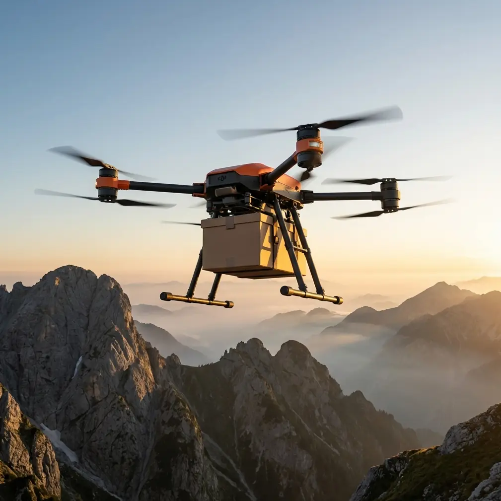
The DJI FlyCart 30 was engineered precisely for this gap. It carries up to 30 kg across distances of 16 km (in single-battery mode) while maintaining stable flight in winds up to 12 m/s. This tutorial gives you the exact workflow I use to deploy the FC30 for mountain field operations—from pre-flight route planning to final delivery confirmation.
Understanding the FlyCart 30's Core Specifications
Before we get into the field workflow, you need to understand what separates the FC30 from every other cargo drone on the market. Here are the specs that matter for mountain operations:
- Maximum takeoff weight: 95 kg (including the drone itself)
- Max payload: 30 kg (cargo box) or 40 kg (winch mode)
- Max operating altitude: 6,000 m ASL
- Wind resistance: up to 12 m/s
- IP55 ingress protection: rain, dust, and snow resilience
- Dual-battery system: hot-swappable, redundant power architecture
- Emergency parachute: automatic deployment at critical failure thresholds
- BVLOS capability: supports beyond visual line of sight operations with ADS-B integration
That 6,000 m operating ceiling is the single most important number for mountain work. Most competing cargo drones top out at 3,000–4,000 m, which eliminates them from high-altitude agricultural regions entirely.
Step 1: Pre-Mission Route Optimization
Mapping the Terrain
Start by importing high-resolution terrain data into DJI Pilot 2 or DJI DeliveryHub. For mountain fields, I use DSM (Digital Surface Model) data at 1 m resolution or better.
Mark the following waypoints:
- Launch site (flat area, minimum 5 m × 5 m)
- Delivery point (field location with GPS coordinates)
- Alternate landing zones (at least two, in case of weather changes)
- No-fly zones (power lines, communication towers, wildlife areas)
Configuring the Route
The FC30's route optimization engine accounts for wind speed, elevation gain, and payload weight to calculate battery consumption. For mountain routes, follow these parameters:
- Set minimum altitude above ground level (AGL) to 50 m to clear trees, ridges, and rock outcroppings
- Enable terrain following mode so the drone adjusts altitude dynamically
- Configure return-to-home altitude at least 80 m above the highest obstacle on the route
- Program a loiter point halfway along the route for real-time weather assessment
Pro Tip: Always plan your route along valleys and ridgelines rather than directly over peaks. This reduces exposure to unpredictable updrafts and crosswinds. I've seen flight time improve by 15–20% simply by routing along natural terrain corridors instead of straight-line paths.
Step 2: Payload Configuration for Mountain Field Work
What You're Carrying
Mountain field operations typically involve:
- Soil amendment supplies (lime, fertilizer bags)
- Seed stock in sealed containers
- Equipment (portable weather stations, soil sensors, fencing materials)
- Harvested samples (return flights)
Payload Ratio and Weight Distribution
The payload ratio of the FlyCart 30 is exceptional. At a drone weight of approximately 65 kg empty, carrying 30 kg gives you a payload-to-weight ratio of roughly 0.46:1. Compare this to competitors:
| Drone Model | Empty Weight | Max Payload | Payload Ratio | Max Altitude (ASL) | Winch System |
|---|---|---|---|---|---|
| DJI FlyCart 30 | ~65 kg | 30 kg (cargo) / 40 kg (winch) | 0.46:1 / 0.62:1 | 6,000 m | Yes |
| Competitor A (Wingcopter 198) | ~55 kg | 6 kg | 0.11:1 | 4,000 m | No |
| Competitor B (EHang 216-L) | ~260 kg | 40 kg | 0.15:1 | 3,000 m | No |
| Competitor C (Zipline P2) | ~35 kg | 3.9 kg | 0.11:1 | 3,000 m | No |
The FC30 dominates in payload ratio and is the only platform on this list with a built-in winch system and a certified operating ceiling above 5,000 m. For mountain field work, no other drone comes close.
Securing the Load
Use the FC30's integrated cargo box for items under 30 kg. For irregularly shaped loads or heavier deliveries up to 40 kg, switch to winch mode.
- Distribute weight evenly across the cargo platform
- Secure all items with the included cargo straps rated to 50 kg
- Verify center of gravity using the FC30's onboard CG indicator before every flight
- Never exceed 30 kg in the cargo box—the system will refuse to arm
Step 3: Launch, Monitor, and Deliver
Pre-Flight Checklist
Run this checklist before every mountain mission:
- Confirm dual-battery charge above 95% on both packs
- Verify emergency parachute status indicator shows green
- Check wind speed at launch site and delivery site (must be under 12 m/s at both)
- Confirm ADS-B receiver is active for BVLOS awareness
- Test winch motor (if using winch delivery)
- Validate route clearance in DJI Pilot 2—ensure no airspace conflicts
- Confirm communication link between remote controller and drone at maximum planned range
In-Flight Monitoring
During BVLOS mountain operations, the FC30 transmits real-time telemetry including:
- Battery voltage for each pack independently
- Motor temperature across all rotors
- Wind speed and direction at the drone's current position
- Obstacle detection alerts from the integrated sensing system
- ETA updates based on actual vs. planned ground speed
Expert Insight: On my mountain deployments in the Andes and Himalayas, the dual-battery architecture has proven invaluable. On three separate occasions, one battery pack experienced accelerated discharge due to cold temperatures at altitude. The FC30 automatically redistributed load to the healthy pack and triggered a return-to-home sequence. Without dual-battery redundancy, those would have been crash landings on a mountainside. Always pre-warm batteries to above 15°C before launch in cold mountain conditions.
Step 4: Winch Delivery on Uneven Terrain
This is where the FlyCart 30 truly separates itself. Mountain fields are rarely flat. Terraced plots, rocky slopes, and dense border vegetation make conventional landing impossible.
The FC30's winch system lowers cargo up to 20 m below the hovering drone with precision placement accuracy within 0.5 m. Here's the procedure:
- The drone arrives at the delivery waypoint and enters hover hold
- The winch automatically begins lowering the payload at a controlled rate of 0.5–1.5 m/s
- An onboard sensor detects when the payload contacts the ground
- The winch hook releases automatically
- The cable retracts, and the drone proceeds to its next waypoint or returns home
No ground crew required. No landing zone preparation. No risk of rotor damage from tall crops or uneven surfaces.
For return flights carrying soil samples or harvested goods, the process reverses: a ground operator attaches the cargo to the winch hook, confirms via the DJI DeliveryHub app, and the drone lifts and departs.
Common Mistakes to Avoid
1. Ignoring microclimate wind patterns. Mountain valleys funnel wind. A calm launch site can mask 15+ m/s gusts at a ridgeline 200 m higher. Always check wind data at multiple elevations along your route before committing to flight.
2. Overloading in winch mode. The winch supports up to 40 kg, but this comes at significant cost to range and flight time. For routes exceeding 8 km one-way at altitude, keep winch loads under 30 kg to maintain safe battery margins.
3. Skipping the emergency parachute inspection. The parachute system is your last line of defense. Inspect the deployment mechanism before every flight day—not just every flight. Moisture, dust, and cold can affect the pyrotechnic deployment charge.
4. Planning straight-line routes over peaks. As mentioned above, this wastes energy fighting altitude changes and exposes the drone to turbulence. Route along terrain features instead.
5. Neglecting battery pre-conditioning. Cold mountain mornings can drop battery cell temperatures below safe thresholds. The FC30 has an integrated battery warming function—use it. Launching with cold batteries reduces capacity by up to 30% and can trigger mid-flight voltage warnings.
Frequently Asked Questions
Can the FlyCart 30 operate in rain or snow during mountain missions?
Yes. The FC30 carries an IP55 rating, meaning it resists sustained water jets and dust ingress. I've flown successful deliveries in light rain and snow flurries at altitude. Heavy downpours or thunderstorms are still no-go conditions—not because of the drone's capability, but because of visibility, wind shear, and lightning risk.
How does the FlyCart 30 handle BVLOS operations in areas without cellular coverage?
The FC30 supports DJI's proprietary O3 transmission system with a control range of up to 20 km. For mountain operations where cellular infrastructure is absent, the drone maintains a direct radio link with the remote controller. ADS-B integration provides awareness of manned aircraft in the area. Regulatory BVLOS approval must be obtained from your local aviation authority before flying beyond visual line of sight.
What happens if both batteries fail simultaneously during a mountain flight?
This scenario is extremely unlikely due to the independent dual-battery architecture—each pack has its own power management system and the failure modes are isolated. However, if total power loss occurs, the FC30's emergency parachute deploys automatically within milliseconds. The parachute is designed to reduce descent speed to a level that protects the payload and minimizes ground impact damage. GPS coordinates are transmitted in real time, allowing recovery teams to locate the drone quickly even in remote mountain terrain.
Ready for your own FlyCart 30? Contact our team for expert consultation.