FlyCart 30 in Mountain Field Operations: The Altitude
FlyCart 30 in Mountain Field Operations: The Altitude, Route, and Winch Setup That Actually Works
META: A practical FlyCart 30 field guide for mountain operations, covering optimal flight altitude, route planning, winch use, payload strategy, dual-battery management, BVLOS considerations, and emergency safety setup.
Mountain field work exposes every weakness in a cargo drone plan. Wind rolls over ridgelines instead of behaving. GNSS quality changes as terrain walls close in. A route that looks clean on a map can become inefficient once elevation, approach angle, and lowering distance are factored in. If you are using a FlyCart 30 to move seed, tools, samples, irrigation parts, or survey gear into steep agricultural plots, the mission is not really about distance alone. It is about vertical logic.
I approach this as a logistics problem first. The aircraft matters, but what matters more is how you shape the mission around terrain. For mountain field capture and support runs, the most useful insight is this: the best flight altitude is usually not “as high as safely possible,” and it is not “terrain-hugging” either. The efficient band is typically a controlled offset above the local terrain profile that preserves signal confidence, keeps the route predictable, and reduces unnecessary climb-and-drop cycles.
For most mountain field transport missions with the FlyCart 30, that means planning around a relative height buffer rather than one fixed absolute altitude. In practice, I like operators to think in terms of staying roughly 30 to 60 meters above the controlling terrain along the active segment, then adjusting upward only where tree lines, rotor wash sensitivity, or ridge turbulence justify it. That range is not a magic rule. It is an operating mindset. It tends to balance three competing needs: obstacle margin, energy efficiency, and stable winch delivery geometry.
Why that matters becomes obvious once you break the mission into phases.
Start with the field, not the aircraft
When people say “capturing fields in mountain,” they often mean one of two things.
The first is data capture support: transporting batteries, RTK equipment, markers, or lightweight sensor kits to steep plots where a survey or crop assessment team is working.
The second is operational field servicing: moving fertilizers, irrigation fittings, repair parts, hand tools, or harvested samples between base and terrace.
In both cases, the mountain changes the job. A flatland route can be optimized mainly for distance. A mountain route has to be optimized for elevation transitions and safe delivery points. That is where FlyCart 30 workflow design becomes more valuable than headline specifications.
A common mistake is to set the route directly from launch point to field center and let altitude take care of itself. In mountains, that often forces repeated power-demand spikes as the aircraft crosses uneven contours. The better approach is to identify terrain shelves and route corridors that allow smoother vertical profiles. If the drone can hold a more consistent energy state, your payload ratio and battery planning improve immediately.
Payload ratio decides whether your route is smart
Mountain operators often obsess over maximum payload. I understand why. But payload ratio is the more useful metric.
By payload ratio, I mean the relationship between carried load and the energy cost of the full route profile, including climb, hover, lowering, and reserve. A mountain job with a moderate load can be less efficient than a heavier job on a gentler route if the aircraft spends too much time fighting elevation and wind.
This is one reason route optimization has to happen before loading decisions are finalized. If your route requires a steep ascent out of base, a cross-ridge transit, then a hover delivery over a narrow terrace, the practical load may need to be reduced to preserve margin. That is not underutilizing the aircraft. That is protecting schedule reliability.
The smart sequence is simple:
- Model the route with terrain and likely wind direction.
- Estimate the highest energy phase.
- Set the payload around that limiting phase, not the easiest part of the mission.
In mountain agriculture, this often means one of two operating styles. Either move smaller loads on highly repeatable cycles, or create a staging point at mid-elevation and divide one difficult route into two easier ones. FlyCart 30 missions become far more dependable when you stop treating every load as a point-to-point endurance test.
The best altitude for mountain field work
Let’s get specific.
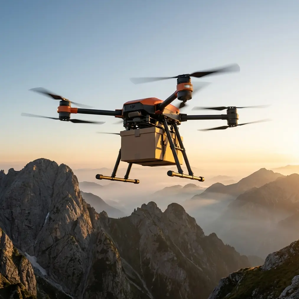
If your objective is to deliver into or support capture activity in mountain fields, the ideal cruising height is usually one that stays high enough to avoid local obstacles and low enough to avoid exaggerated exposure to ridge-top gusts. In many real civilian field missions, that puts the aircraft in a relative operating band of 30 to 60 meters above terrain, with short climbs above that where approach geometry demands it.
Here is why this works:
- Below that band, you risk more aggressive micro-terrain effects, tree interference, and route instability.
- Above that band, you can end up spending extra energy in windier air while also widening your approach footprint at the destination.
- Inside that band, the route is often easier to repeat consistently, which matters more than shaving a few seconds off a single run.
For the final approach into terraced or sloped plots, I prefer reducing forward speed early and letting the aircraft establish a stable hover offset from the drop point rather than descending directly into a cramped work zone. This is where the winch system earns its keep.
Why the winch system changes mountain delivery
In steep farm environments, landing is often the least elegant part of the mission. The ground may be uneven, muddy, obstructed by crop structures, or simply too narrow. That makes direct touchdown a poor habit.
A winch system allows the aircraft to remain in cleaner air above the field edge or terrace while the load is lowered into the usable zone. Operationally, that does three things:
- It reduces the need to commit the aircraft to unstable ground approaches.
- It lowers rotor wash impact on crops, soil, and loose materials.
- It makes repeat deliveries into the same point much easier to standardize.
That last point matters more than many teams realize. Standardization is what turns a drone from a one-off convenience into a dependable logistics asset. If the drop zone is always approached from the same side, at the same hover offset, with the same lowering profile, your time on station goes down and your safety margin usually goes up.
If you are building a mountain workflow around FlyCart 30, the winch should not be treated as an accessory feature. It should be part of the route architecture.
Dual-battery planning is not just about endurance
Operators hear “dual-battery” and think flight time. In mountains, dual-battery thinking should be more disciplined than that. The real value is mission resilience.
A route that looks acceptable on paper can become expensive if one segment requires repeated throttle response due to turbulence, or if the aircraft spends longer than expected stabilizing during a winch drop. Battery strategy has to account for that uncertainty. You are not planning for the average run. You are planning for the run that arrives with a headwind and a slightly longer hover than expected.
My recommendation is to establish battery go/no-go thresholds based on your most energy-intensive return scenario, not your outbound leg. Mountain operators get into trouble when the outbound trip feels easy because they are descending into the field, only to discover the return climb erases the comfortable margin they thought they had.
That is where disciplined route optimization and battery monitoring intersect. A dual-battery configuration gives you operational breathing room, but only if you respect the topography.
BVLOS only works when the route is boring
There is a paradox in advanced drone logistics. The better the route design, the less exciting the flight looks. That is exactly what you want.
For civilian mountain field operations, BVLOS planning should be built around repeatable corridors, known terrain clearances, consistent communication behavior, and predictable emergency options. If the route demands improvisation on every run, it is not mature enough for scaled operation.
The FlyCart 30 becomes much more effective when the route is “boring” in the best sense: same launch discipline, same transit corridor, same altitude logic, same destination geometry, same contingency actions.
I would strongly advise operators to map at least one alternate hold area and one alternate drop decision point for each mountain field route. If winds or field activity make the primary drop unsuitable, the mission should degrade gracefully. The aircraft should not be searching for solutions while airborne.
Emergency parachute logic in steep terrain
An emergency parachute is one of those systems people mention quickly and then fail to integrate into actual planning. In mountain work, that is a mistake.
The presence of an emergency parachute affects where you should be willing to fly and what your contingency map should look like. In terrain with terraces, tree bands, utility lines, and irrigation structures, not every area is equally acceptable as a last-resort descent zone. Operators should identify lower-risk sectors before the mission, not after an anomaly begins.
The significance is practical. Safety systems are only as useful as the terrain awareness behind them. A parachute is not permission to accept poor route design. It is the backstop for a route that was already responsibly structured.
A small lesson from outside drones
There is an unexpected parallel here from aviation design. A recent report in Chinese civil aviation media described EDID signing with Abu Dhabi operator RoyalJet to design cabin interiors for 3 Airbus ACJ320neo business jets. That new project was not a first encounter. It was built on two earlier successful collaborations in 2013 and 2016, and the new interiors are expected to incorporate Emirati cultural elements.
Why bring that up in a FlyCart 30 article?
Because good air operations rarely come from hardware alone. They come from adapting a platform to a specific operating environment and doing it with enough consistency that trust accumulates over time. In the RoyalJet case, the design work matters because the mission environment is culturally and operationally specific. In mountain drone logistics, the same principle applies. The route, drop method, altitude selection, and field workflow need to fit the place, not just the aircraft brochure.
That is also why mountain teams should keep a mission notebook. Track which terraces produce rotor wash issues. Record the altitude offsets that gave the cleanest path over each ridge. Note whether a north-facing corridor caused more battery draw in the afternoon. These details become operational culture. That is how performance improves.
A practical mountain mission template
Here is the setup I recommend for a FlyCart 30 supporting mountain field operations:
1. Build the route from terrain shelves
Do not draw a straight line first. Find the contour-friendly transit path first, then connect mission points.
2. Set a relative altitude band
Use a working cruise offset of about 30 to 60 meters above the controlling terrain where practical, then adjust only for local obstacles and wind behavior.
3. Use the winch to avoid poor landings
If the field edge is narrow or unstable, hold clear and lower the load. Standardize the hover point and lowering sequence.
4. Size payloads for the hardest segment
Base the load on the highest-energy phase, which is often the return climb, not the outbound leg.
5. Let dual-battery margin stay sacred
Do not spend reserve just because the outbound looked easy. Mountain conditions change faster than operators like to admit.
6. Prepare BVLOS routes that can be repeated
A route should be easy to describe and easy to audit. Complexity belongs in planning, not in live execution.
7. Tie emergency planning to geography
Know where a contingency descent creates the least downstream risk.
If your team is still tuning these mission variables, it helps to compare route sketches and field layouts with an experienced operator. I usually suggest teams share screenshots, elevation profiles, and intended drop geometry before they commit to a working SOP; if you need a quick operational review, this mountain route planning contact is an easy place to start.
What good looks like
A good FlyCart 30 mountain mission is not dramatic. It is quiet, repeatable, and slightly conservative. The aircraft leaves with a load that matches the route, climbs on a known corridor, cruises at an altitude that respects terrain without donating efficiency to unnecessary wind, arrives above a stable drop geometry, uses the winch cleanly, and returns with reserve intact.
That is the standard worth aiming for.
The temptation in mountain drone operations is to treat every successful flight as proof the plan was good. That is not always true. Sometimes the weather was simply forgiving. The stronger benchmark is whether the same mission could be repeated all week, by the same team, with the same margins, even as conditions shift.
That is where FlyCart 30 can become genuinely useful in mountain field support. Not because it can reach a hard place once, but because it can service that place reliably when the route, altitude, payload ratio, and safety systems are all working in the same logic.
Ready for your own FlyCart 30? Contact our team for expert consultation.