FlyCart 30 in High-Altitude Field Work: A Case Study
FlyCart 30 in High-Altitude Field Work: A Case Study in Seeing the Mission Before You Fly
META: A practical FlyCart 30 case study on high-altitude field operations, showing how framing, sightlines, and pre-flight visual discipline improve safety, route clarity, and load execution.
I lead logistics projects, not photo workshops. Still, one of the most useful lessons I’ve borrowed for FlyCart 30 field work came from a simple photography principle: bad results often come from basics, not from the equipment.
That applies to high-altitude agricultural and logistics flights more often than many teams admit.
When crews struggle to document a field properly, choose clean approach paths, or brief a delivery route across broken terrain, the first instinct is usually to blame visibility, weather, signal conditions, or the aircraft itself. In practice, the problem often starts earlier. The pilot or site lead did not really “read” the scene well enough before takeoff. They saw a field, but not the structure inside it. They saw open space, but not the visual traps hiding in the corners. They saw a destination, but not the best line leading the eye—and later the aircraft—toward it.
For FlyCart 30 operations in high-altitude fields, that matters.
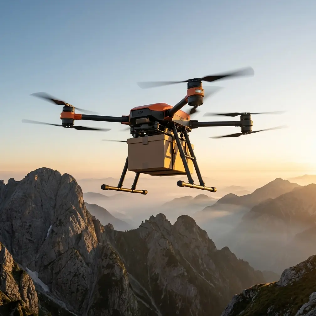
This aircraft is built for work: moving payloads, handling route demands, and supporting commercial missions where consistency matters more than spectacle. But field performance is never just about payload ratio, dual-battery architecture, a winch system, or BVLOS planning discipline in isolation. Those features only deliver their full value when the crew’s visual assessment is sharp. A messy site read creates a messy mission.
The day we stopped trusting “good enough”
A while back, my team was preparing a FlyCart 30 job in upland farmland where elevation and terrain shape made every decision feel tighter. The mission itself was straightforward on paper: repeated transport runs to support work across separated field zones. The complication was not only altitude. It was visual ambiguity.
At ground level, the area looked simple. From one angle, it seemed wide open. From another, shallow terraces, narrow access paths, fencing, and irregular vegetation started to change the reading. The launch zone felt usable. The drop area looked clear enough. That phrase—clear enough—is where small errors begin.
Before that operation, our pre-flight routine was technically complete. We checked power, system status, route assumptions, weather windows, landing options, and emergency provisions. We reviewed the emergency parachute protocol and battery readiness. We validated the delivery method and winch use parameters for the field. The checklist was not the issue.
What was missing was a more disciplined visual cleaning step.
I don’t mean cleaning the drone. I mean cleaning the frame.
The photography advice is simple: turn on the grid, avoid putting the subject dead center every time, adjust position slightly to create more space, use lines such as roads, rails, or gaps in foliage to guide attention, and scan the four corners before pressing the shutter so stray clutter does not sneak into the image.
That sounds unrelated to a logistics aircraft until you apply it to field reconnaissance.
Why composition matters in a FlyCart 30 mission
In high-altitude field work, the “subject” is not just the field. It is the operational path through the field.
When we began treating our site survey images and live visual review with more intention, the mission quality improved. We started using a grid-based mindset during reconnaissance. Not for aesthetics. For decision accuracy.
The source advice specifically recommends enabling a nine-grid overlay and placing the subject near an intersection instead of always pinning it in the middle. Operationally, that helps in two ways.
First, it forces the crew to see the surrounding space, not just the target point. A drop zone dead center in the frame can make everything around it disappear mentally. Edge hazards, slope transitions, line obstructions, and loose ground conditions become background noise. By shifting visual focus slightly off center, the eye starts registering approach width, exit space, and lateral risk more honestly.
Second, it improves route discussion inside the team. When the target area is framed with visible context instead of isolated in the middle, pilots and visual support staff can talk more precisely about entry direction, hover position, and winch deployment geometry.
That one adjustment changed how we briefed the FlyCart 30.
Instead of asking, “Can we reach the field edge?” we started asking, “What does the airspace around that field edge really look like from the intended approach direction?” Better question. Better mission.
The hidden value of moving a few steps
Another detail from the reference material says that shifting your shooting position slightly can make the composition feel more open and breathable. In field operations, this is not artistic language. It is practical risk control.
At high altitude, depth can be deceptive. Ground contours flatten visually. Distances lie. A launch area that looks comfortably separated from obstacles may reveal a very different geometry once the site lead moves a few meters left or right.
We made that a standard habit. Before finalizing our FlyCart 30 route plan, the survey lead would deliberately change position several times rather than documenting the site from the first acceptable viewpoint. Those small shifts often exposed things the original angle hid: a fence line aligned with the route, a narrowing corridor near the field edge, a rise in terrain that changed the apparent clearance margin, or a clump of vegetation close enough to affect rotor wash assumptions during delivery.
This matters especially when using a winch system. Winch-based delivery can reduce the need to put the aircraft directly into a tighter touchdown environment, but it does not remove the need for clean overhead positioning. If the site is misread because the reconnaissance angle was lazy, the precision advantage of the winch is undercut before the aircraft even lifts off.
That was one of our biggest takeaways. FlyCart 30 features reduce certain field constraints. They do not erase poor visual judgment.
Leading lines are not just for photographs
The same source points out that lines such as paths, railings, and even gaps through leaves can direct attention to the subject. In our case, the field had narrow access tracks and terrace edges that naturally drew the eye. Once we paid attention to them, they became useful planning cues.
A footpath across a field can suggest a human access route, but from an aerial operations perspective it can also reveal the cleanest visual corridor for understanding terrain segmentation. A fence line can expose directionality. A slanted stair or slope edge, as the source notes, can introduce a sense of motion in an image. For us, those diagonals often highlighted where the landscape itself was “pulling” the route, sometimes in a good way and sometimes in a dangerous one.
This became especially relevant in BVLOS-oriented planning discussions. Even when a mission is built around advanced route optimization and system confidence, crews still need a grounded mental model of the route environment. Lines in the landscape help build that model. They can reveal how a field connects to its access points, how the terrain channels movement, and where visual assumptions might become distorted.
A route that appears direct on the map may be poor in practice. A route that follows the logic already present in the land may provide better continuity, fewer surprises, and a clearer emergency decision path.
We did not invent that from software. We learned it by looking harder.
The four-corner scan that changed our safety brief
The most operationally useful detail from the source was also the simplest: before taking the shot, check the four corners of the frame and remove distractions such as bins or extra people.
In our environment, that became a formal pre-flight cleaning step for safety review.
Every site image, every launch-zone visual check, every target-zone reference frame got a four-corner scan. Not because we cared about neat photos, but because edges hide the things that later become incident reports.
A person standing just outside the main area of attention. A stack of loose material. A support vehicle nose creeping into the rotor influence area. A temporary marker that looked harmless until viewed from approach angle. A pole, wire, or branch that did not dominate the scene enough to command attention—but was still there.
The center of the image tells you what you want to do. The corners often tell you what can interfere with it.
That habit tightened our FlyCart 30 launch discipline. It also improved team communication. Once everyone knew the four-corner scan was part of the brief, discussions became less vague. People stopped saying “looks fine” and started saying “upper right edge has a possible obstruction,” or “bottom left includes foot traffic access.” Specific language improves operational decisions.
In high-altitude fields, where environmental margins can already be narrower, that specificity is not optional.
Where aircraft features enter the story
FlyCart 30 is often discussed through capability terms: payload handling, route efficiency, delivery flexibility, and protection features such as an emergency parachute. Those things matter. So does a dual-battery approach, because mission continuity and redundancy shape how confidently teams plan repeated transport cycles in demanding terrain.
But these strengths are best understood as force multipliers for disciplined operations, not substitutes for them.
Take the emergency parachute. It is part of a safety architecture, not an excuse to tolerate avoidable sloppiness in route selection or ground-zone management. Take route optimization. It can reduce wasted movement and help structure repeatability, but if the route was built on weak visual interpretation of the field, software efficiency simply executes a flawed plan more elegantly. The same goes for payload ratio discussions. A strong working platform only reaches its true operational value when launch, transit, hover, and delivery decisions are rooted in accurate field reading.
That is the practical link people miss. The aircraft can be highly capable and the mission can still be poorly seen.
A better way to brief high-altitude field capture and transport
If your FlyCart 30 team is working fields at elevation, here is the discipline I now recommend:
Start with reconnaissance images using a visible grid. The target area should not always sit dead center. Show context.
Then change position on purpose. One angle is never enough, especially in terrain with terraces, slopes, narrow paths, or vegetation breaks.
Next, identify natural leading lines in the environment. Paths, fence runs, terrace edges, and gaps in canopy can all help the team understand route logic and visual continuity.
Finally, perform a four-corner scan on every key visual reference used in the brief. Treat anything on the edges as operationally significant until ruled out.
That process takes very little time. It gives a lot back.
It sharpens route optimization discussions. It improves winch delivery confidence. It supports cleaner launch and recovery setup. It also helps the team think more clearly about contingency space, which is where emergency systems and disciplined planning actually meet.
If you are comparing field methods or want a second set of eyes on a FlyCart 30 workflow, you can message our operations desk here.
What this changed for us
After we built this visual cleaning step into our pre-flight process, our high-altitude field missions became less reactive. We spent less time correcting assumptions mid-operation. Our route briefs got shorter but more precise. Target zones were described with clearer spatial language. Winch deployments felt more predictable because we had done a better job reading overhead context before flight.
Most of all, the team stopped assuming that if the aircraft was ready, the mission was ready.
That is the real lesson.
A FlyCart 30 can bring serious utility to agricultural support, mountain-edge logistics, and field-linked transport work. Yet some of the biggest gains do not come from changing the airframe or adding another layer of technical complexity. They come from mastering ordinary visual discipline: how you frame the site, where you stand, what lines you notice, and whether you inspect the corners before you commit.
Basic does not mean trivial.
In high-altitude field work, the difference between a smooth operation and a compromised one is often visible before takeoff—if the crew knows how to look.
Ready for your own FlyCart 30? Contact our team for expert consultation.