FlyCart 30 in the Mountains: A Field Report on Why Better
FlyCart 30 in the Mountains: A Field Report on Why Better Results Don’t Start With Better Gear
META: A mountain field report on FlyCart 30 operations for forest capture missions, covering route planning, winch use, dual-battery endurance, BVLOS workflow, and why results depend on method more than equipment alone.
For people working around mountain forests, the temptation is familiar: when the footage, mapping output, or logistics run falls short, the first suspect is the aircraft. Not the route. Not the drop method. Not the timing. Not the pilot’s decisions. The machine.
That instinct is understandable, and it is not limited to drone crews. A recent personal reflection from a photographer captured the same pattern with unusual honesty. The writer described spending half a year photographing flowers, first with a phone, shooting casually because the blooms looked beautiful in person. The images came back cluttered, dull, and unable to reproduce what the eye had seen. The immediate conclusion was that the phone was the problem, that better equipment would surely create better pictures.
That is a useful starting point for a FlyCart 30 discussion, especially in mountain forest work.
Because the same mistake appears in cargo and remote imaging operations all the time.
A team heads into steep terrain to document forest corridors, move supplies to a ridge station, or support ecological work in an area where roads are unreliable. The mission struggles. Delivery points are inconsistent. Visual capture is mediocre. Flight time feels tighter than expected. Someone says the obvious thing: we need a bigger drone, a newer sensor, a different platform.
Sometimes that is true. Often, it is only partly true.
In mountain conditions, the quality of a FlyCart 30 operation is usually decided before takeoff.
The mountain doesn’t care how advanced your drone is
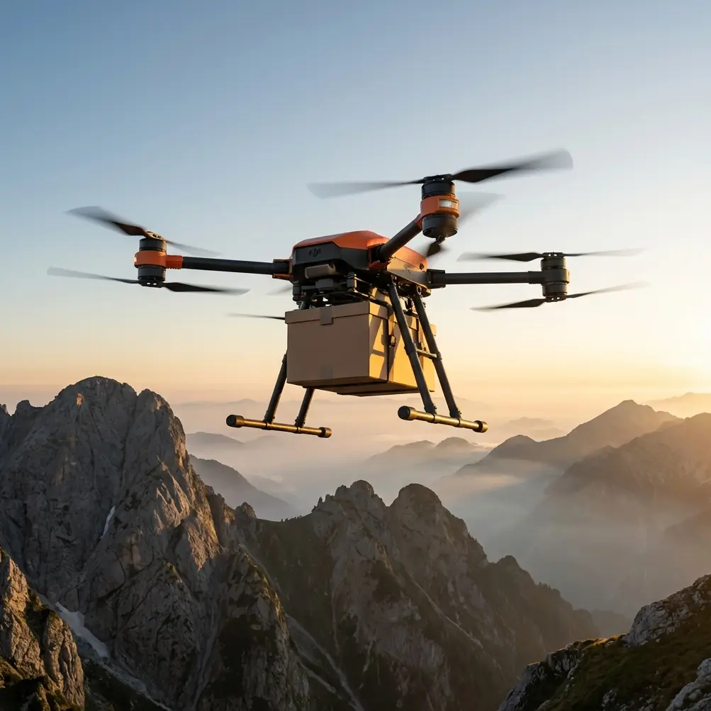
I have seen this repeatedly in forest logistics planning. On paper, the aircraft may be a strong match. The payload ratio is acceptable. The dual-battery configuration gives the team the operational confidence they need for altitude work. The emergency parachute supports risk management over broken terrain. The winch system makes vertical delivery possible without forcing a landing in a bad clearing.
Yet the mission still underperforms.
Why? Because mountain forests are less about raw hardware and more about disciplined task design. Dense canopy breaks sightlines. Ridge lift and downdrafts can change a stable corridor in minutes. Moist air near tree cover affects visibility and perception. Ground teams often choose receiving points for convenience rather than aerial suitability. And when people talk about “capturing forests in mountain,” they may be combining three separate goals without realizing it: visual documentation, route validation, and payload transfer.
That is where FlyCart 30 starts to make sense—not as a magic answer, but as a platform that rewards operational maturity.
What changed for our team
I’m writing this in the style of a field report because that is the only format that fits the reality.
Our assignment involved a mountain forest section with uneven ridgelines, a canopy that blocked easy landing options, and a need to capture usable visual material while also moving equipment to a higher observation point. The first planning draft looked efficient. It was not. We had chosen a route that made sense from the map view but not from the air. It crossed a narrow saddle that amplified wind shear and forced the aircraft into repeated micro-corrections. The result would have been exactly like that flower photographer’s first images: technically produced, but unable to recreate what mattered in the field.
So we rebuilt the mission around three things.
First, route optimization. Not the broad concept. The actual route. We stopped thinking in straight lines between departure and destination and started thinking in energy states, terrain shielding, and communication reliability. For mountain FlyCart 30 work, route optimization is not just about speed. It directly affects payload stability, battery margin, and the quality of the data you capture during transit. A route that is two minutes longer but avoids a turbulent ridge shoulder can produce cleaner flight behavior, more predictable winch deployment, and better imagery.
Second, drop logic instead of landing logic. This is where the winch system matters operationally. In forest missions, teams often waste time looking for a “good enough” landing patch. That mindset is inherited from smaller UAV habits or from ground vehicle thinking. In steep woodland, hovering over a controlled drop zone and lowering cargo with a winch is often the safer and more repeatable option. The significance is not convenience. It is reduction of exposure to rotor wash near branches, uneven surface contact, and uncertain recovery footing for the receiving team.
Third, battery planning as a safety tool, not just an endurance metric. The dual-battery setup matters because mountain work punishes optimistic planning. A dual-battery system gives you more than longer operational windows; it gives you decision space. That extra margin can be the difference between continuing a planned pass, holding for a clearing signal from the ground team, or abandoning a drop because wildlife enters the zone.
That last point became very real.
The wildlife moment that changed the mission tempo
We were approaching a forest-edge transfer point near a break in the canopy. The sensors had already been doing what they should do in mountain work: helping us read the immediate environment rather than assume it. As the aircraft came toward the planned release position, movement appeared at the edge of the trees. A small deer stepped into the opening, then another shape behind it. Not dramatic. Not dangerous. Just enough to make the original drop timing unacceptable.
This is the kind of thing that separates a clean operation from a careless one.
The aircraft’s sensing and obstacle-awareness behavior gave us time to hold position and reassess rather than press the plan. We delayed the descent profile, maintained hover, and adjusted the release timing after the animals moved clear of the area. That sounds minor until you remember what mountain forest operations actually involve: limited visibility from the ground, unstable footing for personnel, and a lot of pressure to “just finish the run.”
In civilian fieldwork, good sensors are not there to impress anyone. They are there to slow down bad decisions.
BVLOS matters, but only if the workflow around it is disciplined
A lot of FlyCart 30 interest centers on BVLOS potential, and for good reason. Mountain forests are exactly the sort of environment where beyond visual line of sight capability can expand operational reach. But the phrase is often treated too loosely.
BVLOS is not simply flying farther.
In forest logistics and capture missions, BVLOS becomes useful when paired with pre-validated routes, terrain-aware communication planning, clear lost-link procedures, and strong handoff discipline between mission lead and visual support personnel where required by local procedures. If you skip those elements, extended reach just enlarges your uncertainty.
For our operation, BVLOS-style route logic was valuable because the terrain repeatedly broke direct visual continuity. That meant mission confidence had to come from preparation, not from improvisation. Every leg was checked against canopy height variation, expected wind behavior, and drop contingencies. The result was a smoother mission not because the drone was “smarter” in the abstract, but because the workflow respected the environment.
That distinction is worth emphasizing for anyone researching FlyCart 30.
The platform may enable advanced operations. It does not replace field judgment.
Payload ratio is not a brochure term in mountain forestry
One of the more misunderstood planning factors in mountain work is payload ratio. People often treat it as a simple number: how much can the aircraft carry relative to what it weighs or how long it can stay airborne. In practice, payload ratio is a planning language for tradeoffs.
In a forest mountain scenario, increasing payload affects more than endurance. It can affect climb behavior near ridges, stability during directional changes, reserve margin for hold patterns, and the quality of any visual capture collected during the same sortie. If your mission combines documentation and transport, payload ratio becomes even more consequential. The heavier the carried load, the less forgiving the profile may be when you need to pause, reposition, or wait out environmental interference.
That is why many underperforming missions are not failures of equipment at all. They are failures of role definition.
Do you want the sortie to prioritize cargo certainty? Corridor recording? Terrain scouting? Drop-point validation? These can overlap, but not indefinitely. A professional FlyCart 30 operation in mountain forests works best when each flight has a dominant job, not five competing ones.
Why the “better gear” mindset leads teams astray
The flower photographer’s reflection is valuable because it exposes a common operational illusion. At first, the problem looked like bad hardware. In reality, the issue was undeveloped seeing.
Drone teams do the same thing in mountain environments. They assume disappointing results are caused by platform limits when the real problem may be:
- poor route design through unstable air,
- badly chosen handoff zones under canopy,
- overambitious payload planning,
- weak drop-zone discipline,
- or a mission objective that was never narrowed enough to execute cleanly.
FlyCart 30 is strong precisely because it can support structured work: cargo movement, remote area support, difficult terrain delivery, and managed operations where landing is the wrong answer. But that strength only shows up when the team stops expecting the aircraft to solve planning mistakes.
I would go further. In mountain forest use, the drone is often the least confused part of the mission.
Practical lessons from the field
If your use case involves capturing forests in mountain terrain with FlyCart 30 in the mix, a few lessons stand out.
1. Build around the receiving site, not the launch site
Most teams obsess over departure setup and underthink the endpoint. In forestry support work, the receiving zone determines whether the winch system becomes an advantage or a liability. Can the team below maintain a clear vertical line? Is the canopy opening wide enough? Is there room to delay release if animals or personnel move unexpectedly?
2. Use dual-battery margin to preserve decision quality
Battery redundancy and endurance are not there so you can stretch every mission to its limit. They are there so you can avoid rushed judgments. In our case, they gave us time to hold after the deer entered the drop area. That is operational significance, not marketing language.
3. Treat route optimization as image quality control too
Even when the primary task is delivery, a stable route improves captured material. Less abrupt correction means steadier visual output and better contextual data for later analysis of forest corridors, slope access, or canopy gaps.
4. Emergency systems belong in the planning conversation
The emergency parachute is easy to mention and easy to forget. In broken mountain terrain, it should influence route approval, especially over areas where ground recovery is difficult. Safety hardware is not an appendix. It changes what level of risk is acceptable.
5. Don’t confuse access with readiness
Yes, FlyCart 30 can open mountain routes that would be slow or impractical by ground. That does not mean every route is immediately suitable. Terrain access is one thing. Repeatable mission architecture is another.
The real value of FlyCart 30 in mountain forest work
If I had to reduce the platform’s value to one sentence, it would be this: FlyCart 30 is most impressive when it makes disciplined operations practical in places where careless operations would fail.
That is a very different claim from saying the aircraft alone produces success.
The better comparison is not with a less capable drone. It is with the earlier version of the team—the version that thinks technology can compensate for weak observation.
That is why the flower story lands. The photographer spent months believing a new device would create better images, only to discover that the missing ingredient was not the equipment itself. It was perception, selection, and intent.
Mountain UAV work teaches the same lesson, just with higher stakes.
When the route is properly optimized, the payload ratio is treated honestly, the winch system is used for what it is designed to do, and the dual-battery reserve is respected as a safety margin, FlyCart 30 becomes a serious tool for forest operations. Add well-managed BVLOS workflow and an emergency parachute into the risk model, and the aircraft starts fitting the mountain rather than fighting it.
If your team is evaluating a mountain forest workflow and wants to compare route logic, drop-zone setup, or mission architecture, you can message our field team here.
The main takeaway is simple. In the mountains, better outcomes rarely begin with asking for more gear. They begin with asking better questions of the gear you already chose.
Ready for your own FlyCart 30? Contact our team for expert consultation.