FlyCart 30 in Dusty Solar Farms: What New Drone Training
FlyCart 30 in Dusty Solar Farms: What New Drone Training Signals for Real-World Operations
META: A technical review of FlyCart 30 relevance for dusty solar farm missions, using new drone education developments in Xiamen and New Jersey to explain training, safety, altitude strategy, and operational readiness.
Anyone evaluating the FlyCart 30 for work around solar farms should pay attention to a story that, at first glance, does not look like product news at all. It is training news. And that is exactly why it matters.
Two recent education moves, one in Xiamen and one in New Jersey, point to the same shift in the UAV sector: aircraft capability is no longer the main bottleneck. Operational competence is. For FlyCart 30 users, especially teams working around dusty utility-scale solar sites, that distinction is practical, not academic.
In Xiamen, Jimei Industrial School reportedly spent the last two years adjusting its teaching direction to fit local low-altitude economy needs. The school is building what it describes as composite talent: people who can fly, understand theory, and apply drone tools in industry. The curriculum includes UAV aerial imaging and post-production as well as UAV aerial surveying and mapping. In New Jersey, Warren County Community College has launched a counter-drone security program designed to train both students and working professionals to identify, assess, and respond to drone threats.
Those are very different programs. One emphasizes applied drone operations tied to industry. The other focuses on airspace security and response. Taken together, they describe the real operating environment for a platform like the FlyCart 30. It is not enough to own a capable aircraft with a strong payload ratio, dual-battery architecture, and a winch system suited to precise delivery workflows. The value comes from whether the crew can interpret site conditions, maintain safe routing, and operate inside an increasingly managed airspace.
That matters a lot in solar farms.
Dust changes everything on site. It affects visibility near the surface, contaminates exposed components, and complicates landing and pickup workflows. Solar farms also create their own visual and thermal oddities. Long rows of reflective panels can distort depth cues, reduce contrast in harsh light, and make manual judgment less reliable when an operator is already juggling route optimization, load stability, and battery margins. If you are assessing the FlyCart 30 for this environment, the smarter question is not “Can it fly here?” It is “What kind of trained team gets the best result here without degrading safety?”
The Xiamen example is useful because it reflects a maturing view of drone work. A school did not simply add a piloting class. It adjusted direction over a two-year period and added industry application courses like aerial imaging, post-processing, and aerial surveying. Operationally, that tells us something important for FlyCart 30 deployments at solar farms: visual data and spatial data are becoming part of the same workflow as flight execution. On a dusty site, that blend matters.
A logistics lead planning FlyCart 30 missions over solar assets may not be using the aircraft as a camera platform in the classic sense, but the same visual literacy still counts. Dust plumes, glare off module surfaces, access-lane geometry, cable runs, inverter pads, fencing, and maintenance crew movement all shape route design. Teams trained to interpret imagery and mapping outputs are better equipped to set safer corridors, identify probable turbulence or dust pockets near the ground, and choose more reliable drop or hover points.
This is where optimal flight altitude becomes less of a rule and more of a site-specific discipline.
For dusty solar farms, a practical working altitude for FlyCart 30 transit legs is often best kept moderately above the surface disturbance layer rather than hugging the arrays. In many sites, that means using a higher cruise band over the rows and only descending when the aircraft is aligned with a clear delivery or inspection task window. A useful operational starting point is to stay around 20 to 30 meters above ground level for general movement across the farm, then descend deliberately only where the route and surface conditions have been verified.
Why this band? Too low, and the aircraft is more exposed to dust recirculation, localized gusting between infrastructure, and visual disruption from reflected sunlight. Too high, and you may give up precision, increase exposure to broader wind effects, and complicate obstacle awareness if the site includes poles, trackers, or temporary maintenance equipment. The best crews treat altitude as part of route optimization, not as a fixed preference. They preserve a buffer over the dirtiest layer, then use controlled descent with the winch system where possible to reduce touchdown disturbance.
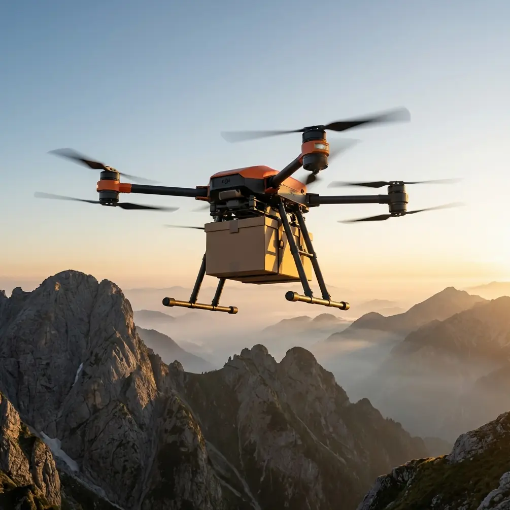
That last point is central to FlyCart 30 logic. In a dusty solar farm, a winch system is not just a convenience feature. It can be the cleaner option. Lowering cargo from a hover rather than forcing repeated ground contact helps reduce rotor wash interaction with loose surface material. It also limits the chance of debris ingestion around loading points. If your mission profile involves moving tools, sensors, small replacement parts, or urgent maintenance supplies across a large array field, the delivery method matters almost as much as payload capacity.
The dual-battery design also deserves attention in this context, not because it sounds reassuring in a brochure, but because solar farm work can be deceptively punishing. Distances on utility sites add up quickly. Hover time near task zones consumes energy differently than straightforward transit. Dust and heat can further complicate real endurance expectations. A dual-battery setup gives operators more resilience in planning, especially when they are balancing payload ratio against reserve policy and return margins. The right crew will not simply ask how much the aircraft can carry. They will ask what carrying that load does to safe outbound range, hover time over the target area, and recovery options if visibility drops or winds shift.
That is where the New Jersey security training story comes into sharper focus.
Counter-drone education may seem unrelated to solar farm operations, but it points to the professionalization of airspace awareness. A modern solar site is not just an isolated patch of land. It may sit near roads, substations, distribution infrastructure, or restricted operating practices imposed by owners and insurers. A program designed to train people to identify and respond to drone threats reflects a broader reality: more stakeholders are watching the sky, and more operators must justify how they fly.
For FlyCart 30 teams, this raises the bar on BVLOS thinking even when a mission remains within direct observation procedures. Route planning now intersects with security posture. Crews need to be able to distinguish normal site activity from suspicious drone presence, understand response protocols, and document their own operation clearly enough that it is recognized as legitimate. On critical infrastructure sites, this is no small matter. Solar farms increasingly resemble managed industrial assets, not open fields. Operators who can coordinate logistics and airspace discipline will have a real edge.
There is another operational lesson in the WCCC model: the program is not only for students. It is also for working professionals. That is exactly the audience FlyCart 30 programs should target internally. The best deployment model is rarely “buy aircraft, assign pilot, start missions.” It is “train the operating team around the mission.” For dusty solar farm work, that team includes not just the pilot in command, but maintenance personnel, visual observers where required, site coordinators, and anyone responsible for emergency procedures.
Emergency parachute readiness is a good example. On paper, it is a safety feature. In practice, it is only as valuable as the team’s response planning. If a platform triggers a parachute deployment over a solar site, where is the preferred descent zone? Which rows are treated as no-drop areas because of personnel density or sensitive equipment? Who secures the landing location? Who inspects recovered cargo for contamination from dust impact? These are training questions, not hardware questions.
That is why the Xiamen and New Jersey developments matter so much for FlyCart 30 readers. They show that the industry is moving toward specialization from two sides at once. One side is applied industrial utility: imaging, mapping, and practical field use. The other is controlled, security-aware operations: detecting threats, assessing intent, and responding correctly. A serious FlyCart 30 operator on a solar farm needs both instincts.
From a technical review perspective, that places the FlyCart 30 in an interesting position. Its relevance to solar farm logistics is less about raw spectacle and more about systems fit. The aircraft suits missions where payload movement needs to be precise, repeatable, and less dependent on rough terrain access. Dusty sites reward aircraft that can minimize unnecessary landings, maintain stable delivery profiles, and preserve enough power reserve for conservative decision-making. The platform’s utility increases when crews are capable of interpreting maps, adapting altitude bands, and handling edge cases without improvisation.
So what does a mature FlyCart 30 solar farm workflow look like?
It starts before takeoff. The team reviews panel row orientation, service road conditions, prevailing wind, and dust concentration zones. It sets a cruise altitude that avoids the worst surface disturbance layer, often in that 20 to 30 meter range, then defines descent points with clean approach geometry. Cargo loads are evaluated by payload ratio, not just absolute weight, because stability and reserve margins matter more than bragging rights. Winch delivery is preferred where it reduces rotor wash impact. Dual-battery planning is tied to real site legs, hover segments, and contingency return paths. Emergency parachute procedures are briefed against actual site map references, not generic checklists. And if the site has elevated security concerns, the crew documents flight intent clearly and coordinates with facility management before launch.
That is the difference between owning a capable UAV and running a dependable aerial logistics program.
If your team is building or refining that kind of operating model, it helps to compare notes with people who work these mission profiles every week. For field-specific planning questions, you can message our operations desk here and discuss route design or delivery setup in practical terms.
The larger takeaway from these education developments is simple. Drone operations around infrastructure are becoming more layered. Xiamen’s two-year teaching adjustment toward applied low-altitude industry skills shows the demand for operators who can do more than hold a controller. Warren County Community College’s security curriculum shows that airspace judgment is now a professional competency in its own right. For FlyCart 30 users in solar farm environments, those trends meet in one place: the mission plan.
Aircraft matter. Training matters more. Especially when the site is dusty, the terrain is repetitive, the work is time-sensitive, and every meter of altitude changes risk.
Ready for your own FlyCart 30? Contact our team for expert consultation.