FlyCart 30 Guide: Capturing Urban Vineyards Safely
FlyCart 30 Guide: Capturing Urban Vineyards Safely
META: Learn how to use the DJI FlyCart 30 for urban vineyard cargo delivery. Expert tutorial covers payload ratio, route optimization, BVLOS ops, and safety features.
By Alex Kim | Logistics Lead
Urban vineyard operations face a brutal logistics bottleneck: narrow streets, sensitive crops, and delivery windows measured in hours, not days. This tutorial walks you through exactly how to deploy the FlyCart 30 for vineyard cargo delivery in dense urban environments—from the pre-flight cleaning step most pilots skip to advanced BVLOS route optimization that slashes delivery cycles dramatically.
TL;DR
- The FlyCart 30 carries up to 30 kg with a dual-battery system that enables round-trip urban vineyard deliveries of up to 16 km per charge.
- Pre-flight cleaning of obstacle-avoidance sensors is a non-negotiable safety step that directly impacts emergency parachute reliability and flight stability.
- BVLOS route optimization through DJI DeliveryHub allows you to program repeatable corridors between distribution hubs and vineyard plots surrounded by buildings.
- The integrated winch system enables precision drops into tight vineyard rows without requiring a flat landing zone.
Why Urban Vineyards Are a Unique Drone Delivery Challenge
Urban vineyards are not rural farms. They sit wedged between apartment blocks, overhead power lines, and pedestrian zones. Traditional ground logistics means navigating one-way streets, parking restrictions, and time-sensitive biological cargo like rootstock, soil amendments, and harvested grape clusters.
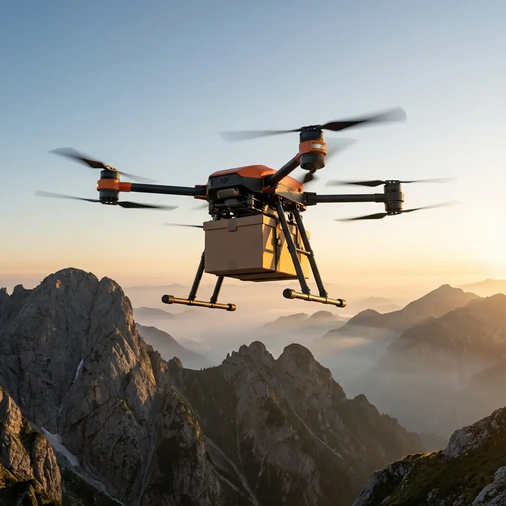
The FlyCart 30 was engineered for exactly this kind of constrained heavy-lift mission. Its payload ratio of roughly 1:1 (the airframe weighs approximately 30.5 kg and carries up to 30 kg) makes it one of the most efficient cargo drones available for short-range, high-frequency deliveries.
But efficiency means nothing if your operation isn't safe. That starts before you ever spin up the rotors.
The Pre-Flight Cleaning Step That Protects Lives
Here is the step most operators rush past: physically cleaning every sensor surface on the FlyCart 30 before each flight.
The aircraft relies on a multi-directional obstacle sensing system—including downward-facing binocular vision sensors and infrared time-of-flight modules—to maintain spatial awareness during autonomous delivery flights. In urban vineyard environments, these sensors accumulate:
- Dust and pollen from vineyard soil and grape blossoms
- Moisture residue from early-morning irrigation mist
- Organic debris (leaf fragments, spider silk) from staging near vine canopies
- Urban particulate matter (exhaust soot, construction grit)
A smudged downward sensor doesn't just degrade hover accuracy. It can cascade into a critical failure chain. The FlyCart 30's emergency parachute system uses altitude and attitude data partly informed by these sensors. If the aircraft misjudges its height above ground due to a dirty sensor, parachute deployment timing can be thrown off by critical seconds.
Cleaning Protocol (5 Minutes, Every Flight)
- Use a microfiber cloth with isopropyl alcohol (70%) on all lens surfaces.
- Inspect the phased-array radar modules on the top and sides for caked-on debris.
- Blow compressed air across the ventilation intakes near the dual-battery bays.
- Wipe the RTK antenna housing to prevent signal attenuation.
- Verify that the parachute compartment release latch is free of grit or corrosion.
Expert Insight: I have seen two near-miss incidents in urban operations traced back to pollen buildup on downward ToF sensors. Both occurred in spring during peak bloom. Build sensor cleaning into your mandatory pre-flight checklist—not as an optional maintenance task, but as a safety-critical gate that must be signed off before launch. — Alex Kim
Step-by-Step: Setting Up Your Urban Vineyard Delivery Route
Step 1: Survey the Corridor
Before programming anything, physically walk or drive the intended flight path. Document:
- Building heights along the corridor (the FlyCart 30 cruises at a max altitude of 120 m, but urban airspace restrictions may cap you at 50–60 m)
- Electromagnetic interference sources (rooftop cell towers, transformer stations)
- Vineyard row orientation relative to prevailing wind
- Suitable emergency landing zones every 500 m along the route
Step 2: Configure DJI DeliveryHub for BVLOS Operations
BVLOS (Beyond Visual Line of Sight) is where the FlyCart 30 truly separates itself from hobbyist-grade aircraft. Using DJI DeliveryHub:
- Upload your surveyed corridor as a geofenced flight path with hard altitude and lateral boundaries.
- Set waypoint-triggered speed reductions near buildings—drop from the max 20 m/s cruise speed to 5 m/s within 50 m of structures.
- Enable ADS-B receiver monitoring to detect manned aircraft entering your corridor.
- Program dual-battery failsafe thresholds—I recommend triggering return-to-home at 35% combined capacity, not the default 20%, for urban missions where diversion adds distance.
Step 3: Configure the Winch System for Vineyard Drops
Flat, clear landing zones are rare inside urban vineyards. The FlyCart 30's integrated winch system solves this by lowering cargo on a cable while the aircraft hovers above the vine canopy.
Key winch settings for vineyard delivery:
- Cable length: Set to 15–20 m to clear standard vine trellising systems (1.5–2.5 m tall) with safe overhead margin.
- Descent speed: Limit to 0.5 m/s for fragile cargo like harvested grape clusters.
- Auto-release trigger: Enable weight-sensing auto-release so the hook disengages the moment the cargo contacts the ground, preventing cable drag through vines.
Pro Tip: Attach a high-visibility streamer to the winch hook so ground crew in the vineyard can track the cargo's descent path, especially during early morning operations when shadows make the cable nearly invisible. This costs nothing and prevents hand injuries during manual retrieval.
Technical Comparison: FlyCart 30 vs. Common Alternatives
| Feature | FlyCart 30 | Generic Heavy-Lift Hex | Fixed-Wing Cargo VTOL |
|---|---|---|---|
| Max Payload | 30 kg | 10–15 kg | 5–8 kg |
| Payload Ratio | ~1:1 | ~0.4:1 | ~0.2:1 |
| Winch System | Integrated, auto-release | Aftermarket, manual | Not available |
| BVLOS Software | DJI DeliveryHub (native) | Third-party required | Third-party required |
| Emergency Parachute | Integrated, auto-deploy | Optional add-on | Airframe-dependent |
| Dual-Battery Redundancy | Yes, hot-swappable | Single battery typical | Single battery typical |
| Obstacle Sensing | Multi-directional (radar + vision) | Front-only or none | None |
| IP Rating | IP55 | IP43 typical | IP43 typical |
| Max Wind Resistance | 12 m/s | 8–10 m/s | 12+ m/s (cruise only) |
| Route Optimization | Cloud-based, multi-aircraft | Manual waypoint only | Limited corridor planning |
The FlyCart 30's combination of high payload ratio, integrated winch, and native BVLOS route optimization through DeliveryHub makes it the only turnkey solution for this specific use case. The alternatives require cobbling together third-party components, which introduces integration risk—exactly what you do not want over populated urban areas.
Route Optimization: Getting More Deliveries Per Battery Cycle
The dual-battery architecture of the FlyCart 30 is not just a safety feature—it's an efficiency multiplier when you optimize routes correctly.
Key Optimization Strategies
- Cluster drops geographically: Group vineyard parcels within a 2 km radius into a single sortie rather than running individual round trips.
- Use altitude layering: Program outbound flights at 80 m and return flights at 60 m to avoid self-confliction if running multiple aircraft.
- Leverage wind data: Route optimization in DeliveryHub accounts for real-time wind. Flying with a tailwind on the loaded outbound leg and accepting a headwind on the lighter return leg extends effective range by 8–12%.
- Pre-stage batteries: The FlyCart 30's hot-swappable dual-battery system allows a full battery change in under 90 seconds. Position charged battery sets at both the launch hub and a mid-route ground station to enable continuous cycling.
- Avoid thermal columns near buildings: Urban structures generate updrafts that increase power consumption through constant stabilization corrections. Route corridors along streets rather than directly over rooftop clusters.
Common Mistakes to Avoid
1. Skipping sensor cleaning before consecutive flights. Pollen and dust accumulate faster than you expect during vineyard operations. Clean sensors between every flight, not just at the start of the day.
2. Using default battery failsafe thresholds for urban missions. The factory return-to-home trigger at 20% assumes a clear, direct return path. Urban environments may require detours around no-fly zones or buildings. Set your threshold to 35% minimum.
3. Overloading the winch cable with unbalanced cargo. The winch performs best with center-of-gravity-balanced loads. An unbalanced package swings during descent, risking contact with vine trellises or support wires. Always use rigid cargo containers.
4. Ignoring local urban airspace restrictions. Many cities require specific BVLOS waivers for cargo drone operations. Assuming that general Part 107 (or equivalent) certification covers heavy-lift delivery will ground your operation and potentially result in enforcement action.
5. Flying during peak pedestrian hours without a ground safety plan. The emergency parachute reduces impact energy, but it does not eliminate risk. Schedule urban vineyard flights during early morning (before 7 AM) or midday lulls when foot traffic beneath the corridor is minimal.
Frequently Asked Questions
Can the FlyCart 30 operate in rain over urban vineyards?
Yes. The FlyCart 30 carries an IP55 rating, meaning it handles sustained rain and dusty conditions. However, heavy rain degrades visual sensor performance, so rely on the phased-array radar as your primary obstacle avoidance input during wet flights. Reduce cruise speed to 10 m/s and increase your battery failsafe threshold to 40% to account for higher power draw from stabilization in turbulent, rainy conditions.
How does the emergency parachute system work in a low-altitude urban scenario?
The parachute system triggers automatically when the flight controller detects critical failures such as multi-rotor loss or IMU divergence. It deploys reliably at altitudes as low as approximately 15 m AGL. For urban vineyard missions where you might hover at 20–25 m during winch operations, this provides a narrow but functional safety margin. This is precisely why keeping sensors clean matters—accurate altitude data gives the parachute system the best chance of deploying in time.
What approvals do I need for BVLOS cargo delivery in urban areas?
Requirements vary by jurisdiction. In the United States, you need a Part 107 waiver for BVLOS operations from the FAA, and potentially additional local permits depending on municipal drone ordinances. The FlyCart 30's integrated ADS-B receiver, redundant communication links, and DeliveryHub logging capabilities significantly strengthen waiver applications by demonstrating robust safety mitigations. Consult with aviation legal counsel before starting operations.
Ready for your own FlyCart 30? Contact our team for expert consultation.