FlyCart 30 in Coastal Vineyards: What a London NHS Drone
FlyCart 30 in Coastal Vineyards: What a London NHS Drone Route Reveals About Reliable Heavy-Lift Operations
META: A practical FlyCart 30 analysis for coastal vineyard operators, with lessons from Matternet’s NHS drone route in Central London, antenna placement tips, payload strategy, winch use, BVLOS planning, and range reliability.
When a drone route starts moving critical medical items between two major hospital campuses in Central London in minutes, serious operators should pay attention.
Not because vineyard logistics are the same as hospital logistics. They are not. But because the underlying question is identical: can a drone system deliver useful payloads on a repeatable route where delays, terrain, and signal quality all matter?
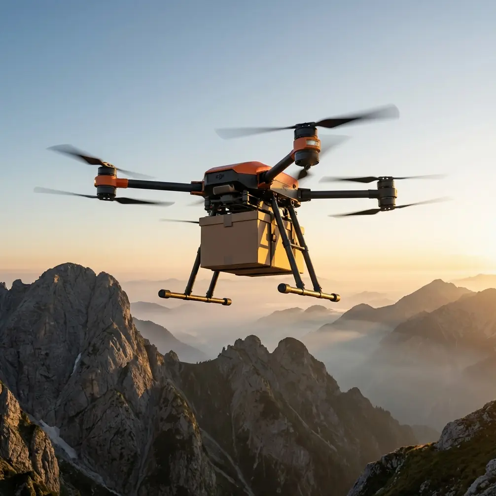
That is where the FlyCart 30 becomes relevant.
I’m approaching this as a logistics problem, not as a spec-sheet exercise. Coastal vineyards create a stubborn mix of operational friction: broken terrain, rows that distort line-of-sight, wind rolling in from open water, and landing zones that are often less convenient than they look on a map. Add crates, sensors, irrigation parts, samples, or emergency supplies, and suddenly the mission is not about pretty flight footage. It is about moving something that matters, on time, without improvisation.
The recent launch of Matternet’s NHS delivery service in Central London gives us a useful civilian benchmark. Two details stand out. First, this was Matternet’s first deployment in the United Kingdom. Second, the route is bi-directional between two major hospital campuses, built specifically to move critical medical items in minutes. Those facts matter because they show where commercial drone delivery is maturing: not in abstract demos, but in fixed corridors where route discipline, turnaround efficiency, and trust in the system are non-negotiable.
For FlyCart 30 operators in coastal vineyards, the lesson is straightforward. The value is not merely that the aircraft can carry a payload. The value is that a route can be designed, repeated, and optimized until it becomes part of daily operations.
The real vineyard problem is not distance alone
People often frame cargo drone work around maximum range. That is too simplistic for coastal vineyards.
The harder problem is consistency across short-to-medium routes with environmental interference. In practice, many vineyard missions are repetitive:
- moving harvested samples from a block to a processing point
- sending repair tools to a pump station
- dropping treatment material to a steep section
- delivering sensors, spares, or field kits to crews spread across multiple parcels
- carrying urgent items when ground access is slowed by mud, slope, or internal traffic
A road vehicle can do those jobs, eventually. But “eventually” is exactly what drone logistics is trying to compress. That is why the London hospital example matters. The NHS route was not launched to prove drones are futuristic. It was launched because moving critical items in minutes changes how an operation behaves. In vineyards, the same logic applies when timing affects labor flow, crop handling, or equipment downtime.
The FlyCart 30 fits that kind of mission profile because it is built around practical load movement, not visual media capture. Payload ratio becomes central here. If your aircraft weight and carried load are not balanced intelligently, your route economics collapse. Every unnecessary kilogram reduces flexibility. Every badly packed load amplifies pendulum movement, especially in crosswinds common to coastal sites.
Why payload ratio matters more near the coast
In a sheltered inland property, operators can sometimes get away with less disciplined load planning. Coastal vineyards are less forgiving.
Salt air, gust fronts, and ridge turbulence all punish sloppy payload management. A FlyCart 30 mission should be planned around payload ratio, not just payload maximum. The distinction matters. A lighter, correctly secured load can outperform a heavier “within-limit” load because the aircraft retains more margin for route correction, climb performance, and stable delivery in variable wind.
Operationally, that means three things:
Standardize container weights
Do not let every team invent its own packaging. Create fixed load classes. If crews know a sample case, tool pack, and irrigation repair box each fit within known limits, dispatch becomes faster and safer.Control load shape, not just load mass
A long awkward item catches wind differently than a compact load of similar weight. In vineyard lanes that run toward the coast, crosswinds can make shape more important than scale weight.Match route design to load type
A route for biological samples should not automatically be reused for a bulky maintenance kit. One may prioritize speed and directness; the other may require greater clearance or slower descent profiles.
That is where route optimization stops being software jargon and becomes useful management. The best route is not always the shortest line between two points. In vineyards, the best route may be the one that preserves signal quality, avoids known wind shear zones, and creates predictable approaches to pickup and drop-off points.
The winch system changes what “delivery point” means
One of the most practical reasons to consider the FlyCart 30 in a vineyard setting is the winch system.
A lot of cargo-drone discussions assume you need a fully open, fully clear landing area at both ends. Real sites do not always cooperate. Vines, poles, trellis wires, uneven ground, parked equipment, and crew movement all complicate landings. A winch system changes the geometry of the mission by letting the aircraft deliver without touching down in every location.
That matters in coastal vineyards for several reasons.
First, many valuable drop points are not ideal landing points. A steep service lane, a terrace edge, or a narrow clearing near a pump house may be perfectly workable for suspended delivery but poor for full touchdown.
Second, keeping the aircraft above obstacles reduces risk from ground clutter. Trellis infrastructure and wire runs can make low-level maneuvering messy. A winch lets the aircraft maintain cleaner separation while lowering cargo to a controlled point.
Third, it speeds up turnaround when crews are trained properly. If field teams know how to receive and detach loads efficiently, the drone spends less time exposed in a hover.
That last part deserves emphasis. Hover time is expensive in energy terms, especially in wind. If your receiving process is disorganized, your battery planning suffers and your route reliability goes with it.
Antenna positioning advice for maximum usable range
This is one of the most overlooked parts of FlyCart 30 deployment, and in coastal vineyards it can make the difference between a confident route and a frustrating one.
Maximum range on paper means little if your control and data link are compromised by poor antenna placement.
Here is the practical advice I give operators:
Put the control position on height, not convenience
Do not stand where the truck is parked simply because that is where everyone gathered. In vineyards, especially coastal ones, even modest elevation changes affect link quality. A control position with a cleaner line over the vine canopy and infrastructure is usually worth the extra setup effort.
Keep the antenna above nearby metal clutter
Vehicles, fencing, tanks, and utility boxes can degrade signal behavior. If your ground station is boxed in by metal objects, you are creating your own interference environment. Set up in a cleaner area whenever possible.
Face the route, not the launch pad
Some crews naturally orient around takeoff and landing. For route work, especially repeated route work, antenna orientation should reflect the main path of travel. Think in terms of the signal corridor, not the starting point.
Avoid masking from buildings and tree lines
A coastal property often has mixed terrain plus windbreak vegetation. A building corner or dense tree line can degrade connectivity as the aircraft transitions away from launch. Watch the first segment of the route carefully; weak link performance often starts there.
Test at operational altitude, not just at eye level assumptions
The route may look unobstructed on the ground and still behave differently once the aircraft is flying over rows, irrigation structures, and topographic folds. Conduct signal checks at the actual working altitudes you intend to use.
Build repeatable antenna marks
Once you find the best position, mark it. Literally. Paint, stake, or map the exact controller location and antenna orientation for future use. Repeatability is a logistics asset.
If your team needs a second opinion on site layout or relay planning, this quick FlyCart 30 route chat can help: https://wa.me/85255379740
Dual-battery thinking is really continuity planning
The phrase “dual-battery” often gets treated as a feature bullet. It should be treated as a continuity tool.
For vineyard operators, continuity means a route survives routine friction: delayed loading, extra hover time, weather shifts, or an unplanned second trip. Dual-battery architecture supports that mindset by giving operators a more resilient energy framework than ad hoc single-mission thinking.
This becomes particularly significant when your drone operation starts behaving like a service rather than an experiment. Again, the Matternet NHS route offers a useful mental model. A bi-directional service connecting hospital campuses is not interesting because it flies once. It is interesting because it must keep functioning as a reliable link in a broader workflow.
That is exactly how mature vineyard drone logistics should be viewed. If the drone only works when conditions are perfect and everyone has extra time, it is not yet operationally meaningful.
BVLOS is not just about permission. It is about discipline.
BVLOS gets a lot of attention for regulatory reasons, but from an operational standpoint the bigger issue is process quality.
In large estates or multi-parcel coastal vineyards, BVLOS planning changes the economics of cargo movement. Yet BVLOS only creates value if the route, communication plan, contingency procedures, and payload handling standards are all stable enough to support it.
The London medical route highlights this principle indirectly. When a service is designed to move critical medical items in minutes between two hospital campuses, every step has to be tightly controlled. The same mindset applies to FlyCart 30 route expansion. Before chasing longer distances, tighten the short route first.
That means:
- define exact launch and recovery procedures
- standardize package attachment
- assign responsibility for route checks
- document weather thresholds
- train receiving crews, not only pilots
- build an incident response process around communication failures and landing alternatives
BVLOS capability without those basics is just extra complexity.
Emergency parachute planning should be site-specific
An emergency parachute is one of those systems people mention without fully integrating into route planning. In a coastal vineyard, site-specific thinking matters.
You need to know where a descent event would be most manageable. Over open service lanes? Over low-risk buffer zones? Away from worker congregation points and away from dense infrastructure? Those questions should shape your route design from the start.
This is another reason why route optimization is broader than shortest-path logic. The best corridor may be slightly longer if it gives you cleaner contingency geography. Safety margins that exist only on paper are not enough. You want real, practical fallback space.
What the NHS route teaches FlyCart 30 operators
Let’s connect the threads.
Matternet’s first UK deployment with the NHS in Central London is notable because it links two major hospital campuses in a bi-directional route and moves critical medical items in minutes. That tells us commercial drone logistics is being judged by repeatable service value, not novelty.
For FlyCart 30 operators in coastal vineyards, the operational takeaway is clear:
- build around recurring routes, not occasional flights
- treat payload ratio as a performance lever
- use the winch system to access difficult drop points without forcing unnecessary landings
- plan antenna position as carefully as you plan the route itself
- think of dual-battery design as continuity support
- approach BVLOS as a process discipline
- factor emergency parachute logic into corridor selection
The result is not just a drone that can lift cargo. It is a logistics layer that can shorten response times inside the vineyard, stabilize field support, and reduce dependency on slower ground movements across awkward terrain.
That is the real story. Not whether the FlyCart 30 is impressive on paper, but whether it can become useful enough, often enough, that crews start planning their day around it.
In the right coastal vineyard, with disciplined setup and route design, the answer is yes.
Ready for your own FlyCart 30? Contact our team for expert consultation.