FlyCart 30 for Urban Wildlife Work: What Hubei’s Low
FlyCart 30 for Urban Wildlife Work: What Hubei’s Low-Altitude Buildout Signals for Safer, Smarter Operations
META: A practical expert look at FlyCart 30 for urban wildlife capture support, grounded in Hubei’s 2025 low-altitude flight platform strategy, logistics expansion, route control, and safer city-edge operations.
Urban wildlife work rarely looks dramatic from the outside. Most missions are shaped by restraint, not speed. A team gets a call about an injured egret near a riverside overpass, a macaque moving between residential roofs, or a deer trapped along a fenced logistics corridor. The hard part is almost never “getting a drone in the air.” The hard part is operating in a crowded low-altitude environment without adding confusion, risk, or delay.
That is why the most useful way to think about the FlyCart 30 is not as a payload drone in isolation, but as part of a larger low-altitude operating system.
A recent development story out of Hubei offers an unusually clear lens for this. In 2025, the province accelerated its low-altitude economy strategy under a framework that emphasized three priorities: stronger research and development, broader market expansion, and cultivation of leading enterprises. At the same time, it advanced what the report describes as a coordinated “three-in-one” approach. The practical centerpiece was a provincial flight service platform intended to function as the “smart hub” for low-altitude activity.
That phrase matters more than it sounds.
For FlyCart 30 operators working around urban wildlife scenarios, the real constraint is not whether the aircraft can lift, hover, or deliver. It can. The question is whether missions can be integrated into a controlled, visible, multi-use airspace environment where logistics, inspection, emergency response, and tourism activity may all share the same sky. Hubei’s push to build a low-altitude “three-dimensional network” across logistics, inspection, emergency, and sightseeing is exactly the kind of environment where a platform like the FC30 either proves its value or becomes a burden.
The problem urban wildlife teams actually face
Let’s start with the field reality.
Urban wildlife capture and recovery teams often need to move equipment into places that are difficult to reach quickly on foot. Nets, medical kits, transport boxes, thermal observation gear, baited cages, rope systems, and temporary barriers all create weight and bulk. Ground vehicles may be blocked by pedestrian density, waterways, fencing, construction zones, or narrow service roads. In some cases, a responder needs gear on the roof of a warehouse, at the edge of a wetland inside a city park, or beside an elevated rail line where access is indirect.
This is where a transport drone enters the picture. But in a city-edge wildlife context, a heavy-lift aircraft is only useful if it can do three things well:
- Move payloads with precision rather than brute force
- Fit into regulated flight corridors and service workflows
- Reduce disturbance to animals and people
The FlyCart 30’s relevance comes from how it supports those three requirements together.
Why Hubei’s 2025 model is bigger than a regional policy story
The Hubei report is centered on infrastructure and coordination, not on one aircraft. That is exactly why it is worth paying attention to if you’re evaluating the FC30.
The province’s low-altitude program is being pushed with support from the Hubei Development and Reform Commission and under the broader coordination of Hubei Airport Group. The operating company highlighted in the report is building a provincial flight service platform as the core control layer. In plain terms, that means low-altitude missions are being treated less like isolated experiments and more like managed network activity.
For FlyCart 30 operations, this changes the conversation from “Can we fly this mission?” to “Can this mission be scheduled, tracked, deconflicted, and repeated at scale?”
That is a major distinction.
Urban wildlife response often overlaps with the same operational geography used by inspection crews, emergency teams, and logistics pilots. Hubei is explicitly expanding low-altitude use across logistics, inspection, emergency response, and sightseeing. Those are very different mission types, but they all compete for predictable routing, visibility, and command structure. A provincial flight service platform acting as a smart hub gives operators a framework for route optimization, flight permission handling, conflict awareness, and mission traceability.
If you are using a FlyCart 30 to support wildlife capture in a dense urban area, that network effect is not abstract policy. It is the difference between a controlled operation and a one-off improvisation.
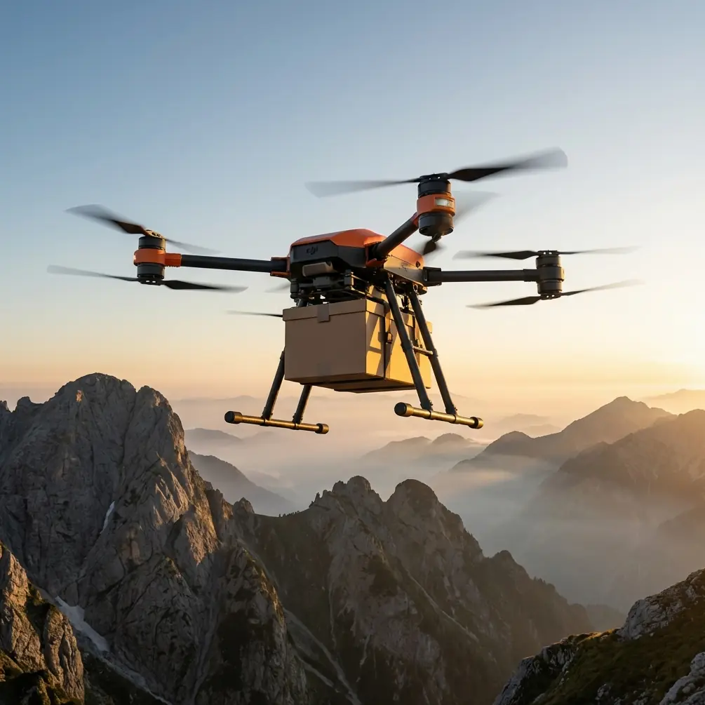
FlyCart 30 fits best when payload is only half the story
The FC30 naturally gets attention for carrying capability, but payload ratio alone doesn’t solve wildlife missions. The more serious operational value comes from how a transport drone can place tools exactly where they are needed while keeping the capture team flexible.
Take a real-world style scenario.
An injured heron is spotted on a narrow concrete service platform above an urban drainage canal. Ground access is possible, but slow. The route requires a long walk around fencing and traffic barriers. The rescue team first launches a scout aircraft and confirms the bird is mobile but not flying. During the observation pass, the sensors also detect a second obstacle: a cluster of power lines and a line of trees that create a narrow approach path.
A FlyCart 30 now becomes useful in a very specific way. Instead of moving the entire team into a compressed and risky access point, it can stage the right equipment forward. A winch system matters here because dropping a crate or dragging gear across a platform is not acceptable around a stressed animal. Lowering a compact medical pack or restraint kit from hover allows the team to deliver tools without a hard landing in a tight space. That reduces both rotor wash complications and unnecessary movement near the bird.
This is where urban wildlife readers should think beyond the common cargo narrative. In these operations, the aircraft is not “replacing” responders. It is buying time, shortening exposure, and reducing the number of people who need to enter unstable or crowded zones.
Sensor awareness can prevent a bad wildlife mission from getting worse
The context you provided points toward a wildlife encounter, so let’s stay grounded in the kind of thing experienced teams actually worry about.
On one late-summer mission near a riverside urban greenbelt, a transport route planned for gear delivery had to be adjusted when onboard sensing identified a flock of egrets lifting unexpectedly from reed cover beside a pedestrian bridge. That is the kind of detail non-operators tend to overlook. The issue wasn’t simply bird presence. It was timing, direction, and the risk of forcing the flock into traffic flow above a multi-use public path.
A capable mission plan in that moment does not insist on the original line. It reroutes, slows the approach, and changes delivery geometry. Route optimization is not just about efficiency. In wildlife operations, it is about minimizing stimulus. The “best” path is often the one that preserves animal behavior stability and public calm, even if it costs a few extra minutes.
This is also where BVLOS discussions need maturity. Beyond visual line of sight capability is often framed around range and productivity. In urban wildlife support, its real significance is continuity. If a rescue corridor runs along flood channels, rail setbacks, industrial roofs, or park boundaries, the mission may need to remain connected across sections where direct observer positioning is awkward. That only works responsibly when integrated into a structured flight service environment of the kind Hubei is building as a province-wide smart hub.
Without that wider system, BVLOS can become an administrative problem. With it, BVLOS becomes part of an organized response architecture.
Hubei’s “three-dimensional network” is the kind of ecosystem the FC30 needs
One of the most useful details in the Hubei report is the idea of the low-altitude “立体网,” or three-dimensional network. This is not branding fluff. It reflects a shift away from treating drones as isolated tools for niche departments.
For the FlyCart 30, that matters because a heavy-lift aircraft performs best inside an ecosystem that already recognizes multiple mission classes. If the same provincial framework is designed to support logistics, inspection, emergency, and tourism-related activity, operators can build standardized procedures for routing, staging, airspace visibility, and incident escalation.
Urban wildlife work benefits directly from that maturity.
Why? Because wildlife response often starts as an edge case. It may begin with one urgent call about an animal in distress. But the mission itself can touch emergency workflows, municipal asset inspection zones, traffic management considerations, and public-space communication rules. In a fragmented low-altitude environment, every mission becomes a custom negotiation. In an integrated one, you can establish repeatable protocols.
That is the hidden significance of Hubei’s development path. It suggests the future value of aircraft like the FlyCart 30 will be determined less by raw lift specs and more by how well they plug into regional service platforms.
Safety features are not accessories in this use case
Urban wildlife work is one of those sectors where safety systems become operationally central very quickly.
An emergency parachute is not just a line-item reassurance if you are moving equipment over mixed-use city terrain. It affects where teams are willing to position, how they evaluate fallback corridors, and whether a mission can proceed near roadways, canals, landscaped public areas, or building setbacks. In a crowded urban-adjacent response, redundancy and recovery planning are part of mission viability from the start.
The same is true for a dual-battery architecture. In wildlife support roles, teams often hold on station longer than expected. Animals do not follow a timetable. A bird may settle, then move. A capture lead may request one more hover pass before lowering equipment. A box trap may need repositioning. Redundant power design has operational significance because it gives the team more confidence to adapt without rushing the aircraft through the final phase of a job.
That may sound obvious. In practice, it changes decision-making. Crews make better choices when they are not trying to compress every action into a narrow energy margin.
The logistics lead’s view: don’t deploy the FC30 as a standalone hero tool
From a logistics lead perspective, the biggest mistake is treating the FlyCart 30 as a hero asset that solves everything once it arrives.
It doesn’t.
What it does do, when deployed intelligently, is compress response time between observation and intervention. It can move a cage module, a line set, or a medical bundle to a difficult point without sending extra personnel through unstable terrain. It can support route planning that respects public-space constraints. It can make it easier to separate the aircraft task from the animal-handling task. That separation is healthy. It keeps the drone in its lane: transport, positioning, and support.
Hubei’s 2025 direction reinforces that logic. The province is not betting on one-off flights. It is building around a service platform, multi-scenario expansion, and leading-operator cultivation. Those are exactly the conditions under which the FC30 becomes more valuable year after year, especially in specialized civilian missions that demand both precision and compliance.
If your team is exploring how the aircraft might fit into urban wildlife support, the right first question is not payload capacity. It is this: what operating environment are you plugging into? If the answer includes coordinated flight services, mapped low-altitude corridors, and cross-functional response planning, then the FlyCart 30 starts to make real sense.
A practical takeaway for teams planning wildlife operations
For readers trying to connect the dots, here is the short version.
The FlyCart 30 is strongest in urban wildlife scenarios when it supports a networked mission model rather than acting as an isolated transport machine. Hubei’s 2025 low-altitude strategy shows where the market is heading: province-level flight service platforms, broader scenario integration, and a managed low-altitude grid spanning logistics, inspection, emergency response, and public-facing activities.
Two details from that development are especially significant.
First, the provincial flight service platform is being built as a “smart hub.” Operationally, that means missions can be coordinated rather than improvised, which is critical for BVLOS planning, route deconfliction, and time-sensitive wildlife response.
Second, Hubei is explicitly expanding use cases across logistics, inspection, emergency, and sightseeing within a low-altitude three-dimensional network. That signals a real-world environment where the FC30 must coexist with other mission types, making precise routing, cautious delivery methods, and safety redundancy far more important than simple lift performance.
If you are planning to use the FlyCart 30 around urban wildlife, treat it as part of a structured response chain. Build procedures around the winch system. Plan routes that account for animal movement, not just obstacles. Use sensor feedback to modify behavior, not merely avoid collisions. And where possible, align operations with formal flight service structures rather than ad hoc dispatch habits.
If you want to compare deployment ideas or discuss how teams are fitting the FC30 into regulated civilian workflows, you can message our operations desk here.
Ready for your own FlyCart 30? Contact our team for expert consultation.