FlyCart 30 in Low Light: A Field Delivery Playbook Built
FlyCart 30 in Low Light: A Field Delivery Playbook Built Around Remote ID Reality
META: A practical FlyCart 30 low-light delivery tutorial covering field logistics, route planning, Remote ID awareness, payload handling, winch use, and safety workflows.
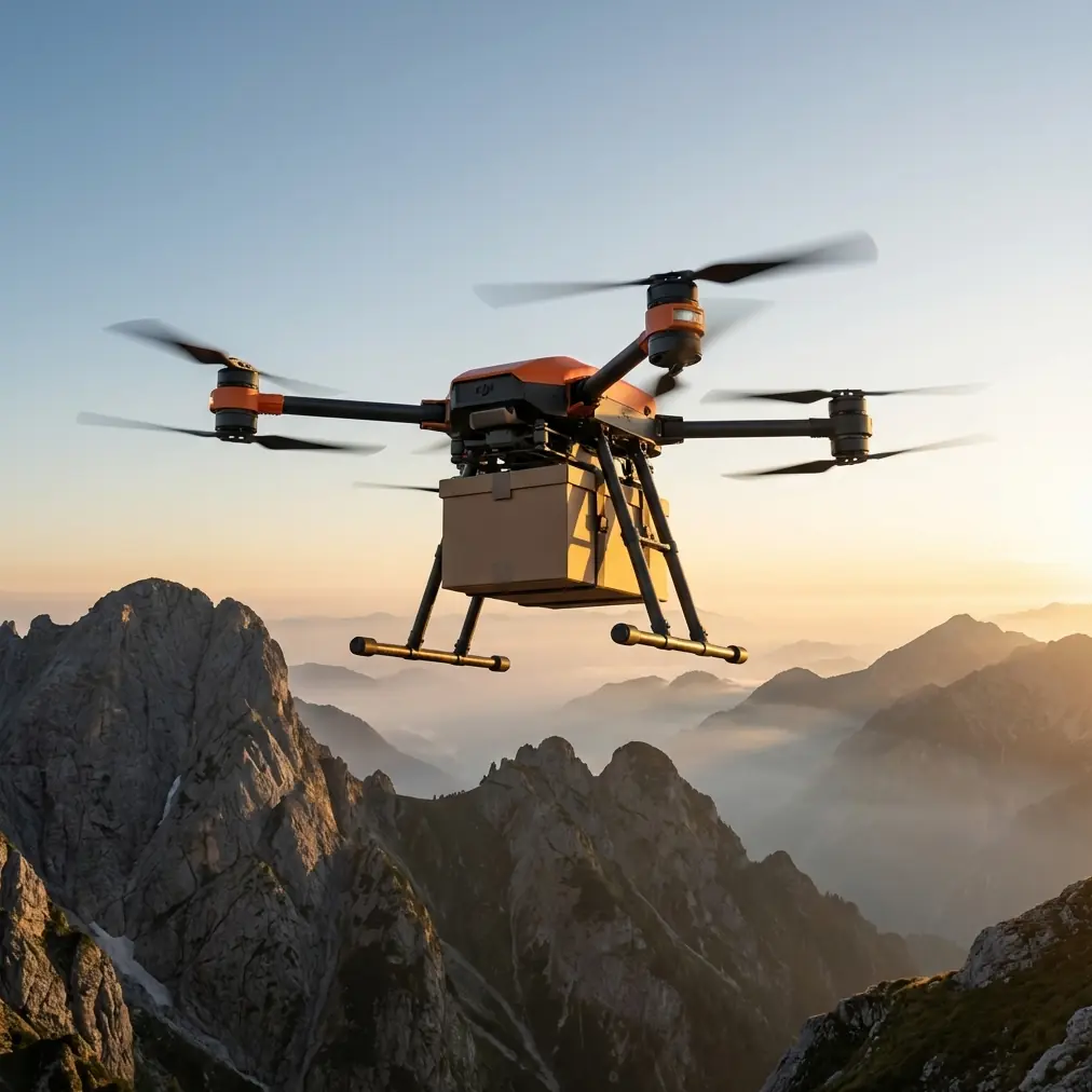
Low-light delivery sounds simple until you put a loaded aircraft over uneven ground, scattered obstacles, and patchy connectivity. That is where the FlyCart 30 stops being a spec-sheet drone and becomes an operations system.
I look at this from the logistics side. If you are moving seed, tools, crop treatment samples, irrigation parts, or urgent maintenance items across fields near dawn, dusk, or under overcast conditions, the challenge is not only flight performance. It is visibility, timing, handoff precision, and airspace accountability. The latest signal from the broader drone ecosystem makes that last point impossible to ignore.
On May 7, 2026, DroneLife reported that NASA selected Pierce Aerospace to build a Remote ID sensor network across Silicon Valley and the San Francisco Bay Area. Metis Technology Solutions chose the Indiana company to deploy YR1 and YR2S sensors to support NASA research at Ames tied to drones and air taxis. That detail matters well beyond California. It shows where the industry is heading: denser monitoring, stronger expectations around compliant operations, and more real-world observation of how aircraft behave in active environments.
For FlyCart 30 operators delivering into fields in low light, that changes the standard. You are not just asking, “Can the aircraft carry this load?” You are asking, “Can this mission stand up to a more visible, more monitored, more data-driven airspace?”
That is the right question.
Why low-light field delivery is its own discipline
Daylight hides a lot of planning mistakes. In low light, every weak point shows up.
A field that looked wide open at noon can feel very tight at sunrise. Tree lines merge into the background. Utility poles become harder to distinguish. Ground crews drift closer to the landing zone because they want a better view. Depth perception gets worse precisely when you need clean vertical separation for cargo drop or winch delivery.
The FlyCart 30 is well suited to this type of work because it was built for transport rather than pure imaging. But transport missions in low light only work when the aircraft is supported by a disciplined workflow. Payload ratio, route optimization, battery planning, and descent method all become more important than raw top speed.
If your operation includes repetitive field deliveries, especially across large agricultural properties or semi-rural work sites, low-light flights should be treated as a separate operating profile, not just a dimmer version of daytime work.
Start with the mission, not the machine
The first mistake teams make is launching from the aircraft inward. They think about batteries, payload hooks, and flight lines before defining the actual delivery problem.
For a FlyCart 30 field run, begin with four mission variables:
- What exactly is being transported
- Where the handoff will happen
- What the receiving team can realistically see and do in low light
- Whether a direct landing or winch drop is safer
This is where payload ratio becomes useful. The goal is not to push the aircraft toward its absolute lifting capacity on every sortie. In low light, a conservative payload ratio gives you more margin for route corrections, more stable handling, and a cleaner approach into uneven field environments. A mission that looks efficient on paper can become sloppy if the aircraft is working too hard during final positioning.
In practical terms, if the item is compact but awkward to land with near crops, ditches, or muddy rows, the winch system may be the better answer even if the aircraft could physically land nearby. That operational distinction matters more in low light because a controlled vertical delivery reduces the need for ground personnel to guide the aircraft into a partially visible touchdown zone.
Route optimization is not about the shortest line
On large properties, operators often default to the shortest path between dispatch point and field destination. That is not always the best path for the FlyCart 30, especially near dawn and dusk.
A better route in low light usually has three traits:
- Fewer obstacle transitions
- More predictable terrain contrast
- Easier emergency decision points
For example, a straight line across irrigation infrastructure, fence breaks, and tree edges may save seconds, but it creates more visual complexity during the phase of flight where the pilot or visual observers need the cleanest picture. A slightly longer route following a service road or field boundary can be much easier to monitor and recover if conditions shift.
This is also where BVLOS planning starts to intersect with compliance culture. Even if your current operation is not fully beyond visual line of sight, the market is moving toward environments where route accountability will matter more. NASA’s Bay Area Remote ID network is a signal of that trend. The use of YR1 and YR2S sensors for Remote ID monitoring in a real research environment means flights are increasingly understood as data events, not just aircraft movements.
For field delivery operators, the lesson is straightforward: document routes like they may later need to be explained, audited, or repeated under scrutiny. Low-light missions especially should have preplanned alternates, geofenced approach corridors, and clearly defined abort points.
Remote ID awareness now affects field logistics
Some operators still treat Remote ID as a compliance checkbox. That mindset is aging badly.
The NASA-Pierce Aerospace deployment across Silicon Valley and the San Francisco Bay Area is not just a regional technology story. It reflects a future where flight activity is easier to observe across broader coverage areas. When Pierce Aerospace says the deployment will cover the Bay Area and Silicon Valley for NASA’s Remote ID monitoring efforts, the operational takeaway is that networked awareness is becoming part of normal drone ecosystem infrastructure.
How does that affect a FlyCart 30 delivering to fields in low light?
First, consistency matters. Repeated missions should follow stable procedures so your operation remains understandable, predictable, and professionally managed.
Second, your logs matter more. If a low-light flight required a route deviation, unexpected hover, or alternate drop zone, that should be documented clearly.
Third, site selection deserves more care. If your fields are near populated edges, industrial corridors, or research-heavy airspace, the assumption should be that your operation may be more observable over time, not less.
That is not a reason to avoid delivery flights. It is a reason to run them cleanly.
The winch system is often the real low-light advantage
People talk about transport drones as if carrying the load is the hard part. Often the harder part is delivering it precisely without creating risk at the handoff point.
For low-light field work, the FlyCart 30’s winch system can be a bigger operational advantage than many teams realize. It lets you keep the aircraft above uncertain terrain while lowering cargo to a known spot. That reduces rotor wash near crops and workers, avoids muddy landing areas, and limits the need for a fully visible touchdown zone.
This matters most when the receiving area is compromised by one or more of the following:
- Wet soil after irrigation
- Tall crop edges
- Narrow access lanes
- Temporary equipment parked near the handoff point
- Workers wearing headlamps that distort visual cues
A landing can still be the right choice when the site is open, flat, and controlled. But in low light, I usually prefer a winch delivery whenever the ground picture is less than ideal. Precision in the last 10 meters often determines whether the whole mission feels routine or tense.
Dual-battery planning should be treated as mission insurance
Low-light operations leave less room for improvisation. That is why dual-battery thinking should be part of your planning process, not a technical afterthought.
Transport missions are not just out-and-back energy problems. They include hover time at dispatch, possible repositioning over the drop zone, delays while the receiving crew clears the area, and reserve power in case the first handoff attempt is rejected. In low light, those delays happen more often because visual confirmation takes longer.
A disciplined team uses battery planning to preserve decision quality. If the mission starts to feel rushed because remaining energy has become the loudest variable, the risk profile changes quickly. The point of a dual-battery architecture in real operations is not merely endurance. It is giving the crew enough margin to stay methodical.
That margin becomes even more valuable when route optimization includes a safer but slightly longer path.
Do not relegate the emergency parachute to paperwork
An emergency parachute can be the most ignored serious feature in a cargo operation because everyone assumes they will never need it. That assumption is understandable and not helpful.
In low light, emergency planning should be visible in the mission brief. Not dramatic. Just explicit.
Define:
- Where a controlled descent would be least harmful
- What areas are never acceptable for overflight during cargo transport
- How the ground team will respond if the mission aborts mid-route
- Who confirms the drop zone is clear before terminal approach
The parachute is part of a broader contingency mindset. It supports the idea that a FlyCart 30 operation should degrade safely if the unexpected happens. In fields, that may mean protecting workers, preventing cargo release into standing crops, or avoiding farm vehicles moving below a route segment.
A third-party accessory that genuinely helps
One accessory that has made a real difference in low-light field delivery is a high-output strobe mounted within a compliant, non-obstructive configuration. Not decorative lighting. A purpose-driven visibility aid for the aircraft and nearby crew.
Used correctly, a good third-party strobe improves aircraft location awareness during the approach and hover phases without changing the mission itself. It helps the receiving team maintain orientation, especially when the sky is flat gray or the aircraft is working against a dark tree line. For repetitive field runs, that extra visual cue can reduce verbal confusion during the last moments of the handoff.
The key is integration, not improvisation. Any accessory should be mounted securely, checked for interference with payload operations, and verified during short test flights before mission use.
A practical low-light FlyCart 30 workflow
Here is the framework I recommend for recurring field deliveries.
1. Build a dedicated low-light route set
Do not borrow daytime paths blindly. Walk or survey the route during the same light conditions you expect to fly.
2. Reduce payload ratio for early runs
Give the aircraft and crew more margin while refining the workflow.
3. Choose the handoff method before launch
Landing and winch delivery are different missions. Treat them that way.
4. Brief the receiving team like they are part of the aircraft system
Because they are. Their spacing, signals, lighting, and zone discipline affect the safety of the mission.
5. Log every deviation
This becomes critical as broader monitoring norms expand. The NASA-supported Remote ID sensor deployment is one more sign that repeatable, documented operations will define professional standards.
6. Standardize battery minimums for return and reserve
Never let a successful drop become a stressful recovery.
7. Predefine abort logic
If the drop zone is unclear, too crowded, or visually degraded, do not negotiate with the moment. Climb, hold if appropriate, or return.
Where to get field-specific setup help
If your team is adapting a FlyCart 30 for low-light agricultural or industrial delivery, it helps to compare mounting, handoff, and route-planning choices with people who understand cargo operations rather than generic drone use. For direct field-ops discussion, you can message our logistics team here.
The bigger picture
The most useful way to think about the FlyCart 30 is not as a flying box carrier, but as a node in a more accountable logistics network. That is why the NASA and Pierce Aerospace news matters even to someone delivering across fields. A Remote ID sensor network spanning Silicon Valley and the Bay Area, with YR1 and YR2S sensors supporting Ames research into drones and air taxis, tells us that unmanned operations are entering a phase where visibility, traceability, and system behavior all count.
For field delivery teams, low-light work is where that future shows up early. Conditions are less forgiving. Procedures matter more. The best operators will be the ones who blend practical cargo discipline with compliance maturity.
The FlyCart 30 is capable. That part is not the bottleneck. The bottleneck is whether the operation around it is built for repeatability when the light is poor, the landing zone is imperfect, and the broader airspace environment is becoming easier to monitor.
If you solve that, field delivery starts to feel less like a difficult drone mission and more like what it should be: a dependable logistics tool.
Ready for your own FlyCart 30? Contact our team for expert consultation.