FlyCart 30 in Mountain Vineyards: A Field Report on Payload
FlyCart 30 in Mountain Vineyards: A Field Report on Payload, Signal Discipline, and the New Reality Around DJI Risk
META: A field report on using the DJI FlyCart 30 for mountain vineyard delivery, covering payload planning, antenna setup, route design, winch operations, battery strategy, and how current U.S. regulatory pressure on DJI affects real-world deployment decisions.
I’m Alex Kim, and my job is logistics, not theater. When a cargo drone goes into a mountain vineyard, the useful questions are plain: can it move the load, can it hold link quality across broken terrain, and can the operator build a workflow that still makes sense when regulations tighten around the manufacturer.
That last part has become harder to ignore.
On April 10, 2026, DroneLife reported that the U.S. Department of Defense filed a memorandum with the FCC opposing DJI’s petition for reconsideration of its place on the FCC Covered List. The filing argued that DJI should remain there, citing national security concerns tied to foreign-made drone technology. It also said some of the government’s reasoning depends on classified information that cannot be fully aired in public. Operationally, that matters even for a vineyard manager who just wants to move tools, irrigation parts, or harvest samples up a ridge. A drone program is not only an aircraft decision anymore. It is also a continuity decision.
So this field report is about both realities at once: the FlyCart 30 as a working machine in mountain agriculture, and the environment around it that now affects procurement, communications planning, and long-term fleet confidence.
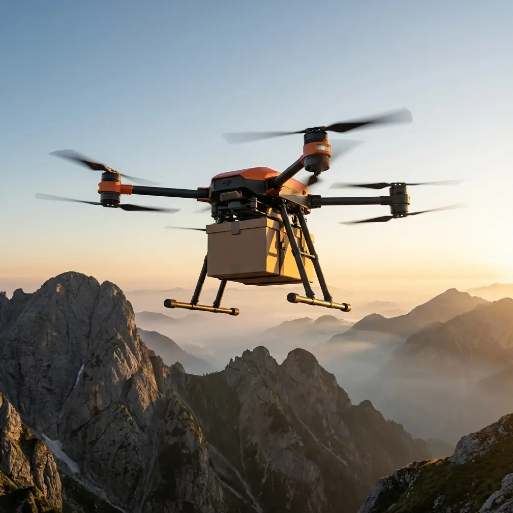
Why mountain vineyards are a real test for the FlyCart 30
Vineyards in steep terrain create the kind of logistics problem that reveals whether a cargo platform is genuinely useful or merely impressive on flat ground. Roads are narrow. Switchbacks cost time. Pickup trucks compact soil and burn labor hours just to move small but urgent items. Typical loads are not glamorous, but they are constant: pruning tools, trellis hardware, replacement emitters, field sensors, sample bins, weather gear, repair kits, nutrient test supplies.
A cargo drone only earns its place if it reduces the friction around those repeated tasks.
This is where the FlyCart 30’s design choices matter more than headline payload capacity alone. In mountain work, payload ratio is not an abstract specification. It changes whether one sortie replaces a worker’s uphill carry, whether route design remains conservative enough to preserve safety margins, and whether a team can maintain a steady rhythm during short weather windows. The difference between “can lift” and “can complete a useful cycle repeatedly” is the whole operation.
The machine’s winch system is especially relevant in vineyards cut into terraces or perched above irregular access roads. You often do not want the aircraft descending deep into a narrow, obstacle-rich pocket just to hand off a box. A controlled suspended delivery lets the drone hold a cleaner hover position while lowering cargo to a worker standing in a safer receiving zone. That is not just a convenience feature. In mountain terrain, it reduces rotor wash near vines, cuts exposure to trellis lines, and helps keep the aircraft away from uneven ground effect.
The overlooked skill that decides range: antenna positioning
Most FlyCart 30 range complaints I hear in mountainous sites are not really range complaints. They are line-of-sight discipline problems disguised as hardware disappointment.
Mountain vineyards punish sloppy antenna habits because the terrain constantly interrupts geometry. A ridge shoulder, a dense stand of trees, even a subtle fold in the slope can degrade the control and video link faster than crews expect. If you want maximum practical range, antenna positioning needs to be handled like a site procedure, not a casual setup detail.
My advice is simple and hard-earned:
- Put the pilot station on elevation when possible, not at the nicest parking spot.
- Face the likely route corridor, not the takeoff pad.
- Keep the controller antennas oriented to present their strongest radiation pattern toward the aircraft’s flight path rather than pointing the antenna tips directly at it.
- Avoid standing beside vehicles, metal sheds, or large irrigation infrastructure that can reflect or mask signal.
- If the route crosses behind a ridgeline, move the control point before launch or redesign the path. Don’t “see what happens.”
That last mistake is common. Teams will build a route based on cargo destination instead of RF visibility. In mountain operations, route optimization starts with link geometry, then payload efficiency, then time. Not the other way around.
When I scout a vineyard, I usually mark three things before discussing delivery frequency: the best control station, the alternate control station, and the dead zone boundary where terrain shadow begins. Once those are mapped, the rest of the plan becomes much more realistic. If you need another set of eyes on route layout or signal positioning, our operations desk can review field screenshots here: message our team directly.
Route optimization in vineyards is not about shortest distance
A straight line on a map is often the wrong line in the field.
For FlyCart 30 runs in mountain vineyards, the best route is usually the one that preserves consistent signal exposure, gives the aircraft clear escape options, and avoids repeated transitions over workers or sensitive crop rows. That may add distance, but it often cuts total mission risk. BVLOS planning, where permitted and properly authorized, becomes especially dependent on this mindset. If a team is thinking about beyond visual line of sight workflows for larger estates, route design has to account for terrain masking, handoff procedures, weather drift at different elevations, and emergency landing logic long before anyone talks about throughput.
This is where current regulatory pressure around DJI changes the conversation. The Department of Defense filing to the FCC is not a technical flight manual, but it does shape the operational backdrop. If a federal agency is formally asking the FCC to keep DJI on the Covered List, and is doing so partly on grounds that include classified information, vineyard operators and service providers need to think beyond immediate aircraft performance. They should ask:
- Will my communications architecture still be acceptable to my clients and insurers?
- What documentation will I need for internal risk review?
- If my operation expands, will this platform create procurement resistance later?
- Can I support continuity if policy or connectivity conditions change?
Those are not political questions in the field. They are scheduling questions, contract questions, and fleet planning questions.
Using the winch system where roads and terraces fight you
The winch system changes the usefulness of the aircraft in a mountain vineyard more than many first-time observers realize. On paper, it sounds like a cargo handling feature. In practice, it is a terrain adapter.
Consider a mid-slope block where the nearest vehicle approach is a rough road below the vines and the receiving crew is standing on a terrace edge above. Landing the aircraft there may expose it to line catches, loose dust, and poor visual depth cues. A winch drop lets the operator hover in a cleaner envelope and lower the cargo to a controlled pickup point.
That matters for three reasons.
First, it protects the aircraft from unnecessary proximity to trellis infrastructure. Vineyard geometry is unforgiving. Wires, posts, anti-hail net supports, and irrigation lines create visual clutter that can punish even a capable pilot.
Second, it improves crew safety and consistency. The receiving worker focuses on cargo transfer rather than aircraft clearance.
Third, it speeds repeat cycles. When the handoff point is standardized, the mission becomes a process instead of a fresh improvisation each time.
The hidden benefit is battery management. Shorter hover uncertainty at low altitude means more predictable energy use. In mountain sites, where wind can shift sharply from one contour to the next, predictable consumption is worth more than optimistic estimates.
Dual-battery thinking is really continuity thinking
Dual-battery architecture gets discussed as a redundancy feature, which is true but incomplete. In a working vineyard, it is also a continuity feature.
Cargo flights in mountain terrain often involve frequent short missions with quick operational decisions between them. A stable battery workflow helps the team preserve dispatch rhythm. It also supports a more disciplined approach to reserve policy. That is essential when your route is not simply out-and-back over open ground, but over staggered elevation and variable wind channels.
The mistake I see is crews treating battery state as if the return leg will resemble the outbound leg. In vineyards, especially late afternoon, the wind can stiffen unpredictably on exposed rows and fall off near sheltered terraces. If the aircraft carried a load uphill and returns lighter, operators may assume the return is automatically easy. Sometimes it is. Sometimes the route home faces the stronger headwind.
A better method is to assign battery decision points to terrain checkpoints, not just percentages. That keeps the operation tied to reality instead of dashboard optimism.
Emergency parachute planning should be operational, not decorative
People like to mention emergency parachute systems because they sound reassuring. But in mountain agriculture, the value lies in where and how the team expects that system to fit into the broader emergency plan.
A parachute is not permission to get careless over workers, roads, or infrastructure. It is a mitigation layer. Its real usefulness depends on route selection, exclusion zones, and disciplined altitude profiles. In vineyards, that means avoiding flight paths that put the aircraft over occupied work clusters when an alternate corridor exists. It also means setting receiver locations that are clear of secondary hazards if a mission is interrupted.
If your emergency planning starts and ends with “the aircraft has a parachute,” then you have not planned much. The correct mindset is that the parachute supports a route already designed to degrade safely.
The policy issue is now part of deployment planning
The DroneLife report should not be read as distant Washington noise. The Department of Defense memorandum opposing DJI’s request at the FCC has direct significance for any business considering a FlyCart 30 workflow in the United States, or for multinational operators managing compliance expectations across markets.
Two details stand out.
The first is procedural: the Pentagon explicitly asked the FCC to reject DJI’s petition and keep the company on the Covered List. That is not ambiguity. For operators, it signals that policy friction around DJI is not fading quietly into the background.
The second is informational: the filing says some concerns rely on classified information that cannot be fully discussed publicly. Whether or not a field operator ever sees those details, the practical effect is clear. Risk assessments may increasingly be shaped by information outside the normal public technical debate. That can influence customer approval, public-sector contracting, financing, and internal governance.
In plain terms, a vineyard operation looking at the FlyCart 30 should separate two questions that often get blurred together:
- Is the aircraft operationally capable for our terrain and payload profile?
- Is the platform strategically durable for our organization over the life of the program?
For many sites, the answer to the first may still be yes. The second now requires more deliberate review than it did before this filing.
My field takeaway on the FlyCart 30 for vineyard delivery
As a machine, the FlyCart 30 fits mountain vineyard logistics best when the operation values repeatable cargo movements over spectacle. It is strongest where the team has mapped signal geometry, built routes around terrain instead of around wishful straight lines, and uses the winch system to avoid forcing landings into bad spaces. Its payload ratio matters because mountain work punishes inefficiency. Its dual-battery workflow matters because short-cycle logistics lives or dies on continuity. Its emergency parachute matters only when route planning is mature enough to make that layer meaningful.
But no honest field report can stop at aircraft behavior. The wider climate around DJI now belongs in the deployment brief. The April 2026 Department of Defense filing to the FCC is a reminder that performance and policy are now intertwined. If you are planning FlyCart 30 use in vineyards, you need both an operations plan and an institutional risk plan.
That is the real expert view from the hill: the aircraft may solve the uphill delivery problem, but the program still has to survive the downhill pressure from regulation, client scrutiny, and long-term compliance.
Ready for your own FlyCart 30? Contact our team for expert consultation.