FlyCart 30 for Forest Filming in Mountain Terrain
FlyCart 30 for Forest Filming in Mountain Terrain: What a Real Grid Fire Response Tells Us About Safe Payload Work
META: A technical review of the DJI FlyCart 30 for mountain forest filming, using a real Xinjiang power-grid drone operation to examine payload control, altitude strategy, winch use, BVLOS workflow, dual-battery planning, and operational safety.
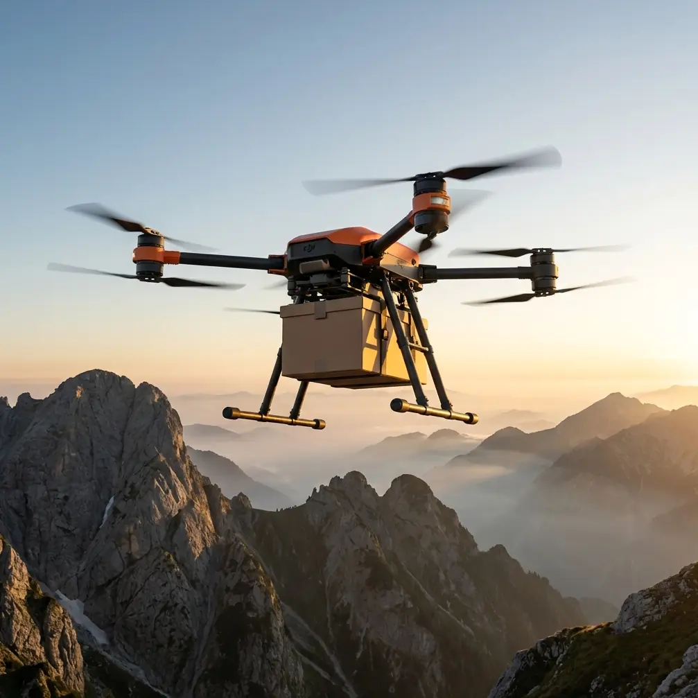
When people look at the FlyCart 30, they usually see a cargo drone. That is true, but it is not the whole story. In mountain forest production work, especially when the mission involves moving cameras, rigging, sensors, batteries, line tools, or emergency support gear into difficult terrain, the aircraft becomes something else: a logistics platform that can keep a filming operation moving when roads, slopes, and tree cover start working against the crew.
A recent utility operation in Xinjiang is a useful anchor point for understanding that difference. On April 7, State Grid Xinjiang Electric Power reportedly used a heavy-payload drone for the first time to handle a fire hazard in a transmission corridor. The aircraft carried out a precise drop of fire-extinguishing munitions inside the corridor of the 750 kV Wuge No. 1 line and removed a sudden smoke-and-fire risk. That detail matters. Not because forest filming and utility fire response are the same mission. They are not. It matters because it shows what heavy-payload drone work actually demands in the real world: stable positioning, controlled release, disciplined route planning, and confidence around obstacles in a narrow operating corridor.
Those are exactly the qualities that determine whether a FlyCart 30 is merely interesting on paper or genuinely useful on a mountain forest shoot.
Why a power-line corridor incident is relevant to a filming workflow
The Xinjiang operation was not a marketing demo. It was a practical task in a constrained environment. A transmission corridor has tight spatial limits, terrain variables, and serious consequences for placement error. The reported use case involved a heavy-lift drone making a precise payload drop to eliminate an active hazard, not just transporting something from point A to point B.
For a forest filming team, the parallel is straightforward. Mountain shoots are full of “corridor” problems:
- narrow clearings for delivery
- uneven canopy height
- wind shear near ridgelines
- limited landing zones
- pressure to place equipment exactly where the crew needs it
If a platform can work with accuracy in a utility corridor associated with a 750 kV transmission line, that suggests a level of positional control and payload management that deserves serious attention from production planners. Again, the mission type is different, but the operational lesson is the same: precision under terrain pressure is where a heavy-payload aircraft proves its value.
The FlyCart 30 is most useful when the mountain defeats the van
In mountain forest filming, the hardest logistics problem is often not the camera move. It is the hour before it. Batteries need to get uphill. A cable cam component was left at base. A weather station has to be placed on a ridge. A LiDAR payload or compact cinema package needs to reach a lookout point without sending two crew members on a dangerous climb through wet timber.
This is where payload ratio becomes more than a specification-sheet term. A useful transport drone is not judged only by maximum payload. It is judged by how efficiently it converts aircraft mass, battery energy, and trip count into workable logistics. If one airframe can replace multiple hand-carry runs, the production day changes shape. Fewer fatigue-related delays. Less crew exposure on steep trails. Better schedule discipline during short weather windows.
That is why the Xinjiang example is operationally significant. The first reported use by State Grid Xinjiang Electric Power was not framed as simple aerial transport. It was an application where the payload had to arrive in a usable way at the exact moment and place required. For filming teams in the mountains, that same standard applies to delivering lens cases, radio repeaters, lightweight gimbal kits, field monitors, or emergency med support.
Optimal flight altitude for filming forests in mountain terrain
The most common altitude mistake in mountain forest support flights is going too low simply because the destination is under canopy or near trees. That usually creates more risk, not less.
For FlyCart 30 logistics support in this scenario, the smarter operating habit is to cruise above local canopy with a deliberate vertical buffer, then descend only at the delivery zone. In practical terms, I like to think in layers rather than one universal altitude.
For transit across forested slopes, a sound starting point is roughly 30 to 50 meters above the highest nearby canopy in the immediate route segment, adjusted for wind, terrain rise, and local regulations. In mountain terrain, absolute altitude above takeoff point means very little by itself. Relative clearance over the terrain and trees is what matters.
Why that band?
- Below that, you are more exposed to rotor wash interaction with treetops, visual deception from rising slopes, and snag risk from isolated tall trees.
- Far above that, you may lose efficiency in some wind conditions and make the descent profile into tight delivery points less predictable.
Near ridgelines, I usually advise adding extra vertical margin because mountain wind rarely behaves like the forecast says it should. Air can roll over the crest, sink abruptly on the lee side, or create lateral push that is easy to underestimate when the drone is carrying a useful load. If the route crosses a saddle or a spur line, plan the altitude around the highest hazard on the segment, not the average terrain.
For the final drop or winch operation, lower is not automatically better. The right altitude is the one that gives the payload stable behavior and preserves escape options. In trees, that often means holding high enough to keep the aircraft out of branch conflict while using the winch system to bridge the last vertical gap.
Why the winch system changes the mountain workflow
A heavy-lift drone with a hook is helpful. A heavy-lift drone with a controlled winch is a different class of tool.
In forest filming, the winch system often matters more than raw lifting power because very few mountain locations offer clean touchdown surfaces. Wet brush, loose rock, roots, and narrow openings can all make direct landing a poor idea. A winch lets the aircraft remain in cleaner air above the problem while the payload goes down to the crew.
That does three things.
First, it reduces landing exposure. The aircraft does not need to commit to uncertain ground conditions.
Second, it improves delivery precision. A crew member can receive the load at a manageable point instead of forcing the aircraft into an awkward descent through branches or uneven terrain.
Third, it protects the mission clock. Touch-and-go style deliveries in mountain forest environments often create delays because crews spend too much time trying to improvise a landing zone.
The Xinjiang fire-response report highlighted precise payload placement as the defining success factor. That is the lesson to carry over. In a mountain filming workflow, precision is not just about where the drone flies. It is about where the payload ends up and how little chaos is created in getting it there.
Dual-battery planning is not a luxury in mountain operations
Anyone treating dual-battery architecture as a convenience feature is probably planning flights from flat ground.
In mountain forest work, battery strategy is tied directly to margin. Terrain changes can lengthen the effective route. Wind can turn a routine outbound leg into a marginal return. Repositioning to preserve line of sight can add time. Waiting for the ground team to clear a receiving point can add hover minutes you did not budget for.
A dual-battery setup helps in two ways: resilience and tempo. Resilience matters because payload flights in mountains should not be flown with fragile reserve assumptions. Tempo matters because production days are built around repeated movement, not one idealized mission.
The wrong way to think about capacity is “Can the drone do this trip?” The right question is “Can the drone do this trip, with this payload, in this wind, with enough reserve to absorb delay and still return without compressing safety margins?”
That is also why route optimization matters more than pilots often admit.
Route optimization is how you make BVLOS-style thinking useful, even when regulations vary
Even when the job is not conducted under formal BVLOS approval, mountain work benefits from BVLOS discipline in planning. By that I mean segmenting the route, identifying terrain blockers, preselecting contingency points, and avoiding lazy straight-line assumptions.
A line on the map over a forested mountain is often fiction. The actual route needs to account for:
- terrain masking of signal and visibility
- updraft and downdraft zones
- emergency loiter points
- alternate delivery zones
- safe jettison logic for non-hazardous payloads if required by procedure
- return-path energy budget under changing weather
The Xinjiang operation involved work in a power-line corridor, which is a classic example of a route where positional discipline matters more than speed. In mountain filming support, that same mindset pays off. The best route is not necessarily the shortest. It is the route with the fewest surprises.
If your crew is building a repeatable transport lane between base camp and an overlook, scout and standardize it. Give every segment a name. Log wind behavior by time of day. Note where the aircraft should climb early rather than trying to outmaneuver terrain late.
Emergency parachute logic in forest environments
An emergency parachute can sound reassuring in a brochure, but in a dense forest it should be understood realistically. It is not a magic reset button. It is a last-line mitigation feature whose usefulness depends on altitude, deployment logic, and what is below.
In mountain filming support, the real benefit is that it adds a layer to your risk stack for aircraft failure scenarios, especially when operating over difficult ground where an uncontrolled descent could create serious asset damage or endanger crew members moving below. But it does not replace route discipline, conservative weather calls, or good stand-off from the team.
Think of it as a system that supports your safety architecture, not a reason to accept bad geometry.
A practical setup for forest filming support
If I were deploying FlyCart 30 as logistics support for a mountain forest production, I would build the operation around three lanes of work.
Lane 1: Base-to-ridge transport
Use the aircraft to move batteries, compact camera accessories, signal relays, and field support tools from staging to a stable handoff zone above the main set area.
Lane 2: Winch delivery into imperfect locations
For places with no safe landing area, keep the aircraft above canopy margin and use the winch for the last vertical segment.
Lane 3: Contingency support
Reserve battery and scheduling space for unplanned runs. In the mountains, the mission that matters most is often the one nobody expected at dawn.
This is also where good communications matter. If you are sorting out a workflow for a specific terrain profile or cargo mix, it is worth discussing the route geometry and drop method before the first field day. A direct planning conversation is usually more useful than another generic brochure, and teams that want to compare mission setups can use this FlyCart 30 operations chat.
What the Xinjiang case really tells us
The most valuable detail in the Xinjiang report is not just that a drone was used. It is that this was the first time State Grid Xinjiang Electric Power used a heavy-payload drone in that line-fire handling role, and that the aircraft successfully made a precise drop in the corridor of the 750 kV Wuge No. 1 transmission line to eliminate a sudden smoke-and-fire hazard.
That gives us two grounded insights.
First, heavy-lift drones are being trusted for tasks where placement accuracy has direct operational consequences. Precision is no longer a nice extra. It is the mission.
Second, the value of these aircraft is highest in environments where access is constrained and response time matters. That is exactly why the FlyCart 30 belongs in serious conversations about mountain forest filming support. Not because it is fashionable to use drones for everything, but because there are terrain conditions where carrying gear by foot is slower, riskier, and harder on the crew than it needs to be.
For a filming team, the takeaway is simple. The FlyCart 30 is not the star of the shoot. It is the machine that helps the shoot happen on time, in the right place, with fewer compromises.
And in the mountains, that can be the difference between catching the light and missing the day.
Ready for your own FlyCart 30? Contact our team for expert consultation.