FlyCart 30 for Coastal Wildlife Filming: A Field Report
FlyCart 30 for Coastal Wildlife Filming: A Field Report on Airspace Discipline, Safer Delivery, and the Altitude That Actually Works
META: Expert field report on using FlyCart 30 in coastal wildlife filming support, with practical altitude guidance, airspace coordination insights, and operational takeaways from Sichuan’s low-altitude service center recruitment news.
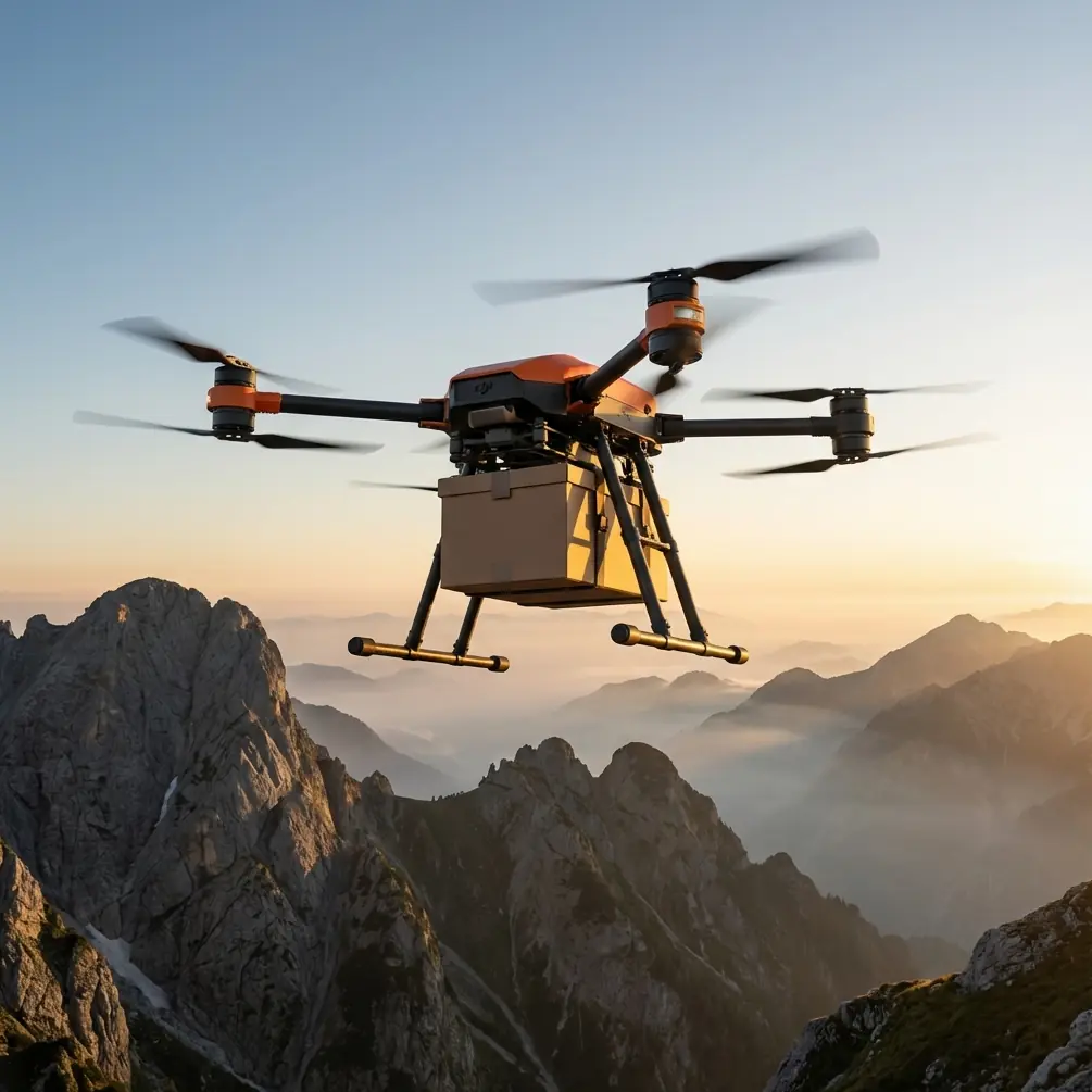
When people talk about the DJI FlyCart 30, they usually jump straight to payload and delivery. That misses where the aircraft becomes genuinely useful for film crews working around wildlife on the coast. In that environment, the aircraft is rarely the star. It is the logistics layer behind the shot: moving batteries, lenses, audio kits, hides, weatherproof cases, and emergency consumables into places that are awkward to reach without trampling habitat or wasting a tide window.
That distinction matters.
A wildlife crew operating along tidal flats, dunes, mangroves, or rocky shorelines has a different problem from a conventional cargo mission. The mission is not simply to move weight from A to B. It is to do it quietly, predictably, and inside a narrow operational envelope shaped by birds, wind, salt, changing visibility, and often fragmented access routes on the ground. In that setting, the FlyCart 30’s value comes from disciplined route design, controlled load handling, and airspace awareness more than from raw lifting ability alone.
A recent signal from China’s low-altitude aviation ecosystem is worth paying attention to here. UAVCN reported that the Sichuan Provincial Low-Altitude Airspace Operation Service Center is recruiting, and the headline explicitly says the roles “have establishment”—in other words, they are formal staffed positions rather than ad hoc appointments. The story did not publish role details, headcount, conditions, or deadlines. Even so, two facts stand out: first, the hiring unit is specifically a low-altitude airspace operation service center; second, the positions are formalized. That may sound like administrative trivia. It is not.
For anyone planning commercial FlyCart 30 work, especially in sensitive locations such as coastal wildlife zones, this is the operational backdrop that matters most. Low-altitude activity is becoming structured. Not just tolerated, not just experimented with—structured. When a provincial-level center dedicated to low-altitude airspace operations is hiring into official posts, it signals something larger than one job notice. It suggests that low-altitude coordination, service support, and traffic management are moving toward institutional normalcy.
If you are flying a cargo platform like the FlyCart 30 near a film set, that changes how you should think about mission design.
Why this matters to FlyCart 30 operators supporting wildlife productions
The FlyCart 30 is often assessed through a single lens: how much can it carry? That is only half the conversation. The better metric in the field is payload ratio—how much useful mission value you create per sortie relative to the aircraft’s energy reserve, terrain constraints, and disturbance footprint.
For a coastal wildlife production, the “best” load is not always the heaviest one. A denser load profile can force lower route flexibility, tighter battery margins, slower repositioning, and more complicated pickup and drop procedures. If your crew is staged behind dunes or on a shoreline bluff with no clean landing zone, the winch system starts to matter more than max payload on paper. It lets the aircraft hold a safer position while lowering equipment into a controlled drop zone, instead of bringing the whole aircraft into a risky near-ground hover close to brush, salt spray, or uneven surfaces.
That is not a small distinction. Near wildlife habitat, ground effect, rotor wash, and visual disturbance all compound as you descend too close to the surface. A winch-supported delivery can reduce site intrusion if the crew has prepared the receiving zone correctly.
The second operational layer is redundancy. Coastal work burns through contingency options fast. Wind shifts. Fog builds. Salt moisture affects handling. A sandbar you thought was accessible on foot is cut off an hour later. That is why the FlyCart 30’s dual-battery architecture is not just a specification to quote in a brochure. For real operations, it underpins dispatch confidence. Not because it removes risk—nothing does—but because it supports steadier energy planning when the mission includes offshore edges, variable wind return legs, or alternate drop points.
And in wildlife filming, alternates are everything.
The altitude question: what actually works on the coast
The prompt here asks for an optimal flight altitude insight, and this is where crews often get sloppy. There is no universal “perfect” number because species sensitivity, local terrain, airspace rules, and weather all vary. But for coastal wildlife filming support missions, a practical planning window for FlyCart 30 transit legs is often around 60 to 90 meters AGL, then adjusted upward or downward based on bird activity, topography, and local restrictions.
Why that band?
At that height, you are often high enough to reduce immediate acoustic and visual pressure on shoreline subjects compared with very low transit, while still staying in a manageable envelope for route observation, communications, and delivery positioning. Go too low and you amplify noise signature at the habitat edge, increase bird interaction risk, and create turbulence issues near cliffs, dunes, or man-made coastal structures. Go too high and you may complicate line-of-sight management, expose the aircraft more to stronger winds aloft, and make the descent profile to the handoff point less efficient.
The number is not the lesson, though. The lesson is segmentation.
For wildlife support, I recommend dividing the mission into three altitude phases:
Transit corridor phase
Keep the route predictable and relatively higher within the approved envelope, commonly in that 60–90 meter AGL zone if site conditions permit.Buffer phase near the habitat edge
Slow down before the delivery zone. This is where route optimization matters. The best path is rarely the shortest line. It is the line that avoids crossing directly over roosting areas, nesting zones, or feeding clusters.Delivery phase
Use the winch system where possible to avoid an unnecessarily low aircraft position. If descent is required, make it brief, stable, and pre-briefed.
That structure reduces chaos. Wildlife crews do not need dramatic flying. They need repeatable logistics.
BVLOS thinking without letting BVLOS become a crutch
There is a temptation in cargo drone conversations to invoke BVLOS as the answer to every efficiency problem. For coastal productions, that can be misguided. BVLOS can absolutely expand utility across stretched shorelines or island-adjacent work zones, but only when route governance, detect-and-avoid procedures, communications resilience, and local approvals are mature enough to support it.
This is exactly why the Sichuan recruitment item matters beyond Sichuan. A formal low-altitude airspace operation service center implies the industry is building the connective tissue needed for more routine, structured drone operations. If those service functions mature across regions, FlyCart 30 operators can plan with better confidence around corridor allocation, traffic visibility, and operational coordination. That makes sophisticated missions more realistic. It does not mean crews should rush into long-range operations where wildlife sensitivity and coastal weather create extra uncertainty.
For now, the smarter approach is to borrow BVLOS discipline even for shorter visual-line-of-sight missions:
- predefine emergency diversion points,
- establish route checkpoints,
- maintain clear loss-link actions,
- map no-fly buffers around sensitive animal concentrations,
- and avoid improvising around changing bird movement.
Formalized low-altitude management will reward operators who are already acting like a system participant, not a lone pilot.
The quiet force multiplier: route optimization
On wildlife jobs, route optimization is not about shaving seconds for vanity metrics. It is about reducing exposure—exposure of the aircraft to wind, exposure of the crew to access hazards, and exposure of wildlife to unnecessary disturbances.
A naive route from vehicle base to shoreline blind might cut directly across open habitat. An optimized route may be longer on the map but smarter in practice: follow a less sensitive edge, cross water only where recovery options exist, avoid cliff updraft zones, and approach the crew from behind terrain shielding if possible. That kind of route design often improves the payload ratio in the real world because fewer aborted approaches and fewer unstable hover corrections mean fewer wasted watt-hours.
This is where cargo drone operations start to look less like “delivery” and more like airfield-grade planning on a compact scale.
If your team is building that kind of workflow and needs a second opinion on setup logic, flight envelopes, or site-specific mission planning, a direct operational discussion often helps more than another spec sheet: message our team here.
Emergency systems are not optional in this environment
Coastal terrain is unforgiving. You may have water on one side, scrub on the other, and no clean forced-landing area where you actually need one. That is why an emergency parachute is not just a compliance talking point in a FlyCart 30 conversation. In support missions for filming crews, it forms part of the risk-control stack, especially when you are transporting equipment over mixed terrain where a conventional emergency descent could create additional hazards.
That said, parachute thinking should never replace route discipline. If your route depends on the parachute saving a bad plan, the route is wrong.
A better hierarchy looks like this:
- choose the least disruptive path,
- preserve battery margin,
- avoid flight profiles that force aggressive low-level maneuvering,
- use controlled suspended delivery where feasible,
- and treat the parachute as the last barrier, not the first comfort blanket.
What the Sichuan hiring story really tells the market
Let’s return to the one piece of reference news we were given, because it deserves more than a passing mention. The report says the Sichuan Provincial Low-Altitude Airspace Operation Service Center is recruiting, and the roles are explicitly identified as formal establishment positions. Even without details on job descriptions or application criteria, that is enough to draw a practical conclusion: low-altitude operations are becoming embedded in public-facing service infrastructure.
For FlyCart 30 users, that has three implications.
1. Airspace coordination is becoming a real operating variable
Not a theoretical future layer. A real one. If centers dedicated to low-altitude service are being staffed formally, drone operators should expect a gradual shift toward more standardized coordination, information handling, and operational support.
2. Professionalism will matter more than improvisation
Cargo drone work around coastal filming can sometimes feel informal because the crew is small and the mission footprint is temporary. That mindset will age badly. The operators who thrive will be the ones who log clean procedures, pre-plan routes, document contingencies, and integrate with emerging low-altitude service mechanisms.
3. Mission success will be measured by system compatibility
A FlyCart 30 flight that technically works but ignores broader airspace discipline is not future-proof. The stronger play is to operate in a way that can plug into more formal low-altitude management as it develops.
This is especially relevant for wildlife productions, where public sensitivity, environmental scrutiny, and access complexity already demand a higher standard.
Field takeaway: the FlyCart 30 is at its best when it does less, better
The most effective FlyCart 30 support missions I have seen in coastal environments were not flashy. They were restrained.
One carried only what the crew needed for the next shooting block, not the whole day’s inventory. Another used a hover-and-lower workflow instead of forcing a risky landing on broken ground. Another shifted its transit line 150 meters inland to avoid repeated overflight near feeding birds. None of those decisions would stand out in a generic product demo. All of them mattered more than a headline payload number.
That is the hidden truth of this aircraft in wildlife support: its real value emerges when the team treats logistics as habitat-aware aviation, not just airborne transport.
The Sichuan recruitment notice is a small piece of news, but it points in the same direction. Civil low-altitude operations are professionalizing. The market is building institutions around them. For FlyCart 30 operators, that is not background noise. It is the environment your future missions will have to fit.
So if you are planning coastal wildlife filming support with the FlyCart 30, start from these principles:
- fly routes, not impulses;
- think payload ratio, not payload ego;
- use the winch system to keep the aircraft out of bad low-level positions;
- protect battery margin, especially in wind and salt-heavy conditions;
- treat 60 to 90 meters AGL as a sensible starting point for transit planning, then refine from site realities;
- and operate as if low-altitude coordination is already formalized, because increasingly, it is.
That is how you get the gear in, keep the set moving, and leave the wildlife scene as undisturbed as possible.
Ready for your own FlyCart 30? Contact our team for expert consultation.