FlyCart 30: Remote Field Inspection Guide
FlyCart 30: Remote Field Inspection Guide
META: Discover how the DJI FlyCart 30 transforms remote field inspections with its winch system, dual-battery design, and BVLOS capability. Expert review inside.
By Alex Kim, Logistics Lead | Updated January 2025
TL;DR
- The FlyCart 30 handles up to 30 kg payloads across remote terrain where ground vehicles simply cannot reach.
- Its dual-battery system and emergency parachute make it one of the safest heavy-lift platforms for extended field inspections.
- The integrated winch system enables precision drops and sensor placements without requiring the drone to land.
- BVLOS (Beyond Visual Line of Sight) route optimization turns multi-day field surveys into single-day operations.
Why Remote Field Inspections Need a New Approach
Getting inspection equipment to remote agricultural fields, conservation zones, and infrastructure corridors has always been a logistical nightmare. I've spent years coordinating field inspection teams that burned entire days just reaching survey points—hauling sensor packages across muddy trails, navigating washed-out roads, and watching budgets evaporate on helicopter charters.
The DJI FlyCart 30 changed the calculus entirely. This technical review breaks down exactly how this heavy-lift delivery drone performs as a remote field inspection platform, what it does exceptionally well, where its limitations lie, and how to extract maximum operational value from every flight.
Core Technical Specifications
Before diving into field performance, here's what you're working with under the hood.
| Specification | FlyCart 30 Detail |
|---|---|
| Max Takeoff Weight | 95 kg |
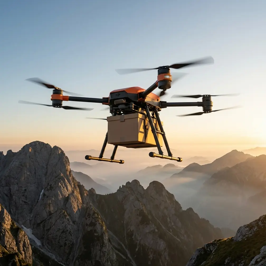
| Max Payload (Cargo Mode) | 30 kg |
| Max Payload (Winch Mode) | 40 kg |
| Max Flight Range | 16 km (with 30 kg load) |
| Max Wind Resistance | 12 m/s |
| Operating Temperature | -20°C to 45°C |
| Battery System | Dual-battery redundant |
| Emergency System | Integrated parachute |
| IP Rating | IP55 |
| Navigation | Multi-GNSS + RTK |
The payload ratio here is critical. At roughly 31.6% useful load to total takeoff weight, the FlyCart 30 sits at the top of its class for commercial heavy-lift drones. That ratio means you're carrying meaningful inspection payloads—LiDAR rigs, multispectral sensor arrays, soil sampling kits—not just lightweight cameras.
Field Performance: What I Learned After 60+ Sorties
Payload Delivery and Sensor Placement
Last season, our team was tasked with deploying soil moisture sensors across 2,400 hectares of remote farmland in Montana. The fields sat beyond paved road access, separated by creek crossings that had flooded after spring melt. Previous years, this job took a crew of four roughly eight working days.
With the FlyCart 30, we completed the entire deployment in three days with a two-person team.
The winch system was the decisive factor. Rather than landing the drone at each waypoint—which risks rotor wash disturbing soil conditions and demands cleared landing zones—we used the 20-meter winch cable to lower sensor packages directly to GPS-marked coordinates. The winch offers controlled descent rates and automatic load-release confirmation, so the operator maintains full situational awareness throughout the drop.
Expert Insight: When using the winch system for sensor deployment, pre-rig your payloads with standardized quick-release hooks rated above your package weight. We used 40 kg-rated carabiner clips even for 8 kg sensor packages. The margin matters when wind gusts create dynamic loading on the cable.
BVLOS Route Optimization
The FlyCart 30 supports BVLOS operations when paired with DJI's flight planning infrastructure and appropriate regulatory approvals. For remote field inspections, this capability transforms your operational geometry.
Instead of setting up multiple launch points across a survey area, you can:
- Program sequential waypoint delivery routes from a single base
- Set altitude profiles that adapt to terrain elevation changes
- Build in automated return-to-home triggers based on battery thresholds
- Overlay inspection grids with sub-meter RTK positioning accuracy
- Monitor live telemetry across the full 16 km operational range
Route optimization isn't just about convenience. On our Montana project, consolidating to a single launch point eliminated three vehicle repositions per day, saving roughly 90 minutes of non-productive time per session.
Dual-Battery Redundancy in Practice
The dual-battery architecture on the FlyCart 30 isn't merely about extending flight time. It's a genuine safety system.
Each battery operates on an independent power bus. If one battery fails—whether from cell damage, a thermal event, or a connection fault—the remaining battery sustains flight long enough for a controlled landing or return-to-home execution.
During field inspections in remote areas, this redundancy carries operational significance that goes beyond safety compliance. A crashed drone 20 km from the nearest road isn't just a hardware loss. It's a mission failure that could delay an entire project timeline by weeks.
Pro Tip: Rotate your battery pairs systematically. Label each pair and log cycle counts per pair, not per individual battery. Mismatched cycle counts between paired batteries can lead to uneven discharge rates, reducing effective redundancy. We retired pairs at 200 cycles regardless of individual battery health indicators.
Comparing the FlyCart 30 to Alternative Platforms
How does the FlyCart 30 stack up against other methods of getting inspection equipment into remote fields?
| Factor | FlyCart 30 | Helicopter Charter | ATV Ground Transport | Lighter Drones (<10 kg) |
|---|---|---|---|---|
| Payload Capacity | 30-40 kg | 200+ kg | 100+ kg | 2-5 kg |
| Setup Time | ~15 minutes | Hours (scheduling) | 30-60 min per site | ~10 minutes |
| Terrain Independence | Full | Full | Limited by trails | Full |
| Operating Cost per Sortie | Low | Very High | Moderate | Very Low |
| Precision Placement | Sub-meter (RTK) | Low | Variable | Sub-meter |
| Weather Sensitivity | Moderate | High | Low | High |
| Regulatory Complexity | Moderate (BVLOS waiver) | High | Low | Low-Moderate |
The FlyCart 30 occupies a specific operational sweet spot: payloads too heavy for standard survey drones, in locations too remote or too cost-prohibitive for manned aviation, across terrain too rough for ground vehicles.
Inspection Workflow: Step-by-Step
Here's the workflow our team refined over the course of the Montana deployment and subsequent projects.
Pre-Mission Planning
- Survey the target area using satellite imagery and available elevation data
- Identify waypoints for sensor placement or inspection stops
- Build the flight route in DJI Pilot 2 or DJI FlightHub 2, accounting for terrain altitude variations
- Calculate battery requirements based on total route distance, payload weight, and expected wind conditions
- File for regulatory approvals (BVLOS waivers, airspace coordination) well in advance
Field Execution
- Establish the launch site on stable, level ground with clear vertical clearance
- Perform pre-flight checks: battery health, propeller torque, winch cable integrity, GNSS lock status
- Load the payload and verify center-of-gravity alignment
- Execute the programmed route with a dedicated visual observer if required by your operational approval
- Monitor telemetry continuously—battery voltage, motor temperatures, wind speed at altitude
- Confirm each delivery or inspection point via the winch system's load-release feedback
Post-Mission
- Download flight logs for compliance records and operational analysis
- Inspect the airframe for debris impact, cable wear, or propeller edge damage
- Charge and cycle batteries according to your rotation schedule
- Debrief the team on any anomalies for continuous improvement
Common Mistakes to Avoid
Ignoring wind conditions at altitude. Ground-level wind readings can differ dramatically from conditions at 50-100 meters AGL. The FlyCart 30 handles 12 m/s winds, but a 30 kg payload acts as a pendulum in gusty conditions. Always check forecast winds at your planned flight altitude.
Overloading beyond rated capacity. The 30 kg cargo mode limit and 40 kg winch mode limit exist for a reason. Exceeding them degrades flight stability, accelerates motor wear, and voids your safety margins. Weigh every payload on a calibrated scale before loading.
Skipping the emergency parachute check. The integrated emergency parachute system is your last line of defense. Verify its deployment mechanism during every pre-flight. A parachute that hasn't been inspected is functionally the same as no parachute at all.
Failing to plan for battery logistics. Remote field inspections mean no charging infrastructure nearby. Calculate your total energy needs for the day and bring at least one extra battery pair beyond your planned requirement. Cold temperatures—and the FlyCart 30 operates down to -20°C—reduce effective battery capacity by 10-15%.
Neglecting regulatory lead times. BVLOS waivers and airspace authorizations take weeks or months in most jurisdictions. Starting the paperwork the week before your deployment is a guaranteed way to ground the mission before it starts.
Frequently Asked Questions
Can the FlyCart 30 carry LiDAR and multispectral sensors for field inspections?
Yes. Most commercial LiDAR units weigh between 3-12 kg, and multispectral sensor packages typically fall under 5 kg. The FlyCart 30's 30 kg payload capacity in cargo mode accommodates these sensors along with mounting hardware, data loggers, and supplementary batteries for the sensors themselves. The key consideration is securing the payload so it doesn't shift during flight—use foam-lined cargo containers or custom mounting brackets.
How does the FlyCart 30 handle operations in rain or dusty field conditions?
The FlyCart 30 carries an IP55 rating, meaning it's protected against water jets from any direction and limited dust ingress. Light to moderate rain and dusty agricultural environments are within its operational envelope. Heavy downpours, standing water landings, and sandstorm-level particulate exposure are not. After operating in dusty conditions, clean the motor ventilation openings and inspect propeller leading edges for abrasive wear.
What regulatory approvals are needed for BVLOS field inspection flights?
Regulatory requirements vary by country and jurisdiction. In the United States, BVLOS operations require a Part 107 waiver from the FAA, which involves demonstrating risk mitigation strategies including detect-and-avoid capability, communication redundancy, and emergency procedures. Some operators also need coordination with local agricultural aviation and airspace managers. Budget 60-120 days for the approval process and consult with a certified remote pilot who has BVLOS waiver experience.
Ready for your own FlyCart 30? Contact our team for expert consultation.