FlyCart 30 Guide for Forest Inspection in Extreme Temperatur
FlyCart 30 Guide for Forest Inspection in Extreme Temperatures
META: A field-driven FlyCart 30 guide for forest inspection in extreme temperatures, covering payload ratio, dual-battery reliability, winch use, BVLOS planning, route optimization, and practical image-capture discipline.
When people discuss forest inspection drones, the conversation usually starts in the wrong place. Too much attention goes to headline specs, not enough to what actually keeps an operation productive when the temperature swings hard, visibility changes by the hour, and your team is trying to cover large wooded areas without repeated site access.
That is where the FlyCart 30 becomes interesting.
I’m writing this from the perspective of logistics, not marketing. In forest work, especially in remote or temperature-stressed environments, the drone is not just an aircraft. It is part transport platform, part sensor delivery system, part time-management tool. If it cannot move equipment into difficult terrain, hold stable procedures across repeated missions, and support image collection that operators can trust, it creates more field friction than value.
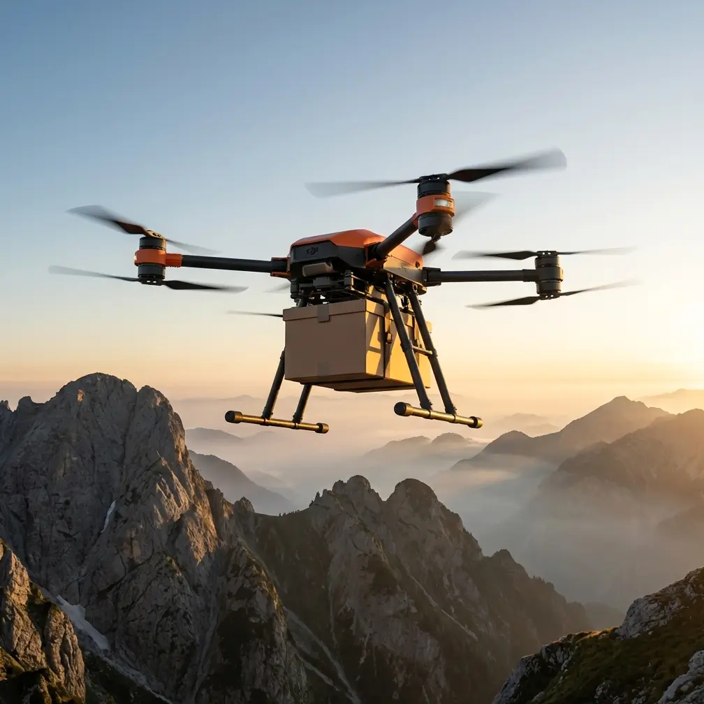
The FlyCart 30 stands out because it is built around real payload work rather than lightweight inspection assumptions. That difference matters more in forests than many teams realize.
Why forests in extreme temperatures expose weak drone planning
Forest inspection sounds straightforward until the conditions start stacking up. Dense canopy. Irregular landing zones. Wind corridors. Cold mornings, hot afternoons. Long stand-off distances. Limited road access. Battery performance that shifts with ambient temperature. Crews carrying extra tools because one aircraft rarely solves every problem.
In those conditions, the platform with the best brochure does not always win. The one with the best payload ratio and deployment logic often does.
A forest inspection mission may involve more than camera flights. Teams may need to deliver sensors, sample kits, communication devices, spare batteries, or light support equipment to technicians positioned away from vehicle access. If the aircraft can inspect and support the operation logistically, the workflow compresses. That is where the FlyCart 30 has an edge over many competitor platforms that are competent at imaging but far less capable once the mission asks them to carry meaningful weight.
This is why the payload ratio discussion is not academic. In practical terms, a stronger payload-capable drone lets one aircraft cover roles that would otherwise require a separate transport system or repeated hikes by ground crews. For a forest operator dealing with extreme temperatures, fewer redeployments means less exposure, less battery waste, and tighter route control.
The FlyCart 30 is not just about lifting weight
The easy way to describe the FlyCart 30 is to call it a cargo drone. That is incomplete.
For forest inspection, its real value is that lifting capability changes how you design the whole mission. You can move from a simple “fly and observe” model to a layered operation:
- inspect a corridor or compartment,
- deliver a tool or replacement device,
- lower equipment into a clearing with the winch system,
- support remote crews without forcing a full ground detour,
- return on a planned route with less idle time.
That is a very different operational profile from smaller systems that can gather imagery but have no useful margin once weather, terrain, and support gear enter the equation.
The winch system deserves special attention here. In forests, the problem is often not whether the drone can reach the point of interest. The problem is whether it can safely transfer an item without needing a clean landing zone. Dense vegetation, uneven ground, mud, snow, or steep slopes make landing unrealistic in many inspection scenarios. A winch solves that by turning vertical access into a controlled handoff process. Operationally, that reduces landing risk and keeps the aircraft clear of obstacles near the ground.
For forestry teams checking sensor nodes, trail infrastructure, monitoring stations, or remote communications gear, that matters a lot.
Extreme temperatures make power management a planning discipline
The dual-battery architecture is one of the most practical advantages for this kind of work.
Extreme temperatures punish weak power planning. In cold conditions, battery efficiency drops and available performance can become less predictable. In hotter environments, thermal stress affects turnaround pace and flight scheduling. A drone platform designed for more resilient power management gives operators more confidence in route planning and contingency decisions.
With the FlyCart 30, dual-battery thinking is not just about redundancy on paper. It supports steadier mission design. In forest inspection, that translates into three concrete benefits:
1. Better confidence on outbound legs
When flying into a remote wooded zone, crews need to know the power system can support both the task and the return profile with margin. This becomes even more critical in BVLOS-style planning where direct visual proximity is limited and route discipline must be tighter.
2. Less operational disruption during support tasks
If the aircraft is not only inspecting but also carrying payloads or using the winch, the power system is doing more work than a standard photo mission. Dual-battery design supports these mixed-role profiles better than lighter drones that were never really intended for sustained logistics duty.
3. More rational emergency planning
Forest environments are unforgiving when an aircraft has a problem. The emergency parachute adds another layer to risk management, especially over rough or inaccessible terrain. It is not a substitute for proper route planning, but it changes the way operators think about worst-case scenarios in a meaningful way.
Compared with competitors focused mainly on imaging, the FlyCart 30 excels because its architecture is built for transport-grade mission stress, not just sensor-grade flight.
Route optimization is where the real efficiency shows up
A lot of teams underestimate how much productivity is lost before takeoff. Poor route sequencing, unnecessary repositioning, bad drop-point logic, and repeated site visits can erase the benefits of even an excellent aircraft.
For forest inspection, route optimization with the FlyCart 30 should be built around mission clustering.
Instead of treating each task as separate, combine them:
- visual inspection of a stand boundary,
- thermal or condition-check pass over selected assets,
- payload delivery to a remote point,
- winch drop to avoid landing,
- return leg aligned with terrain and weather shifts.
That approach cuts deadhead flight time and reduces crew fatigue on the ground.
If you are operating in temperature extremes, route design should also reflect time-of-day performance windows. Morning flights may offer better stability in some regions, while midday heat can force more conservative payload planning. In colder regions, the reverse can be true if early conditions are too harsh on batteries and field staff. The FlyCart 30 gives you enough mission flexibility to plan around those windows rather than simply accept them.
This is also where BVLOS workflows become strategically valuable. Forest properties are often too large or too obstructed for frequent manual repositioning to make sense. A platform suitable for extended route planning allows operators to inspect more area with fewer launch changes. The result is not just labor savings. It is cleaner data continuity.
Image quality in the field is still a human process
Here’s a useful lesson from outside the drone world. A recent technology piece published on 2026-04-15 by 御空逐影 argued that better photography is not mainly a device contest; it comes down to technique and visual discipline. That article was about mobile photography, but the principle carries directly into drone inspection.
Two of its practical tips are surprisingly relevant to forest drone operations.
The first: clean the lens with a soft cloth before shooting. It sounds almost too basic to mention, but in field drone work it is operationally significant. Forest inspections in extreme temperatures often involve condensation risk, dust, pollen, moisture residue, and fingerprints during sensor swaps or preflight handling. If your optics are dirty, your expensive aircraft and carefully planned route are producing compromised data. That is not a camera problem. It is a process problem.
The second: reduce avoidable disturbances when capturing natural scenes. The smartphone article referenced turning off shutter sound to make candid shots more natural. In drone terms, the equivalent is minimizing operational behaviors that disturb the environment or the crew’s workflow unnecessarily. That can mean using the winch instead of landing near sensitive ground zones, selecting hover positions that avoid startling nearby workers, or planning passes that preserve the natural state of what you are documenting. Forest inspection quality depends on observing conditions as they are, not as your aircraft forces them to become.
That photography article mentioned a set of 100 tips spanning preparation and scenario-based shooting. The takeaway for FlyCart 30 operators is simple: image capture quality starts before takeoff. Preflight optics checks, environmental awareness, and disciplined capture procedures often matter as much as the aircraft itself.
A practical how-to workflow for FlyCart 30 forest inspection
Here is the framework I recommend.
Step 1: Define whether the mission is pure inspection or inspection plus support
This single decision affects payload selection, battery margin, route length, and drop strategy. If the mission includes transporting a device, sample container, or replacement part, build the route around the payload first, not as an afterthought.
Step 2: Match payload ratio to terrain difficulty
In forests, heavier payloads are not just heavier. They can force lower flexibility in route adjustments once weather or wind shifts. The FlyCart 30 gives more usable headroom than many competing drones, which is exactly why it performs so well in mixed inspection-logistics roles.
Step 3: Use the winch system wherever landing quality is uncertain
Do not force landings into brush, uneven clearings, or snow-softened surfaces if the task can be completed by controlled lowering. The winch is not just convenient. It reduces touchdown risk, saves time, and protects the aircraft from avoidable ground interaction.
Step 4: Build temperature margin into every leg
Do not plan routes using ideal-condition assumptions. In extreme temperatures, conservative battery logic is not optional. Dual-battery capability helps, but it does not excuse optimistic planning.
Step 5: Prepare optics like a survey instrument
Use a soft cloth. Clean before every sortie. This may sound borrowed from basic phone photography advice, but it has direct operational value. One fingerprint can soften detail enough to undermine inspection records.
Step 6: Plan for emergency recovery before launch
The emergency parachute is a safety layer, not a mission strategy. Know where a descent would create the least ground impact and how the team will respond in terrain with limited access.
Step 7: Review route optimization after every mission
The best FlyCart 30 operations improve fast because they treat routing as a living system. Compare planned versus actual flight time, payload handling delays, hover inefficiencies, and weather-driven deviations.
If your team is refining those workflows in difficult terrain, it can help to message a field specialist here and compare setup logic against real forest-use cases.
Where FlyCart 30 clearly outperforms lighter competitors
Many drones can inspect. Fewer can inspect while carrying the mission.
That is the practical dividing line.
A lighter competitor may do a fine job collecting visuals on a short route in mild conditions. But once the operation involves extreme temperatures, remote access, uneven terrain, support deliveries, or repeated equipment handoff, those platforms often become single-purpose tools. The FlyCart 30 remains useful because it was designed with transport strength at its core.
That shows up in four ways:
- stronger payload ratio for mixed-role missions,
- winch-enabled operations where landing is impractical,
- dual-battery confidence in tougher environmental windows,
- emergency parachute support for better risk posture in remote terrain.
For forest inspection teams, that means one aircraft can replace a patchwork workflow. And in real operations, reducing workflow fragmentation is often more valuable than adding another isolated feature.
Final field perspective
The FlyCart 30 makes the most sense when you stop thinking of it as only a cargo platform and start seeing it as a forest operations tool. In extreme temperatures, that distinction matters. A drone that can carry useful payloads, support route discipline, avoid bad landings through a winch, and hold a stronger safety posture gives crews options they do not get from inspection-only systems.
And the small things still matter. Clean optics. Thoughtful capture behavior. Good preparation. The same lesson highlighted in that 2026-04-15 photography article applies here too: results come from technique, not just hardware. In drone forestry, disciplined execution turns a capable platform into a dependable one.
Ready for your own FlyCart 30? Contact our team for expert consultation.