FlyCart 30 in Forest Inspection: A Field Report on What
FlyCart 30 in Forest Inspection: A Field Report on What Actually Matters in Complex Terrain
META: Field-tested insights on using the FlyCart 30 for forest inspection in complex terrain, with practical notes on flight altitude, winch use, BVLOS planning, payload ratio, dual-battery operations, and safety systems.
I spend a lot of time looking at aircraft specifications and an equal amount of time watching those specifications get humbled by the field. Forest inspection is one of those environments that exposes the difference immediately. On paper, a drone may look capable. In steep valleys, under broken canopy, with wind curling off ridgelines and GPS behaving inconsistently near cliffs, the useful question changes. It is no longer “What can this aircraft carry?” but “What can it do reliably, repeatedly, and safely over a full workday?”
That is the right lens for the FlyCart 30.
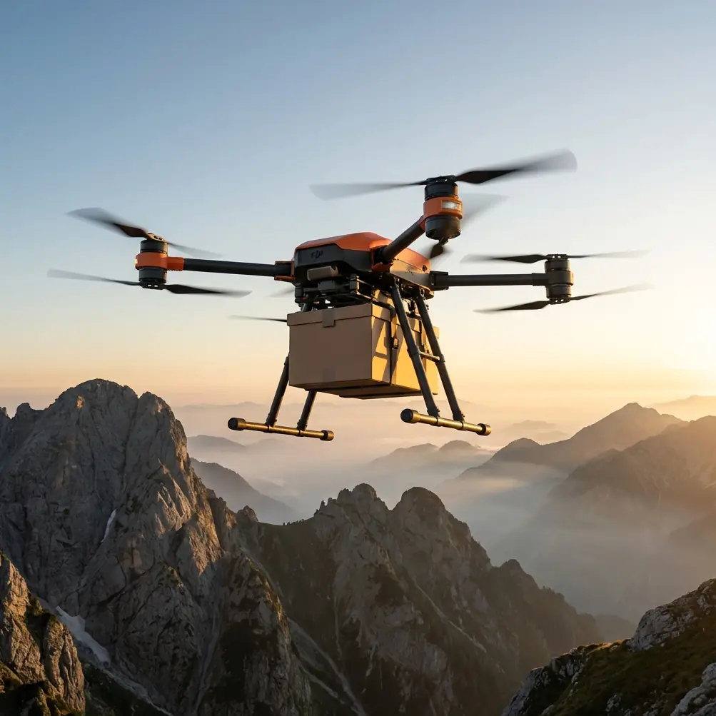
Most people associate the FC30 with transport. Fair enough. But in difficult forestry work, especially in mountainous or fragmented terrain, its value is not limited to moving materials. The platform’s relevance comes from how it manages risk, endurance, and access in places where ground teams lose hours just getting into position. Inspection work in forests often involves sensor placement, sample delivery, relay of tools, line deployment, emergency resupply to crews, and repeated route verification over uneven elevation. That is where a heavy-lift logistics drone starts to become an inspection asset rather than just a carrier.
There is a bigger industry context behind this. A recent report cited foreign estimates suggesting China’s monthly drone production sits around 700,000 units, while also arguing that figure understates actual manufacturing capacity. The source did not provide a detailed methodology, model breakdown, or an authoritative statistical basis, so I would not treat that number as a clean benchmark. Still, the operational significance is real. When output at that scale is even being discussed, it tells you something about ecosystem maturity: supply chains are broad, subsystem development is deep, and industrial drone adoption is no longer a niche experiment. For operators considering the FC30 for forestry inspection, that matters because aircraft capability is only half the equation. Battery availability, repair logistics, training throughput, accessory support, and platform continuity are what make a drone useful beyond a demo flight.
In forest operations, continuity is everything.
Why the FlyCart 30 fits forest inspection better than many “inspection drones”
A pure imaging aircraft can document a stand of trees, a power corridor through woodland, or a slope instability zone. But forests are rarely just about eyes in the sky. Crews need to get things into and out of hard-to-access sites. One day it is a compact sensor package. The next, it is a line throw kit, first-aid supplies, replacement field instruments, or sample containers. Inspection becomes logistics very quickly.
That is where payload ratio starts to matter.
A strong payload ratio changes mission design because it gives you margin. In complex terrain, margin is what keeps an operation practical. You may need to launch from a suboptimal clearing rather than a perfect flat pad. You may need to climb aggressively after takeoff to clear nearby tree lines. You may need to preserve reserve power for unexpected rerouting when valley winds strengthen. An aircraft with enough carrying headroom is not simply “stronger”; it is more adaptable when the environment starts making decisions for you.
The FC30’s winch system is another reason it makes sense in the forest. This is not an accessory to admire in a brochure. It solves a very specific field problem: many forest inspection points do not justify landing, and some should not be landed on at all. You may be working above fragile understory, unstable slopes, muddy extraction sites, or narrow breaks in canopy where rotor wash would be undesirable. Lowering gear by winch lets the aircraft stay clear of branches and terrain while still delivering exactly what the team needs. For sensor deployment and retrieval, that is often cleaner than trying to force a landing into a compromised area.
The winch also reduces one of the hidden costs in forestry drone operations: site preparation. If your crew has to cut, clear, or manually stabilize micro-landing zones throughout the day, the aircraft may be technically capable but operationally inefficient. Hover, lower, release, recover, move on. That sequence is what saves time.
My preferred altitude logic for forests: higher than the canopy, lower than your confidence
The question I get most from teams preparing to inspect forests with the FC30 is flight altitude. They usually want a single answer. There isn’t one. But there is a pattern that works.
For transit over complex forest terrain, I generally prefer maintaining a working altitude around 40 to 60 meters above the highest nearby canopy or obstacle line, then adjusting upward near ridgelines and narrowing valleys. Not because higher is always safer. It is because this band tends to balance three competing realities: obstacle clearance, wind exposure, and winch accuracy.
Fly too low and you invite trouble from emergent trees, dead snags, and terrain-induced turbulence that is difficult to read from the ground. Fly too high and you may improve clearance but lose precision during payload lowering, especially if the operation depends on stable placement into small openings. In many mountain forests, once you climb excessively above the canopy, you also meet stronger crosswinds and more pronounced drift during hover. That becomes a problem when you are dropping equipment to crews or placing devices near marked inspection points.
So my rule is simple: transit with vertical margin, but do not turn altitude into a substitute for route planning.
Ridgeline crossings deserve special attention. Add height before the ridge, not over it. Mechanical turbulence often increases as you crest, and trying to climb late while carrying a payload is a poor habit. In gullies and valley routes, avoid the temptation to follow terrain too tightly. The shortest path through a forested ravine is often the least forgiving one.
BVLOS only works when the route is smarter than the pilot
Forests are one of the clearest cases for BVLOS operations because the distances are long and line-of-sight is broken constantly by topography. But BVLOS is not a magic word. In practice, it is a discipline of route optimization.
The FC30 is useful here because its mission value does not depend on improvisation midair. You can build repeatable corridors for supply and inspection support. Once the route is known, documented, and stress-tested, the operation becomes less about pilot heroics and more about process control.
I like to break forest BVLOS route planning into three layers:
1. Terrain layer
Study elevation transitions first, not last. Forest maps can hide how punishing the vertical profile really is. A route that looks efficient on a top-down screen may force repeated climbs and descents that consume unnecessary energy.
2. Canopy and obstacle layer
Tree height is never as uniform as the map suggests. Fire scars, regrowth zones, utility cut paths, towers, and isolated snags all alter the safe envelope. Build the route around the highest-risk sections rather than the average sections.
3. Task layer
Where exactly will the aircraft hover? Where will the winch deploy? Where are crews likely to stand? Inspection success often depends less on getting near the site than on approaching it from an angle that keeps the aircraft stable while the load descends.
This is where route optimization and payload ratio connect. If you optimize the route to reduce power-hungry altitude changes and avoid hover in messy wind pockets, you preserve battery margin. More battery margin means more real payload flexibility, or more reserve for safe return. Operators often treat these as separate planning domains. They are not.
Dual-battery thinking is not just about endurance
A lot of teams see dual-battery architecture and think only in terms of longer flight time. That is too narrow. In forest inspection, dual-battery logic is really about resilience.
Resilience matters because the job environment compounds uncertainty. Cold mornings, damp air, elevation changes, repeated climbs, hover time during winch deployment, and route deviations all put pressure on the energy plan. A dual-battery setup helps smooth that pressure, but just as importantly, it changes how conservatively you can operate. You can keep healthier reserve thresholds. You can avoid flying batteries deeper into discharge just to complete one more drop. You can plan around safe return instead of optimistic completion.
That translates directly into better field behavior. Teams with energy margin tend to make better decisions. They are more willing to wave off a difficult hover. They reroute earlier. They do not press a mission because the battery picture is already tight.
In forests, discipline beats ambition.
Emergency parachute: not a headline feature, a forest feature
I would never base an aircraft choice solely on an emergency parachute. But in forest inspection, it deserves more respect than it usually gets.
When you operate around steep terrain, scattered crews, and limited access roads, recovery from an incident is harder than in open farmland or industrial yards. An emergency parachute is operationally significant because it adds a layer of consequence reduction in a place where every bad outcome is harder to contain. Dense woodland does not make emergencies gentler. It makes them more complicated.
The practical value is also psychological. Safety systems tend to improve planning culture when teams take them seriously. Pilots become less casual about route reviews, weather checks, and exclusion zones when they understand the aircraft as a managed risk platform rather than an indestructible workhorse.
A real field rhythm for FC30 forest work
If I were running the FC30 on a forest inspection support mission, the day would probably look like this:
First sortie: high-confidence route verification. Light payload, conservative speed, confirm terrain effects and hover points.
Second sortie: deliver field sensors or inspection tools via winch to the first work crew. Maintain enough altitude above canopy to avoid surprise branches, then descend only into the hover profile needed for deployment.
Third sortie onward: repeat along preplanned points, adjusting routes based on observed wind channels and crew feedback.
The key is not to chase maximum utilization in the morning. Forests reveal their patterns slowly. Once you understand where the wind shears sit and where the hover gets messy, then you can tighten the workflow.
For teams building their first FC30 forestry program, I usually recommend documenting not just flight paths but hover outcomes: drift rate, load swing behavior, descent stability, and crew pickup times. That becomes your actual operational database. If you want a practical discussion around setup logic and field workflow, I’d use this direct planning channel: message the operations desk.
What the manufacturing story means for operators
Let’s go back to that production narrative for a moment. The reported estimate of 700,000 drones per month, paired with the claim that true capacity is even higher, should not be read as a neat data point. The source itself lacked a clear statistical framework. But it does highlight something useful for FC30 buyers and operators: the drone industry is now operating at a scale where infrastructure around the aircraft may determine success as much as the aircraft itself.
For a forestry team, that means asking practical questions. Can your operation secure a stable battery rotation plan? Can maintenance support keep downtime acceptable during peak inspection season? Can your pilots train consistently enough to standardize winch deployment and route execution? Industrial drone success comes from those systems. The aircraft is the centerpiece, not the whole machine.
That is why the FC30 stands out in forestry support. Not because it is a generic “big drone,” but because its feature set aligns with the ugly details of real fieldwork: awkward access, no clean landing zone, changing elevation, repeated payload handling, and safety demands that do not disappear when the mission is routine.
If your forest inspection work includes moving equipment, placing devices, supporting crews in steep terrain, or maintaining repeat routes into difficult areas, the FC30 deserves to be evaluated as an operational platform rather than a transport novelty. The difference becomes obvious the moment you stop reading the spec sheet and start planning the day.
Ready for your own FlyCart 30? Contact our team for expert consultation.