FlyCart 30 for Mountain Power Line Work: The Pre
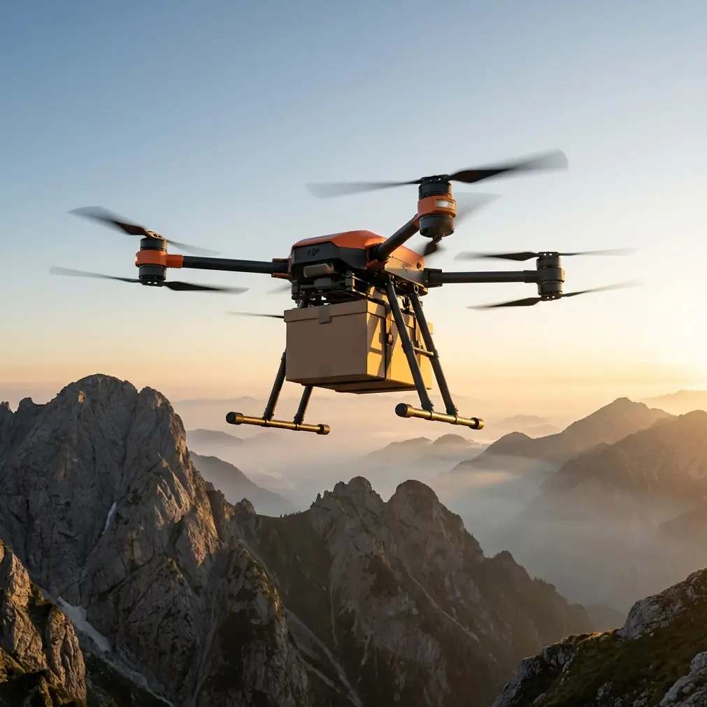
FlyCart 30 for Mountain Power Line Work: The Pre-Flight Habits That Prevent Expensive Mistakes
META: A practical FlyCart 30 guide for mountain power line inspection teams, focused on pre-flight checks, lens cleaning, stability, winch use, BVLOS planning, dual-battery discipline, and safer route execution.
Mountain power line inspection looks glamorous from a distance. In the field, it is mostly discipline.
Wind changes shape as it wraps around ridgelines. Light shifts fast. Access roads disappear into washouts or narrow turns. A crew may be asked to document insulators, towers, vegetation encroachment, and hardware conditions across long stretches where every extra landing costs time. That is where the FlyCart 30 starts to make sense—not as a generic heavy-lift drone, but as a working aircraft for crews that need to move tools, support inspection tasks, and operate with method rather than improvisation.
I lead logistics teams, and if there is one habit I insist on before mountain missions, it is this: clean the critical optics and sensors before takeoff.
That sounds almost too basic. It is also where many avoidable problems begin.
A recent photography piece aimed at beginners made a point that applies surprisingly well to industrial drone work: poor image quality often comes from neglected basics, not weak hardware. It singled out fingerprints and oil smudges on a lens as a major cause of glare, blur, and loss of detail. The suggested fix was simple—wipe the lens with a clean cloth before shooting. For phone photography, that means better pictures. For a FlyCart 30 team inspecting mountain power lines, it can mean the difference between a usable visual record and a second flight in worsening conditions.
That same source emphasized stability: hold with both hands, keep elbows close, and use nearby support in low light to reduce blur. On the surface, that sounds like advice for casual photography. In practice, it maps directly to how professional crews should think about drone prep and mission execution. Stable platforms produce cleaner information. Clean optics preserve detail. Small habits protect mission value.
This guide is built around that idea.
Start with the simplest pre-flight item: clean what the aircraft relies on to see
When crews talk about pre-flight safety, they usually jump straight to batteries, weather, propellers, airspace, or route setup. Those matter, obviously. But in mountain utility work, visual integrity is one of the first things to degrade and one of the last things some teams check properly.
If the aircraft camera, auxiliary optics, or any exposed visual sensing surface carries fingerprints, dust film, oil residue, or moisture marks, three things happen fast:
- Fine details on conductors, fittings, and attachment hardware become harder to verify.
- Sun angle creates extra glare and washout.
- The crew loses confidence in the output and starts compensating with more hovering, more repositioning, and more battery burn.
That is a bad trade.
A clean cloth takes seconds. A repeat sortie over mountain terrain does not.
On a FlyCart 30 mission supporting power line work, I recommend making optical cleaning a written line item, not an informal habit. The pre-flight sequence should include the camera lens and any exposed sensing windows involved in navigation or safety functions. The operational significance is straightforward: if the aircraft’s “view” is compromised before launch, route precision, obstacle awareness, and inspection image quality all start from a lower baseline.
That is especially relevant when teams are working near slopes, towers, or uneven terrain where visual confidence helps the pilot and observers make better decisions.
Why this matters more in the mountains than in flatland work
Mountain utility inspection is unforgiving because the environment multiplies minor errors.
A dusty lens in a flat, open corridor may still deliver enough clarity to finish the task. In steep terrain, the same contamination can turn contrast-heavy scenes into something much less readable. Snow patches, bare rock, reflective hardware, and backlit conductor lines all compete in the image. Smudges amplify flare. Detail drops out. The crew starts chasing angles instead of executing the plan.
The result is rarely dramatic in a single moment. It is cumulative.
The aircraft hovers longer than expected. The payload ratio of the mission shifts in a subtle way: less of the available capacity is creating useful work, and more of it is being consumed by correction, repositioning, and redundant passes. That matters on FlyCart 30 operations because every battery cycle and every minute aloft should serve the route objective, not recover from preventable quality loss.
The same logic applies to the winch system. If your mission includes lifting a compact inspection kit, spare sensors, tools, or communication gear to a ridge location, the aircraft is doing more than flying a camera. It is extending the reach of the team. Once you ask the platform to carry both operational equipment and the burden of inefficiency, the margin gets thinner.
Build a “steady capture” mindset into the whole operation
The reference article’s second lesson was stability. For phone users, it suggested using both hands, elbows tight to the body, and fixed supports such as walls or railings in low light. For a drone crew, the equivalent is not physical handholding. It is operational steadiness.
That means:
- don’t rush takeoff after setup
- don’t launch with a half-formed route
- don’t hover manually for too long where an optimized flight path would do better
- don’t ask the aircraft to fight unnecessary drift while you decide what comes next
Mountain power line inspection rewards a calm sequence. Confirm route optimization before liftoff. Choose holding points intentionally. Use terrain-aware planning. If the aircraft will support a drop or pickup through the winch system, rehearse the exact hover profile and ground team timing before launch.
Stability in this context protects both image quality and flight efficiency.
Low-light periods are a good example. Early morning and late afternoon often produce useful visual contrast on towers and lines, but they also expose weak crew habits. If a team has not planned stable observation points and efficient camera angles, they may spend too long hovering in variable air. That increases the chance of blurred imagery, wasted battery, and awkward control inputs near terrain.
The photography source framed this simply: in low light, unsupported shooting leads to blur. For FlyCart 30 work, the translation is just as simple: if conditions demand steadiness, design steadiness into the mission instead of improvising it in the air.
Dual-battery discipline is not just about endurance
The FlyCart 30’s dual-battery setup is often discussed in terms of flight duration and operational continuity. Fair enough. But for mountain inspection work, I look at it differently: dual-battery systems should buy decision space, not bad habits.
A crew that assumes extra power will absorb loose planning often ends up spending that margin on avoidable corrections. Poor optical prep. Weak route design. Hovering to troubleshoot. Returning for a better image because the first set was compromised by something as mundane as a dirty lens.
This is where basic fieldcraft and aircraft capability meet.
The source material argued that many beginners blame hardware for problems caused by overlooked basics. That diagnosis lands cleanly here. Operators sometimes blame terrain, wind, or camera limitations for soft or hazy inspection results when the root issue was pre-flight neglect. If your camera surface was dirty from transport, handling, or the last battery swap, the aircraft never had a chance to produce its best output.
On a mountain mission, preserving dual-battery margin means preserving options:
- one more inspection pass on a suspicious fitting
- one more transport cycle with the winch system
- one cleaner return corridor if wind strengthens
- one safer reserve buffer for terrain and altitude variables
Those options are valuable. Do not trade them away for a microfiber cloth you forgot to use.
The winch system changes how inspection crews can stage mountain work
The FlyCart 30 becomes especially useful around utility corridors when the mission is not limited to “fly out and look.” Mountain crews often need to reposition small but essential items: a lightweight toolkit, sensor pack, field radio, rope, replacement consumables, or emergency support gear for a line team working beyond vehicle reach.
That is where the winch system matters operationally.
Instead of forcing personnel to traverse difficult ground for every item exchange, the aircraft can support more intelligent staging. A ridge team receives what it needs without a full relocation. Inspection and maintenance support begin to merge into one workflow. The route can be optimized around both observation and delivery tasks rather than treating them as separate operations.
But that only works if crews respect pre-flight detail. A dirty optical system during a winch mission creates a chain reaction: reduced visual confidence at the drop point, slower alignment, longer hover time, and increased exposure to gusts near terrain. In other words, image quality is not only about documentation. It directly affects handling quality during precision support tasks.
BVLOS planning has to be cleaner than the airframe
For mountain transmission corridors, BVLOS is often discussed as the path to real productivity. That is true, but only if route design, communication procedures, and aircraft readiness are equally mature.
BVLOS does not forgive sloppy starts.
If a team launches with contaminated optics, uncertain waypoint logic, or unclear contingency roles, the aircraft may still fly. The mission just won’t run at its full standard. The farther the corridor extends and the more terrain complexity enters the picture, the more expensive those early compromises become.
This is why I recommend pairing BVLOS planning with a physical readiness check that includes:
- camera and sensor surface cleaning
- battery state confirmation
- parachute system status verification
- winch attachment and release check
- route logic review against terrain features
- emergency landing or return decision points
The emergency parachute deserves a specific note. In mountain utility work, it is part of the safety architecture, not a marketing bullet. Teams should verify its readiness with the same seriousness they bring to power checks and route planning. A disciplined pre-flight routine should never isolate safety hardware from image hardware; both contribute to safer outcomes. One protects the aircraft in a failure scenario. The other helps avoid mission drift and poor decisions before a scenario develops.
A practical pre-flight sequence for FlyCart 30 power line missions
Here is the checklist structure I use for mountain operations:
1. Clean before you configure
Before powering into the mission flow, wipe the camera lens and any exposed visual sensing surfaces with a clean cloth. The source article’s point about fingerprints and oil smudges causing glare and lost detail is not a casual photography tip here. It is a mission-quality control step.
2. Confirm payload purpose
Be explicit about what the aircraft is carrying and why. If you are using the winch system, define whether the flight is inspection-first, delivery-first, or truly mixed. This affects route shape, hover planning, and reserve margins.
3. Check dual-battery logic
Do not just confirm charge. Confirm how much margin the mission plan assumes and what triggers an early return. Mountain conditions can erase “comfortable” buffers quickly.
4. Verify parachute readiness
Treat the emergency parachute as an active part of mission safety, especially in remote terrain where recovery and third-party risk need clear thought before takeoff.
5. Optimize the route before launch
A stable operation starts on the ground. Build the route so the aircraft is not improvising at the ridgeline. If you need help validating a mountain corridor workflow, share your use case here: message our operations desk.
6. Brief stable hover and transfer procedures
If the mission includes a winch drop, pickup, or close inspection hold, define the hover point, the expected wind behavior, and the exact ground team actions. Stability is planned, not hoped for.
What separates efficient FlyCart 30 teams from average ones
Usually, it is not raw flying skill.
It is the teams that respect the tiny details without losing sight of the larger mission. They understand that a blurred image is not always a camera problem. That wasted hover time is not always a wind problem. That incomplete inspection data is not always a terrain problem.
Sometimes it started with a fingerprint.
The reference article claimed that many beginners wrongly blame the device when overlooked basics are the real issue. In industrial drone operations, the same mistake shows up in more expensive ways. A neglected lens can reduce visual confidence. Reduced confidence can produce longer holds and extra passes. Extra passes consume battery and compress reserve. Compressed reserve narrows options in mountain terrain. That is not theory. It is how routine sloppiness becomes operational risk.
The best FlyCart 30 crews break that chain at the start.
They clean first. They plan for stability. They use the dual-battery system to preserve options, not excuse inefficiency. They integrate the winch system into the route with purpose. They approach BVLOS as a structured workflow. And they verify safety systems, including the emergency parachute, as part of one coherent pre-flight standard.
That is how mountain power line work gets done properly: not by romanticizing the aircraft, but by respecting the process around it.
Ready for your own FlyCart 30? Contact our team for expert consultation.