FlyCart 30 in Mountain Power-Line Work: A Field Report
FlyCart 30 in Mountain Power-Line Work: A Field Report on Stability, Sight, and Why Optics Still Matter
META: Field report on using the FlyCart 30 for mountain power-line inspection, with practical insight on winch operations, BVLOS planning, dual-battery resilience, emergency parachute logic, route optimization, and visual payload choices.
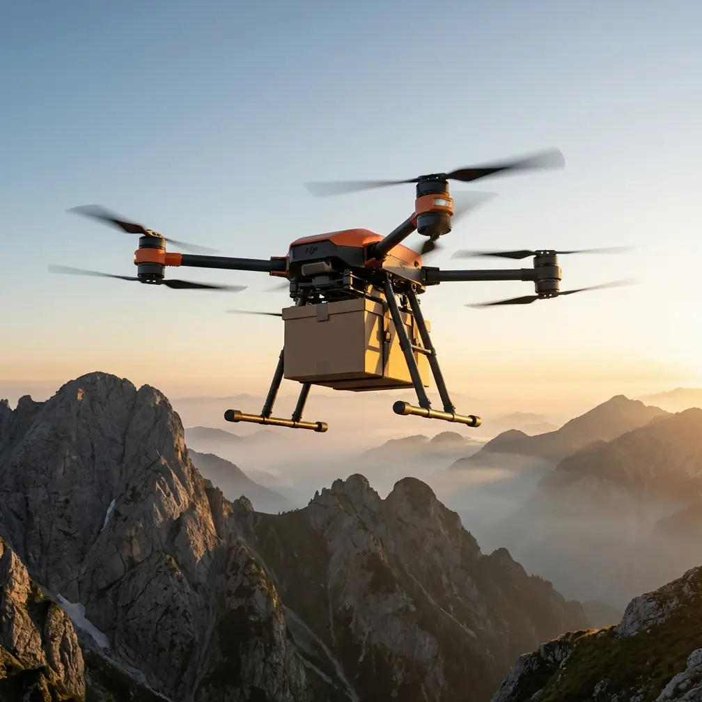
I’m Alex Kim, and most of my work lives where logistics and field reality collide. Mountain power-line inspection is a good example. On paper, it sounds straightforward: move equipment, inspect assets, gather images, get home before weather turns. In practice, it’s a stack of constraints. Terrain breaks line of sight. Wind shears across ridges. Crews burn time just reaching towers. And every extra kilogram aloft changes how much margin you have left for safety, endurance, and decision-making.
That is where the FlyCart 30 becomes interesting—not as a generic heavy-lift platform, but as a working aircraft whose value shows up when the mountain starts dictating the day.
This report centers on one job profile: power-line inspection in steep terrain. Not package drops. Not abstract capability charts. Real utility work, where the aircraft has to support a methodical operation and where every subsystem, from the winch to the emergency parachute, affects the shape of the mission.
The mountain changes the mission before takeoff
Inspection crews in flat country can often drive near structures, launch from open space, and maintain cleaner visibility throughout the flight. In mountain corridors, that rhythm falls apart. Access roads may be narrow or washed out. A tower that looks close on the map may demand a long traverse on foot. Radio conditions can shift by the minute as ridgelines mask signal paths. Even the most basic task—getting a camera into the right place—becomes a logistics problem.
That is why the FlyCart 30’s relevance starts with payload ratio and route optimization rather than image quality alone. In mountain utility work, the aircraft often has to do more than carry a camera. It may need to move tools, deliver a lightweight sensor package to a hard-to-reach slope team, or lower inspection gear precisely using the winch system so a crew can avoid climbing unstable ground. The useful question is not “How much can it carry?” but “How much mission flexibility remains after you account for altitude, weather, battery reserve, and terrain-induced inefficiency?”
A good payload ratio matters because it protects options. If the drone is operating near the edge of its practical lift capability, every adjustment in route, hover time, or descent profile becomes expensive. In power-line work, expensive usually means slower, riskier, or both.
Why the winch system matters more than many teams expect
In mountain inspection, the winch system is not a convenience feature. It is often the difference between a clean operation and a compromised one.
Landing in rough terrain is its own hazard. Loose rock, brush, side slopes, and rotor wash interactions with uneven ground all introduce variables you do not need. A winch allows the aircraft to hold position in safer air while lowering gear into a precise location. For power-line teams, that can mean placing a compact inspection kit near a structure, delivering a replacement sensor, or retrieving lightweight items without committing the airframe to a difficult touchdown.
The operational significance is simple: the winch separates delivery precision from landing precision. In mountains, those are not the same thing.
That distinction becomes even more useful when route optimization is built around staging points. Instead of flying one long profile that tries to do everything, the team can create shorter segments: launch from a road cut, lift equipment over a ridge, lower it to a receiving crew, then reposition for visual inspection along the line corridor. The FlyCart 30 works best when treated as part transport platform, part aerial access tool.
Dual-battery design is not just about endurance
Plenty of buyers look at dual-battery architecture and see only a headline about flight continuity. In mountain utility work, that misses the more important operational benefit: resilience.
When you fly around ridgelines, your mission does not unfold in laboratory conditions. Wind can force reroutes. A tower face may require more deliberate station-keeping than expected. A receiving team might need an extra minute to secure a suspended load. Those small delays stack quickly. Dual-battery configuration gives the operation more tolerance for this kind of friction.
That matters because power-line inspection is rarely a single-task mission. You may launch with visual inspection as the primary objective, then find that the crew also needs a tool delivered to a hard spot, or that weather on the far side of the slope changes your recovery plan. Dual-battery architecture helps absorb that reality. It gives planners a stronger reserve posture and gives pilots more room to stay disciplined instead of rushing the closeout phase of a flight.
In mountain work, rushed recoveries are where mistakes breed.
BVLOS planning only works if the route makes sense
BVLOS is one of those terms that gets thrown around too casually. In the mountains, beyond visual line of sight is not a badge of sophistication. It is a planning burden. If you are going to run a corridor mission responsibly, your route optimization has to be built around the terrain, not just the shortest line between points.
For the FlyCart 30, that means thinking in vertical and lateral layers. Utility corridors often snake along contours that seem efficient from above but produce poor radio geometry and awkward visual oversight from the ground. Smart route optimization considers likely signal shadows, safe loiter zones, alternate return corridors, and the actual working angle required for inspection passes. A technically shorter route may be operationally worse if it forces the aircraft into repeated ridge crossings or leaves too little margin for a stable hover near structures.
This is where logistics thinking and flight planning meet. If the team can stage batteries, personnel, and receiving points intelligently, the aircraft spends less time doing wasteful transit and more time doing useful work. That is the side of BVLOS that matters to field teams. Not the acronym. The reduction of friction.
A wildlife encounter that proved the sensors were earning their keep
One flight this spring changed how a few skeptical crew members viewed onboard sensing.
We were inspecting a mountain segment where the corridor cut across mixed forest and exposed rock. Mid-morning thermals had started to build, and visibility was good. As the aircraft moved along a planned line toward a tower approach, a large raptor lifted from a lower slope and crossed upslope toward the corridor. It was fast and not following a predictable line. For a few seconds, the encounter compressed everyone’s timeline.
The aircraft’s sensing and obstacle-awareness behavior gave the pilot enough warning to slow the profile and alter spacing without turning the moment into a dramatic event. The bird continued past and climbed above the line. We paused, reassessed, and resumed only when the airspace was clear.
That may sound minor. It wasn’t. In mountain environments, wildlife encounters are not rare edge cases. Birds of prey use the same lift bands and terrain features that drones often traverse. Sensor capability is not just about avoiding rock faces and towers; it also supports better response when the environment becomes dynamic in ways the map did not predict.
You still need disciplined pilots and observers. Sensors do not replace judgment. But in that moment, the system helped convert surprise into manageable action.
The emergency parachute changes the risk discussion
Utility operators and contractors often focus on what a drone can do when everything goes right. The better question is what happens when something goes wrong over bad terrain.
An emergency parachute is one of those features that sounds abstract until the operation takes place above slopes, trees, service roads, and energized infrastructure. Then it becomes easier to appreciate its role. It is not there to encourage aggressive flying. It exists to reduce consequences in a failure scenario where normal recovery may no longer be available.
For power-line inspection in mountain environments, that matters for three reasons.
First, access is hard. If an aircraft goes down in a remote drainage, retrieval itself can become a field risk.
Second, terrain concentrates bad outcomes. A failure near a steep rock face or dense stand of trees gives very little margin for a benign descent profile.
Third, utility work often occurs near assets you are trying not to disturb. Any mitigation layer that helps manage aircraft descent is part of a broader safety strategy.
This is why the emergency parachute belongs in the mission brief, not just the spec sheet. Crews should understand where deployment risk is acceptable, how terrain below affects outcomes, and how contingency zones are chosen before launch.
The camera question: what a portrait lens taught me about utility inspection
One of the more surprising references I keep coming back to has nothing to do with drones directly. A recent Chinese photography note described the 50mm F1.8 as the most commonly used fixed lens for portrait work. The reason was straightforward: a 50mm view looks natural and realistic, without the exaggeration of wide-angle distortion or the compressed look associated with longer focal lengths. It also highlighted the F1.8 aperture’s ability to create obvious background blur, and pointed out that this lens often costs only a few hundred to just over one thousand yuan, which is why it becomes many photographers’ first fast prime.
At first glance, that has little to do with a FlyCart 30 on a mountain line corridor. In practice, it says something useful about inspection imagery.
Operators often chase “more dramatic” visuals without asking whether the image geometry helps the maintenance decision. For human subjects, a 50mm field of view is valued because it feels natural. For infrastructure, the lesson is not that we should copy portrait settings. It is that truthful perspective matters. If a view is too wide, fittings and clearances can look distorted. If it is too compressed, spacing can be harder to interpret accurately. The best inspection image is not the one that looks cinematic; it is the one that preserves spatial relationships the engineering team can trust.
That is the operational significance of the photography reference. A natural-looking field of view can be more useful than a dramatic one when crews need to evaluate insulators, conductor attachments, vegetation encroachment, or hardware alignment. Even the mention of F1.8 has a secondary lesson. Shallow depth of field may be prized in portraits for subject isolation, but inspection work usually benefits from keeping more of the asset legible in focus. Context beats mood.
The photographers were talking about faces. The principle carries over to steel and wire: realism is productive.
Building the mission around information, not just flight time
A weak inspection workflow treats the drone as the star. A strong one treats the drone as a node in an information chain.
For the FlyCart 30, that means deciding early what each sortie is supposed to produce. Is this flight collecting visual condition data? Delivering equipment to reduce crew exposure on foot? Supporting a corridor sweep before a maintenance team moves in? Lowering a sensor package by winch to a receiving point? Each objective changes route design, reserve policy, hover behavior, and crew roles.
This is where teams often underperform. They obsess over airframe capability but fail to define the handoff. Who reviews the imagery on site? What constitutes enough evidence to avoid a repeat flight? Which tower segments justify closer station-keeping? Where are the decision gates for weather, visibility, and changing wind?
When the mountain is the operating environment, waste compounds quickly. Every unnecessary sortie burns batteries, crew attention, and daylight.
What makes the FlyCart 30 a practical fit here
The FlyCart 30 makes sense for this reader scenario because it answers several mountain inspection problems at once.
It supports a workflow where payload ratio matters because the aircraft may need to carry more than a camera.
It supports a workflow where the winch system reduces the need to land in places that should not be landing zones.
It supports a workflow where dual-battery resilience helps absorb delays that come from terrain, wind, and team coordination.
It supports a workflow where BVLOS planning is treated as disciplined route optimization rather than as a checkbox.
And it supports a workflow where safety layers—especially sensing and emergency parachute thinking—are part of the operating method, not decorative features.
If you are building or refining a mountain power-line program around the FC30, it is worth comparing your current inspection image standards, reserve policy, and staging model against the realities above. If you want to talk through corridor planning or payload setup with someone who understands the field side, you can reach us directly on this WhatsApp line.
The biggest mistake I see is assuming mountain utility work is just ordinary drone inspection with nicer scenery. It isn’t. The terrain changes access, the route changes energy use, the environment changes risk, and the mission changes what “good enough” really means. The FlyCart 30 can be a strong tool there—but only when the operation is designed around what the mountain will do to your plan.
Ready for your own FlyCart 30? Contact our team for expert consultation.