FlyCart 30: Remote Wildlife Inspection Made Easy
FlyCart 30: Remote Wildlife Inspection Made Easy
META: Learn how the DJI FlyCart 30 transforms remote wildlife inspection with its winch system, dual-battery endurance, and BVLOS capability for field teams.
By Alex Kim, Logistics Lead
TL;DR
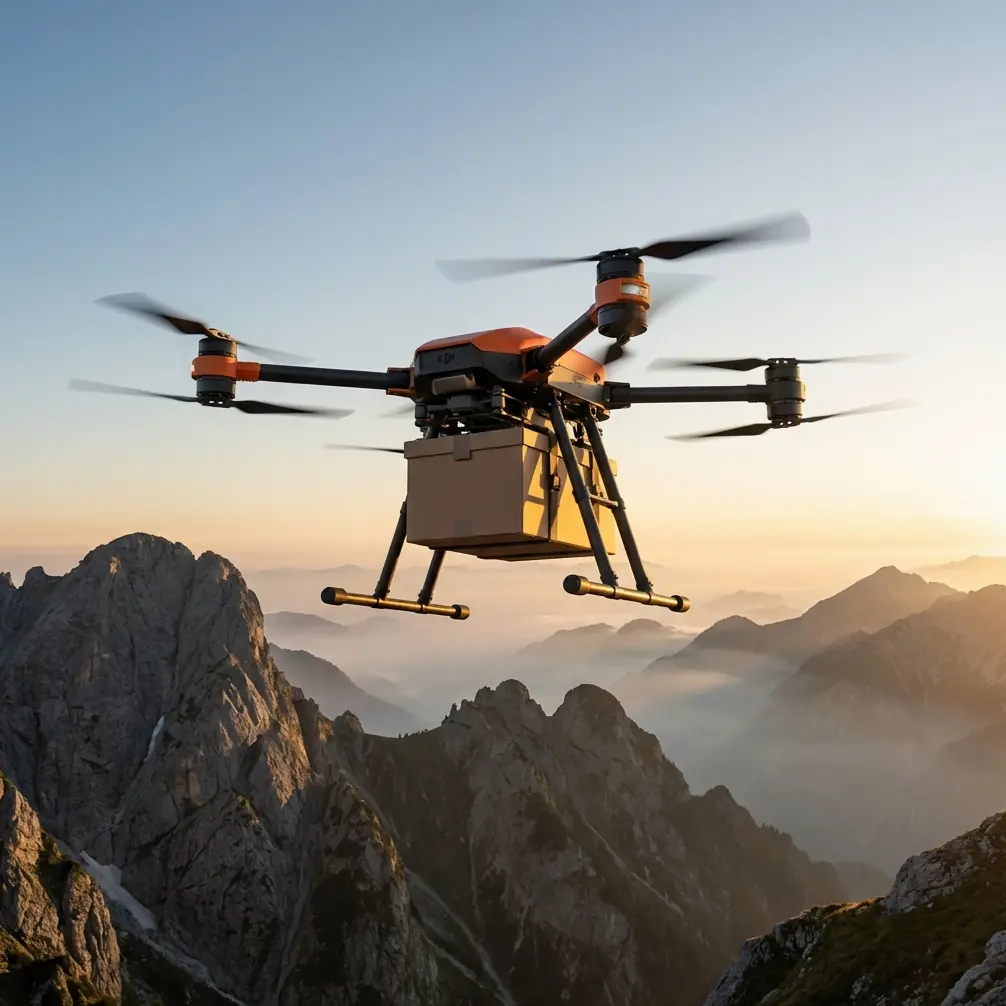
- The FlyCart 30 supports payloads up to 30 kg, making it ideal for deploying wildlife monitoring equipment in terrain that's impossible to reach on foot.
- Dual-battery architecture delivers up to 28 minutes of flight time under heavy loads, giving teams enough endurance for deep-wilderness survey missions.
- Built-in winch system enables precise equipment drops without landing, protecting sensitive habitats from rotor wash and ground disturbance.
- BVLOS-capable flight planning and an emergency parachute system keep operations safe and compliant across vast, unpopulated survey zones.
Why Traditional Wildlife Inspection Methods Are Failing
Remote wildlife inspection has a logistics problem. Research teams spend days hiking into rugged terrain carrying camera traps, acoustic sensors, and tracking devices—only to retrieve them weeks later with the same grueling effort. Helicopters are expensive, disruptive to animal behavior, and impractical for frequent rotations.
The DJI FlyCart 30 changes this equation entirely. This heavy-lift delivery drone was engineered for cargo transport, but its capabilities map perfectly onto the demands of remote ecological fieldwork. Below, you'll learn exactly how to configure, plan, and execute wildlife inspection missions using the FlyCart 30—including a real-world solution for electromagnetic interference that nearly grounded one of our survey operations.
Step 1: Understand the FlyCart 30's Core Specifications
Before planning any mission, you need to know what this platform can actually do. The FlyCart 30 isn't a modified camera drone. It's a purpose-built logistics aircraft with specs that matter for field science.
| Specification | FlyCart 30 Detail | Relevance to Wildlife Ops |
|---|---|---|
| Max Payload | 30 kg (cargo mode) | Deploy multiple sensor packages per flight |
| Payload Ratio | Approx. 1:1 (payload to airframe weight) | Best-in-class for heavy-lift drones |
| Max Flight Time | 28 min (loaded) / 40 min (unloaded) | Sufficient for 10+ km round-trip sorties |
| Winch System | 20 m cable, 40 kg rated capacity | Drop equipment without landing |
| Battery System | Dual-battery hot-swappable | Continuous ops with minimal downtime |
| Wind Resistance | Up to 12 m/s | Operable in exposed mountain and coastal zones |
| Safety System | Integrated emergency parachute | Required for BVLOS regulatory approval |
| IP Rating | IP55 | Operates in rain and dusty conditions |
The payload ratio is the headline number here. At roughly 1:1, the FlyCart 30 carries its own weight in cargo—a benchmark that very few platforms in this class achieve. For wildlife teams, that means deploying a full sensor suite (camera traps, GPS collars for airdrop, acoustic monitors, and weatherproof housings) in a single sortie.
Expert Insight: When calculating your payload, don't forget the weight of the winch cable itself. At full 20 m extension, the cable and hook assembly consume approximately 1.2 kg of your total payload budget. Factor this into every load plan.
Step 2: Plan Your Route for BVLOS Operations
Wildlife inspection zones are, by definition, remote. You'll almost certainly be operating beyond visual line of sight (BVLOS), which introduces both regulatory requirements and practical flight-planning challenges.
Regulatory Prerequisites
Before you fly BVLOS, ensure you have:
- Airspace authorization from the relevant civil aviation authority
- A filed flight plan with waypoints, altitudes, and contingency landing zones
- An active observer network or DAA (Detect and Avoid) system as required by local regulations
- Emergency parachute system armed and tested—the FlyCart 30's integrated chute satisfies most regulatory frameworks as a mandatory termination system
Route Optimization Strategy
The FlyCart 30's DJI DeliveryHub software allows you to pre-program multi-waypoint routes with precision altitude holds. Here's how to optimize for wildlife missions:
- Map your sensor deployment sites using satellite imagery and GPS coordinates gathered from prior ground surveys.
- Set cruise altitude at 100–120 m AGL to minimize acoustic disturbance to wildlife while maintaining safe terrain clearance.
- Program hover-and-winch waypoints at each deployment site. The aircraft will hold position while the winch lowers equipment.
- Build in a 15% energy reserve beyond what the route optimization software calculates. Wind patterns in mountain valleys and coastal corridors are unpredictable.
- Designate at least two emergency landing zones along every route segment. The system's emergency parachute will deploy automatically if a critical failure is detected, but a flat clearing reduces equipment damage risk.
The dual-battery system is your safety net here. Each battery pack operates independently, so a single cell failure doesn't result in total power loss. The aircraft will alert you and automatically reroute to the nearest safe landing point.
Step 3: Configure the Winch System for Habitat-Safe Deployments
This is where the FlyCart 30 earns its place in wildlife fieldwork. Landing a 30 kg+ aircraft in a sensitive habitat—a nesting colony, a wetland margin, a dense forest floor—causes unacceptable disturbance. The winch system eliminates that problem.
Winch Deployment Protocol
- Attach your sensor package to the winch hook using a standardized quick-release carabiner rated for at least 1.5x the package weight.
- Secure all cables and antennas flush to the package body to prevent snagging during descent through canopy gaps.
- Program the winch descent speed to a slow, controlled rate—approximately 0.5 m/s is ideal for forested areas where branches may deflect the load.
- Use the FPV camera feed to monitor the package as it descends. The FlyCart 30's downward-facing camera gives you real-time visual confirmation of placement.
- Trigger the quick-release once the package is grounded and the cable goes slack.
Pro Tip: For retrieval missions, attach a lightweight radio beacon to each sensor package during initial deployment. This allows the FlyCart 30's onboard systems to home in on the exact pickup coordinate, even if the package has shifted due to animal activity, water flow, or ground settling. A 10 g beacon is negligible in your payload budget and saves enormous time on recovery flights.
Step 4: Handle Electromagnetic Interference in the Field
Here's a scenario that doesn't appear in any product brochure but will absolutely affect your operations.
During a raptor nesting survey along a mountain ridgeline, our team experienced severe control signal degradation at a specific waypoint. The FlyCart 30's telemetry showed intermittent link drops, and the aircraft automatically entered hover-and-hold mode—exactly as designed, but blocking mission progress.
Diagnosing the Problem
The ridgeline ran parallel to a set of high-voltage transmission lines approximately 400 m to the east. The electromagnetic interference (EMI) was strongest when the aircraft's antennas were oriented broadside to the power lines during its north-south transit heading.
The Antenna Adjustment Solution
The FlyCart 30 uses omnidirectional antennas on the aircraft and directional antennas on the DJI RC Plus controller. Here's what we did:
- Repositioned the ground control station to the west side of the ridgeline, increasing the angular separation between the controller's antenna pattern and the EMI source.
- Rotated the controller's antennas so the signal null (the weakest reception axis) pointed toward the transmission lines, while the primary lobe faced the aircraft's flight path.
- Reduced the cruise altitude by 30 m at the affected waypoint, using terrain as a natural EMI shield.
- Added an intermediate waypoint to change the aircraft's transit heading from north-south to northwest-southeast, altering the antenna orientation relative to the interference source.
After these adjustments, signal strength returned to above 85% across the entire route, and the mission completed without a single link warning.
This experience underscores a critical point: route optimization isn't just about distance and energy. It's about the electromagnetic environment. Always survey for EMI sources—power lines, radio towers, mining equipment—before finalizing waypoints.
Common Mistakes to Avoid
Even experienced drone operators make errors when transitioning to heavy-lift cargo missions in remote environments. Here are the ones that cost the most time and risk:
- Overloading the winch without accounting for dynamic forces. A 5 kg package can exert 15+ kg of force on the cable during wind gusts or sudden hover corrections. Always rate your rigging for 3x static weight.
- Neglecting pre-flight battery balancing. The dual-battery system requires both packs to be within 5% state of charge of each other at takeoff. Mismatched packs reduce flight time and can trigger premature landing warnings.
- Skipping the emergency parachute inspection. The chute is a single-use deployment system. After any activation—or after 200 flight hours without activation—the parachute cartridge must be inspected and potentially replaced.
- Flying BVLOS without a contingency communication plan. If you lose telemetry link, the aircraft will execute its return-to-home protocol. But your ground team needs a separate communication channel (satellite phone, HF radio) to coordinate with airspace authorities.
- Ignoring wildlife behavioral triggers. A 12 m/s approach at 50 m altitude will flush most bird species. Slow the approach speed to 3–5 m/s and maintain 100+ m altitude until directly over the deployment waypoint. Then descend vertically.
Frequently Asked Questions
Can the FlyCart 30 operate in heavy rain during wildlife surveys?
Yes. The FlyCart 30 carries an IP55 rating, which means it's protected against water jets from all directions. It can operate reliably in moderate to heavy rain. However, the winch system's quick-release mechanism should be tested in wet conditions before deployment, as moisture can affect carabiner friction and release timing. Always dry and inspect equipment post-flight.
How does the dual-battery system work during a mission abort?
If one battery pack fails or drops below a critical threshold, the FlyCart 30 seamlessly transitions to the remaining pack and immediately initiates a return-to-home or nearest-safe-landing sequence. The dual-battery architecture is designed for redundancy, not extended range—meaning you should never plan a mission that requires both packs to reach minimum safe endurance. Always maintain that 15% energy reserve as standard practice.
What approvals do I need for BVLOS wildlife inspection flights?
Requirements vary by jurisdiction, but most civil aviation authorities require a specific operations risk assessment (SORA), a BVLOS waiver or permit, proof of detect-and-avoid capability (or observer network), and an active emergency termination system—which the FlyCart 30's emergency parachute satisfies. Consult your national authority early in the planning process, as approval timelines can range from weeks to months.
The FlyCart 30 isn't just a delivery drone repurposed for fieldwork—it's a platform whose core engineering, from its payload ratio to its winch system to its emergency parachute, solves problems that wildlife researchers have been working around for years. The technology is here. The question is how quickly your team adopts it.
Ready for your own FlyCart 30? Contact our team for expert consultation.