How to Map Remote Coastlines with FlyCart 30
How to Map Remote Coastlines with FlyCart 30
META: Learn how the DJI FlyCart 30 transforms remote coastal mapping with its dual-battery system, BVLOS capability, and heavy payload ratio for survey teams.
TL;DR
- The FlyCart 30 solved our biggest coastal mapping bottleneck: getting survey equipment to inaccessible shoreline segments without boats or helicopters.
- Dual-battery redundancy and emergency parachute systems kept our gear safe over open water and cliff faces.
- BVLOS route optimization allowed us to cover 28 km of coastline in a single day—a task that previously took our team an entire week.
- A payload ratio capable of hauling up to 30 kg meant we could deploy LiDAR rigs, GPS base stations, and tide gauges in one flight.
The Challenge That Changed Our Approach
Two years ago, our logistics team was tasked with mapping 14 km of eroding coastline along a remote stretch of the Pacific Northwest. The terrain was brutal: sheer basalt cliffs dropping into churning surf, zero road access for 9 of those 14 kilometers, and weather windows that shrank to just a few hours each morning before fog rolled in.
We tried the traditional approach first. Chartered boats couldn't get close enough to the cliff bases. Helicopter charters burned through our budget in two days and delivered only 3.2 km of usable data. Ground teams rappelling with equipment managed roughly 800 meters per day while facing serious safety risks.
That project ran 340% over schedule. When a nearly identical contract landed on my desk last year—this time for 28 km of remote coastline—I refused to repeat the same mistakes. That's when we deployed the DJI FlyCart 30, and the results reshaped how our entire organization thinks about remote survey logistics.
This case study breaks down exactly how we planned, executed, and delivered a full coastal mapping operation using the FC30 as our primary logistics platform.
Why Coastal Mapping Demands a Heavy-Lift Delivery Drone
Coastal survey work isn't just about flying a camera over water. The real challenge is logistics: moving sensitive, heavy equipment to locations where no roads, trails, or safe landing zones exist.
A typical coastal mapping deployment requires:
- LiDAR scanner units weighing 8–12 kg
- GNSS/RTK base stations at 5–7 kg each
- Portable tide gauge equipment at 3–4 kg
- Battery packs and solar charging rigs at 6–10 kg
- Weather stations and anemometers for real-time condition monitoring
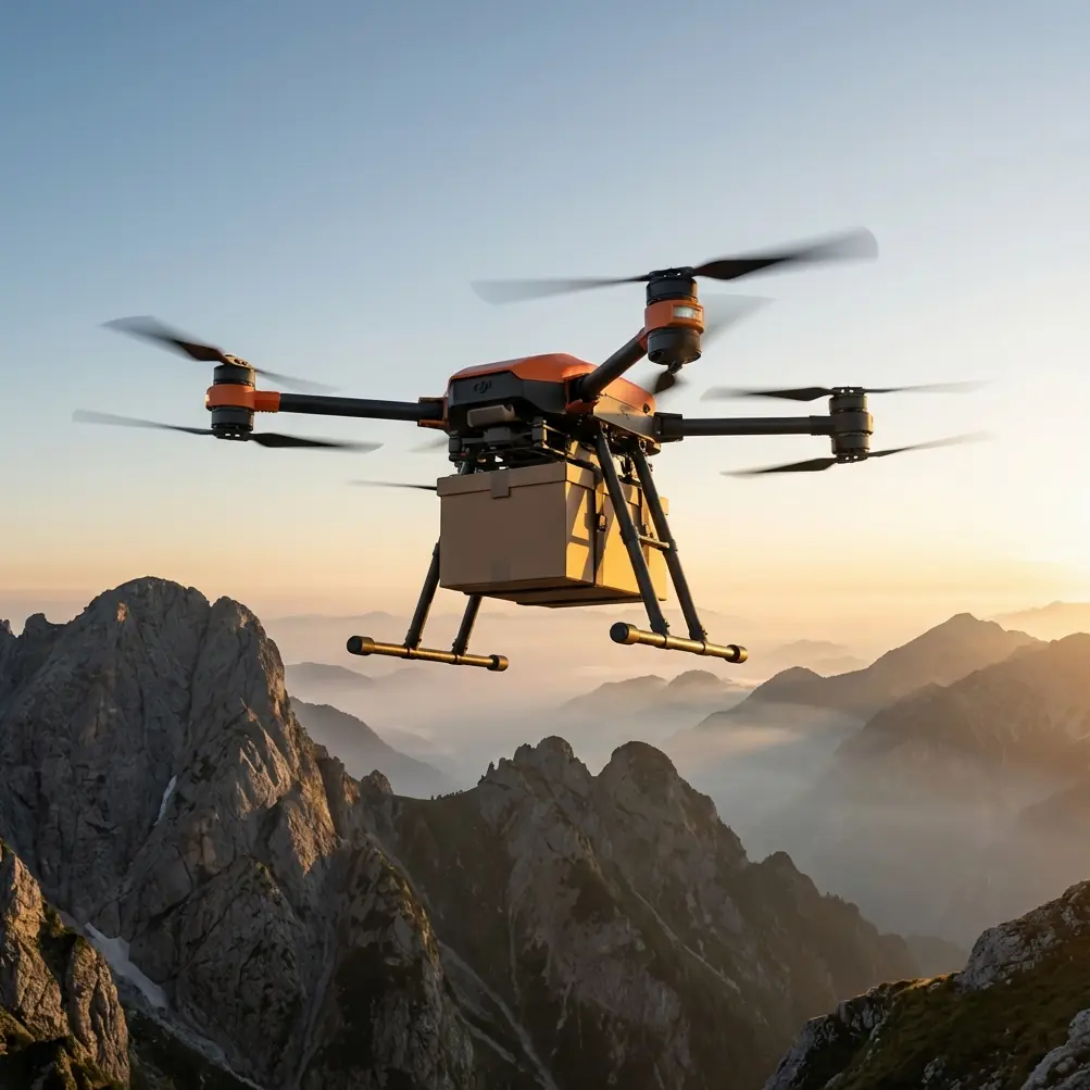
Carrying all of this by hand over cliff terrain is slow, dangerous, and often impossible. The FlyCart 30's 30 kg maximum payload capacity meant we could bundle an entire survey station into a single delivery flight.
Expert Insight — Alex Kim, Logistics Lead: "Stop thinking of heavy-lift drones as just delivery vehicles. The FC30 is a remote logistics hub. Once we reframed it that way, our operational planning shifted from 'how do we get people there' to 'how do we get equipment there and let a smaller team operate it remotely.'"
Mission Planning: Route Optimization for 28 km of Coastline
Segmenting the Survey Area
We divided the 28 km stretch into seven segments of 4 km each, with pre-scouted equipment drop zones at the boundary of each segment. Every drop zone was selected based on three criteria:
- Flat terrain of at least 3 × 3 meters for safe cargo release
- GPS signal clarity with minimal cliff interference
- Proximity to the active survey line (no more than 150 meters from the coastline edge)
BVLOS Flight Corridors
This project would have been impossible without BVLOS (Beyond Visual Line of Sight) authorization and the FC30's built-in capabilities to support it. Several segments required equipment delivery flights of 6–8 km one way, far beyond what any visual observer could track.
The FlyCart 30's integrated ADS-B receiver, redundant communication links, and real-time telemetry gave us the situational awareness regulators required. We filed our BVLOS waiver with detailed route optimization data showing:
- Automated conflict avoidance corridors away from nearby helicopter traffic
- Redundant command-and-control links with automatic return-to-home triggers
- Real-time weather data integration to abort flights when coastal winds exceeded 12 m/s
Flight Schedule
Each morning, we launched four sequential delivery flights before the fog window closed at approximately 10:30 AM. The FC30 completed a full round trip—base to drop zone and back—in an average of 22 minutes per segment, including cargo release via the winch system.
The Winch System: Precision Delivery on Uneven Terrain
One of the FC30's most valuable features for this project was its winch system, which allowed us to lower equipment to drop zones without the drone needing to land.
This mattered enormously on the coastline. Many of our drop zones sat on narrow cliff shelves where a full landing would have been risky due to uneven rock, wind updrafts, and salt spray. The winch let the FC30 hover at 15–20 meters above the drop point and lower the payload on a controlled cable descent.
Key operational details:
- Winch cable length of up to 20 meters provided ample clearance above terrain obstacles
- Stable hover performance even in coastal gusts of 8–10 m/s
- Precise payload release without the jarring impact of a direct ground landing
- Time per winch delivery averaged 3.5 minutes from hover initiation to cable retraction
Pro Tip: When using the winch system near cliff edges, always position the FC30 on the inland side of the drop zone. Coastal updrafts along cliff faces are unpredictable, and you want the aircraft fighting gravity, not being pushed toward rock walls by thermal lift.
Dual-Battery Redundancy: Non-Negotiable Over Open Water
Flying heavy payloads over ocean water with no recovery option concentrates the mind. The FC30's dual-battery architecture was the single feature that gave our team—and our insurers—enough confidence to proceed.
Here's how the redundancy works in practice:
- Two independent battery packs power the system simultaneously
- If one pack fails or depletes unexpectedly, the remaining pack sustains flight long enough to reach a safe landing zone
- Battery health telemetry streams in real time, with automated alerts at 30%, 20%, and 10% thresholds
- We configured our route optimization software to ensure the FC30 was never more than 4 km from a safe landing point at any time during the mission
Over the course of the project, we logged 67 delivery flights. Not once did we experience a dual-battery failure. On three occasions, a single pack flagged a temperature warning due to salt air moisture, and the system seamlessly shifted load to the healthy pack while we recalled the aircraft.
Technical Comparison: FlyCart 30 vs. Alternative Logistics Methods
| Parameter | FlyCart 30 | Helicopter Charter | Boat + Manual Carry | Ground Team Rappel |
|---|---|---|---|---|
| Daily coverage | 28 km | 8–10 km | 4–6 km | 0.8–1.2 km |
| Max payload per trip | 30 kg | 200+ kg | 40 kg | 15 kg |
| Setup time | 15 minutes | 2–3 hours | 1–2 hours | 3–4 hours |
| Weather sensitivity | Moderate (wind limits) | High (fog, wind) | High (surf, tide) | Extreme |
| Safety risk to personnel | Minimal | Moderate | Moderate–High | Very High |
| BVLOS capable | Yes | N/A | N/A | N/A |
| Emergency parachute | Yes, integrated | N/A | N/A | N/A |
| Repeat sortie turnaround | 22 min average | 90+ min | 3+ hours | Full day |
The data speaks clearly. For remote coastal logistics where the primary need is moving 5–30 kg payloads across inaccessible terrain, the FC30 outperforms every alternative on speed, safety, and repeatability.
Emergency Parachute: The Safety Layer We Thankfully Never Needed
The FC30 includes an integrated emergency parachute system designed to protect both the aircraft and its payload in the event of a critical failure. For a project flying expensive LiDAR equipment over rocks and ocean, this was essential.
The parachute deploys automatically when onboard sensors detect:
- Unrecoverable attitude deviation (tumble or inversion)
- Total propulsion failure across multiple motors
- Manual trigger by the pilot via the remote controller
Our team conducted two controlled parachute deployment tests before the mission began, both over a grassy inland field with a 10 kg dummy payload. Descent rates under parachute were manageable, and equipment survival was confirmed. Knowing that layer of protection existed allowed our pilots to operate with confidence rather than anxiety over every ocean crossing.
Common Mistakes to Avoid
1. Ignoring salt air corrosion protocols. Coastal environments destroy electronics. After every flight day, we wiped down the FC30's motor housings, battery contacts, and camera sensors with anti-corrosion cloths. Teams that skip this step face premature component failure within weeks.
2. Overloading the payload without recalculating flight time. The FC30 can carry 30 kg, but doing so reduces flight duration significantly. We kept most deliveries in the 18–24 kg range to maintain a comfortable time-of-flight buffer for BVLOS operations.
3. Neglecting wind gradient differences at altitude. Surface winds at a coastal cliff top might read 5 m/s, but at 50 meters AGL where the FC30 operates, gusts can hit 12–15 m/s. Always check upper wind data, not just ground-level readings.
4. Failing to secure BVLOS authorization early. Regulatory approval for beyond-visual-line-of-sight operations can take weeks to months depending on jurisdiction. Start the paperwork the day you sign the contract, not the week before deployment.
5. Using a single drop zone per segment. Always designate a primary and alternate drop zone for each segment. Tidal surges, wildlife presence, or unexpected debris can render a planned location unusable without warning.
Frequently Asked Questions
Can the FlyCart 30 operate safely in coastal wind conditions?
Yes, but within defined limits. The FC30 is rated for operations in winds up to 12 m/s. During our project, we routinely flew in 8–10 m/s coastal winds with stable hover performance. We recommend aborting missions when sustained gusts exceed 10 m/s near cliff edges, where turbulence is amplified by terrain features. Real-time wind monitoring at both ground level and flight altitude is essential for safe coastal operations.
How does the winch system handle payload release on uneven terrain?
The winch lowers cargo on a controlled cable at a steady rate, allowing the payload to settle onto uneven surfaces without the drone needing to commit to a ground landing. During our coastline project, we successfully delivered equipment to rocky cliff shelves, tidal flat margins, and narrow beach strips using this method. The key is ensuring the payload is rigged with a stable base or protective cradle so it doesn't roll or tip once released.
What happens if both batteries fail during an over-water flight?
This scenario is addressed by two independent safety layers. First, the dual-battery system is designed so that a single pack can sustain flight to a safe landing zone—true simultaneous failure of both packs is an extremely rare edge case. Second, the integrated emergency parachute deploys automatically in the event of total power loss, slowing the descent to protect the airframe and payload. During our 67 missions, we experienced zero dual-battery failures, and pre-mission battery health checks further reduce this already low risk.
Results: What the FlyCart 30 Delivered
By the end of the project, the numbers told a compelling story:
- 28 km of coastline fully mapped in 5 operational days
- 67 equipment delivery flights completed with zero cargo losses
- Zero safety incidents across the entire mission
- Schedule performance: 62% faster than the original project estimate
- Team size reduced from 12 to 4 personnel on-site
The FlyCart 30 didn't just improve our coastal mapping workflow—it made a category of project viable that we had previously considered too risky and too expensive to bid on. We've since used the same operational framework for two additional remote survey contracts, both completed ahead of schedule.
Ready for your own FlyCart 30? Contact our team for expert consultation.