FlyCart 30 Mapping Tips for Mountain Coastlines
FlyCart 30 Mapping Tips for Mountain Coastlines: What This Week’s Low-Altitude Safety Debate Means in the Field
META: Expert FlyCart 30 tutorial for mountain coastline mapping, covering safety tradeoffs, route planning, winch operations, dual-battery strategy, and why practical risk control matters more than chasing absolute safety.
Mountain coastline work exposes every weak point in an aerial logistics platform. Wind folds over cliffs. Salt air shortens margins. Landing zones are scarce, and the people approving missions often carry a simple instinct: if there is any uncertainty, stop the operation.
That instinct is understandable. It is also where many promising low-altitude operations stall.
A recent comment from Chinese industry figure Shan Xiaoming, speaking on March 7, cuts directly into this issue. His point was not that safety should be relaxed. It was that the low-altitude sector should not ignore safety for the sake of growth, but it also should not choke off deployment by chasing absolute safety. That distinction matters for anyone evaluating the FlyCart 30 for mountain coastline mapping support, especially when the aircraft is being asked to do more than fly a straight line from point A to point B.
At nearly the same time, a separate public safety discussion in the US highlighted another operational truth: agencies such as FDNY are looking at how drones, ground robots, and other robotic systems can work together to improve situational awareness during emergency response. That idea of robotic convergence sounds like a public safety headline, but it has direct relevance to coastline survey logistics. Mapping teams in steep, remote shoreline environments already need exactly that kind of coordinated workflow: air assets for line-of-sight extension, ground teams for target confirmation, and structured decision-making for dynamic hazards.
Put those two developments together and a clear lesson emerges. The FlyCart 30 is not most valuable when treated as a miracle machine. It is most valuable when used inside a disciplined operating system that accepts risk, measures it, and controls it without freezing the mission.
Why this matters specifically for FlyCart 30 users
The FlyCart 30 sits in a category that invites overconfidence and overrestriction at the same time. Heavy-lift drone operators know the pattern. One group focuses on payload and range and assumes the aircraft can muscle through terrain. Another group becomes so concerned with edge-case hazards that every mission becomes impossible to approve.
Neither approach survives contact with a mountain coastline.
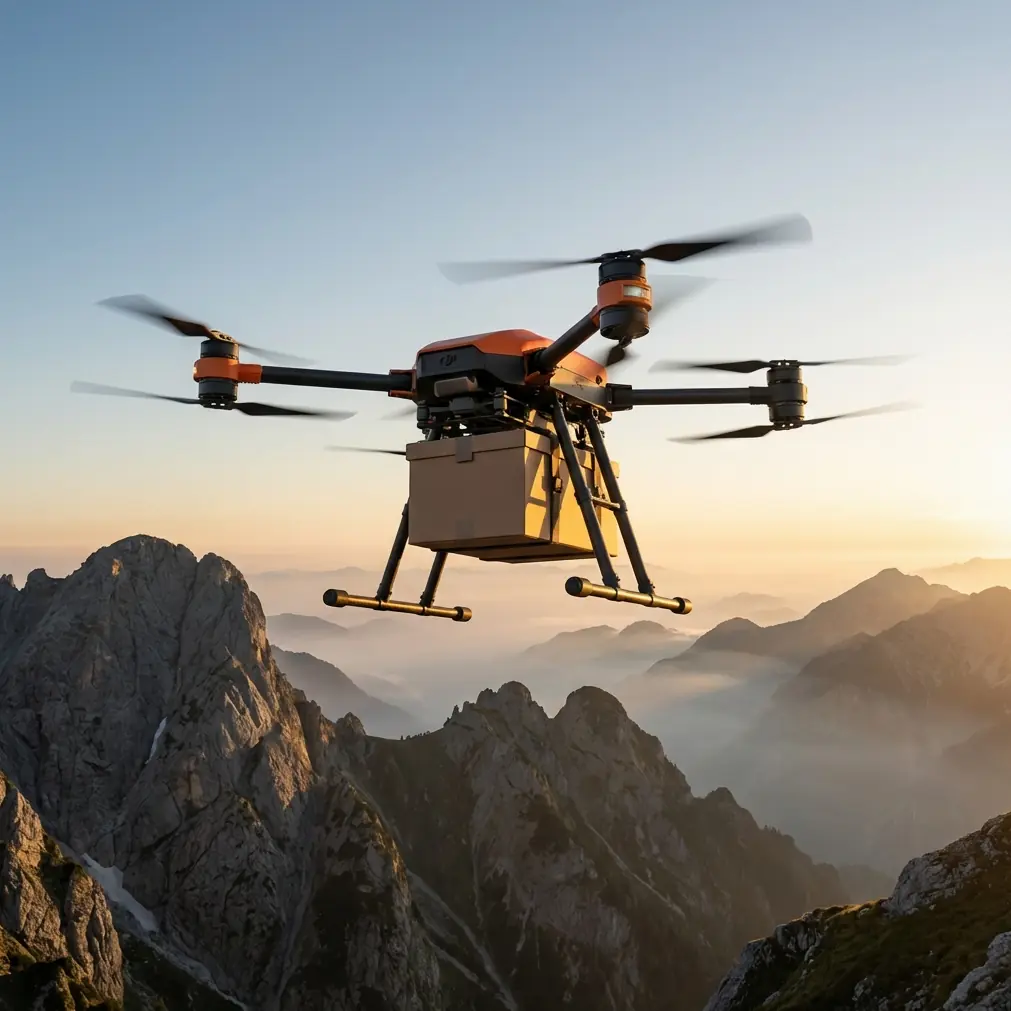
For these jobs, the aircraft’s payload ratio matters because every extra kilogram must justify itself against wind exposure, battery consumption, and escape options. The FlyCart 30 tends to stand out against lighter-duty competitors because it is built for real transport work rather than cosmetic lifting specs. In practical terms, that means the platform can support mapping-adjacent logistics that many survey drones cannot: battery resupply to ridge teams, sensor kit drops, rope line delivery, first-aid payload movement, and support gear insertion without forcing a full landing in unstable terrain.
That last point is where the winch system changes the mission design.
In a mountain coastline environment, landing is often the riskiest phase, not cruise. Loose rock, uneven ground, rotor wash near cliff edges, and uncertain surface conditions all argue against touching down unless absolutely necessary. A well-executed winch delivery lets the FlyCart 30 hold a safer hover while transferring equipment vertically to a team below. Compared with competitors that rely more heavily on landing-based delivery or less refined drop procedures, this is not just convenient. It directly reduces ground interaction risk.
And that returns us to Shan Xiaoming’s warning about “absolute safety.” If a mission approval team interprets safety as “never hover near a slope, never lower a load, never operate unless every variable is fixed,” they do not create a safer coastline workflow. They create paralysis. The real standard should be whether the risk is identified, bounded, and managed through equipment choice, route design, weather thresholds, crew roles, and emergency procedures.
A practical FlyCart 30 tutorial for mountain coastline mapping support
If your core task is coastline mapping in mountainous terrain, the FlyCart 30 should not replace your mapping aircraft. It should support the mapping system around it. That distinction is where many teams get better results.
Here is how I would structure operations.
1. Treat the FC30 as the logistics spine, not the primary sensor ship
Dedicated mapping aircraft are optimized for image geometry, sensor stability, and repeatable track lines. The FlyCart 30 is better used to keep those aircraft and field teams productive when the terrain makes ground access inefficient or unsafe.
Examples include:
- delivering spare batteries to a survey crew positioned above a rocky shoreline
- moving GNSS gear to a ridge marker team
- lowering comms relays or compact weather sensors into difficult access points
- transferring emergency supplies when a shoreline path becomes unusable
This is where payload ratio becomes operationally decisive. A platform with limited lifting margin often forces you to split missions into multiple flights. In mountains, that compounds exposure. Fewer sorties with a properly loaded aircraft can be safer than many lightly loaded flights, provided the route and performance envelope are respected.
2. Build routes for terrain, not map lines
On paper, the shortest route often looks efficient. On a mountain coast, it can be the most punishing.
Route optimization for the FlyCart 30 should account for:
- ridge-induced turbulence
- sea breeze transitions near cliff bands
- fallback hover zones
- emergency release geometry if a suspended load destabilizes
- communication dead spots behind terrain features
This is where BVLOS planning becomes more than a regulatory discussion. Even when rules or mission design still require visual oversight, the operational logic of BVLOS discipline is useful: pre-validated corridors, alternate paths, communication checks, contingency landing logic, and handoff procedures between crew positions.
Teams that borrow this mindset from more mature long-range operations tend to outperform improvised field crews. They fly less emotionally. They make fewer last-minute decisions. They recover faster when conditions shift.
3. Use the winch system to remove the landing problem
If there is one feature that deserves more attention in mountain coastline work, it is the winch system. Competitor platforms may advertise lifting ability, but the field question is simpler: can the aircraft complete the transfer without forcing a dangerous touchdown?
For coastline mapping support, a winch-based workflow helps in three common scenarios:
- cliff-top teams needing batteries or radios without stepping into unstable landing areas
- shoreline crews receiving gear where surf, rocks, or slope prevent safe landing
- temporary relay placement where payloads need precise vertical positioning
The trick is procedural discipline. Do not improvise load lowering over people who are not briefed. Establish sterile zones. Assign one ground receiver. Standardize hand signals or radio calls. Define abort criteria before the aircraft leaves base.
That is the difference between practical safety and symbolic safety. Symbolic safety says “do not do difficult things.” Practical safety says “do difficult things in a controlled, repeatable way.”
4. Make dual-battery management part of mission planning, not a spec-sheet footnote
In cold spray, crosswinds, and vertical terrain, battery behavior becomes mission logic. The FlyCart 30’s dual-battery architecture matters because redundancy and endurance are not abstract benefits in these conditions. They influence whether your team can keep a reserve for rerouting, hover stabilization, or a conservative return profile.
A common mistake is planning battery use around ideal cruise. Mountain coastline missions almost never stay in ideal cruise. They hover while crews reposition. They divert around gust fronts. They hold during load confirmation. They climb more aggressively than expected when terrain masks the preferred line.
Build your power budget around the ugliest normal case, not the prettiest expected one.
I recommend defining three internal thresholds:
- mission continuation threshold
- delivery-only threshold
- immediate return threshold
That framework prevents crews from rationalizing marginal decisions in the air. It also supports the bigger theme raised by the March 7 policy comment: real industry progress depends on practical control systems, not fantasy standards. Safety improves when crews know when to continue, when to simplify, and when to quit.
5. Do not ignore the emergency parachute, but do not build your whole safety story around it either
The emergency parachute belongs in the risk stack, but it should never be the main argument for approving a difficult mission. On a cliff-lined coast, the better protection is still route discipline, weather minimums, load security, and airspace awareness.
That said, the parachute has clear operational significance. In places where loss of controlled flight could otherwise send the aircraft or suspended payload into inaccessible terrain, surf zones, or public areas near scenic viewpoints, an emergency recovery layer can reduce the severity of a worst-case event.
The key is to brief it honestly. It is a damage-mitigation tool, not permission to take lazy risks.
What FDNY’s robotics discussion adds to FlyCart 30 planning
The FDNY conversation about combining drones, ground robots, and other robotic systems to improve situational awareness is easy to pigeonhole as public safety theory. That would be a mistake.
Mountain coastline mapping support increasingly looks like a multi-robot problem.
The mapping aircraft collects imagery. The FlyCart 30 moves payloads. Ground teams verify markers and retrieve gear. In some environments, rover-type platforms or stationary sensors contribute local data the aircraft cannot safely gather in persistent wind channels.
This convergence model matters because it reframes the FlyCart 30. It is not just a flying carrier. It is a node in a broader system. Once you think that way, operations improve.
For example:
- a ground team can scout a safer winch drop zone before the FC30 launches
- a smaller reconnaissance drone can check cliff-edge wind behavior before a heavier payload flight
- field teams can relay updated route constraints after rockfall, surf changes, or trail closure
- logistics flights can be timed around sensor collection windows rather than interrupting mapping lines
This is how professional programs scale. Not by asking one aircraft to do everything, but by letting each system do the job it is best suited for.
Where FlyCart 30 can outperform competitors in this niche
For mountain coastline logistics support, the advantage is rarely a single headline number. It is the combination of heavy-lift utility, winch-enabled transfer, and enough operational maturity to fit into structured workflows.
Many competitor aircraft can carry something. Fewer can do it in a way that reduces touchdown exposure in ugly terrain. Fewer still fit neatly into a mission architecture that includes route optimization, battery reserve discipline, emergency procedures, and possible BVLOS-style corridor planning.
That is why the FlyCart 30 is especially strong here. It gives teams a way to convert inaccessible terrain from a stop sign into a manageable variable.
If you are building or refining such a workflow and want to compare mission profiles with an experienced operator, this direct operations chat is a practical place to start the conversation.
The real takeaway from this week’s news
The March 7 policy remark and the FDNY robotics discussion point in the same direction, even though they come from very different contexts.
First, low-altitude operations should not be smothered by the pursuit of absolute safety. Second, risk becomes more manageable when drones are integrated into a broader operational system instead of being treated as isolated gadgets.
For FlyCart 30 users working around mountain coastlines, that means the right question is not “Is this aircraft perfectly safe?” No serious operator should ask that. The right question is “Can this aircraft complete this support task inside a disciplined system that reduces exposure, preserves margins, and keeps people out of worse situations?”
That is a much better question. It is also the one that leads to fieldable missions.
When you answer it properly, the FlyCart 30 stops being a brochure platform and becomes what it should be: a practical logistics aircraft for difficult terrain, one that earns its place not through hype but through controlled, repeatable performance.
Ready for your own FlyCart 30? Contact our team for expert consultation.