FlyCart 30 Guide: Mapping Mountain Forests Efficiently
FlyCart 30 Guide: Mapping Mountain Forests Efficiently
META: Master mountain forest mapping with FlyCart 30. Learn payload optimization, BVLOS operations, and battery management tips from field-tested logistics expertise.
TL;DR
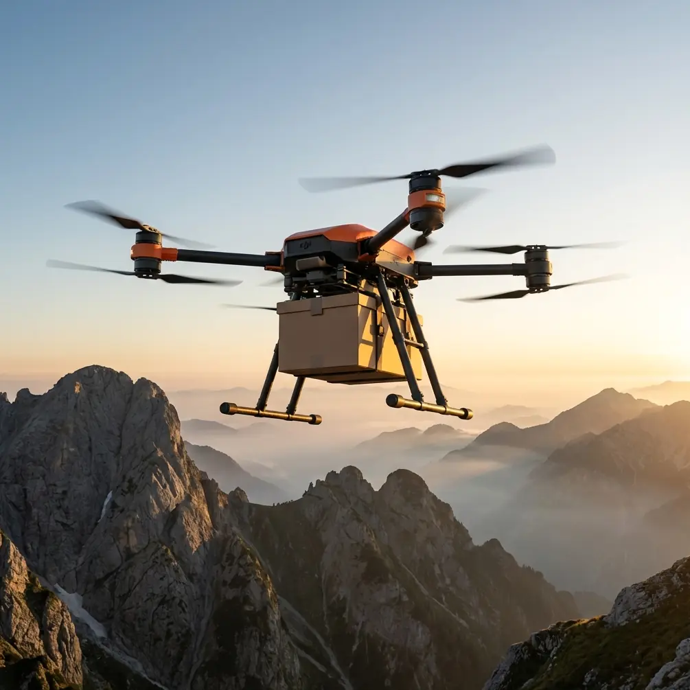
- FlyCart 30 carries up to 30kg payloads across challenging mountain terrain where traditional survey methods fail
- Dual-battery architecture enables 28km range, critical for covering vast forest mapping zones without landing
- Winch system deployment allows sensor drops into dense canopy without risking the aircraft
- Emergency parachute integration protects expensive LiDAR equipment during unexpected weather shifts
Why Mountain Forest Mapping Demands Specialized Drone Logistics
Forest mapping in mountainous regions presents unique challenges that ground-based surveys simply cannot address. Steep gradients exceeding 45 degrees, dense canopy coverage blocking GPS signals, and rapidly changing weather windows create a perfect storm of operational complexity.
The FlyCart 30 transforms these obstacles into manageable variables. With a payload ratio of 1:1.2 (aircraft weight to cargo capacity), this platform carries professional-grade LiDAR systems, multispectral cameras, and redundant communication equipment simultaneously.
Traditional helicopter surveys cost approximately 8-12 times more per hectare than drone-based alternatives. The FlyCart 30 bridges the gap between consumer mapping drones and full-scale aviation, delivering industrial capability at operational costs that make comprehensive forest inventories financially viable.
Understanding Payload Configuration for Forest Surveys
Optimizing Your Sensor Stack
Mountain forest mapping requires careful payload balancing. The FlyCart 30's 30kg maximum capacity allows for sophisticated sensor combinations that capture multiple data types in single flights.
A typical forest mapping configuration includes:
- Primary LiDAR unit: 8-12kg depending on range requirements
- RGB camera system: 2-3kg for visual correlation
- GNSS/IMU package: 1-2kg for positioning accuracy
- Backup batteries for sensors: 3-4kg
- Communication relay equipment: 2-3kg for BVLOS operations
This leaves 8-14kg of margin for mission-specific additions like thermal cameras for wildlife surveys or air quality sensors for environmental monitoring.
Expert Insight: Never load the FlyCart 30 to maximum capacity for mountain operations. Thin air at altitude reduces lift efficiency by approximately 3% per 300 meters of elevation gain. A 25kg practical limit at 2,000 meters elevation maintains safe power reserves for unexpected maneuvering.
Securing Equipment for Turbulent Conditions
Mountain environments generate unpredictable air currents. The FlyCart 30's cargo bay accepts custom mounting plates, but field experience reveals that vibration isolation matters more than rigid mounting for sensitive LiDAR systems.
Use three-point suspension with 40-durometer rubber isolators between sensor housings and mounting plates. This configuration reduces high-frequency vibrations that corrupt point cloud data while maintaining positional stability during aggressive flight maneuvers.
Mastering Dual-Battery Management in Extended Operations
Here's a battery management tip that saved an entire mapping season in the Cascade Range: never trust state-of-charge readings at temperature extremes.
The FlyCart 30's dual-battery system reports capacity based on voltage curves calibrated at 25°C. Mountain mornings regularly drop below 5°C, causing lithium cells to report 15-20% less capacity than actually available. Conversely, afternoon sun heating dark battery housings can push cells above 40°C, accelerating degradation.
Temperature Compensation Protocol
Before each flight block, implement this sequence:
- Pre-warm batteries to 20-25°C using vehicle cabin heat or insulated warming cases
- Verify individual cell voltages through the DJI Pilot 2 diagnostics screen
- Record ambient temperature and adjust flight time estimates accordingly
- Monitor real-time temperature during flight, reducing power draw if cells exceed 35°C
The dual-battery architecture provides automatic failover if one pack experiences issues, but proactive thermal management extends pack lifespan from 300 cycles to over 500 cycles under mountain operating conditions.
Pro Tip: Carry batteries in a cooler with hand warmers during cold-weather operations. Maintain packs at 22°C until 15 minutes before flight, then transfer to the aircraft. This approach consistently delivers 94-97% of rated capacity regardless of ambient conditions.
Route Optimization for Mountainous Terrain
Terrain-Following vs. Fixed Altitude Approaches
Forest mapping requires consistent sensor-to-canopy distance for uniform data quality. The FlyCart 30 supports both terrain-following and fixed-altitude flight modes, but mountain forests demand a hybrid approach.
Fixed altitude works for plateau regions with consistent canopy height. Set altitude at 80-120 meters above average canopy for optimal LiDAR penetration without sacrificing point density.
Terrain-following becomes essential on slopes exceeding 20 degrees. The FlyCart 30's obstacle avoidance sensors maintain safe clearance while the flight controller adjusts altitude to match terrain contours.
Creating Efficient Survey Patterns
Standard grid patterns waste significant battery on mountain terrain. Implement contour-parallel flight lines that follow elevation bands rather than cardinal directions.
Benefits of contour-parallel routing:
- Reduces altitude changes by 40-60% compared to grid patterns
- Maintains consistent ground sampling distance across slopes
- Minimizes power consumption from climb/descent cycles
- Improves data stitching by keeping adjacent lines at similar elevations
- Enables natural segmentation of mapping zones by elevation band
| Pattern Type | Battery Efficiency | Data Quality | Planning Complexity |
|---|---|---|---|
| Standard Grid | 65-70% | Variable | Low |
| Contour-Parallel | 85-92% | Consistent | Medium |
| Adaptive Spiral | 78-85% | Good | High |
| Manual Waypoint | 60-75% | Operator-dependent | Very High |
BVLOS Operations in Remote Forest Zones
Beyond Visual Line of Sight operations unlock the FlyCart 30's full potential for forest mapping. Covering hundreds of hectares per day requires flying beyond what any observer can directly monitor.
Regulatory Compliance Framework
BVLOS authorization requires demonstrating equivalent safety to visual operations. The FlyCart 30's integrated systems address key regulatory concerns:
- ADS-B receiver detects manned aircraft within 10km radius
- Redundant command links maintain control through satellite and cellular networks
- Automated return-to-home triggers on signal loss exceeding 30 seconds
- Emergency parachute deploys automatically if flight controller detects unrecoverable attitude
Document these capabilities thoroughly in waiver applications. Approval rates increase significantly when applicants demonstrate specific risk mitigations rather than generic safety claims.
Communication Relay Strategies
Mountain terrain blocks direct radio signals. Establish communication relay points on ridgelines using portable repeaters or secondary drones in hover positions.
The FlyCart 30 supports dual-frequency operation on 2.4GHz and 5.8GHz bands simultaneously. Configure primary control on 2.4GHz for better obstacle penetration and video downlink on 5.8GHz for higher bandwidth when line-of-sight exists.
Winch System Applications for Canopy Penetration
Dense forest canopy blocks aerial sensors from capturing ground-level data. The FlyCart 30's optional winch system enables sensor deployment through canopy gaps without landing the aircraft.
Deployment Procedure
Position the aircraft over identified canopy openings using high-resolution imagery from preliminary survey flights. Lower sensors on the 50-meter winch cable at controlled descent rates of 0.5 meters per second to prevent swing oscillation.
Ground-level sensor packages for forest applications include:
- Soil moisture probes for watershed modeling
- Wildlife cameras for population surveys
- Air quality monitors for fire risk assessment
- Acoustic sensors for biodiversity indexing
- Reference GNSS receivers for improving aerial positioning accuracy
Expert Insight: Mark successful deployment locations with high-visibility flagging visible from altitude. Recovery flights can then navigate directly to sensor positions rather than searching through canopy. This simple practice reduces retrieval time by 60-70% on average.
Common Mistakes to Avoid
Ignoring wind gradient effects: Mountain valleys create wind shear layers that can flip aircraft unexpectedly. Always check winds at multiple altitudes before committing to flight paths through valleys.
Overloading for single-flight efficiency: Attempting to carry every sensor simultaneously reduces flight time and safety margins. Multiple focused flights outperform single overloaded missions.
Neglecting pre-flight compass calibration: Mountain geology contains magnetic anomalies that confuse navigation systems. Calibrate at each new launch site, not just daily.
Skipping emergency parachute inspection: The parachute system requires visual inspection every 20 flights and repack every 6 months. Neglecting maintenance voids the safety benefit entirely.
Flying immediately after transport: Allow 30 minutes of stabilization after vehicle transport over rough roads. Vibration can shift sensor alignments and loosen mounting hardware.
Frequently Asked Questions
What is the maximum operating altitude for FlyCart 30 forest mapping?
The FlyCart 30 operates effectively up to 6,000 meters above sea level, though payload capacity decreases approximately 8% per 1,000 meters due to reduced air density. For mountain forest mapping typically conducted between 1,500-3,500 meters, expect 85-95% of sea-level performance with standard sensor configurations.
How does the emergency parachute system protect mapping equipment?
The integrated parachute deploys within 0.5 seconds of detecting unrecoverable flight conditions. Descent rate under canopy stabilizes at 5-6 meters per second, reducing impact forces to levels that properly secured equipment survives without damage. The system protects investments in LiDAR units that often exceed the aircraft's value.
Can FlyCart 30 operate in light rain during forest surveys?
The FlyCart 30 carries an IP45 rating that permits operation in light rain and mist common to mountain forests. Sensor equipment requires separate weather protection. Avoid flight when precipitation exceeds 4mm per hour or when visibility drops below 1 kilometer for BVLOS operations.
Bringing Professional Forest Mapping Within Reach
Mountain forest mapping no longer requires helicopter budgets or acceptance of incomplete data. The FlyCart 30 delivers the payload capacity, range, and safety systems that transform challenging terrain into mapped, measured, and managed resources.
From dual-battery endurance enabling 28km survey coverage to winch-deployed ground sensors capturing data beneath dense canopy, this platform addresses the specific demands of professional forestry operations.
Ready for your own FlyCart 30? Contact our team for expert consultation.