Mapping Vineyards in the Mountains With FlyCart 30: A Field
Mapping Vineyards in the Mountains With FlyCart 30: A Field-Driven Technical Review
META: A practical technical review of the DJI FlyCart 30 for mountain vineyard operations, covering route planning, battery management, winch use, payload tradeoffs, and safety systems.
Mountain vineyards punish weak logistics. Tight access roads, terraced slopes, gusty ridgelines, and scattered work zones turn simple transport into a recurring bottleneck. When crews are moving mapping batteries, RTK gear, field sensors, sample kits, or small support loads between staging points and upper blocks, the aircraft matters less as a spectacle and more as a system. That is the right lens for evaluating the FlyCart 30.
I’m writing this from the perspective of a logistics lead, not someone chasing spec-sheet drama. In vineyard terrain, the FlyCart 30 is interesting because it sits at the intersection of cargo drone capability and operational discipline. It is not a mapping aircraft in the strict sense. It does not replace your survey platform. What it does is remove friction around mapping missions in places where elevation, slope, and access delays quietly eat half the day.
For mountain vineyard teams, that distinction is practical. The value of the FlyCart 30 comes from how reliably it can support the mission around the mission.
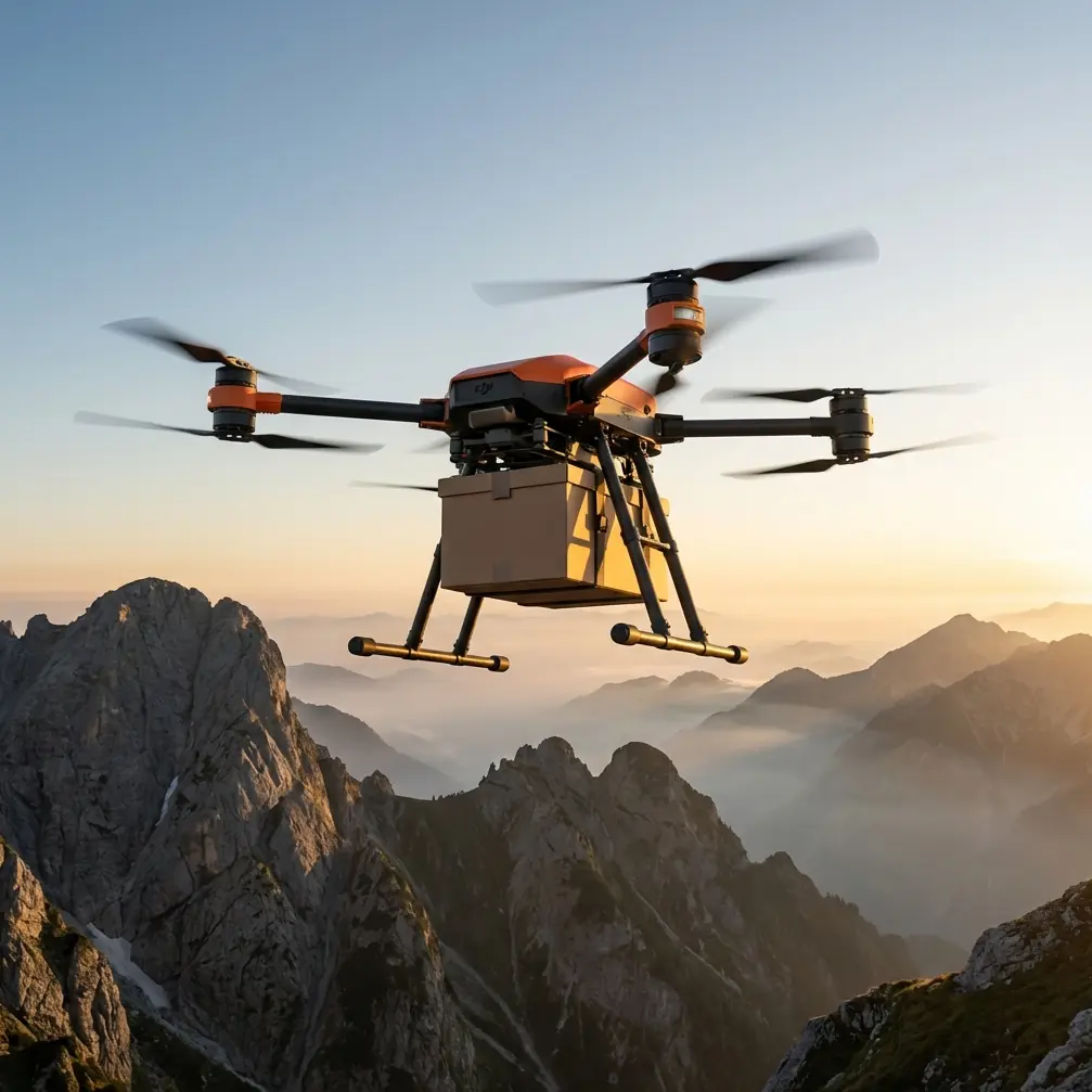
The first feature that changes the equation is the aircraft’s transport capacity relative to the kind of equipment vineyard crews actually move. The FlyCart 30 is built around meaningful lift, with a maximum payload up to 30 kg in dual-battery configuration and up to 40 kg when using a single battery setup. Those numbers are not just brochure trivia. They define how you think about payload ratio in the field.
A mapping team rarely carries one neat, uniform load. You are moving GNSS bases, spare drone batteries, charging hardware, weather instruments, markers, tools, water, and sometimes emergency supplies for crews working several terraces above vehicle access. If your payload ratio is poor, every extra kilogram pushes you into awkward decisions: split the load, add another cycle, reposition the team, or send a person uphill on foot. With the FlyCart 30, the useful conversation becomes load shape and mission profile, not whether the aircraft is even in the game.
That payload flexibility matters even more in vineyards cut into mountainsides because vertical separation changes the cost of every trip. A short line on a 2D map may still involve a punishing climb. When the aircraft can consolidate loads, route optimization becomes far more effective. You are no longer planning around what the road network allows. You are planning around direct access between functional nodes: lower staging area, ridge transfer point, upper terrace, and sensor installation site.
That is where the FlyCart 30’s winch system becomes operationally significant. In a mountain vineyard, landing zones are often the weakest link. Flat space is scarce. Vine rows are narrow. Ground cover can be wet, uneven, or full of trellis wire and irrigation lines. A drone that requires a clean touchdown every time is a drone that forces compromises. The FlyCart 30’s winch allows the aircraft to hover and lower cargo into position rather than commit to a risky landing on a marginal patch of terrain.
For vineyard mapping support, this is one of the most underappreciated advantages of the platform. You can stage gear near a terrace edge, lower a sensor package into a safe clearing, or deliver replacement batteries to a crew standing in a confined row without forcing rotor wash into vines at close range. It also shortens the handoff. The team receives the load, secures it, and the aircraft departs. Less time on station means less exposure to slope turbulence and fewer chances for small procedural errors.
That matters because mountain air is rarely stable for long. A morning that starts calm can shift quickly as sun heats the slope and valley winds begin to channel through gaps in the terrain. In those conditions, route optimization is not about software elegance. It is about preserving margin. The smartest FlyCart 30 operators I’ve worked with do not simply pick the shortest line. They build routes that avoid rotor exposure near ridgelines, reduce time spent fighting crosswinds, and preserve a safe return envelope after payload release.
This is also where BVLOS discussions become relevant, even if your operation is not yet running beyond visual line of sight. The FlyCart 30 belongs to a category of aircraft that makes people think in network terms. Once you see how efficiently it can connect separated vineyard blocks, you start wanting repeatable corridors rather than ad hoc flights. For operators preparing for more advanced workflows, the real lesson is to structure routes now as if future scalability matters. Standardize launch points. Define drop zones. Track battery reserve by altitude band, not just flight time. Build procedures that could support BVLOS readiness when regulations and approvals allow.
One field habit deserves special emphasis: battery management. In mountain vineyards, poor battery discipline is one of the fastest ways to lose operational efficiency. The FlyCart 30’s dual-battery approach gives teams flexibility and redundancy, but it can also hide bad habits if crews treat state-of-charge as the whole story.
My rule is simple. Never assign batteries to a mountain cargo rotation based only on percentage. Assign them based on temperature balance, recent discharge history, and the altitude profile of the next leg.
Here’s the practical tip from field experience. On cool mountain mornings, crews often launch with packs that show healthy charge but have not fully warmed into an efficient operating range. The first uphill leg then draws hard current, voltage sags more than expected, and the aircraft comes back with less reserve than the dashboard implied on the ground. I’ve seen teams mistake this for route inefficiency when it was really thermal management. If you are running the FlyCart 30 in alternating cycles, pair batteries with similar recent workload and give them enough time to stabilize before the next climb-heavy sortie. Don’t mix a pack that just completed a demanding ascent profile with one that has been sitting cool unless your process explicitly accounts for that imbalance.
That one adjustment has a direct effect on mission predictability. It makes return thresholds more honest. It reduces surprise drops in reserve during vertical climbs. And it helps you avoid the subtle productivity loss that comes from pilots becoming conservative after one or two uncomfortable battery readings. Confident teams move faster because their margins are real, not guessed.
Safety systems deserve the same operational reading. The FlyCart 30’s emergency parachute is not there to make a risky plan acceptable. It is there as a last layer when mountain terrain and weather combine in ways you cannot fully flatten with procedure. In vineyard operations, where flights may pass near workers, valuable crop rows, wire infrastructure, and steep slopes, that kind of mitigation matters. Not because it removes risk, but because it changes how a failure can propagate. That distinction is critical in a professional operation.
The same goes for redundancy in power architecture. A dual-battery system is not just about endurance or lift configuration. It supports continuity under real field stress. Mountain work compounds small problems. A little extra fighting the wind, a little more power needed for climb, a little longer hover while lowering a load with the winch—those increments stack. Redundancy gives the operation breathing room.
Still, the FlyCart 30 is only as effective as the discipline around it. For vineyard mapping support, I recommend treating it as part of a workflow stack with three distinct roles.
First, use it to front-load the site. Before the mapping aircraft even launches, move the RTK base, batteries, check targets, weather meter, and safety kit to the upper working zone. That reduces crew fatigue and preserves the mapping team’s attention for actual data capture.
Second, use it as a resupply bridge during the survey window. Mapping in mountain vineyards often gets compressed by weather or shifting light conditions. When a survey crew runs low on power or discovers a missing tool, the wrong response is to send someone downhill. A winch delivery can recover that interruption far faster than ground movement.
Third, use it as a controlled extraction tool. Once the mission is complete, bring down batteries and heavier support gear by air before the team walks out. That sounds mundane, but end-of-day fatigue is when people make sloppy decisions with equipment.
There is also a crop-protection angle worth mentioning. Rotor wash and downwash management are not abstract concerns in vineyards, especially on terraced slopes with exposed soil or delicate canopy zones. The winch system changes the disturbance profile because it minimizes the need for close ground approaches. This is one reason I prefer the FlyCart 30 for support drops in sensitive agricultural areas over a workflow that forces repeated landing attempts in variable terrain.
For operators evaluating whether the platform fits mountain vineyard work, the right question is not “Can the FlyCart 30 carry enough?” It usually can. The better question is “Can we build a repeatable operating concept around its strengths?” Those strengths are clear: serious payload capability, flexible battery configuration, a practical winch system, and safety features that are relevant in real terrain rather than theoretical edge cases.
Its limitations are just as important. You need disciplined route planning. You need precise drop-zone management. You need battery handling practices that account for elevation gain and temperature, not just nominal charge. And you need crews who understand that cargo efficiency can create pressure to rush. The platform rewards process. It also exposes weak process quickly.
If you are setting up a FlyCart 30 workflow for vineyard mapping support, start with a small framework:
Define fixed lower and upper logistics nodes.
Mark hover-safe drop points that avoid trellis wire and worker congestion.
Set battery rotation rules based on terrain profile.
Use the winch by default unless the landing surface is unquestionably clean and stable.
Review every route for both outbound efficiency and reserve-rich return options.
That approach creates something more valuable than a few faster deliveries. It creates rhythm. And rhythm is what makes mountain operations work.
If you want to compare notes on mountain vineyard workflows or battery rotation practices, I’m happy to share field logic here: https://wa.me/example
The FlyCart 30 is not the star of the mapping mission. In a well-run vineyard operation, it is the quiet force that keeps the mission from stalling. That is a more serious role than most cargo-drone coverage gives it credit for. In steep agricultural terrain, success often depends on what happens before the first map line and after the last one. This aircraft earns its place in those margins.
Ready for your own FlyCart 30? Contact our team for expert consultation.