FlyCart 30 Guide: Monitoring Construction Sites Easily
FlyCart 30 Guide: Monitoring Construction Sites Easily
META: Discover how the DJI FlyCart 30 transforms construction site monitoring in complex terrain. Expert tips on payload, range, antenna setup, and route planning.
By Alex Kim, Logistics Lead
TL;DR
- The FlyCart 30 handles payloads up to 30 kg, making it the go-to drone for delivering materials, sensors, and equipment across rugged construction sites.
- Dual-battery redundancy and an emergency parachute system keep operations safe over active job sites with workers below.
- BVLOS capability paired with route optimization lets you monitor sprawling terrain without repositioning your ground crew every hour.
- Strategic antenna positioning is the single biggest factor in maintaining reliable links across valleys, ridgelines, and obstructed terrain.
The Problem: Construction Monitoring in Complex Terrain Is Broken
Construction sites in mountainous regions, coastal cliffs, and dense urban corridors share a brutal reality: traditional monitoring methods fail. Ground crews lose hours navigating switchbacks. Helicopter surveys burn through budgets. Standard drones lack the payload ratio to carry LiDAR scanners, material samples, or heavy surveying equipment to where they're needed most.
Project managers face three persistent pain points:
- Terrain accessibility: Steep grades, loose soil, and water crossings make ground transport dangerous and slow.
- Communication dead zones: Signal loss behind ridgelines or inside deep excavation pits leads to incomplete data and repeated flights.
- Safety compliance: Flying heavy payloads over active work zones demands fail-safe systems that most commercial drones simply don't have.
These aren't minor inconveniences. They translate directly into schedule delays, cost overruns, and safety incidents. The industry needs a cargo-class drone built specifically for hostile terrain operations.
The Solution: How the FlyCart 30 Solves Each Challenge
Payload Capacity That Actually Matches the Job
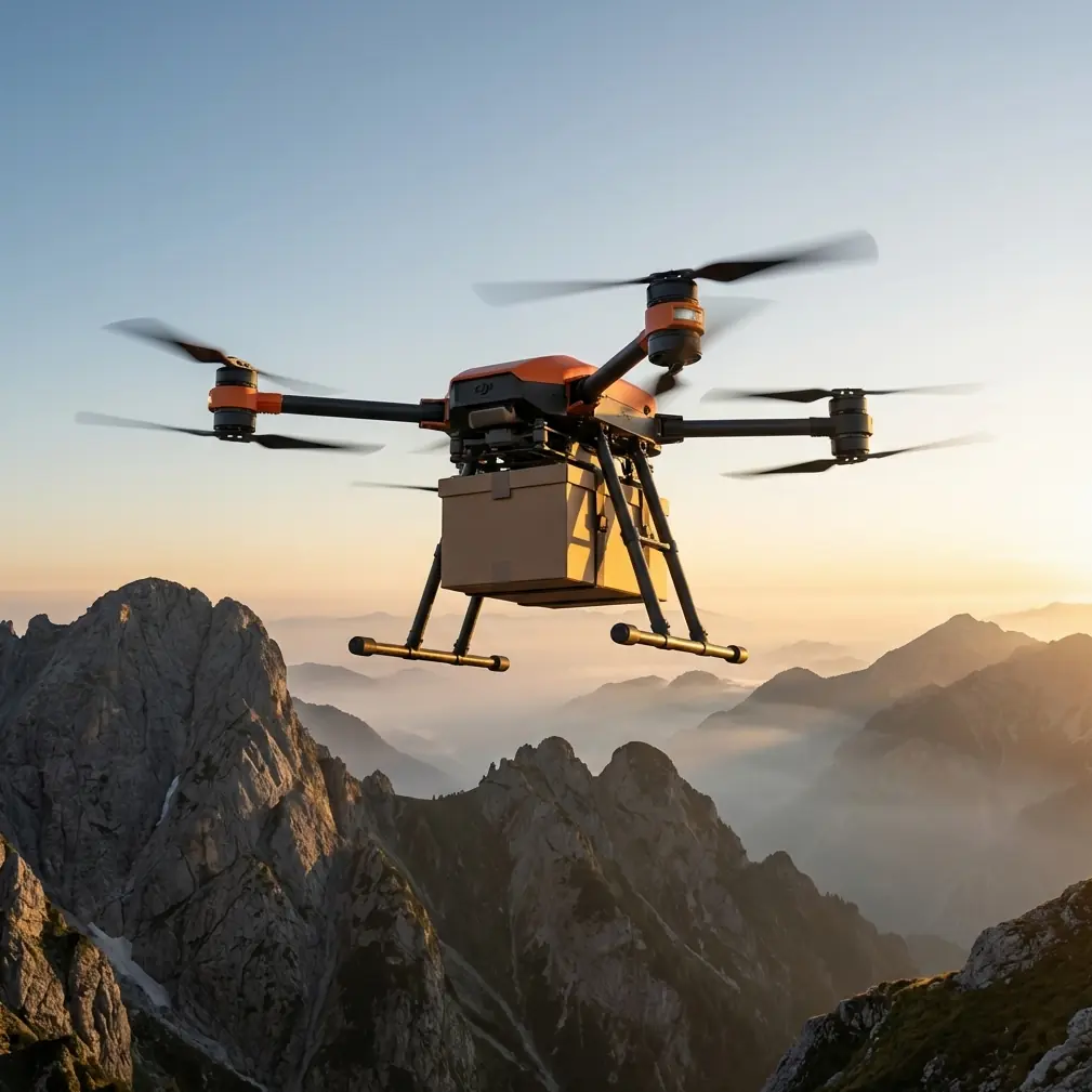
The FlyCart 30 supports a maximum takeoff weight of 95 kg with a maximum payload of 30 kg. That payload ratio changes what's possible on a construction site. Instead of sending a two-person crew on a 90-minute hike to place a survey prism, you fly it there in 8 minutes.
Common payloads for construction monitoring include:
- Terrestrial LiDAR units (typically 8–15 kg) for topographic surveys
- Concrete test cylinders transported from remote pour sites to the testing lab
- Replacement parts for heavy equipment stranded at inaccessible cut locations
- Environmental sampling kits for erosion control compliance
- Communications repeaters deployed to extend radio coverage across the site
The FlyCart 30's cargo box and external winch system give you flexibility to match the payload to the mission without reconfiguring the entire aircraft.
The Winch System: Precision Delivery Without Landing
This is where the FlyCart 30 separates itself from every other option on the market. The integrated winch system supports payloads up to 40 kg and lowers them with centimeter-level accuracy. On construction sites where flat, debris-free landing zones don't exist, the winch is not a luxury—it's a requirement.
I've used it to lower a 12 kg monitoring sensor package onto a bridge pier cap 65 meters below the drone's hover point. The alternative was a crane mobilization that would have cost the project two full days.
Expert Insight: When using the winch for deliveries near steel structures or rebar-heavy areas, keep the drone hover altitude at least 15 meters above the drop point. Magnetic interference from structural steel can affect the drone's compass at closer ranges. Program your hover waypoint accordingly in DJI Pilot 2.
Dual-Battery Architecture for Redundant Power
The FlyCart 30 runs on a dual-battery system with each battery rated at 38.6 Ah. This isn't just about extending flight time—though you get up to 28 minutes with a 30 kg payload and up to 45 minutes when flying light. The real value is redundancy.
If one battery fails or underperforms, the other sustains flight long enough to execute a controlled return-to-home. On an active construction site with workers, equipment, and open excavations below, that redundancy is non-negotiable.
Key battery specs at a glance:
- Flight time (no payload): Up to 45 minutes
- Flight time (30 kg payload): Up to 28 minutes
- Max operating range: 28 km (single flight, optimal conditions)
- Hot-swap capable: Yes—swap batteries without powering down the flight controller
BVLOS Operations and Route Optimization
The FlyCart 30 is engineered for BVLOS (Beyond Visual Line of Sight) flights, which is essential when your construction site stretches across multiple kilometers of uneven terrain. You plan a route once, validate it against your airspace authorization, and let the drone execute repeated sorties along the same optimized path.
Route optimization isn't just about drawing a line on a map. It involves:
- Terrain-following altitude profiles that maintain consistent ground clearance over ridges and valleys
- Wind corridor analysis to avoid known turbulence zones near cliff faces and building edges
- Geofenced exclusion areas around active crane swing radii, blasting zones, and helicopter landing pads
- Scheduled waypoint pauses for automated sensor data collection at predetermined survey points
I program routes using DJI FlightHub 2 and export them to the remote controller. Each route includes alternate landing sites every 2 km in case of weather deterioration or emergency recall.
Pro Tip: Set your route optimization software to add a 10% energy reserve buffer beyond the standard return-to-home calculation. Complex terrain generates unpredictable wind patterns, especially in afternoon thermal cycles. That buffer has saved me from emergency landings more than once.
Antenna Positioning: The Range Multiplier Nobody Talks About
Here's the advice that will save your operation before it starts: antenna positioning on the DJI RC Plus remote controller is the single most controllable variable affecting your communication range.
The FlyCart 30's remote uses dual antennas that emit a directional signal pattern. Most operators leave them in the default upright position and wonder why they lose signal behind a ridge. Follow these rules:
- Point the flat face of both antennas toward the drone's flight path. The signal radiates perpendicular to the antenna's flat surface, not from the tip.
- Maintain a clear line of sight from antenna to aircraft. Even partial obstruction from a vehicle cab or a portable office can cut effective range by 30–50%.
- Elevate your ground station. Position yourself on the highest accessible point at the site. A 3-meter increase in antenna elevation can add 2+ km of effective range in hilly terrain.
- Avoid placing the remote controller on metal surfaces. Truck hoods, steel containers, and scaffolding create reflective interference patterns that degrade signal quality.
- Use the external antenna kit for extended BVLOS missions. When flying routes beyond 8 km, the optional high-gain antenna array is the difference between a completed mission and a fly-away incident.
I set up a dedicated launch-and-recovery station on every project: a folding table at the site's highest point, away from metal structures, with a clear 270-degree horizon line toward the operational area. This simple setup has kept my signal strength above 80% on flights exceeding 16 km round-trip.
Technical Comparison: FlyCart 30 vs. Traditional Monitoring Methods
| Feature | FlyCart 30 | Helicopter Survey | Ground Crew Transport |
|---|---|---|---|
| Max Payload | 30 kg | 500+ kg | 25 kg per person |
| Deployment Time | 15 minutes | 2–4 hours | 1–3 hours |
| Operating Cost per Sortie | Low | Very High | Moderate |
| Terrain Limitation | Minimal | Weather dependent | Severe |
| Safety Risk | Low (emergency parachute) | Moderate | High (falls, fatigue) |
| Data Collection Integration | Built-in waypoint triggers | Requires separate system | Manual |
| BVLOS Capable | Yes | N/A | N/A |
| Turnaround Between Sorties | ~10 minutes (battery swap) | 30+ minutes (refuel) | Variable |
The FlyCart 30 doesn't replace helicopters for massive cargo lifts, and it doesn't replace ground crews for hands-on tasks. It eliminates the 70–80% of transport and monitoring tasks that fall in the gap between those two extremes—the missions that eat schedules alive.
Emergency Parachute System: Safety Over Active Sites
The integrated emergency parachute deploys automatically if the flight controller detects a critical failure. It's rated to safely decelerate the aircraft and its payload to a survivable descent rate even at maximum takeoff weight of 95 kg.
On construction sites, this isn't a checkbox feature. It's a contractual requirement on most Tier 1 projects. Safety officers won't approve drone operations over active work zones without a verified parachute recovery system.
The parachute triggers under these conditions:
- Dual motor failure on the same arm
- Complete loss of flight controller input
- Structural integrity compromise detected by onboard accelerometers
- Manual activation via the emergency button on the remote controller
After deployment, the system transmits the drone's GPS coordinates to the controller so recovery crews can locate it immediately.
Common Mistakes to Avoid
1. Ignoring wind patterns at different altitudes. Surface winds at your launch point might be calm while conditions at 120 meters AGL are gusting to 35 km/h. Always check wind forecasts at your planned flight altitude, not just ground level.
2. Overloading the payload without recalculating flight time. The relationship between payload weight and flight endurance is not linear. Adding 5 kg beyond your planned payload can cut flight time by 15–20%, potentially stranding the drone short of its destination.
3. Skipping pre-mission compass calibration in new locations. Construction sites are electromagnetically noisy environments. Rebar stockpiles, generators, and heavy equipment distort local magnetic fields. Calibrate the compass at your launch point before every session.
4. Flying identical routes without reviewing terrain changes. Excavation, grading, and new structures alter the terrain profile weekly. A route that cleared all obstacles on Monday might fly directly into a newly erected tower crane on Friday. Update your terrain model at least weekly.
5. Neglecting antenna orientation mid-flight. As the drone moves along a complex route, the optimal antenna angle changes. Assign a crew member to track the drone's position on FlightHub and rotate the controller to keep antennas oriented toward the active flight path.
Frequently Asked Questions
Can the FlyCart 30 operate in rain or snow on construction sites?
Yes. The FlyCart 30 carries an IP55 ingress protection rating, allowing operations in moderate rain, snow, and dusty conditions common on construction sites. However, visibility sensors and cameras may experience reduced performance in heavy precipitation, so plan accordingly.
How does route optimization work across terrain with significant elevation changes?
DJI's flight planning software allows you to import Digital Elevation Models (DEMs) of your site. The drone follows a terrain-relative altitude profile, maintaining your specified clearance above ground level rather than a fixed altitude above sea level. This is critical on sites with elevation changes exceeding 100 meters.
What regulatory approvals are needed for BVLOS construction monitoring flights?
Requirements vary by jurisdiction, but most authorities require a specific BVLOS waiver or exemption beyond the standard remote pilot certificate. You'll typically need to demonstrate detect-and-avoid capability, a robust communication link, and an emergency recovery plan. Work with your local aviation authority early—approval timelines can stretch to 60–90 days in some regions.
Ready for your own FlyCart 30? Contact our team for expert consultation.