FlyCart 30 for Urban Field Monitoring: A Case Study
FlyCart 30 for Urban Field Monitoring: A Case Study in Payload Discipline, Privacy Boundaries, and Safer Operations
META: A practical case study on using FlyCart 30 for urban field monitoring, with focus on payload ratio, winch workflows, dual-battery reliability, route planning, and privacy-conscious operations.
Urban field monitoring sounds simple until you try to do it properly.
You need repeatable coverage. You need to move sensors or collection gear into awkward spaces without blocking roads or sending crews across fenced lots. You need a platform that can work near buildings, utility lines, and mixed-use neighborhoods where a farming task can quickly become a privacy problem if the operation is not designed with discipline from the start.
That is where the FlyCart 30 becomes interesting.
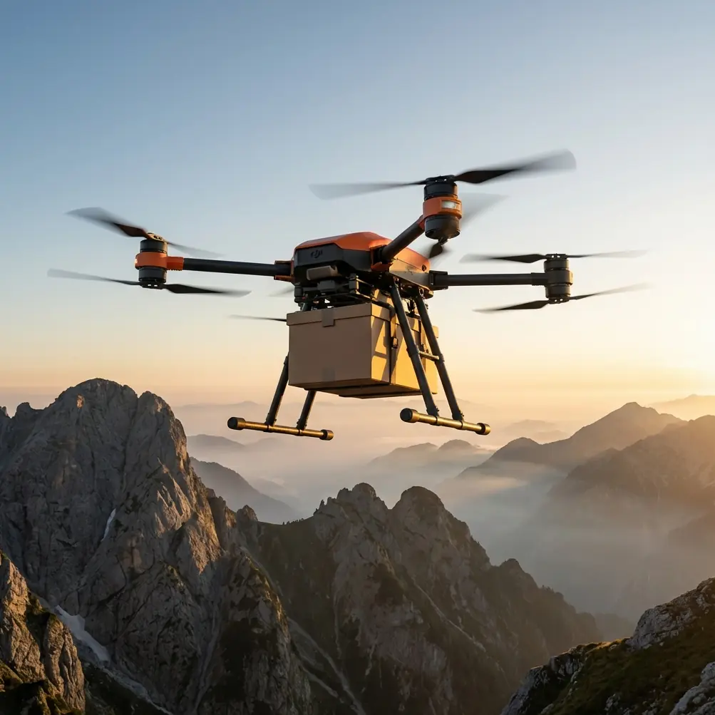
Most people look at the FC30 and think “cargo drone.” That is only half the story. In urban-edge agriculture, campus farming, rooftop plots, research fields, peri-urban greenbelts, and municipal horticulture sites, the more valuable question is this: can a transport-grade UAV reduce the friction of monitoring work without creating new legal and operational exposure?
As a logistics lead, I care less about brochure language and more about whether a platform helps a team complete a job with fewer handoffs, fewer site entries, and tighter control over what gets captured, moved, and recorded. For urban field monitoring, the FlyCart 30 has a real advantage because its payload architecture and winch workflow let teams bring the right tool to the field edge, deploy it precisely, and leave quickly. That is not just efficiency. In dense environments, it is risk management.
The urban monitoring problem most teams underestimate
A lot of drone planning for agriculture assumes open land and low population density. Urban field monitoring is different. The field may sit next to apartments, retail strips, pedestrian corridors, or public roads. A mission intended to inspect crop condition, irrigation status, or test plots can unintentionally point cameras toward people, homes, or private activity.
That matters more than many operators admit.
One recent photography article from chinahpsy made the point bluntly: image capture is not an unrestricted right simply because it happens in public-facing space. The piece warned that improper shooting can trigger consequences ranging from deleting images and apologizing to compensation for mental distress. In more serious cases, it said, administrative detention or even criminal liability may follow. Although the article addressed street photography rather than drones specifically, the operational lesson transfers directly to urban UAV work: the lens has boundaries.
For FlyCart 30 field monitoring, that means the mission design cannot be built around “capture everything and sort it later.” The workflow has to be narrow by design. The aircraft should support the monitoring task, not encourage broad incidental collection.
Why FlyCart 30 fits a monitoring workflow even though it is known for transport
The FC30 stands out against many competing UAVs because it is not trapped in a single-use identity. A lot of agricultural drones are optimized around one job profile. A lot of transport drones are discussed only in the context of delivery. The FlyCart 30 sits in a more useful middle ground for urban field operations.
Its payload ratio matters because monitoring is not always just about onboard imaging. Urban field teams often need to move lightweight sensor kits, sample containers, line droppers, temporary markers, communication nodes, or compact environmental instruments to difficult access points. If the aircraft can carry the tool and place it accurately, the monitoring network becomes more flexible. You are not forced to send a person into every location just because the measurement device is separate from the drone.
That is where the winch system becomes operationally significant. In urban-adjacent sites, landing is often the weak point. Ground surfaces are uneven, blocked, muddy, fenced, or crowded with irrigation fixtures and materials. A winch-equipped workflow allows the aircraft to remain clear of obstacles while lowering equipment into position. Compared with competitors that rely more heavily on direct touchdown or less refined drop procedures, the FC30’s approach can reduce disturbance on the ground and cut the chance of landing in a contaminated or restricted area.
For field monitoring, that creates a very practical chain of benefits:
- fewer full landings inside constrained plots
- less need for staff to enter sensitive or difficult terrain
- faster deployment of portable monitoring gear
- narrower camera exposure because the aircraft can hold a controlled position rather than search for a landing spot
The result is not just better logistics. It is cleaner compliance behavior.
Case study: monitoring trial plots beside a mixed-use district
Let’s use a realistic scenario.
A municipal horticulture team manages several trial plots on the edge of a city district. The plots support irrigation studies, soil amendment testing, and seasonal crop comparisons. The challenge is access. One parcel is bordered by a service road, one by residential buildings, and another by a commercial compound. Staff can enter on foot, but repeated site visits are slow, and some corners become difficult after rain.
The team initially considered a standard imaging drone. The problem was not the flight itself. The problem was everything around it.
The pilot would need to frame the scene carefully to avoid neighboring properties. The drone could collect images, but it could not easily deliver supplemental sensors to low-access areas. If a new moisture probe or micro-weather logger had to be installed, the crew still needed boots on the ground. Every extra site entry increased labor and extended the operation window near the public.
The FlyCart 30 changed the logic of the mission.
Instead of treating monitoring as a single drone flight, the team built a layered workflow:
- Pre-stage small field instruments and labeled sample containers.
- Use route optimization to define a narrow transit path that minimized overflight of sensitive edges.
- Deploy the FC30 with a controlled payload for each plot segment.
- Use the winch system to lower tools or retrieve samples without landing in the plot.
- Keep image collection limited to task-essential views, with the camera pointed to operational zones only.
- Exit the area quickly after placement or pickup.
This is where the FC30’s reputation for payload capability becomes more relevant than a pure mapping drone in some urban settings. The aircraft is not replacing every sensing task. It is compressing the support chain around monitoring.
The legal lesson from street photography applies here more than operators think
The chinahpsy article organized guidance into legal red lines, ethical no-go areas, and high-risk situations. That structure is unusually useful for FlyCart 30 operations in urban field environments.
Legal red lines
If a visual workflow captures people or private spaces unnecessarily, the operator may move from legitimate documentation into infringement territory. The article’s warning about outcomes such as image deletion, apologies, and compensation for mental distress is a reminder that “we were only recording the site” is not a reliable shield if the collection scope was careless.
For FC30 teams, this means:
- define the monitoring objective before takeoff
- restrict angles and hover points
- avoid broad sweeps across neighboring property
- retain only task-relevant data
Ethical no-go areas
Even when an action is technically possible, it may still be the wrong way to operate. In urban agriculture, trust with nearby residents and facility managers matters. A heavy-lift platform draws attention. If people believe it is filming them, you will burn operational goodwill fast.
The FlyCart 30’s strength here is that it can do productive work without pretending to be a cinematic survey platform. Use that advantage. Treat the aircraft as a logistics and precision-placement tool first. If imagery is necessary, collect the minimum needed to validate crop or equipment status.
High-risk situations
The article specifically framed some situations as more likely to create trouble. In an urban monitoring context, those include field edges near windows, sidewalks, schools, parking lots, and mixed residential-commercial boundaries. The FC30 does not remove those risks by itself. What it does offer is a mission profile that can shorten time over those areas and reduce unnecessary repositioning.
That is a major difference from smaller competitors that may need extra passes, closer approaches, or more improvised landing attempts when the mission also involves moving equipment.
Dual-battery architecture is not just a spec line
Urban field monitoring is full of partial missions. You may fly one route to deliver a sensor, another to retrieve a sample, and a third to verify an irrigation event. Reliability between those short tasks matters because interruptions are costly. If you have to halt the mission over a constrained site, reschedule, or send a ground crew in as backup, the efficiency gains disappear.
This is why dual-battery design has practical value. Operators often talk about battery systems in terms of endurance alone, but in real field logistics the bigger issue is continuity and confidence. A dual-battery setup supports a more resilient operating profile. When missions happen near roads, buildings, and sensitive boundaries, that resilience matters. You do not want an aircraft that turns every low-margin task into a high-anxiety event.
The same logic applies to emergency parachute capability. In an urban-edge field environment, contingency planning is not optional. A parachute system does not erase risk, but it changes the consequence profile in the event of a serious issue. For teams operating near people and structures, that is part of the safety case, not a marketing flourish.
BVLOS discussions need to be grounded in the site reality
Some readers looking at the FC30 will immediately think about BVLOS potential. Fair enough. But in urban field monitoring, BVLOS should never be treated as shorthand for “more productive by default.” The real question is whether the route design, communication environment, and regulatory framework support it safely and lawfully.
On distributed peri-urban plots, BVLOS can make sense when the operation is structured around narrow, predefined corridors and tightly controlled tasks such as equipment transfer or routine sensor servicing. The advantage is obvious: fewer repositionings of staff and more consistent route execution across multiple field segments.
Still, the better story with FlyCart 30 is not that it magically makes long-distance operation easy. The real strength is that it gives teams a serious logistics platform that can benefit from advanced route planning when the use case justifies it. In practice, route optimization often delivers more value than raw range claims because it reduces hover time, unnecessary turns, and indecisive positioning near sensitive boundaries.
That is exactly the kind of operational discipline urban field work requires.
Where FlyCart 30 genuinely excels over many alternatives
The FC30’s edge is not one isolated feature. It is the way several features combine.
A competitor may offer strong imaging. Another may offer transport capacity. Another may be easy to deploy. The FlyCart 30 becomes compelling for urban monitoring support because it blends payload ratio, precision placement through a winch system, dual-battery confidence, and safety-oriented mission planning into one platform.
That combination matters when your field is not a remote field.
If you need to monitor plots beside homes, business parks, service roads, or institutional campuses, the winning drone is not necessarily the one with the flashiest sensor headline. It is the one that helps you complete the monitoring workflow with fewer site intrusions, tighter task boundaries, and better control over what the aircraft does near the public.
For teams trying to design that kind of workflow, a direct operational discussion is often more useful than generic drone advice. If you want to compare route logic, payload setup, or privacy-aware deployment patterns for your site, you can reach out here: message Alex’s operations desk.
The bigger takeaway
Urban field monitoring is no longer just about getting airborne. It is about proving that the mission was necessary, proportionate, and carefully scoped.
The most useful insight from the photography reference is not legal fear. It is operational clarity. A camera, whether handheld or airborne, creates obligations. If careless image capture can lead to deletion of material, apology, compensation for mental distress, and in severe circumstances even administrative detention or criminal consequences, then drone teams should stop treating visual collection as an afterthought.
FlyCart 30 gives operators a better alternative. Build the mission around logistics precision, not visual excess. Use the payload capability to move what the field needs. Use the winch to avoid bad landings and unnecessary ground entry. Use route optimization to stay away from high-risk edges. Use dual-battery resilience and emergency parachute planning to tighten the safety case. And if imagery is part of the job, keep it narrow, deliberate, and directly tied to the agricultural objective.
That is how the FC30 becomes more than a transport drone. In the right urban field scenario, it becomes a disciplined monitoring support platform—one that respects both the crop and the boundaries around it.
Ready for your own FlyCart 30? Contact our team for expert consultation.