Monitoring Remote Forests With FlyCart 30: Why Trust
Monitoring Remote Forests With FlyCart 30: Why Trust, Visibility, and Pre-Flight Discipline Matter
META: Practical FlyCart 30 insights for remote forest monitoring, covering safety broadcasts, conspicuity, pre-flight checks, payload planning, winch operations, BVLOS workflow, and field reliability.
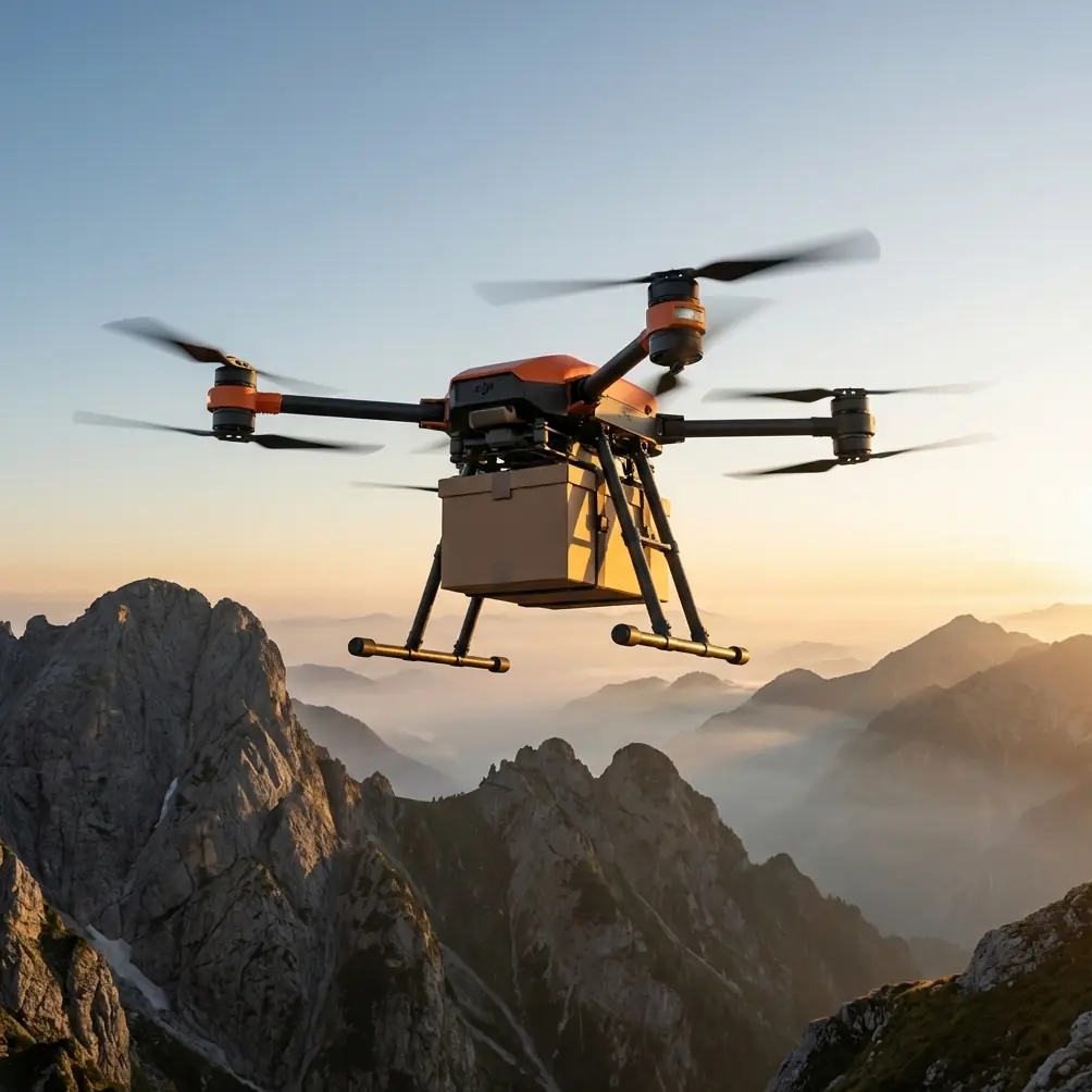
Remote forest monitoring looks simple on a slide deck. Put a drone in the air, send it beyond the ridge line, collect imagery or deliver sensors, and bring it home. In the field, it is messier than that.
Tree canopies distort depth perception. Mountain weather changes without warning. Ground teams work far from road access and often beyond reliable communications coverage. The aircraft is not just a camera platform in this setting. It becomes a logistics tool, an observation node, and sometimes the only practical way to move equipment between survey points. That is why the FlyCart 30 deserves a more serious discussion than a feature summary.
For forest work, the real question is not whether the platform can lift gear or follow a route. The deeper issue is whether crews can operate it with confidence when the mission stretches across isolated terrain and mixed airspace. A recent debate in aviation circles helps explain why this matters. On 2026-05-21, DroneLife highlighted AOPA’s public support for FAA Administrator Bryan Bedford’s opposition to ADS-B billing. At first glance, that sounds like a policy dispute centered on crewed aviation. It is bigger than that. The argument revolves around charging aircraft for ADS-B broadcasts, which are safety-related transmissions. Once safety broadcasts start feeling transactional, trust can erode. And when trust drops, universal conspicuity suffers for everyone sharing the sky, including uncrewed systems.
That point lands hard in remote forest operations.
Why a policy debate affects a FlyCart 30 mission in the woods
Forest monitoring crews often think first about terrain, payload, and battery endurance. They should. But airspace awareness belongs near the top of the list. Universal conspicuity is the principle that aircraft should be visible and predictable to one another. In a dense forest region with low-level crewed traffic, that matters more than many new operators realize.
Helicopters may be conducting utility inspection, wildfire assessment, medical access, or environmental work. Light aircraft may be transiting nearby valleys. A heavy-lift drone like the FlyCart 30, especially when supporting monitoring missions over distance, is part of that same safety environment. If the aviation community begins to distrust safety-related broadcasts because of billing models or fee structures, the downstream effect is not abstract. It can weaken the culture of voluntary participation and transparency that safer airspace depends on.
For a logistics lead, that translates into a practical rule: treat visibility, signaling, and procedural cleanliness as mission-critical, not optional. A FlyCart 30 in remote forest service is most effective when it fits into a workflow built around predictability.
The forest monitoring problem: access is hard, repetition is harder
Monitoring forests in remote areas is rarely a one-off flight. Most teams are repeating routes, revisiting plots, replacing edge sensors, collecting multispectral or thermal data, and transporting small tools or samples between field crews. The operational challenge is cumulative.
A team might need to move instruments into a steep section of woodland without building a trail. Then it may need to revisit the same point every week. The drone is no longer solving a single transport problem. It is supporting a repeatable system.
That is where FlyCart 30 stands out conceptually. It is not only about payload capacity. It is about payload ratio and mission design. In remote monitoring, every kilogram matters because it affects route planning, battery reserves, terrain margins, and whether the aircraft can safely complete a round trip with enough contingency left for changing conditions. A useful payload ratio means the platform can carry sensor kits, replacement power modules, trap-monitoring gear, or communications relays without turning each task into a separate sortie.
For forestry teams, that reduces field exposure. Fewer hike-ins. Fewer manual carries over unstable ground. Less time spent staging gear where weather can damage it.
The detail many crews skip: clean the safety hardware before every launch
There is a small pre-flight habit that deserves more attention than it gets: cleaning the safety-critical components before takeoff.
On a FlyCart 30 assigned to forest work, this is not cosmetic maintenance. It is risk control. Dust, pollen, pine resin, mud splash, and fine organic debris accumulate quickly in wooded environments. If your operation relies on an emergency parachute system, exposed sensors, landing gear interfaces, release mechanisms, or a winch assembly, contamination can change behavior at exactly the wrong time.
A pre-flight cleaning step should include the visible safety features and moving interfaces, not just the camera lens or airframe shell. Inspect the emergency parachute housing area for debris intrusion. Check the winch line path and hook zone for grit or snag points. Wipe down surfaces around sensors and status indicators that crews rely on during launch checks. Verify that battery contact areas are clean and dry before dual-battery installation.
This matters operationally for two reasons.
First, forest missions often launch from improvised clearings rather than ideal pads. That means the aircraft is more likely to ingest dust or pick up contamination during loading. Second, crews working in remote areas have fewer recovery options. A sticking release, obstructed mechanism, or dirty interface that might be manageable near a facility becomes far more disruptive when the nearest vehicle is an hour away.
The best operators build cleaning into the checklist, not the cleanup at the end of the day.
Why the winch system changes the mission geometry
A forest environment punishes direct landing. Uneven ground, brush, rocks, and hidden stumps make every touchdown more complicated than it appears from above. That is why a winch system can reshape the mission rather than merely add convenience.
For remote monitoring, the winch allows crews to keep the aircraft above obstacles while lowering equipment into narrow openings. You do not need a broad landing zone. You need a controlled drop zone. That can mean placing a sensor package into a canopy break, sending replacement batteries to a ridge crew, or extracting collected samples from a field team without forcing the aircraft to settle onto uncertain terrain.
The operational significance is easy to miss: the winch reduces the number of times the aircraft must physically interact with the forest floor. That lowers rotor exposure to loose debris and reduces landing risk in places where visual assessment is imperfect. It also speeds handoff cycles. In repeated monitoring operations, those minutes add up.
For route optimization, this means you can plan around hovering delivery points instead of full landing sites. In rugged forests, that creates more viable paths and more consistent turnaround times.
BVLOS only works when the trust chain is strong
Remote forest monitoring is one of the clearest civilian cases for BVLOS operations. Distances are long. Access is limited. Ground visibility is poor. If a drone can safely move along a predetermined route beyond the operator’s direct line of sight, the economics and practicality of the mission improve quickly.
But BVLOS is not just a regulatory box or a software capability. It is a trust chain.
You trust the route. You trust the aircraft status. You trust the communications link. You trust the people sharing nearby airspace to behave in ways that are legible. That is exactly why the discussion around ADS-B billing and safety broadcasts matters. DroneLife’s reporting pointed to broader concerns about universal conspicuity for both crewed and uncrewed aviation. That is not theory for forestry teams. It is a live operational concern.
A remote FlyCart 30 route over forests is safest when the surrounding airspace culture encourages participation in safety visibility, not reluctance. If pilots begin to treat broadcasts as something tied to charges rather than a shared safety practice, confidence degrades. The long-term effect can be a less transparent environment, which is bad news for BVLOS planning.
So while the FlyCart 30 may offer the hardware and workflow needed for remote logistics, operators should think beyond the aircraft. The mission standard has to include airspace awareness procedures that assume shared responsibility.
Dual-battery logic in cold mornings and long days
Forests create strange power conditions. Not electrically, but operationally. A mission may begin in cold dawn temperatures, pass into warm midday air, then end under shifting humidity. Equipment may sit idle while a field team relocates. Payloads vary from flight to flight. All of that complicates energy planning.
This is where a dual-battery approach has practical value beyond runtime. It supports mission continuity and resilience. In remote monitoring, you do not just want endurance. You want manageable field turnover. Swapping, balancing, and tracking battery health becomes part of your route system. A dual-battery configuration can help crews structure that process with more control, especially when each sortie carries meaningful operational overhead.
The significance for forest teams is simple: better energy management supports tighter route optimization. If you know your battery state and mission profile with confidence, you can assign tasks more precisely, preserve emergency margins, and avoid turning every unexpected delay into a mission cancellation.
Build routes around terrain truth, not map optimism
On a screen, a forest route can look clean. In reality, canopy height changes, wind tunnels through saddles, and localized fog all alter performance. FlyCart 30 missions for monitoring work should be designed around terrain truth rather than idealized software lines.
That means identifying hover transfer points for the winch, establishing conservative return thresholds, and sequencing deliveries or pickups so the heaviest or most sensitive segment happens when batteries are strongest and weather confidence is highest. Payload ratio matters here because route design is only as good as the load assumptions behind it.
A common mistake is planning one route for all forest tasks. Better practice is to create route families:
- sensor deployment routes
- field resupply routes
- retrieval routes
- post-storm inspection routes
Each has different payload behavior, risk concentration, and turnaround timing.
Safety systems are there for the rare day, not the routine day
Operators sometimes get complacent with safety features when missions become repetitive. That is backwards. The emergency parachute is not a badge feature. In remote forests, it is there for the rare day when something does not go to plan over terrain that offers very few forgiving outcomes.
That makes pre-flight verification and cleaning even more important. If you are counting on an emergency system as the final layer, it deserves the same attention as propulsion and batteries. Do not let “we flew this route yesterday” become the reason you skip inspection discipline today.
Human workflow still decides whether the platform succeeds
The FlyCart 30 can be a strong fit for remote forest monitoring, but the aircraft alone does not create a reliable operation. The successful teams are the ones that combine airframe capability with clean procedures:
- inspect and clean safety-critical hardware before launch
- use the winch to avoid unnecessary landings
- plan BVLOS routes with conspicuity and shared airspace awareness in mind
- manage dual-battery cycles as part of route logic, not as an afterthought
- evaluate payload ratio against terrain and weather, not just task demand
That is the difference between flying a capable drone and running a dependable forest logistics system.
If your team is refining a remote monitoring workflow and wants to compare route concepts or payload handling approaches, you can message a FlyCart specialist here.
The bigger lesson from the recent aviation debate is worth carrying into every forest operation. Safety visibility only works when participants trust the system enough to use it willingly and consistently. For FlyCart 30 crews, that means technical readiness and airspace responsibility belong in the same conversation. In remote forests, where distance magnifies every small mistake, that mindset is not extra discipline. It is the job.
Ready for your own FlyCart 30? Contact our team for expert consultation.