FlyCart 30 in Complex Terrain: What a Tibet Rescue
FlyCart 30 in Complex Terrain: What a Tibet Rescue Helicopter Drill Reveals About Smarter Venue Monitoring
META: A practical FlyCart 30 guide for monitoring venues in complex terrain, using lessons from a recent road-cutoff rescue drill to explain altitude, route planning, winch use, BVLOS, and dual-battery strategy.
When a city runs a disaster-response drill around a simple but brutal constraint—roads are cut off—you learn something useful about aircraft selection fast.
A recent exercise in Shigatse centered on exactly that problem. The city’s first rescue helicopter completed a drill using a high-power Mi-171 emergency rescue platform. The scenario simulated a disaster in Kangmar County where road access was interrupted, and the whole point of the exercise was to test rapid response when ground transport could no longer do the job.
That story is not about the FlyCart 30 on paper. It is about the operating environment that makes aircraft matter.
If you are responsible for monitoring venues in complex terrain—mountain event sites, remote festival grounds, temporary work zones, ridge-adjacent construction venues, or dispersed logistics points—the underlying operational problem is the same. Ground access is fragile. Visibility changes by the minute. Terrain blocks line of sight. A route that looks short on a map can become useless after weather, congestion, or a slope failure.
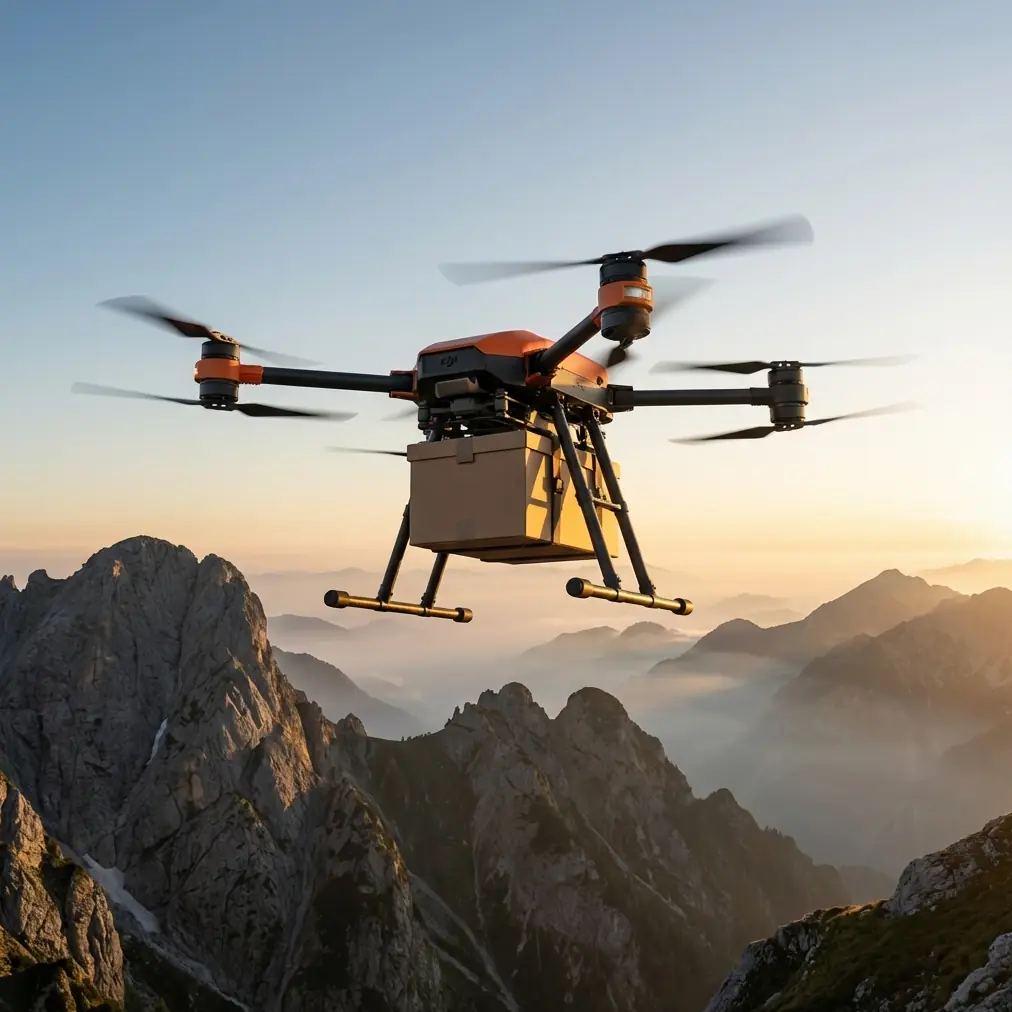
That is where the FlyCart 30 becomes interesting. Not because it replaces a rescue helicopter. It does not. The significance lies elsewhere: it gives civilian operators a practical way to maintain situational awareness, move lightweight critical supplies, and keep eyes on priority zones when roads, footpaths, and normal vehicle circulation become unreliable.
As a logistics lead, I look at the Shigatse drill and see a familiar truth. The aircraft is only half the story. The real issue is continuity of operations after access breaks down.
The terrain problem most venue teams underestimate
Monitoring a venue in flat open land is mainly a coverage problem. Monitoring a venue in broken terrain is a geometry problem.
Hills, gullies, ridgelines, retaining walls, trees, temporary structures, and weather pockets all change what your aircraft can see and how safely it can move. In these environments, the common mistake is to fly too low too early because low altitude feels closer, and closer feels safer. It often is not.
The rescue drill in Kangmar County matters because it was designed around a road interruption. That detail has direct operational significance for FlyCart 30 users. Once roads are cut off, your drone mission is no longer just about observation. It becomes a continuity tool. You may need to verify whether a perimeter road is passable, inspect crowd egress routes, deliver radios or medical kits to an isolated checkpoint, or maintain oversight of a venue sector that staff cannot reach quickly by vehicle.
The FlyCart 30’s value in that setting comes from its ability to work as a transport-and-observation asset in terrain that slows everything else down.
Why altitude discipline matters more than raw range
For complex-terrain venue monitoring, the best flight altitude is rarely the lowest legal or the highest comfortable one. It is the altitude that clears local obstructions with margin while preserving stable route geometry.
My practical rule is simple: for ridge-cut or slope-adjacent venues, start by identifying the tallest terrain or structure likely to affect your path, then build a buffer that allows the aircraft to avoid repeated climb-and-drop corrections. In many venue environments, that means flying high enough to stay above localized obstacles and terrain turbulence, but not so high that visual detail and drop precision suffer.
The FlyCart 30 is especially sensitive to this tradeoff because it is not just carrying sensors. It may be carrying cargo, and cargo changes how vertical maneuvering affects efficiency and control. Every unnecessary climb consumes time and battery. Every aggressive descent near a slope can complicate stability.
So the optimal altitude insight here is this: in complex terrain, choose an altitude based on terrain continuity, not just target visibility. A smoother, more predictable flight layer usually delivers better monitoring results than a lower, more dramatic path that forces constant corrections.
That matters even more in a road-cutoff scenario like the one simulated in Shigatse. If your ground team cannot reposition quickly, your aircraft route must be conservative, repeatable, and easy to redeploy. You do not want a mission profile that only works when one pilot with local terrain memory is on shift.
Payload ratio is not just a spec-sheet talking point
One of the most overlooked planning issues for venue monitoring is payload ratio. Teams often think in binary terms: either the drone carries something or it does not. In reality, the ratio between payload and mission duration drives what kind of operation you can sustain.
In a complex-terrain venue environment, payload may include more than emergency items. It can mean spare batteries for field sensors, radios for isolated stewards, first-aid packs, inspection tools, or temporary communications equipment. If the aircraft is tasked with both monitoring support and light logistics, payload discipline becomes central.
This is where the FlyCart 30 earns its place. Its design logic fits missions where transport is part of situational awareness. If a route is blocked, the fastest way to understand what is happening may be to put the right item into the right person’s hands without waiting for a vehicle detour.
Operationally, that shortens the loop between observation and action.
The rescue helicopter drill in Shigatse validated rapid response under road interruption. For FlyCart 30 operators, the takeaway is smaller in scale but no less practical: if your venue plan assumes every critical point remains reachable by cart, pickup, or foot team, your plan is fragile. A drone with a strong payload-to-mission balance gives you a backup layer.
The winch system changes how you use terrain, not just how you deliver cargo
In steep or obstructed areas, landing is often the least efficient part of the mission. Sometimes it is the least safe part too.
That is why the FlyCart 30’s winch system has real operational significance for venue monitoring in difficult topography. It lets the aircraft deliver to or retrieve from a point without committing to a full landing zone search. On paper, that sounds like a convenience feature. In the field, it can be the difference between a viable route and a cancelled mission.
Imagine a temporary monitoring post set on uneven ground above a spectator corridor, or a staff location near a slope edge where rotor clearance and touchdown conditions are poor. A controlled lowering operation can keep the aircraft in a cleaner hover position while reducing the need to place the airframe into a constrained touchdown environment.
This matters in any scenario resembling the road-disruption drill from Kangmar County. If ground access is interrupted, the locations that remain occupied may be the least accessible ones. A winch-equipped transport workflow gives venue managers a way to sustain those positions without forcing personnel movement through compromised routes.
BVLOS is useful only when route optimization is mature
People talk about BVLOS as if it automatically solves distance. It does not. In complex terrain, BVLOS without disciplined route optimization just expands the radius within which poor planning can happen.
The real advantage comes when routes are built around terrain logic, communication continuity, and delivery priorities. For venue monitoring, that means separating missions into categories:
- perimeter verification
- isolated-point supply
- elevated observation passes
- contingency response when foot or vehicle movement is delayed
The FlyCart 30 is most effective when each route type has a defined altitude band, preferred corridor, fallback path, and battery reserve threshold. That structure matters because terrain creates asymmetry. An outbound leg may be easy. The return leg, with changing wind over a ridge or a different payload state, may not be.
The Shigatse exercise underscored rapid response under disrupted access. For a commercial operator, the equivalent lesson is route pre-planning before disruption happens. Once a venue road is blocked or a weather cell shifts across a valley, you are not designing the network from zero. You are selecting from rehearsed options.
If your team is building those workflows for a mountain venue or other hard-access site, I’d suggest comparing route templates and deployment logic with operators who work these scenarios regularly through this field discussion channel: https://wa.me/85255379740
Dual-battery thinking is really continuity thinking
The dual-battery concept is often reduced to endurance. That is too narrow.
For terrain-heavy operations, dual-battery architecture supports predictability. It gives teams more confidence to preserve reserve margins rather than chasing every last minute of flight time. That is crucial in venue monitoring because your mission may change mid-flight. A routine perimeter sweep can become a support run to an isolated checkpoint, or an inspection pass can become a verification task after a rockfall or crowd diversion.
With a road-cutoff scenario, reserve planning becomes a first-order issue. The entire point of the rescue helicopter drill was to test response when normal access failed. For FlyCart 30 operators, the comparable discipline is to treat battery reserve as a mobility substitute. Your reserve is what allows the aircraft to absorb a sudden tasking shift when trucks or personnel cannot.
That is why I advise teams not to plan to the edge of nominal endurance in mountainous venues. The smarter standard is to preserve enough energy for route deviation, hover stabilization during winch work, and an unplanned reposition to a safer recovery point.
Emergency parachute logic belongs in venue risk design
A lot of drone articles mention emergency parachutes as a checklist item. That misses the point.
In a complex venue environment, the significance of an emergency parachute is not abstract compliance. It is risk compartmentalization. When you are operating near temporary public infrastructure, event assets, work crews, or limited-access terrain corridors, you need a credible last-resort measure that fits the reality of where the aircraft is flying.
For FlyCart 30 operations, that means the parachute should not be treated as a permission slip to take aggressive routes. It should support route design that already minimizes exposure to populated or constrained zones. In practice, that often means keeping transport corridors offset from dense activity areas where possible, even if the route is slightly longer.
The better your route optimization, the less often your emergency systems become part of the operational conversation. That is exactly how it should be.
What the Mi-171 drill tells FlyCart 30 teams to rehearse
The detail that stands out from the Shigatse report is not just that a helicopter flew. It is that the exercise focused on a specific failure mode: disaster-led road interruption in Kangmar County. That specificity is what made the drill meaningful.
FlyCart 30 teams should copy that mindset.
Do not rehearse “general emergency response.” Rehearse one credible venue failure at a time.
For example:
- the service road to the upper venue sector is blocked
- a slope-side monitoring team cannot descend safely
- temporary communications equipment is needed at an isolated checkpoint
- visual confirmation is required over a route inaccessible by vehicle
- weather reduces usable corridors and forces a reroute
Each of those should have a predefined FlyCart 30 profile: altitude band, payload limit, use of winch or direct landing, reserve threshold, and recovery point.
That is how a drone becomes part of venue resilience rather than just an interesting aviation tool.
The practical operating model
If I were structuring a FlyCart 30 deployment for monitoring venues in complex terrain, based on the lesson from this road-cutoff rescue drill, I would keep it simple:
First, map the venue in terms of access fragility, not just geography. Which sectors fail first when roads, stairs, or footpaths become unusable?
Second, establish a preferred flight altitude that prioritizes terrain clearance consistency. Do not optimize for dramatic proximity. Optimize for predictable coverage and repeatability.
Third, assign route families rather than one-off missions. Observation, delivery, verification, and contingency should not share identical assumptions.
Fourth, use the winch system to reduce dependence on landing zones in awkward terrain.
Fifth, maintain battery reserve as a response buffer, not an afterthought.
Sixth, build every route as though access could be interrupted halfway through the operating day—because in mountainous or broken terrain, that is usually the real test.
The Shigatse helicopter exercise showed what emergency planners already understand: when roads fail, time compresses and access becomes the problem behind every other problem. The FlyCart 30 fits below that scale, but squarely inside that logic. For venue operators, infrastructure teams, and logistics managers, that makes it more than a cargo drone. It becomes a controlled way to preserve visibility and movement when terrain starts taking options away.
Ready for your own FlyCart 30? Contact our team for expert consultation.