FlyCart 30 Monitoring Guide: Best Practices for Wildlife
FlyCart 30 Monitoring Guide: Best Practices for Wildlife Work in Complex Terrain
META: A practical FlyCart 30 guide for wildlife monitoring in difficult terrain, covering route planning, winch use, weather shifts, payload strategy, and why new UAV certification milestones matter.
Wildlife monitoring looks simple on a map. In the field, it rarely is.
A ridge line cuts your radio path. A marsh blocks vehicle access. The weather holds for twenty minutes, then shifts just enough to turn a routine supply drop into a test of planning. When your team is operating in complex terrain, the aircraft matters, but the operating method matters more. That is where the DJI FlyCart 30 becomes interesting—not as a spec-sheet trophy, but as a working platform for moving field sensors, bait-free camera kits, acoustic recorders, medical supplies for research teams, and small utility payloads into places people should not need to hike repeatedly.
I’m writing this from the perspective of logistics, because that is usually where wildlife projects either stay efficient or start bleeding time. If you are evaluating the FlyCart 30 for monitoring missions, especially in mountainous, forested, wetland, or mixed-elevation environments, the best approach is to think beyond payload capacity alone. Focus on payload ratio, route optimization, weather response, and how the winch system changes the shape of your operation.
There is also a larger industry signal worth paying attention to. Recent aviation news out of China highlighted that the E40H civil unmanned aircraft system received a type certificate on December 30, 2025, issued by the Civil Aviation Administration of China’s Central and Southern Regional Administration under certificate number TC0105A-ZN. That matters for anyone operating heavy or mission-critical drones, even if you are not flying that exact aircraft. Why? Because the E40H was reported as the world’s first medium-sized compound-wing and hybrid-power unmanned aircraft in its class to satisfy regulator airworthiness requirements. It also became a notable outlier among the 19 civil unmanned aircraft models from 10 Chinese companies that have received type certificates so far, since most approved models have been multirotor agricultural systems, with 9 of those 19 from DJI.
For FlyCart 30 operators, that certification milestone reinforces a practical truth: the commercial UAV market is moving toward more formal proof of design safety and operational reliability, especially for larger aircraft used in transport, emergency support, and extended missions. Wildlife monitoring in remote terrain may sound softer than logistics or industrial delivery, but from an operations standpoint, the requirement is similar. You need aircraft systems that can deal with real-world variables, not just clean test flights.
Start with the mission, not the aircraft
The most common mistake I see is teams choosing the flight profile before defining the field problem. Wildlife monitoring missions with FlyCart 30 tend to fit into four categories:
- Delivering camera traps, batteries, data cards, or acoustic devices
- Recovering collected samples or equipment from inaccessible points
- Resupplying remote researchers without repeated foot access
- Supporting temporary sensor deployment across a large survey area
Each one creates a different demand on the aircraft.
If your team is placing camera traps on steep slopes, the winch system may matter more than a hard landing zone. If you are distributing multiple sensor nodes over a long route, route optimization becomes the main productivity driver. If your teams are monitoring species in weather-sensitive highland zones, the dual-battery philosophy and emergency parachute features matter because your real risk is not lift capacity. It is degraded decision margin when conditions change.
That distinction is worth emphasizing. In remote ecology work, a drone is often not replacing a truck. It is replacing a risky walk, a rope-assisted descent, or a full day of labor.
Why payload ratio matters more than headline payload
People love maximum payload numbers, but payload ratio is the more useful planning metric.
By payload ratio, I mean the relationship between what you are carrying and what you are sacrificing to carry it—range, altitude margin, weather tolerance, turnaround speed, and battery reserve. In wildlife work, overloaded flights are rarely necessary. Poorly balanced flights are far more common.
A smart FlyCart 30 loadout keeps the aircraft in a range where it can still handle terrain-induced gusts, partial signal shadowing, and minor route deviations without turning the mission into a battery management exercise. A lighter, more stable payload package often delivers better field outcomes than pushing the aircraft closer to its upper transport capability.
For example, a camera trap deployment kit can usually be redesigned. Hard cases become soft weather-resistant packs. Mounting hardware is standardized so the field team does not carry duplicate tools. Power banks are selected for deployment time rather than excessive reserve. Those decisions improve payload ratio and reduce time on the aircraft.
In wildlife operations, payload discipline has a direct ecological benefit too. The faster and cleaner the drop, the less disturbance you create around the monitoring site.
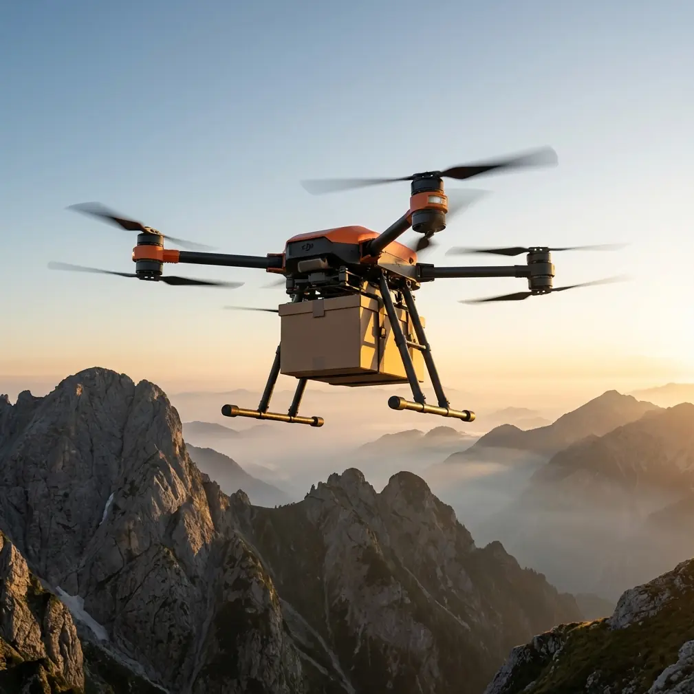
Use the winch system to keep the aircraft out of trouble
The winch system is one of the most operationally significant features for complex terrain. Not because it looks advanced, but because it removes the need to land where landing is a bad idea.
That has real value in wildlife monitoring. Many target sites are surrounded by brush, uneven rock, tree roots, mud, or fragile habitat. Landing a transport drone there may be impossible or simply irresponsible. A controlled suspended delivery lets the aircraft hover over a safer point while lowering the payload precisely to a field worker or to a marked drop zone.
The significance is bigger than convenience. It changes your risk profile.
A winch-assisted delivery can:
- Keep rotor wash away from fragile ground cover
- Reduce entanglement risk near brush or loose branches
- Shorten time spent hunting for a usable landing patch
- Limit disturbance near nesting or denning areas
- Improve safety in steep or wet terrain where takeoff and landing margins are poor
For wildlife teams, this becomes especially useful when rotating batteries for remote camera arrays or replacing acoustic monitors after storms.
A mid-flight weather shift: what the plan should look like
Here is a realistic scenario.
You launch in stable morning conditions to move two compact acoustic monitoring kits and one battery pack to a ridge-edge relay point. The route was planned with terrain clearance and a conservative reserve. Halfway through the second leg, the wind changes. Not dramatic. Just enough to produce lateral instability along the slope face and a more variable descent profile near the drop point.
This is where teams either trust the original plan too much or start improvising badly.
The better FlyCart 30 response is procedural:
- Reassess the drop, not just the route
- Switch from landing intent to winch delivery if the site has become unstable
- Recompute return margin based on current power consumption rather than launch assumptions
- Adjust the approach angle to reduce exposure to terrain-driven gusts
- Keep the aircraft high enough to preserve obstacle clearance if visual contrast is deteriorating
In practical terms, the dual-battery setup matters here because it supports operational resilience during changing conditions. It is not a license to push deeper into bad weather. It gives you more decision space when weather turns from “acceptable” to “watch this carefully.” That is exactly the kind of margin wildlife field teams need, because many mission areas have no easy recovery road and no nearby alternate landing surface.
If the weather shift continues, the best decision is often to complete only the most essential drop, then return and re-task later. Good drone logistics is not about squeezing every leg out of a flight. It is about preserving aircraft availability and keeping the survey schedule intact over days or weeks.
BVLOS thinking begins long before BVLOS approval
Many teams use the term BVLOS as shorthand for long-distance capability. That is too casual.
For wildlife monitoring, BVLOS thinking should begin at the planning desk even if your operation remains within local visual or procedural limits. Why? Because the same planning discipline improves every mission: terrain modelling, radio path awareness, waypoint logic, emergency alternates, and clear lost-link behavior.
This is where the broader certification trend becomes relevant again. The E40H’s recent airworthiness milestone signals where larger commercial UAV operations are heading: more scrutiny on system reliability, more attention to aircraft design safety, and more structured operational expectations. That should influence how FlyCart 30 operators build their own SOPs.
If you are preparing for extended terrain missions, write your procedures as if every flight may later need to stand up to formal operational review. That means documenting:
- Payload configuration
- Battery condition
- Weather thresholds
- Route logic
- Emergency parachute criteria
- Ground team positioning
- Recovery decision points
The emergency parachute deserves a specific mention here. In remote field work, it is easy to frame parachute systems as purely last-resort technology. They are, but their value is strategic as well. They support a safer operating envelope around inaccessible terrain by adding one more mitigation layer if a severe failure occurs. That does not replace route discipline or conservative flying. It strengthens the overall risk architecture.
Route optimization is where projects save real time
The most efficient wildlife monitoring teams do not just fly shorter routes. They build smarter sequence logic.
With FlyCart 30, route optimization should account for:
- Elevation changes, not just map distance
- Wind exposure by segment
- Drop order by payload priority
- Empty-leg return efficiency
- Battery swap timing
- Field team readiness at each point
A simple example: if one delivery point sits in a wind funnel and another is sheltered but farther away, the sheltered site may actually belong first in the sequence if weather is expected to deteriorate. Likewise, if one site requires winch precision and another allows a faster handoff, you may save battery and reduce hover time by reversing the original order.
This is where a logistics lead adds value to conservation work. Better route design means fewer total flights, less habitat disturbance, and more staff time spent collecting data instead of moving supplies.
What the current certification landscape tells FlyCart 30 buyers and operators
The Chinese civil UAV certification data in the recent report is more than an industry footnote. It shows how selective formal aircraft approval still is.
Only 19 civil unmanned aircraft models from 10 companies have received type certificates so far, and the market has been dominated by multirotor agricultural aircraft. The fact that the newly certified E40H stands out as the first medium-sized compound-wing and hybrid-power model in that approved pool is significant operationally. It suggests that heavier, more complex civilian UAV platforms are crossing from technical promise into documented compliance.
For FlyCart 30 users, the lesson is not to compare unlike aircraft directly. It is to recognize that reliability, certification culture, and operational standardization are becoming central to commercial drone adoption. If your organization plans to use FlyCart 30 for recurring wildlife support missions, especially in environmentally sensitive or logistically difficult regions, build your program around documented procedures, maintenance discipline, and mission repeatability. Those are no longer optional habits for serious operators.
Field checklist for wildlife teams using FlyCart 30
Before deployment, I recommend a short but strict workflow:
1. Define the ecological objective
Know whether the flight is reducing human disturbance, accelerating sensor setup, or solving access limitations. That affects route and drop design.
2. Right-size the payload
Aim for balance, not maximum lift. Protect your reserve margin.
3. Prefer winch delivery where terrain is poor
If the landing zone is marginal, do not force the aircraft onto the ground.
4. Build weather decision points in advance
Do not decide your wind tolerance after takeoff.
5. Assign ground coordination roles
One pilot, one payload receiver or visual support contact, one mission coordinator if the operation is layered.
6. Record every anomaly
Power draw changes, hover instability, route deviations, and difficult recovery events all improve future planning.
If your team is comparing deployment methods or wants a practical discussion around terrain-specific setup, this direct field contact can help: https://wa.me/85255379740
The real value of FlyCart 30 in wildlife monitoring
The FlyCart 30 is most useful when it removes friction from the field operation. Not when it is treated as the center of the story.
In complex terrain, its value comes from combining transport capability with precision delivery options, safer stand-off handling through the winch system, and the kind of redundancy-minded thinking reflected in dual-battery and emergency parachute planning. Pair that with disciplined route optimization and you get a platform that can help wildlife teams monitor more ground with less intrusion.
That is the larger operational takeaway from the recent certification news as well. As civil UAV systems become more formalized and airworthiness expectations rise, the organizations that benefit most will be the ones already treating drones as serious field infrastructure rather than occasional gadgets.
For wildlife monitoring, that shift is overdue. Good data collection depends on consistency. So does safe drone logistics.
Ready for your own FlyCart 30? Contact our team for expert consultation.