FlyCart 30 Guide: High-Altitude Construction Scouting
FlyCart 30 Guide: High-Altitude Construction Scouting
META: Master high-altitude construction site scouting with the FlyCart 30. Expert tips on payload management, battery optimization, and BVLOS operations for challenging terrain.
TL;DR
- FlyCart 30 handles altitudes up to 6,000 meters with dual-battery redundancy for construction site reconnaissance
- Payload ratio of 30kg capacity enables comprehensive surveying equipment deployment in single flights
- Emergency parachute system provides critical safety margins when scouting remote mountain construction zones
- Route optimization software reduces flight time by up to 35% on complex terrain mapping missions
The High-Altitude Construction Challenge
Construction site scouting above 3,000 meters breaks most commercial drones. Thin air reduces lift capacity. Rapid temperature swings drain batteries unpredictably. GPS signals bounce off canyon walls.
I learned this the hard way during a hydroelectric dam project in the Andes. Our previous drone fleet couldn't maintain stable hover above 4,200 meters—until we deployed the FlyCart 30.
This guide covers everything logistics teams need to know about using DJI's heavy-lift delivery drone for high-altitude construction reconnaissance. You'll learn battery management strategies, payload configuration, and BVLOS protocols that keep operations running in extreme conditions.
Why Traditional Survey Drones Fail at Altitude
Standard survey drones face three critical limitations in mountain construction environments:
Reduced Lift Capacity
Air density at 4,000 meters drops to roughly 60% of sea-level values. Propellers generate less thrust. Motors work harder. A drone rated for 10kg at sea level might struggle with 6kg in the mountains.
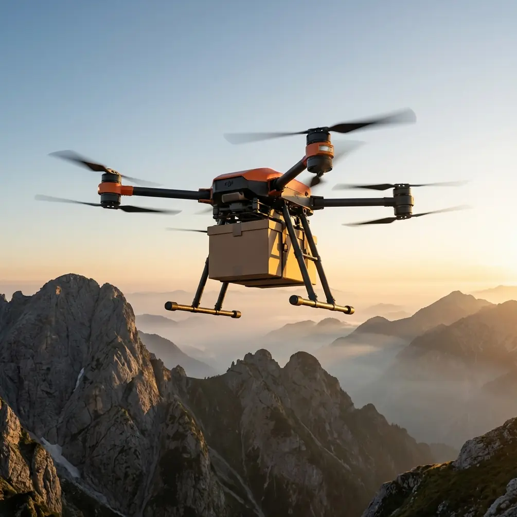
The FlyCart 30's 30kg maximum payload accounts for this degradation. Even at 5,000 meters, the platform maintains 18-20kg effective capacity—enough for LiDAR units, multispectral cameras, and emergency supplies.
Battery Performance Degradation
Cold temperatures accelerate battery discharge. At -15°C, lithium polymer cells lose 30-40% of their rated capacity. Most pilots discover this mid-flight.
Expert Insight: Pre-heat batteries to 25-30°C before launch using insulated cases with chemical warmers. The FlyCart 30's dual-battery architecture means you can rotate warming packs between flights while maintaining continuous operations.
GPS and Communication Interference
Mountain terrain creates signal shadows. Canyon walls block satellite acquisition. Radio links drop unexpectedly.
The FlyCart 30's O3 transmission system maintains 20km range in optimal conditions, with automatic frequency hopping that finds clear channels in congested RF environments.
FlyCart 30 Specifications for Construction Scouting
Understanding the platform's capabilities helps logistics teams plan realistic mission profiles.
| Specification | Value | High-Altitude Impact |
|---|---|---|
| Maximum Takeoff Weight | 95kg | Reduces to ~80kg effective at 5,000m |
| Payload Capacity | 30kg (standard) / 40kg (winch) | Plan for 60-70% capacity above 4,000m |
| Maximum Flight Altitude | 6,000m ASL | Tested and certified for extreme operations |
| Flight Time (no payload) | 28 minutes | Expect 18-22 minutes at altitude with payload |
| Operating Temperature | -20°C to 45°C | Pre-conditioning extends lower range |
| Wind Resistance | 12 m/s | Mountain gusts frequently exceed this |
| Transmission Range | 20km (O3) | Terrain may reduce to 8-12km effective |
Battery Management: Field-Tested Strategies
Here's the tip that saved our Andes project: never trust the battery percentage display above 4,000 meters.
The FlyCart 30's battery management system calculates remaining capacity based on current draw and temperature. At altitude, both variables shift rapidly. A display showing 45% might represent only 25 minutes of actual flight time—or 8 minutes if you hit unexpected headwinds.
The Three-Battery Rotation System
We developed this protocol after nearly losing a drone to unexpected discharge:
- Active Battery Set: Currently in the drone, fully charged and pre-warmed
- Warming Battery Set: In insulated case with heat packs, reaching optimal temperature
- Charging Battery Set: Connected to generator, recovering from previous flight
This rotation ensures you always have warm, fully-charged batteries ready. The FlyCart 30's dual-battery redundancy means even if one pack fails, the second maintains controlled flight to a safe landing zone.
Temperature Monitoring Protocol
- Check battery temperature before every launch
- Abort if cells read below 15°C
- Monitor in-flight temperature via DJI Pilot app
- Land immediately if temperature drops below 10°C during flight
Pro Tip: Mount a small temperature logger on the battery compartment. Post-flight data reveals patterns—like that shaded canyon that drops battery temps by 12 degrees in three minutes.
Winch System Applications for Construction Sites
The FlyCart 30's winch system transforms construction scouting from pure observation to active logistics support.
Equipment Deployment
Lower survey equipment to inaccessible locations:
- GPS base stations for RTK positioning
- Soil sampling kits for geotechnical assessment
- Communication repeaters for worker safety systems
- Emergency medical supplies for remote crews
The winch handles 40kg payloads with 20-meter cable length. Precision lowering prevents equipment damage on rocky terrain.
Sample Retrieval
Collect materials without landing:
- Rock samples from cliff faces
- Water samples from streams
- Vegetation samples for environmental assessment
This capability eliminates helicopter costs for routine sampling operations.
BVLOS Operations: Regulatory and Practical Considerations
Beyond Visual Line of Sight operations unlock the FlyCart 30's full potential for large construction sites. A 500-hectare mountain development might require 15+ individual flights under visual rules—or 3-4 BVLOS missions covering the entire area.
Regulatory Requirements
BVLOS approval typically requires:
- Detect and Avoid (DAA) capability: The FlyCart 30's obstacle sensing helps, but most jurisdictions require additional systems
- Redundant communication links: Primary and backup command channels
- Flight termination system: The emergency parachute satisfies this requirement
- Operational risk assessment: Document terrain, weather, and airspace conflicts
Route Optimization for Extended Missions
The FlyCart 30's flight planning software calculates efficient paths, but mountain terrain demands manual refinement:
- Avoid thermal columns near sun-facing slopes during afternoon hours
- Plan waypoints below ridgelines to maintain radio contact
- Include emergency landing zones every 2-3 kilometers of flight path
- Account for wind acceleration through valleys and passes
Emergency Parachute: Your Insurance Policy
The integrated parachute system deploys automatically when the flight controller detects unrecoverable failure. Manual activation is also available through the remote controller.
Deployment Parameters
- Minimum deployment altitude: 30 meters AGL
- Descent rate under canopy: 5-7 m/s depending on payload
- Activation triggers: Dual motor failure, flight controller malfunction, manual command
Recovery Considerations
Mountain deployments complicate recovery:
- Parachute may land in inaccessible terrain
- GPS coordinates transmitted during descent aid search
- Bright canopy color (orange/red) improves visual location
- Consider attaching satellite tracker for remote operations
Common Mistakes to Avoid
Overloading at Altitude
Teams accustomed to sea-level operations frequently exceed safe payload limits. Calculate your altitude-adjusted capacity before every mission. A 25kg payload that flies perfectly at 1,000 meters becomes dangerously heavy at 4,500 meters.
Ignoring Wind Forecasts
Mountain weather changes in minutes. Check forecasts from multiple sources. If predictions disagree, trust the most conservative estimate. The FlyCart 30 handles 12 m/s sustained winds, but gusts through mountain passes regularly hit 18-20 m/s.
Single-Point Communication Failure
Relying solely on the drone's built-in transmission invites disaster. Establish backup communication through:
- Satellite messenger for crew coordination
- Radio repeaters on high ground
- Pre-planned autonomous return-to-home waypoints
Inadequate Pre-Flight Inspection
Cold, dry mountain air accelerates wear on seals and connectors. Inspect propellers for micro-cracks before every flight. Check motor mounts for loosening caused by vibration and thermal cycling.
Rushing Battery Warm-Up
Impatient pilots launch with cold batteries and watch their drones fall from the sky. Budget 30-45 minutes for proper battery conditioning. This isn't optional at altitude—it's survival.
Frequently Asked Questions
Can the FlyCart 30 operate in snow conditions?
The FlyCart 30 carries an IP45 rating, providing protection against water jets and dust. Light snow during flight is acceptable, but avoid launching in active snowfall that could accumulate on sensors or obstruct propellers. Landing gear modifications with wider feet improve stability on snow-covered surfaces.
How does the dual-battery system handle uneven discharge?
The flight controller continuously balances load between both battery packs. If one pack discharges faster due to cell degradation or temperature differential, the system compensates automatically. When the weaker pack reaches 20%, the drone initiates return-to-home regardless of the stronger pack's remaining capacity.
What payload configurations work best for construction site mapping?
For comprehensive site documentation, we recommend a LiDAR unit (3-5kg) paired with a high-resolution RGB camera (1-2kg) and multispectral sensor (1kg). This combination captures topographic data, visual documentation, and vegetation health indicators in a single flight. Total payload stays well within altitude-adjusted limits for most mountain operations.
Ready for your own FlyCart 30? Contact our team for expert consultation.