FlyCart 30 in Windy Highway Recon: Why Conservative Camera
FlyCart 30 in Windy Highway Recon: Why Conservative Camera Settings Matter More Than Most Teams Think
META: A field-based FlyCart 30 case study on scouting highways in windy conditions, covering route discipline, camera setup, dual-battery resilience, winch utility, and how mid-flight weather shifts change operational decisions.
I lead logistics planning, not photography. That distinction matters.
On highway scouting jobs, especially in exposed corridors where wind moves fast across cut slopes, bridges, and open shoulders, the camera is not there to make dramatic images. It is there to return usable visual information the first time. That sounds obvious until a team starts chasing “cinematic” footage and comes back with soft focus, missing context, and gaps in the record.
That is why one of the most useful lessons I have borrowed from outside the UAV world came from a basic photography discussion: beginners often assume that collecting popular shooting tips means they have learned the craft. In practice, copying those tips can make results worse. One example stands out. The article warned against the simplistic idea that a wide-open aperture automatically creates a more “premium” look. New photographers often open the lens all the way, then discover that the subject is not sharply focused, faces or eyes look soft, and the background blur becomes so heavy that environmental detail disappears.
That advice was written for photography beginners, but it maps surprisingly well onto FlyCart 30 operations when the job is highway scouting in wind.
The mission was not delivery theater. It was corridor intelligence.
We were assessing a highway segment where wind exposure was uneven. Some sections were protected by terrain. Others funneled gusts across the road deck and shoulder. The task was to scout conditions along the route, document surface and edge conditions, and verify access points for follow-on logistics planning. This kind of work often gets described as if the aircraft alone solves the mission. It does not. What solves it is disciplined setup.
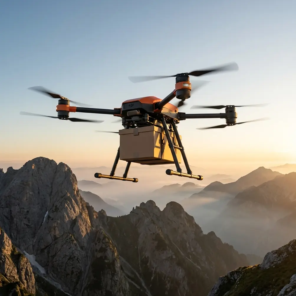
The FlyCart 30 gave us the right platform traits for the day: a heavy-duty logistics drone architecture, a dual-battery configuration that supports operational continuity and planning flexibility, and a platform built for structured route work rather than improvised hobby-style flying. In corridor environments, those traits matter more than flashy specs on paper. When the weather shifts, resilience is not a talking point. It is what determines whether you finish the route with clean data.
The biggest early mistake: treating “pro-looking” footage as the target
I have seen teams mount a mission camera, dial settings toward the visual style they think looks advanced, and accidentally reduce the value of the whole flight. The photography reference makes the problem very clear: using the maximum aperture can lower your margin for error. The article specifically recommends that beginners start in the f5.6 to f8 range because that improves sharpness and tolerance while retaining some background separation.
For highway scouting, that principle is operationally significant.
When wind is moving the aircraft, the subject is rarely a perfectly isolated object sitting on a static background. You are trying to read relationships: guardrail to shoulder, drainage to embankment, pavement edge to vegetation, access road to mainline, obstruction to right-of-way. If the visual approach strips out too much environmental context, the footage may look sleek but become weaker for analysis. A little more depth of field often gives operations teams what they actually need: confidence in what they are seeing.
In our case, we briefed the crew with a simple rule. Prioritize clarity over style. Preserve context over blur. Keep the corridor readable.
That meant resisting the instinct to push camera settings toward the most aggressive aesthetic profile. The photography article’s warning about missed focus is especially relevant from a drone. In ground portrait work, a soft eye is annoying. In aerial corridor assessment, soft focus can make the difference between confirming a minor shoulder washout and missing it.
Wind changed the mission halfway through
The first leg was manageable. Crosswinds were noticeable but consistent. We had built the route around known exposure points and battery planning, and the FlyCart 30 tracked predictably. This is where route optimization earns its keep. It is not just about efficiency in the abstract. In wind, route structure helps you decide what to capture first, what can wait, and what sections need a second look if conditions deteriorate.
About midway through the run, the weather shifted. The corridor moved from “workable with caution” to “actively changing.” Gust behavior became less uniform. We saw more turbulence near an elevated section and a transition zone where open ground fed wind into the highway edge.
That is the point where inexperienced teams often make two mistakes.
The first is to keep pressing as if the original plan still fits the conditions.
The second is to compensate visually rather than operationally. They zoom mentally into the image problem instead of stepping back to the mission problem.
With the FlyCart 30, the response was straightforward. Reassess route priority. Tighten the flight plan around the sections with the highest decision value. Use the platform’s stability and power reserve intelligently. And do not ask the camera to rescue bad operating choices.
The dual-battery setup mattered here because it gave us more than endurance. It gave us decision space. In a windy scouting mission, decision space is everything. You can choose to re-fly a short segment, hold enough reserve for a safer return profile, or reposition your coverage priorities without immediately compromising the rest of the sortie.
Why payload ratio matters even on a scouting job
People tend to hear “payload ratio” and think only about carrying capability. That is too narrow.
On a platform like the FlyCart 30, payload ratio affects how flexibly you can configure the aircraft for the mission without forcing tradeoffs that hurt stability, time on task, or data quality. Even when the mission is scouting rather than transport, that logic still applies. The more intelligently the aircraft handles mission equipment relative to its design envelope, the more confidence you have when the environment stops cooperating.
In our highway case, that showed up in practical ways. We needed reliable corridor observation, not a stripped-down setup that looked efficient until the wind picked up. A robust logistics platform earns its place by staying composed when the route is exposed and when the mission profile changes from smooth progression to selective verification.
That is one reason I prefer case studies over brochure language. A payload figure alone tells you very little. Payload ratio in context tells you whether the aircraft remains useful when real conditions intrude.
The winch system was not the headline, but it shaped the plan
The FlyCart 30’s winch system is usually discussed in delivery scenarios, but the operational significance reaches further. In highway work, one of the constant challenges is interacting safely with uneven access points, embankments, or roadside zones where a direct landing may be inconvenient or undesirable.
We did not build the mission around a dramatic use of the winch. What mattered was having it as part of the planning toolkit. A platform with a winch-capable workflow changes how you think about handoff points, equipment staging, and contingency support during corridor operations. That influences the route before takeoff. It also reduces pressure to force the aircraft into less suitable ground interactions just because that is the only method available.
This is a subtle point, but it matters. Good operations are often defined by the options you never need to use because their availability allows better decisions upstream.
BVLOS discipline starts long before the aircraft leaves the ground
Any conversation about BVLOS in corridor operations should stay grounded in legal approvals, company procedures, and site-specific compliance. But from an operational standpoint, the main lesson is simple: beyond visual line of sight work exposes weak planning faster than almost any other mission type.
The photography reference again offers a surprisingly useful analogy. It argues that beginners should not jump straight to the most demanding aperture choices before they can reliably control focus. The advice is to start where the margin for error is better, then adapt once the fundamentals are solid.
That is exactly how mature BVLOS culture should work around a platform like the FlyCart 30.
Do not build your process around the most ambitious version of the mission before your team has mastered route logic, subject prioritization, weather interpretation, and data discipline. Start with settings, procedures, and flight profiles that produce clear, repeatable results. Then expand complexity once the fundamentals are proven.
In our highway scouting run, that meant conservative visual capture settings, conservative segment prioritization, and conservative reserve thinking once the weather worsened. None of that felt glamorous. All of it paid off.
Emergency systems are not there to make teams reckless
The FlyCart 30’s emergency parachute belongs in the same category as the dual-battery system: essential, but easy to misunderstand. Safety systems should widen your margin, not justify pushing beyond it.
In windy highway environments, the presence of an emergency parachute matters because the route often crosses mixed terrain and infrastructure zones where consequence management cannot be an afterthought. That does not mean you lean on the system. It means you account for it as one layer in a larger risk framework that includes route design, environmental monitoring, aircraft configuration, and return thresholds.
The teams that get the most value from these systems are usually the least dramatic about them.
What the footage taught us
When we reviewed the scouting output, the strongest segments were not the most visually striking. They were the ones where the scene remained readable. You could track lane edge conditions and still understand the surrounding environment. You could assess roadway context instead of guessing what had been blurred out. The focus held where it needed to hold.
That result goes directly back to the photography lesson. The source article recommended f5.6 to f8 for beginners because it improves sharpness and tolerance while helping them practice focus and composition. For a windy aerial corridor mission, the equivalent mindset is to favor settings and procedures with a higher fault tolerance. If your subject and your environment both matter, build for both.
The weaker clips were the ones that drifted toward a style-first look. They isolated details but reduced interpretability. In highway scouting, that is not refinement. It is loss.
The human factor is still the real variable
The platform performed well. The weather changed mid-flight, and the aircraft handled the shift in a way that let us reframe the mission rather than abandon it outright. But the real lesson was not that the FlyCart 30 is somehow immune to wind or complexity. It is that a capable aircraft rewards disciplined operators.
That starts with the brief. What are we trying to learn from this route? Which segments have the highest operational value? What level of environmental context must remain visible in the imagery? How much battery reserve do we want if the corridor gets uglier on the return leg? Which contingencies are genuine and which are just technical wishful thinking?
If your team wants a shortcut, there isn’t one. There is only better judgment.
If you are evaluating whether the FlyCart 30 fits your own corridor or highway workflow, get into the practical details with someone who understands mission design, not just product sheets. I usually tell teams to start with route structure, weather assumptions, and capture requirements. The aircraft choice becomes clearer after that. If useful, you can message our operations desk here and compare notes against a real-world route profile.
The takeaway for FlyCart 30 operators
The most valuable insight from this mission came from an unlikely source: a beginner photography article warning that copied “pro tips” often fail in real use. That is exactly what happens in UAV operations when teams adopt surface-level habits without understanding the tradeoffs.
Two details from that reference deserve to stick:
- Opening the aperture to the maximum can cause focus errors and make the subject soft.
- Starting around f5.6 to f8 improves sharpness and margin for error.
Operationally, those are not just camera notes. They are a framework for how to think about FlyCart 30 missions in wind. Choose clarity over style. Choose tolerance over fragility. Keep enough environmental information in the frame to support decisions. Build route logic that survives a mid-flight weather change. Use dual-battery capacity and safety systems to create decision space, not false confidence.
That is what made this highway scouting mission work.
Not a trick. Not a slogan. Just the right aircraft, conservative discipline, and a refusal to confuse dramatic imagery with useful intelligence.
Ready for your own FlyCart 30? Contact our team for expert consultation.