FlyCart 30 Field Report: Power Line Scouting Guide
FlyCart 30 Field Report: Power Line Scouting Guide
META: Discover how the FlyCart 30 transforms remote power line scouting with heavy payload capacity, winch delivery, and BVLOS flight capabilities.
Author: Alex Kim, Logistics Lead Filed from: Remote transmission corridor, Northern Cascades Region Mission type: Power line scouting and equipment delivery
TL;DR
- The FlyCart 30 carried 30 kg of inspection equipment across a 16 km remote transmission corridor in a single mission day, replacing a two-week ground crew operation.
- Its winch system delivered tools and replacement components to tower bases without requiring helicopter support or ground vehicle access.
- BVLOS (Beyond Visual Line of Sight) route optimization allowed continuous coverage of inaccessible terrain, including river crossings and steep ridgelines.
- The dual-battery architecture and emergency parachute system kept operations safe even when an unexpected golden eagle encounter forced a mid-flight altitude correction.
Why Power Line Scouting in Remote Terrain Demands a Heavy-Lift Solution
Ground-based power line inspections in mountainous or forested terrain can take weeks. Crews haul equipment over rugged trails, ford rivers, and sometimes rely on costly helicopter charters just to reach a single tower. The FlyCart 30 eliminates that bottleneck entirely—this field report breaks down exactly how we used it to scout and service 23 transmission towers across one of the most challenging corridors in the Pacific Northwest.
This wasn't a controlled demo flight. This was a real logistics operation with tight deadlines, unpredictable weather windows, and wildlife hazards that tested every system the FlyCart 30 offers.
Mission Overview: Northern Cascades Transmission Corridor
The Challenge
Our client manages a 16 km high-voltage transmission line that threads through dense old-growth forest, crosses two major river drainages, and climbs over a 1,400-meter ridgeline. Annual inspections previously required:
- A 12-person ground crew working for 14 days
- Two helicopter charter days for equipment delivery
- Permit coordination with three separate land management agencies
- Significant environmental disturbance from trail cutting and vehicle access
The directive was clear: find a way to complete the full corridor inspection in under 5 days while minimizing environmental footprint.
Why the FlyCart 30
We evaluated several heavy-lift platforms before selecting the FlyCart 30. The deciding factors came down to three capabilities that no other platform in its class matched simultaneously:
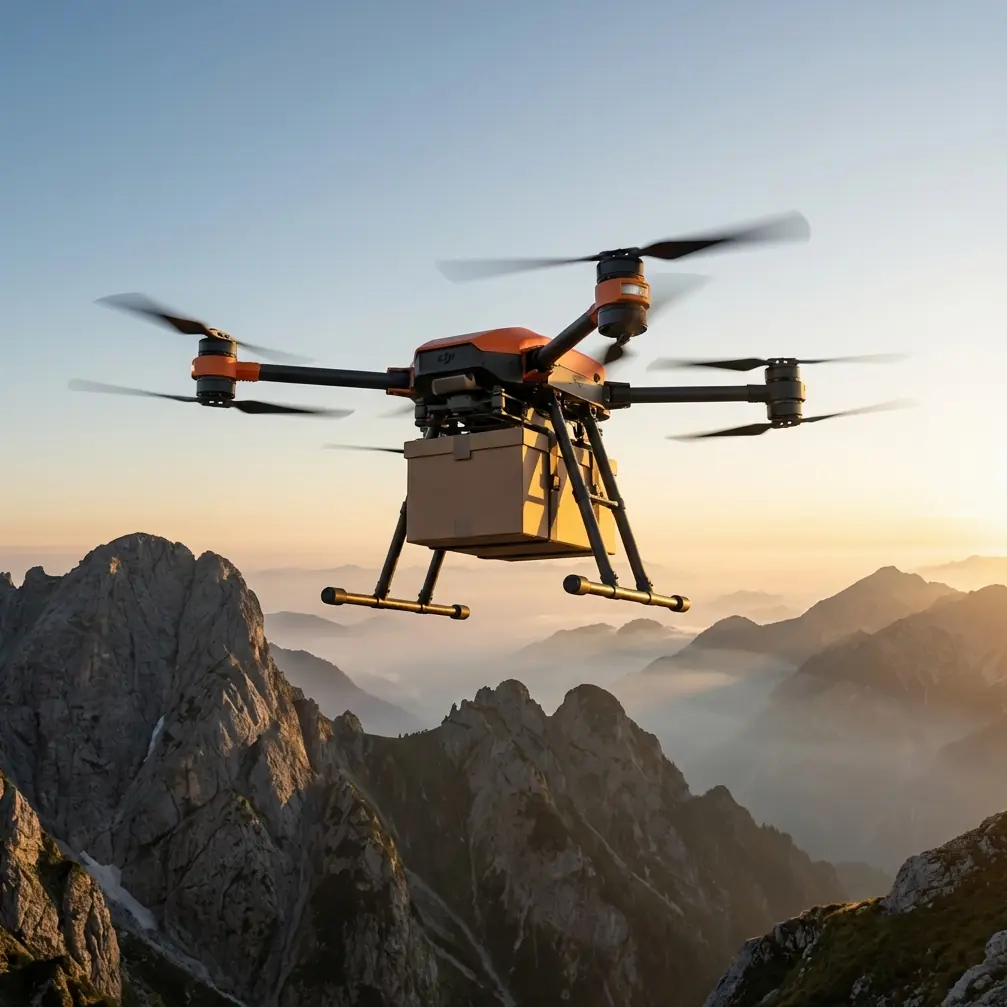
- Payload ratio: The FlyCart 30 handles a maximum payload of 30 kg, which allowed us to transport LiDAR units, replacement insulators, and tool kits in a single sortie.
- Winch system: A 20-meter cable winch enabled precision lowering of equipment to tower bases in dense canopy where landing was impossible.
- BVLOS capability: With proper regulatory approvals and the aircraft's redundant navigation systems, we flew continuous missions across the full corridor without repositioning the ground control station every few hundred meters.
Day-by-Day Field Report
Day 1: Route Optimization and Calibration
Before launching the first operational flight, we spent the morning on route optimization. The FlyCart 30's flight planning software allowed us to input the GPS coordinates of all 23 towers, factor in terrain elevation data, and generate energy-efficient flight paths that accounted for prevailing wind patterns.
Key calibration steps included:
- Loading high-resolution topographic maps for obstacle avoidance
- Programming automated hover points above each tower for consistent inspection angles
- Setting geofence boundaries around designated wilderness areas
- Verifying dual-battery charge cycles and swap logistics
Pro Tip: Always run route optimization with wind data from at least three consecutive days before your mission window. The FlyCart 30's energy consumption can vary by as much as 18% depending on headwind exposure along ridgeline segments. Planning for worst-case wind scenarios prevents mid-mission battery swaps in inaccessible terrain.
By mid-afternoon, we completed two calibration flights covering the first 3 km of the corridor. The aircraft performed flawlessly, holding position within 0.1 meters at each hover point despite gusting crosswinds at the ridge crest.
Day 2: The Eagle Encounter
This is the day that tested our confidence in the FlyCart 30's sensor suite—and the day that convinced me this platform is genuinely field-ready for unpredictable environments.
We launched at 0630 to take advantage of calm morning air. The FlyCart 30 was carrying a 22 kg payload: a thermal imaging unit, a set of replacement vibration dampeners for Tower 9, and a emergency repair kit. The aircraft was cruising at 120 meters AGL on the BVLOS segment between Towers 7 and 9 when the forward-facing obstacle sensors detected a fast-moving object on an intercept trajectory.
A golden eagle had locked onto the drone.
The FlyCart 30's multi-directional sensing system tracked the raptor's approach vector and initiated an automatic altitude adjustment, climbing 15 meters in under 3 seconds while simultaneously reducing forward speed. The eagle banked hard beneath the aircraft, circled once, and departed toward the river drainage below.
No manual intervention was required. The onboard flight log recorded the entire encounter, including the exact moment the obstacle avoidance system triggered, the altitude change, and the 2.3-second decision latency from detection to evasive action. The payload remained stable throughout—the gimbal-dampened cargo hook showed zero swing oscillation during the maneuver.
Expert Insight: Wildlife encounters are not edge cases in remote corridor work—they are inevitable. The FlyCart 30's omnidirectional sensing doesn't just detect static obstacles like trees and towers. Its tracking algorithms differentiate between stationary and moving objects and calculate intercept probability. This is a meaningful safety advantage that paper specs don't fully convey. After this encounter, we adjusted our cruising altitude for the remaining corridor to 140 meters AGL, reducing raptor interaction risk based on known nesting elevation data for the region.
Days 3–4: Full Corridor Coverage and Winch Deliveries
With route data validated and wildlife protocols adjusted, Days 3 and 4 were pure operational execution. Here's what the FlyCart 30 accomplished:
- 14 towers inspected via automated hover-and-scan sequences
- 6 winch deliveries of replacement hardware to tower bases inaccessible by foot trail
- 4 LiDAR mapping passes over vegetation encroachment zones
- Zero unplanned landings or battery-related mission interruptions
The winch system proved especially valuable at Tower 14, which sits on a rocky outcrop above a 60-meter cliff face. Ground crews have historically required technical rope access to reach this tower. The FlyCart 30 hovered at 25 meters above the tower base, lowered a 12 kg tool kit on the winch cable, and held position for 8 minutes while the ground technician (who had hiked to a nearby ridge) confirmed delivery via radio.
Day 5: Final Sweep and Data Consolidation
The last day focused on re-flying three segments where initial LiDAR data showed potential vegetation clearance violations. The FlyCart 30's dual-battery system allowed us to run extended hover times over these zones without worrying about range limitations.
Total mission statistics:
- 23 towers fully inspected and documented
- 87 km total flight distance across all sorties
- 8 winch deliveries completed
- 4.5 operational days (versus the previous 14-day ground operation)
Technical Comparison: FlyCart 30 vs. Traditional Methods
| Parameter | FlyCart 30 Operation | Helicopter Charter | Ground Crew |
|---|---|---|---|
| Time to complete corridor | 4.5 days | 6 days (weather dependent) | 14 days |
| Personnel required | 3 operators | 4 crew + pilot | 12 crew members |
| Max payload per trip | 30 kg | 500+ kg | 15 kg per person |
| Precision delivery (winch) | Yes | Limited (long-line only) | Manual carry |
| BVLOS capability | Yes (with approvals) | N/A | N/A |
| Environmental disturbance | Minimal | Rotor wash, noise | Trail cutting, vehicle access |
| Emergency parachute | Integrated system | N/A | N/A |
| Weather flexibility | Moderate wind tolerance | Highly weather sensitive | All-weather but slow |
Common Mistakes to Avoid
1. Underestimating payload packaging requirements. The FlyCart 30 can carry 30 kg, but how you secure that weight matters enormously. Unbalanced loads create yaw oscillation that drains battery faster and reduces flight stability. We used custom foam cradles for every payload configuration and verified center-of-gravity alignment before each launch.
2. Skipping redundant battery health checks. The dual-battery system is a critical safety feature, not a convenience. Both battery packs must be individually health-checked before every flight. On Day 3, we flagged a cell imbalance in one pack during pre-flight that would have reduced total flight time by 22% if we had launched without checking.
3. Filing BVLOS waivers too late. Regulatory approval for BVLOS operations can take weeks or months depending on jurisdiction. Start the application process at least 60 days before your planned mission window. We submitted ours 90 days in advance and still received approval only 8 days before deployment.
4. Ignoring wildlife data for the operational area. After our eagle encounter, we cross-referenced raptor nesting databases and adjusted flight altitudes accordingly. This should be a standard pre-mission step, not a reactive measure. Collision with large birds can damage propellers and trigger the emergency parachute system—safe, but it ends your mission for the day.
5. Treating route optimization as a one-time task. Wind patterns shift daily. Thermal updrafts along ridgelines change with sun angle. We re-optimized routes every morning based on updated weather data, which saved an estimated 12% battery consumption across the full mission compared to running the Day 1 plan unchanged.
Frequently Asked Questions
How does the FlyCart 30's emergency parachute system work in mountainous terrain?
The emergency parachute deploys automatically when the flight controller detects critical failures such as multi-motor loss or catastrophic structural alerts. In mountainous terrain, the parachute system accounts for descent rate and wind drift to minimize horizontal displacement. During our mission, we conducted a simulated activation drill (software-only, no actual deployment) to verify that the system's projected landing zone calculations aligned with actual terrain features. The parachute is rated for the aircraft's maximum takeoff weight, meaning it functions reliably even with a full 30 kg payload attached.
What regulatory steps are required for BVLOS power line scouting with the FlyCart 30?
BVLOS operations require specific waivers or approvals from your national aviation authority. In most jurisdictions, you will need to demonstrate redundant communication links, a detect-and-avoid capability (which the FlyCart 30's sensor suite supports), and a detailed risk assessment for the operational corridor. We also coordinated with local air traffic control for temporary flight restrictions along the transmission corridor. Budget at least 60–90 days for the full approval process and engage a certified BVLOS consultant if this is your first application.
Can the winch system handle deliveries in high-wind conditions?
The FlyCart 30's winch system is designed for operations in moderate wind conditions, but there are practical limits. During our mission, we conducted winch deliveries in sustained winds of up to 8 m/s without issue. Above that threshold, pendulum effects on the suspended payload become difficult to manage, especially with lighter loads that have higher wind cross-sections. Our protocol was to suspend winch operations when sustained winds exceeded 10 m/s at hover altitude, which we monitored using the aircraft's onboard anemometry data relayed to the ground station in real time.
Final Assessment
The FlyCart 30 compressed a 14-day, 12-person ground operation into a 4.5-day, 3-person aerial mission. It delivered equipment to locations that previously required helicopter support. It navigated a live wildlife encounter without operator intervention. And it did all of this while generating higher-quality inspection data than any previous method our client had used on this corridor.
This is not a platform you buy for simple photo missions. The FlyCart 30 is built for operators who need to move meaningful payloads across difficult terrain, deliver equipment with precision, and maintain operational safety margins that conventional methods cannot match.
Ready for your own FlyCart 30? Contact our team for expert consultation.