FlyCart 30 for Remote Wildlife Scouting: What Railway Drone
FlyCart 30 for Remote Wildlife Scouting: What Railway Drone Enforcement Teaches Civilian Operators
META: A field-grounded FlyCart 30 case study for remote wildlife scouting, covering route discipline, EMI handling, training, BVLOS planning, and why railway drone enforcement matters for compliant operations.
I spend a lot of time thinking about drones in places where the aircraft is only half the story. The other half is everything around it: who is flying, where they are flying, why they are there, and what sits just beyond the edge of the mission map. That broader picture matters even more when the platform is something like the FlyCart 30, a heavy-lift aircraft that attracts attention because of what it can do, but also because of what can go wrong when it is used casually.
A recent development from China’s railway policing system is a good example of why this matters. Railway police, working with local public security and market supervision departments, have been carrying out inspections and corrective actions focused on unauthorized drone flights near rail corridors, along with kite incursions. They have not limited their attention to the airspace itself. They have also gone into drone sales companies and training bases along railway lines to investigate sales scope, buyer groups, and the main uses of those aircraft. On top of that, they are maintaining close contact with local photography associations and train enthusiasts to understand flight and shooting activities that could affect railway safety.
That is not just a transport safety story. For anyone considering the FlyCart 30 for remote wildlife scouting, it is a sharp reminder that serious drone operations are judged as much by intent, planning, and operating culture as by hardware.
Why this matters specifically for the FlyCart 30
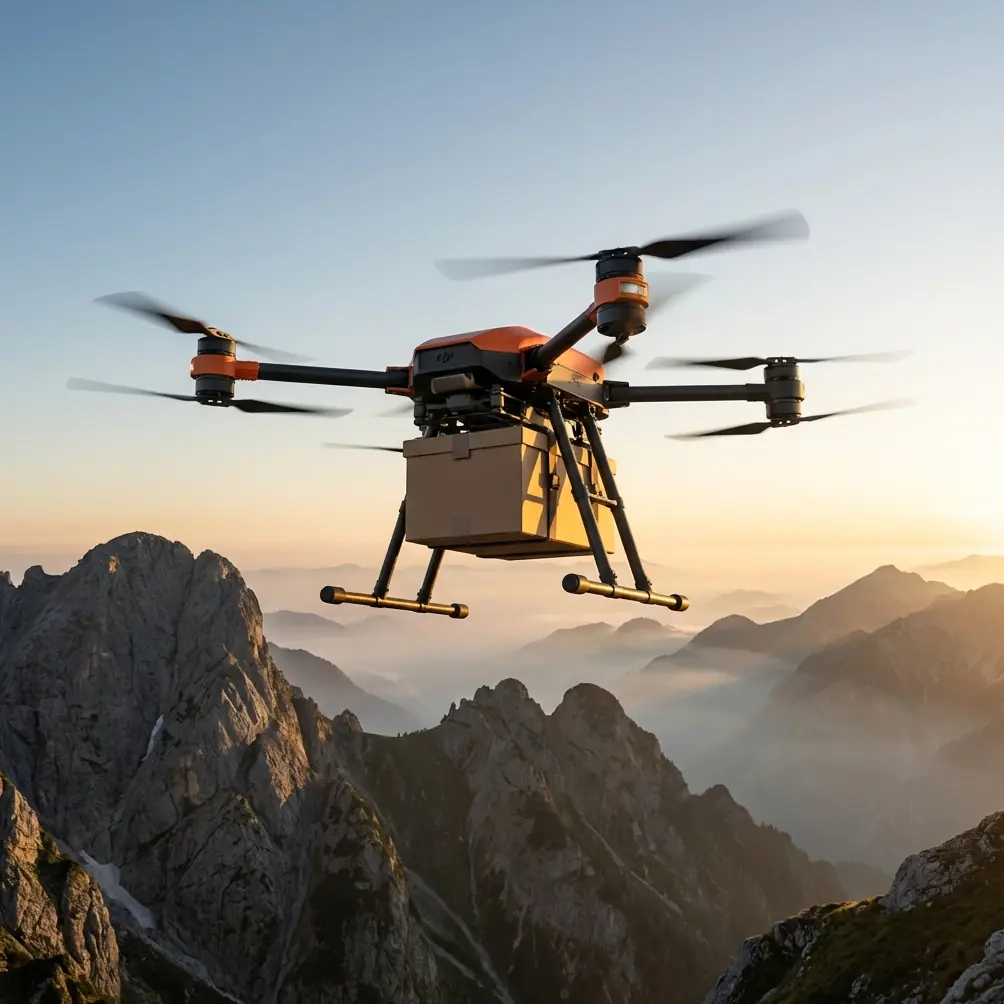
The FlyCart 30 is often discussed in logistics terms, and for good reason. Its payload ratio, winch system, dual-battery architecture, and safety stack make it well suited to moving equipment into rough terrain. But in wildlife scouting, those same features shift its role. Instead of being simply a transport drone, it becomes a field support platform.
That distinction matters.
In remote conservation work, you may use the aircraft to carry camera traps, acoustic sensors, lightweight feed-safe monitoring tools, batteries for field stations, or emergency supplies for a survey team operating beyond road access. The aircraft may not be collecting imagery in every sortie, but it is still part of a data-driven operation. And because the FlyCart 30 can support missions farther from easy infrastructure, it pushes teams toward more advanced route planning, more demanding communications conditions, and greater scrutiny around operating near protected zones, transport corridors, and scattered communities.
The railway enforcement case underscores something many operators prefer to ignore: authorities are increasingly interested in the full chain behind a flight. Not just the aircraft in the sky, but the seller, the trainer, the user profile, and the operational purpose. For a FlyCart 30 operator in wildlife work, that means your paperwork, training discipline, and mission justification are not secondary details. They are part of the mission.
A field scenario: remote wildlife scouting with a heavy-lift platform
Let’s make this concrete.
Imagine a conservation team tasked with scouting a remote valley used by migratory mammals and nesting raptors. Ground access is poor. One side of the valley is cut by steep rock faces, the other by scrub and unstable tracks. There is also a rail corridor several kilometers away, not inside the work area but close enough that an undisciplined route or a drifting contingency path could create a problem.
A small multirotor can handle quick visual surveys, but the operation needs more than that. The team has to place passive sensors, move spare power packs to a ridge station, and support a three-day observation window without repeated human trekking through sensitive habitat. This is where the FlyCart 30 starts making sense.
Its winch system is not just a convenience here. It changes how the team interacts with the environment. Instead of landing repeatedly on uneven or ecologically sensitive ground, the aircraft can hover and lower payloads with precision. Operationally, that reduces rotor wash impact, minimizes disturbance around nesting or resting zones, and lowers the chance of a rough touchdown damaging gear or vegetation. For wildlife work, that is a practical advantage, not a marketing bullet.
The dual-battery setup matters for a different reason. In remote scouting, the cost of a mission interruption is not merely time. It can mean a missed migration window, a lost weather gap, or a failed deployment sequence for multiple sensor nodes. A dual-battery architecture supports continuity and redundancy thinking. It does not eliminate risk, but it gives logistics leads a better planning base for sortie sequencing, reserve margins, and safe return criteria.
What the railway crackdown reveals about operator maturity
The most revealing part of the railway enforcement news is not that authorities are cracking down on “black flights.” Everyone expects that. The real signal is that they are investigating drone sales companies and training bases to understand who is buying, what they are buying for, and how those aircraft are likely to be used.
That has direct operational significance for FlyCart 30 users.
A wildlife scouting team cannot approach a heavy-lift drone like a hobby purchase with upgraded batteries. If local authorities are examining buyer groups and primary use cases, then your organization should be able to clearly articulate all three of these:
- Why the platform is necessary.
- What the operating area requires.
- How the mission avoids interference with public infrastructure and local activity.
This is particularly relevant in regions where rail corridors cut through rural or mountainous terrain. Conservation areas, camera vantage points, and scenic ridgelines often overlap with places that also attract train photographers and aviation hobbyists. The source report specifically mentions coordination with photography associations and train enthusiasts. That detail matters because it shows authorities recognize that not all risky drone activity comes from malicious intent. Often it comes from enthusiastic, image-driven flying near sensitive infrastructure.
For wildlife teams, the lesson is simple: don’t assume your good intentions make your operation legible to outsiders. If your route planning, observer positioning, and launch site selection look ambiguous, you can be mistaken for the same kind of traffic authorities are already watching.
Handling electromagnetic interference in the real world
The context around FlyCart 30 often mentions BVLOS and route optimization, but in remote scouting there is a quieter issue that can become decisive: electromagnetic interference.
I have seen this in mixed terrain where a route appears straightforward on the map but becomes messy in the air because of power lines, telecom relays on ridges, metal infrastructure, or signal reflections near cut rock faces. In one valley deployment, a command link became unstable only on the outbound leg when the aircraft passed a shoulder that lined up with a rail-side communications installation in the distance. The problem was not constant; it was geometry-dependent.
The fix was not dramatic. We adjusted the ground antenna orientation, moved the control position several meters to improve line-of-sight, and redefined the route to avoid a shallow-angle segment that exposed the aircraft to reflected noise. That one change cleaned up telemetry consistency and reduced unnecessary hovering.
This is where route optimization stops being software jargon and becomes fieldcraft.
For FlyCart 30 wildlife missions, antenna adjustment should be treated as a normal pre-sortie variable, not a last-minute reaction. If the aircraft is supporting BVLOS-style operations within the permitted framework of your jurisdiction and mission approvals, then the control link environment deserves the same attention as payload weight and battery reserve. In rough country, a minor improvement in antenna alignment can make the difference between smooth progression and repeated pauses that waste energy and increase disturbance.
Payload ratio is not just about lift
Heavy-lift drones are often evaluated by how much they can carry. That is too narrow.
In wildlife scouting, payload ratio should be understood in terms of mission composition. A drone that can lift more than you immediately need gives you options: a camera trap plus weather shielding, a sensor package plus spare battery, or a field medical pouch bundled with monitoring gear. But every extra kilogram changes endurance, route flexibility, descent profile, and acoustic footprint.
The best FlyCart 30 operations I have seen are conservative, not maximalist. Teams use payload headroom strategically. They avoid loading to the edge unless the mission genuinely requires it. That approach pays off when conditions change fast, especially in mountain weather or uneven thermal activity over cliffs and scrubland.
It also aligns with the spirit of the railway enforcement trend. If authorities are examining main uses and user groups, then disciplined loading and documented mission design become part of your operational credibility. A team that can explain exactly why a given payload was selected, how it affects route safety, and why a winch drop was chosen over a landing will be viewed very differently from one that simply says the aircraft is capable of it.
Emergency systems are only useful if they shape planning
The mention of emergency parachute in FlyCart 30 discussions is often reduced to a checklist item. That undersells it.
An emergency parachute is not permission to fly aggressively over unsuitable areas. Its real value is in how it influences your no-go map and contingency logic. In wildlife scouting, that means identifying where a degraded flight can safely terminate without endangering rail assets, roads, livestock, field teams, or sensitive habitat.
This circles back to the railway case. When public authorities target unauthorized flights near rail lines, they are responding to the fact that even small aircraft can create outsized consequences around transport infrastructure. A larger commercial platform raises that bar. If your mission area is anywhere near rail-adjacent geography, your contingency planning should explicitly account for drift, descent paths, and recovery zones. “We weren’t planning to fly over the corridor” is not enough.
Training bases, sales channels, and why procurement now matters more
Another useful signal from the source report is the attention being paid to training bases and sales companies. That tells us procurement and training records are becoming operationally relevant.
For organizations adopting the FlyCart 30, the aircraft should enter service through a documented process that ties together mission need, staff competency, maintenance readiness, and local airspace awareness. That is especially true for wildlife programs, where teams may include ecologists, field technicians, and GIS personnel who are excellent at their core work but may not have deep experience with heavy-lift aviation procedures.
A proper training pathway should cover more than airframe operation. It should include:
- infrastructure sensitivity awareness, especially around railways and utility corridors
- low-disturbance launch and recovery methods in habitat zones
- winch deployment discipline
- link management in EMI-prone terrain
- weather-driven route revision
- emergency decision thresholds with payload onboard
If you are building that workflow now and need to compare setup options with your field requirements, one practical starting point is to message a FlyCart 30 deployment specialist.
The overlooked issue: photographers, enthusiasts, and shared airspace culture
The source also mentions outreach to photography associations and train enthusiasts. That may seem peripheral to a wildlife article, but I think it is one of the most telling details.
Remote wildlife scouting often happens in visually striking places. Those same landscapes attract photographers, recreational pilots, and hobby groups. Not all interference comes from formal airspace conflicts. Sometimes it comes from parallel use of the same ridgeline, overlook, or access road by people with entirely different objectives.
For FlyCart 30 teams, this means stakeholder awareness should extend beyond regulators and land managers. If a launch area is near a scenic rail crossing, a lookout, or a known enthusiast gathering point, your team should anticipate curiosity, unplanned foot traffic, and the possibility that another drone may appear without notice. That is not paranoia. It is normal operating reality.
The better approach is proactive separation: choose quieter launch windows, shift staging zones away from obvious attraction points, and avoid routes that could be mistaken for recreational filming patterns. A professional operation should look different from casual flying even to a bystander.
The FlyCart 30 takeaway for wildlife operators
The strongest lesson from the railway enforcement story is not “be careful near trains.” It is broader than that.
Authorities are paying attention to ecosystems of drone use. They want to know who is selling, who is training, who is buying, and what kinds of activities are happening near sensitive infrastructure. For FlyCart 30 users in wildlife scouting, that reality raises the standard. The aircraft’s capability is only part of the equation. Your mission design, route optimization, BVLOS discipline where permitted, antenna management in EMI-prone terrain, payload logic, and contingency planning all need to show that the operation belongs in the commercial-professional category.
That is exactly where the FlyCart 30 can shine.
Used well, it allows conservation and field logistics teams to reduce ground disturbance, move equipment into hard-to-reach zones, support longer observation windows, and operate with more precision than a carry-it-by-hand model ever could. But the platform rewards mature operators. It asks for planning that respects not just the mission area, but the surrounding human infrastructure and user community.
For wildlife teams working remote, that is the real standard now. Not whether the drone can reach the ridge. Whether the entire operation holds up when someone asks why it needed to be there, how it was flown, and what safeguards were built around it.
Ready for your own FlyCart 30? Contact our team for expert consultation.