How We Used the FlyCart 30 to Survey an Urban Construction S
How We Used the FlyCart 30 to Survey an Urban Construction Site When the Weather Turned Mid-Flight
META: A real-world FlyCart 30 case study for urban construction site surveying, covering route planning, payload tradeoffs, winch use, dual-battery resilience, and how changing weather affects field operations.
I lead logistics planning for drone-supported site operations, and one of the more revealing FlyCart 30 deployments I’ve been involved in did not begin as a showcase. It began as a problem.
The site was dense, vertical, noisy, and very much alive. Tower cranes were moving, delivery trucks were stacking up at the entrance, and a utility contractor had changed staging positions overnight without telling anyone outside their own team. The surveying brief looked straightforward on paper: capture status across multiple elevation zones, confirm material placement on upper sections, and move a lightweight sensor package to a point that was awkward to reach without interrupting work below.
Urban construction sites have a way of punishing assumptions. That day, the weather did too.
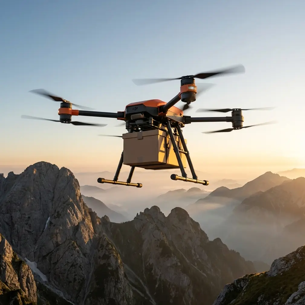
This is where the FlyCart 30 became more interesting than its “cargo drone” label suggests.
Why the FC30 made sense for a surveying job
People often frame the FlyCart 30 around lifting and delivery. That misses part of the picture. On active construction sites, surveying is not only about image capture. It is also about moving the right tools, at the right time, into positions that let the survey team actually finish the job without slowing down everyone else.
That is where payload ratio matters. If your aircraft can carry a meaningful inspection or survey-related payload while still preserving stable flight characteristics and practical endurance, you gain options. You can fly a sensor package, drop a line, lower a compact instrument, or support a hybrid workflow where aerial transport and data collection happen in the same operational window. On a congested site, that flexibility is often more valuable than raw top speed.
The FlyCart 30 fit because we weren’t trying to force a pure mapping-aircraft workflow onto a site that didn’t behave like an open field. We needed route optimization around structures, vertical access without adding risk to crews below, and enough system redundancy to keep the operation disciplined when conditions drifted away from ideal.
Planning the mission like a logistics problem, not a photo outing
One detail from the reference material kept coming back to me while building the flight plan: hardware sets the upper limit. The source article was about phone photography, but the principle carries cleanly into professional drone work. It argued that ordinary phones often produce soft, gray-looking images, messy light handling, and weak distant detail because hardware and algorithms directly shape what is possible. It also singled out larger sensors and better optics as the first major reason flagship phones perform better.
That same operational truth applies on construction surveys. Field teams sometimes try to compensate for weak platforms with extra effort. More passes. More retakes. More manual checking. But if the core aircraft system, payload integration, and sensing package are not suited to the environment, technique only gets you so far.
On this site, we built the mission around system capability first.
We divided the operation into three tasks:
- Perimeter and elevation confirmation
- Upper-level material verification
- Targeted instrument delivery using the winch system
The winch mattered because there was no appetite for landing on a partially occupied upper deck. Landing zones were inconsistent, dust movement was unpredictable, and a direct touchdown would have forced a temporary hold on nearby work. Lowering a small survey-related payload by cable gave us precision without inserting the aircraft into a cluttered touchdown area.
That choice alone reduced site disruption.
The route optimization challenge in an urban build
Urban surveying is rarely about point A to point B. It is about point A to point B without crossing crane arcs, without dropping into radio-shadow pockets behind concrete cores, and without creating unnecessary hover time over active personnel zones.
We optimized the route in layers.
First, we built a horizontal corridor that avoided known obstruction lines. Then we added vertical gates, because on a high-rise-adjacent site the cleanest route in two dimensions can become the worst route once you account for suspended loads, facade protrusions, and temporary steel.
The FC30’s value here was not brute force. It was operational adaptability. A logistics drone used for surveying must accept that the shortest route is not always the safest or fastest route once all site constraints are counted. Route optimization in this setting means reducing decision pressure in the air. If the pilot has to improvise every turn, the mission is already late.
We also staged the flight so that the first leg gathered situational awareness rather than rushing straight into the placement task. Construction sites change by the hour. Morning assumptions expire by noon.
Mid-flight, the weather changed
About a third into the operation, the weather shifted in a way every field crew knows too well. Wind was not the issue at first. The bigger change was light quality and atmospheric texture. The air thickened, contrast flattened, and the visual scene became harder to read around the far side of the structure. Anyone who has worked with imaging systems has seen the result: surfaces lose crisp separation, distant details stop resolving cleanly, and visual confidence drops before the mission technically becomes impossible.
That brings me back to the phone-camera reference again, because it captured a useful truth in plain language. It described common imaging failures as blurry, gray, cluttered in light handling, and weak on distant subjects. It also said the gap in hardware and computational processing directly determines the ceiling of image quality. For a construction survey, that is not an abstract photography debate. It affects whether you can verify edge conditions, distinguish materials, and trust what you think you are seeing across a busy site.
When weather shifts mid-flight, your aircraft does not just need to stay airborne. It needs to preserve mission quality.
With the FC30, the practical response was to shorten the next observation leg, tighten our angle selection, and transition earlier to the controlled lowering portion of the operation. That is where having a platform designed for more than one mode of value really helped. We were not relying exclusively on long-range visual detail from a deteriorating atmospheric window. We could still complete the objective by repositioning the task and using the winch system to place what the crew needed exactly where they needed it.
That kind of flexibility saves missions.
Using the winch system without stopping the site
The winch system was the operational hinge point that day.
We needed to get a compact survey support payload onto an upper area where foot access would have taken longer and introduced avoidable coordination headaches. A conventional landing would have required a cleaner deck and a wider sterile zone. Lowering the payload from hover allowed the crew to receive it with far less interruption.
This is one of those details that sounds minor until you work a real jobsite. A drone that can lower rather than land changes how site managers think about access. It turns a flight from an intrusion into a service.
The cable deployment also gave us a buffer against the now less predictable wind texture around the structure. Instead of committing the whole aircraft into a tighter envelope, we held a more conservative position and let the payload bridge the last segment. That improved safety margins while keeping the timeline intact.
Dual-battery thinking is not just about endurance
People often hear “dual-battery” and think only in minutes. That is too narrow.
On an urban construction mission, dual-battery architecture matters because it supports decision quality. When conditions begin to drift, crews need room to choose the safer option rather than feeling squeezed into finishing a task before reserves disappear. Extra resilience changes pilot behavior. It slows the temptation to press. That matters.
During our mission, the weather shift did not trigger an emergency. It triggered a re-evaluation. We had enough system confidence to modify the sequence, complete the essential placement task, and keep margins for return without turning the flight into a race against depletion.
That is a subtle but very real distinction. Field operations go wrong less often when the aircraft gives the crew permission to be conservative.
Emergency systems matter even when you never use them
The same logic applies to an emergency parachute. On a dense urban site, nobody wants to think about contingencies, but professionals do anyway.
You do not include an emergency parachute in your planning because you expect failure. You include it because urban work leaves little tolerance for unmanaged outcomes. Between scaffolding, parked vehicles, temporary offices, and rotating contractors, the ground environment is too crowded to treat risk planning as paperwork.
In our case, the parachute remained exactly what you want it to be: unused. But its presence shaped the safety case from the start, particularly when discussing approvals with site management. Confidence is not built by bravado. It is built by layers.
BVLOS discussions need realism on urban sites
BVLOS is one of those terms that gets thrown around too casually. In urban construction contexts, the more honest conversation is whether your operation architecture is mature enough for controlled, scalable missions that may extend beyond simple line-of-sight habits in the future.
Even when working within a tighter observation framework, the FlyCart 30 pushes teams to think in BVLOS terms: route discipline, communication protocols, emergency planning, obstacle logic, and handoff-ready procedures. That mindset improves even routine flights.
On this job, the biggest benefit was not some headline-grabbing long-distance segment. It was procedural rigor. We flew as if ambiguity had a cost, because it does.
What this job taught the site team
By the end of the mission, the biggest change was not the dataset. It was the site team’s attitude toward what a cargo-oriented UAV can contribute to surveying.
They started the day expecting a drone to “take a look” and maybe save a few stairs. They ended it seeing a more useful pattern:
- Aerial survey support is strongest when aircraft capability, payload strategy, and site logistics are planned together.
- Route optimization in cities is less about speed than about reducing conflict with real-world obstacles and work rhythms.
- A winch system can do more than delivery. It can preserve access, avoid unnecessary landings, and keep operations moving.
- Dual-battery resilience and emergency parachute planning are not marketing bullet points on dense sites. They directly affect whether a crew can make measured decisions when conditions change.
That last point is worth sitting with. The weather did not become dramatic enough to stop the operation instantly. It became uncertain enough to punish any workflow built on narrow margins. That is exactly where well-chosen equipment earns its keep.
A note on image expectations and “good enough” hardware
The reference article about phone photography made a deceptively simple argument: many users blame themselves when the real limit is the device. It pointed to familiar symptoms, including blur, flat-looking imagery, confused light rendering, and poor distant detail. Then it argued that stepping up to flagship-level hardware is the easiest first move because bigger sensors and better lenses raise the baseline.
Construction teams make the same mistake with drones. They assume mediocre results are a training issue when, in many cases, they are seeing the ceiling of the platform or payload setup. Better process matters, of course. But hardware still defines the outer boundary.
That is why FlyCart 30 projects should not be judged only by lift charts or transport scenarios. On mixed-purpose site missions, the real question is whether the aircraft lets you adapt when visual conditions worsen, access gets complicated, and the job shifts from observation to placement without warning.
On our urban site, it did.
If you’re evaluating the FC30 for construction surveying
Start with the site, not the spec sheet.
Ask where landings are actually realistic. Ask which tasks could be completed faster through controlled lowering rather than touch-and-go access. Ask how much decision space your battery architecture gives the crew when weather changes. Ask whether your routes are optimized for cranes, shadows, and evolving obstructions rather than idealized straight lines.
Then ask whether your current workflow is blaming pilots for limits that really belong to the system.
If you want to compare deployment ideas for your own project, you can message the operations desk here. Keep it practical: site layout, payload type, vertical access constraints, and your tolerance for downtime are the details that matter most.
The FlyCart 30 is at its best on jobs that refuse to stay simple. Urban construction surveying is exactly that kind of job. Not because the aircraft makes complexity disappear, but because it gives you more than one clean way to handle it when the plan meets the real site.
Ready for your own FlyCart 30? Contact our team for expert consultation.