FlyCart 30 for Mountain Field Surveys: What Actually
FlyCart 30 for Mountain Field Surveys: What Actually Matters in the Air
META: A technical review of DJI FlyCart 30 performance for surveying fields in mountain terrain, including flight altitude, payload ratio, winch use, dual-battery planning, route optimization, and safety systems.
Mountain field surveys expose the difference between a drone that merely flies and one that remains useful when terrain, wind, elevation change, and logistics all start competing at once. The FlyCart 30 sits in an unusual category because it was built around transport, but that does not limit its value in survey support work. In steep agricultural zones, especially where crews need to move sensors, markers, field kits, or sample payloads between terraces and ridge-access plots, the FC30 can become less of a cargo aircraft and more of a field-efficiency platform.
That shift in role is where most conversations get more interesting.
I work from a logistics mindset first, so when people ask whether the FlyCart 30 makes sense for surveying fields in mountain environments, I do not start with headline capacity alone. I start with altitude discipline, route design, turnaround speed, and how safely the aircraft can operate when the terrain below it is anything but uniform. If your mission involves repeated movement between valley launch points and elevated parcels, a poor flight profile can erase the advantages of the aircraft very quickly.
There is also a useful lesson hiding in an unrelated aviation story. A recent report from CAAC-linked coverage described EDID signing with RoyalJet to design interiors for 3 Airbus ACJ320neo business jets, following earlier successful collaborations in 2013 and 2016. On the surface, that has nothing to do with the FlyCart 30. Yet operationally, it says something relevant: the best platforms are rarely defined by raw hardware alone. They are defined by how well the system is adapted to the user’s environment and purpose. In that case, the design direction specifically incorporates Emirati cultural elements, which signals that real-world utility often comes from contextual fit, not generic specification chasing.
The same is true for mountain survey operations with the FC30. A good setup is not “maximum everything.” It is the right configuration for the field, the slope profile, and the handoff points your team actually uses.
Why the FlyCart 30 fits mountain field survey support
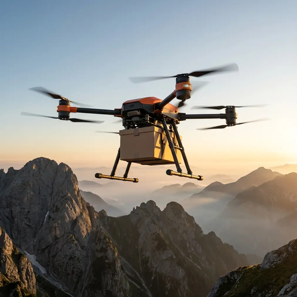
The FlyCart 30 is usually discussed as a delivery platform, but in mountain agriculture it can solve a narrower and more practical problem: reducing the human cost of moving survey resources over broken ground. That includes batteries, RTK equipment, lightweight field instruments, plant sampling kits, boundary markers, radios, emergency supplies, and temporary comms hardware. In some projects, the drone is not carrying the core imaging sensor itself. It is carrying the things that keep the survey moving.
This matters because mountain surveys are rarely linear. One crew may be working a terrace edge while another checks drainage or crop health patterns along a higher contour. Foot access burns time. Vehicle access may not exist. If the FC30 can handle repeated short-hop logistics with a stable workflow, the survey window expands without expanding fatigue.
That is where payload ratio becomes more meaningful than payload in isolation.
Payload ratio is the number that changes your planning
A mountain survey mission is not improved simply by loading the aircraft heavily. In fact, the wrong load profile often makes the aircraft less useful because the route becomes too short, the power margin shrinks, and your options disappear if the wind shifts at the ridge.
For this kind of work, the better metric is payload ratio: how much useful weight you carry relative to what the mission demands over that terrain, at that elevation, in those conditions. A small but well-selected load often outperforms a maximized one.
For example, if the FC30 is supporting field crews across staggered mountain plots, I prefer building mission packages around “single-action drops” rather than bulk transport. One battery set to one ridge team. One marked survey kit to one terrace line. One replacement instrument to one checkpoint. That keeps the aircraft responsive and preserves a stronger reserve margin for climb, diversion, or return.
On paper, maximizing the cargo bay sounds efficient. In the field, a balanced payload ratio usually wins because it protects time, not just lift.
The winch system is more than a convenience
In mountain agriculture, landing zones are often the weakest link. Terraces may be narrow. Soil can be soft or uneven. Crop rows can create rotor-clearance issues. Slopes distort depth judgment and increase the chance of a rushed touchdown.
That is why the FC30’s winch system deserves more attention in survey workflows.
The winch lets the aircraft avoid committing to a surface approach where terrain quality is uncertain. Instead of searching for a marginal landing spot near the receiving crew, the pilot can hold a safer hover position and lower equipment precisely. Operationally, that changes several things at once:
- It reduces rotor wash impact on loose soil, seedlings, and crop canopies.
- It lowers the risk associated with sloped or obstructed landings.
- It shortens handoff time because the crew receives the item without requiring a full touchdown cycle.
- It improves repeatability when delivery points shift slightly along terraces or field boundaries.
For mountain field surveys, that kind of precision matters more than people expect. A transport drone that can complete a handoff without forcing a landing opens far more usable delivery points across a hillside.
The best flight altitude is rarely the one new operators choose
Here is the practical altitude insight I give most often: when surveying fields in mountain terrain with the FC30 in a support role, avoid hugging the slope too closely unless the route absolutely requires it.
A lot of operators intuitively try to fly low along terrain because it feels efficient and visually controlled. In reality, for mountain routes this can create more turbulence exposure, more obstacle management, and more constant throttle correction. It also increases the risk of losing clean margin around trees, poles, line crossings, and irregular terrace edges.
A better approach is usually to maintain a moderate, consistent clearance above the highest local terrain along the route segment, rather than continuously tracing every contour. In practical terms, many teams find their most stable support flights occur when they stay high enough to clear localized rises and vegetation comfortably, but not so high that they absorb unnecessary wind from exposed ridge layers.
That “sweet spot” varies by valley shape and crop zone, but the principle is steady: choose an altitude that minimizes terrain-chasing. In mountain fields, smoothness often beats closeness.
If I were setting a starting profile, I would establish a conservative route above the dominant obstacle band first, then refine downward only if repeated observation confirms stable air and clear margins. The FC30 is most useful when it behaves predictably. Constant micro-adjustment is the enemy of productive survey support.
Route optimization in mountains is not just about distance
On flat ground, route optimization often means shortest path. In mountain conditions, shortest path can be the least efficient choice.
What matters more is energy shape. A route that climbs once, cruises steadily, and descends cleanly may perform better than a shorter line that repeatedly crosses uneven terrain pockets. Likewise, a path that avoids wind-sheared saddles or turbulent cliff faces can save battery and reduce operational stress even if the map line is slightly longer.
For FC30 operations supporting field surveys, I recommend segmenting routes into three classes:
- Primary shuttle lanes between base and recurring crew positions
- Secondary contingency lanes for weather or obstacle changes
- Emergency return corridors with the simplest terrain profile possible
This is especially relevant if you intend to scale into BVLOS-capable workflows where regulations and local approvals allow. Even before true beyond visual line of sight operations are in play, planning like a BVLOS operator improves discipline. It forces you to think in corridors, terrain envelopes, communication consistency, and alternates rather than one-off improvisation.
That is one of the clearest differences between casual drone use and professional field logistics.
Dual-battery planning is an operational advantage, not a spec-sheet footnote
In mountain work, batteries are never just about endurance. They are about decision quality.
A dual-battery architecture matters because terrain creates fewer forgiving moments. If one side of the route is a clear valley and the other is a rising wall of farmland, woodland, or rock, your reserve margin has to mean something. You do not want the aircraft spending the final portion of the flight in a narrow band where every percentage point forces a compromise.
The dual-battery setup supports continuity and redundancy in a way that makes practical sense for survey logistics. It gives operators more confidence in repeated shuttle cycles and can reduce the disruption caused by battery swaps within a fast-moving field team. More importantly, it changes planning behavior: crews are more likely to preserve meaningful return margin when they trust the system but do not overestimate it.
That distinction matters. Good mountain operators do not “use all the battery.” They protect options.
Emergency parachute: where safety becomes workflow
Many buyers view the emergency parachute as a last-resort feature and stop thinking there. In mountain survey support, it also affects route acceptance and crew confidence.
When operating over uneven terrain, agricultural infrastructure, and remote work teams, the presence of an emergency descent safeguard can support more disciplined risk management. It does not justify aggressive flying. It does the opposite. It gives your standard operating procedure a clearer backstop when evaluating whether a route is suitable, whether a payload is appropriate, and whether the weather window is acceptable.
The result is often better workflow, not bolder flying.
Survey crews in the field tend to adopt drone support more quickly when they trust the aircraft’s safety stack. That trust has to be earned by procedure, training, and system design together.
Field execution: a realistic mountain survey support cycle
A strong FC30 mountain workflow often looks like this:
The base team stages batteries, markers, field kits, and comms accessories at a lower access point. A crew moves to the upper terrace zone on foot. The FC30 launches with a modest payload ratio, follows a pre-validated route that clears the main obstacle line, then uses the winch system to lower the kit to a stable pickup area without landing. It returns on a separate corridor if the wind pattern has shifted around the ridge shoulder. The next sortie sends replacement batteries or collects a lightweight return load such as samples or used instrument packs.
That kind of cycle sounds simple, but once it repeats ten or fifteen times in a day, its value becomes obvious. The FC30 is no longer a novelty. It becomes the mechanism that keeps survey momentum intact.
If you are comparing route plans or need a second opinion on altitude selection for terraced mountain farms, I suggest sending your field profile through this direct project chat.
What the RoyalJet design story quietly teaches FC30 operators
That aviation design report I mentioned earlier is worth returning to for one reason. The EDID-RoyalJet agreement did not emerge from a first encounter. It followed prior successful work in 2013 and 2016, and now extends to three ACJ320neo aircraft with design choices tailored to the end user’s identity and operating context.
For FlyCart 30 operators, the lesson is straightforward: long-term performance comes from fit, repetition, and refinement. Not from one perfect flight.
In mountain field survey support, that means:
- refining altitude bands by valley and season,
- tuning payload ratio by route type,
- deciding when the winch is better than landing,
- establishing battery reserve rules that crews actually follow,
- and building routes around terrain behavior rather than map convenience.
That is how the FC30 becomes dependable.
Final take
The FlyCart 30 is at its best in mountain field surveys when it is treated as a precision logistics platform, not merely a heavy-lift drone. The operational wins come from disciplined altitude selection, careful payload ratio management, smart use of the winch system, and route optimization that respects terrain energy rather than just map distance. Add dual-battery planning and an emergency parachute into the safety framework, and the aircraft becomes far more practical for repetitive support missions in steep agricultural environments.
Used this way, the FC30 can remove some of the hardest friction points from mountain surveying: time lost to foot transport, crew fatigue, awkward handoffs, and unstable access conditions. That is where its value becomes tangible.
Ready for your own FlyCart 30? Contact our team for expert consultation.