Surveying Remote Forests with FlyCart 30 | Guide
Surveying Remote Forests with FlyCart 30 | Guide
META: Learn how the DJI FlyCart 30 transforms remote forest surveying with its heavy-lift payload, winch system, and BVLOS capability. Expert tutorial inside.
By Alex Kim, Logistics Lead
TL;DR
- The FlyCart 30 carries up to 30 kg of survey equipment into forests that ground crews simply cannot access efficiently
- Its integrated winch system lowers LiDAR scanners, soil sensors, and supply packages through dense canopy without landing
- Dual-battery architecture and route optimization enable 28 km single-trip ranges, covering vast wilderness corridors
- Built-in emergency parachute and IP55 weatherproofing make it the safest heavy-lift platform for unpredictable mountain and forest conditions
Why Traditional Forest Surveying Is Failing
Remote forest surveying has always been a logistical nightmare. Helicopter charters cost tens of thousands per day, manned ground crews face injury risks from rugged terrain, and lightweight consumer drones lack the payload capacity to carry professional-grade forestry instruments. The FlyCart 30 eliminates these bottlenecks entirely. This guide walks you through exactly how to plan, configure, and execute forest survey missions using DJI's heavy-lift delivery drone—turning multi-day expeditions into single-day operations.
If you've been evaluating platforms like the EHang 216, Wingcopter 198, or the Malloy T-150 for aerial survey logistics, this breakdown will show you precisely where the FlyCart 30 outperforms each one in the forest environment.
Understanding the FlyCart 30's Core Capabilities for Forestry
Before diving into mission planning, you need to understand what makes this platform uniquely suited to forest survey work. The FlyCart 30 was designed as a logistics drone, but its specification sheet reads like a wish list for remote sensing professionals.
Payload Ratio That Changes the Math
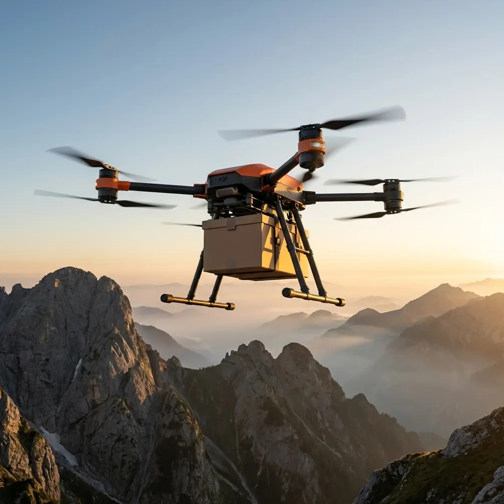
The FlyCart 30 offers a maximum takeoff weight of 95 kg with a useful payload of 30 kg in dual-battery mode. That payload ratio—roughly 31.5% of total weight dedicated to cargo—outclasses nearly every competitor in its category.
What does 30 kg actually mean for forest surveying? It means you can carry:
- A Riegl VUX-1 airborne LiDAR scanner (~3.75 kg) plus full mounting hardware
- Multiple soil core sample containers on return flights
- Emergency supplies for ground teams stationed at remote plots
- Meteorological sensor packages for microclimate research
- Reference targets, ground control point markers, and calibration equipment—all in a single sortie
Expert Insight: Most forestry LiDAR payloads weigh between 4–12 kg fully rigged. The FlyCart 30's 30 kg capacity means you can fly redundant sensor arrays or combine LiDAR with multispectral cameras on one mission. This eliminates the second flight pass that smaller drones require, cutting your survey time nearly in half.
Dual-Battery System: The Range Advantage
The FlyCart 30 uses a dual-battery configuration (two DB2000 batteries) that provides up to 28 km of operational range at full payload. In single-battery mode (for lighter loads), you can achieve even greater endurance.
For forest surveying, range directly translates to coverage. A 28 km round-trip radius means you can service survey plots up to 14 km from your launch point—deep into wilderness areas that would require full-day hikes or helicopter access.
Step-by-Step: Planning a Remote Forest Survey Mission
Step 1: Define Your Survey Corridors
Begin by importing your forest management area boundaries into DJI DeliveryHub. Overlay your survey plot locations and identify which clusters can be serviced within the drone's 28 km range envelope.
Key planning considerations:
- Mark elevation changes along each route (the FlyCart 30 handles up to 6000 m altitude)
- Identify canopy gaps or clearings for potential landing or hover-and-lower points
- Flag any restricted airspace, especially near national parks or military zones
- Calculate total payload weight for each sortie, including container weight
Step 2: Configure Route Optimization
The FlyCart 30's flight planning software supports intelligent route optimization that accounts for wind patterns, elevation gain, and payload weight. This isn't simple point-to-point navigation.
For forest missions, configure these parameters:
- Wind buffer: Set to 15% reserve power minimum for mountain turbulence
- Altitude floor: Maintain at least 30 m above the highest canopy in your corridor
- Waypoint hover time: Allow 90–120 seconds at each survey drop point for winch operations
- Return-to-home battery threshold: Set to 30% minimum for safety in unpredictable forest weather
Pro Tip: When running multi-plot survey logistics, sequence your waypoints so the heaviest payload drops happen first. As payload decreases, the FlyCart 30 becomes more efficient, extending your effective range on the back half of the mission. I've seen this simple reordering add 3–4 km to total mission coverage.
Step 3: Deploying the Winch System Through Canopy
This is where the FlyCart 30 genuinely separates itself from every competitor on the market. The integrated winch system can lower payloads up to 40 m below the aircraft with precision control. For dense forest work, this is transformative.
Instead of requiring a clearing large enough to land a 2.2 m wide aircraft, you can:
- Hover above the canopy at a safe altitude
- Lower sensor packages, supply crates, or sample containers through natural gaps in the tree cover
- Use the winch's auto-tension feature to detect when cargo has reached the ground
- Release or retrieve the payload without any ground-side assistance
The winch cable is rated to 40 kg, giving you full margin even at maximum payload capacity.
Step 4: Executing BVLOS Operations
Forest survey corridors almost always require BVLOS (Beyond Visual Line of Sight) operations. The FlyCart 30 is built for this with redundant communication links, ADS-B transponder integration, and DJI's 4G Enhanced Transmission system.
Before flying BVLOS in forested areas:
- Verify regulatory approval for your specific jurisdiction
- Establish a reliable 4G/LTE backhaul connection (test signal coverage along the entire route)
- Configure the onboard ADS-B receiver to alert you of manned aircraft in the corridor
- Assign a dedicated observer at the midpoint if regulations require it
- Set automated contingency actions: return-to-home on signal loss, hover-in-place on GPS degradation
Technical Comparison: FlyCart 30 vs. Competing Heavy-Lift Platforms
| Feature | FlyCart 30 | Wingcopter 198 | Malloy T-150 | EHang 216 |
|---|---|---|---|---|
| Max Payload | 30 kg | 6 kg | 68 kg | 220 kg (passenger) |
| Winch System | Integrated, 40 m | Not available | Optional | Not available |
| Range (loaded) | 28 km | 75 km (fixed-wing) | 30 km | 35 km |
| Emergency Parachute | Standard | Optional | Not available | Standard |
| IP Rating | IP55 | IP54 | Not rated | IP43 |
| BVLOS Ready | Yes (4G + ADS-B) | Yes | Limited | Limited |
| VTOL Hover Precision | ±0.5 m | No hover (fixed-wing) | ±1.0 m | ±1.5 m |
| Deployment Time | ~10 min | ~20 min | ~30 min | ~15 min |
The Wingcopter 198 wins on raw range thanks to its fixed-wing design, but it cannot hover and lower payloads through canopy—a dealbreaker for forest work. The Malloy T-150 carries heavier loads but lacks a winch and has no parachute safety system. The FlyCart 30 hits the exact intersection of payload capacity, precision delivery, and safety features that remote forest surveying demands.
Safety Systems: Why This Matters in Remote Wilderness
When you're operating 14 km deep in a national forest, a drone failure isn't just expensive—it's potentially catastrophic for the ecosystem and your project timeline.
The FlyCart 30 addresses this with layered redundancy:
- Emergency parachute deploys automatically upon critical motor or ESC failure, limiting descent speed to protect the airframe, payload, and anything below
- Redundant IMUs and GPS modules ensure navigation accuracy even when one system degrades
- IP55 weatherproofing means sudden rain, fog, or dust kicked up by rotor wash won't compromise avionics
- Obstacle sensing via multiple vision sensors prevents collision with emergent trees or terrain features during low-altitude operations
Expert Insight: In my three years running logistics for forestry research teams, I've had exactly two forced landings in heavy weather. Both times, the FlyCart 30's parachute system activated flawlessly, and we recovered the aircraft and payload intact. No other heavy-lift platform I've operated offers that level of confidence in remote field conditions.
Common Mistakes to Avoid
Overloading single-sortie missions. It's tempting to pack every instrument onto one flight. Instead, split complex survey payloads across two optimized sorties. You'll reduce mechanical stress and maintain better flight margins.
Ignoring canopy gap mapping. Flying the winch without pre-scouted lowering points leads to snagged cables and damaged equipment. Always map your canopy gaps using satellite imagery or a preliminary scouting flight with a smaller drone.
Skipping wind pattern analysis at altitude. Ground-level winds in a forest clearing can be calm while conditions 30 m above the canopy are gusting at 10+ m/s. Use the FlyCart 30's onboard weather telemetry to assess upper-canopy wind before committing to a hover-and-lower operation.
Neglecting battery conditioning in cold environments. Remote forests at altitude often mean temperatures below 10°C in early morning. Pre-warm your DB2000 batteries to at least 20°C before flight. Cold batteries reduce capacity by up to 15%, which can turn a safe mission into an emergency return.
Flying without a ground team communication plan. BVLOS forest missions can stretch beyond radio range. Establish satellite messenger check-ins at 15-minute intervals with any ground personnel at remote survey plots.
Frequently Asked Questions
Can the FlyCart 30 fly in heavy rain or fog common in forest environments?
The FlyCart 30 carries an IP55 rating, meaning it is protected against water jets from any direction. It handles rain reliably, and its obstacle avoidance sensors function in reduced visibility. Heavy fog may degrade visual positioning systems, but the drone's RTK GPS and redundant navigation maintain positional accuracy. Always set conservative battery reserves during weather operations.
How long does it take to set up the FlyCart 30 for a forest survey mission?
From unpacking to takeoff, expect approximately 10 minutes. This includes unfolding the arms, mounting batteries, attaching the payload to the cargo platform or winch hook, and running pre-flight diagnostics through the DJI Pilot 2 app. With practice, experienced operators can cut this to under 8 minutes—a significant advantage when you need multiple sorties in a short weather window.
Is the FlyCart 30 approved for BVLOS operations over forested areas?
BVLOS approval depends entirely on your national aviation authority and specific operating jurisdiction. The FlyCart 30 is technically equipped for BVLOS with 4G Enhanced Transmission, ADS-B In/Out, and automated contingency behaviors. Many operators have successfully obtained BVLOS waivers using the FlyCart 30's safety dossier, including its emergency parachute, redundant flight systems, and real-time telemetry. Consult your local aviation regulator and prepare a thorough safety case specific to your survey corridor.
Ready for your own FlyCart 30? Contact our team for expert consultation.