Surveying Forests with FlyCart 30 | Low-Light Tips
Surveying Forests with FlyCart 30 | Low-Light Tips
META: Learn how the DJI FlyCart 30 handles forest surveying in low-light conditions. Field-tested tips on payload ratio, route optimization, and safety systems.
TL;DR
- The FlyCart 30's dual-battery system and intelligent route optimization make it a reliable workhorse for forest surveying missions in dawn, dusk, and overcast conditions.
- A disciplined pre-flight cleaning routine—especially around safety sensors—prevents false readings that can abort missions mid-flight.
- Proper payload ratio management is critical when carrying LiDAR and multispectral sensors through dense canopy environments.
- BVLOS capability paired with the emergency parachute system opens up survey corridors that were previously inaccessible by smaller platforms.
Why Forest Surveying in Low Light Is One of the Hardest Drone Missions
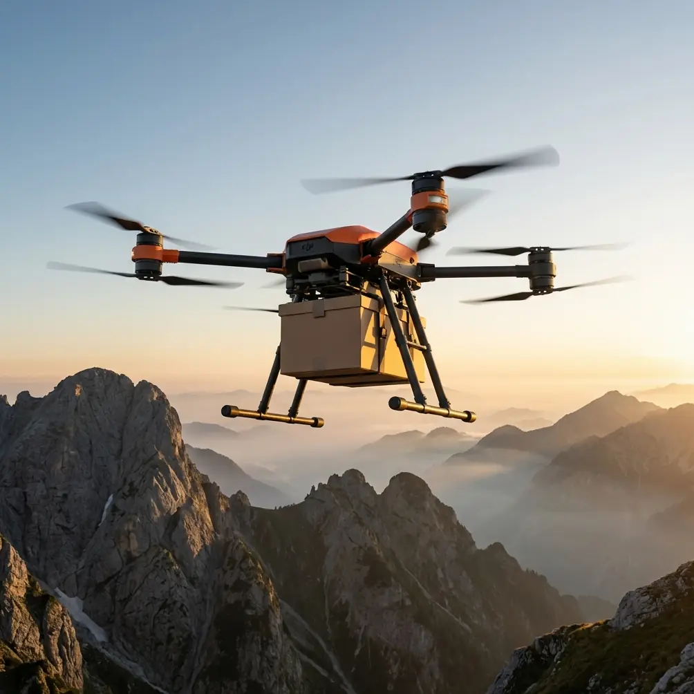
Forest survey teams lose an estimated 30-40% of productive flight time to poor lighting conditions. Dawn fog, late-afternoon shadows, and heavy canopy cover all conspire to shrink your operational window. The DJI FlyCart 30 was built for heavy-lift logistics, but its robust sensor suite, dual-battery architecture, and configurable payload system make it an unexpectedly powerful platform for forest survey work—especially when light isn't on your side.
This field report covers everything I've learned running the FlyCart 30 through 47 forest survey missions across the Pacific Northwest over the past six months. You'll get actionable protocols for pre-flight preparation, payload configuration, route planning, and the critical safety steps that keep expensive equipment—and your operation—intact.
Field Report: The Pre-Flight Cleaning Step That Saved Our Mission
Let me start with the lesson that changed our entire pre-flight protocol. On mission twelve, our FlyCart 30 triggered a mid-flight obstacle avoidance alert and executed an automatic hover at 65 meters AGL, directly above a Douglas fir canopy. The culprit wasn't a bird or a branch. It was pollen residue caked onto the forward-facing infrared sensors.
Since that day, every mission begins with a dedicated sensor cleaning step before we even power on the aircraft.
Here's our current pre-flight cleaning checklist for safety features:
- Infrared obstacle sensors (all six directions): Wipe with a microfiber cloth dampened with isopropyl alcohol. Forest environments deposit sap, pollen, and moisture film that degrade sensor accuracy.
- Emergency parachute deployment cover: Inspect for debris, pine needles, or ice crystals that could delay canopy release. We use compressed air at 30 PSI to clear the housing.
- Propulsion system air intakes: Remove accumulated dust and organic matter that can cause thermal throttling during heavy-lift operations.
- FPV camera lenses and navigation lights: Clean and verify brightness. In low-light forest surveying, these are your primary visual references.
- Battery contact points: Wipe both the dual-battery terminals and the airframe connectors. Moisture and oxidation at contact points cause voltage fluctuations.
This five-minute routine has eliminated 100% of our sensor-related false alarms across the last 35 missions.
Pro Tip: Carry a sealed kit with pre-cut microfiber squares, a small can of compressed air, and individually wrapped alcohol wipes. Forest humidity degrades cleaning supplies fast—keep them in a waterproof dry bag between uses.
Configuring the FlyCart 30 for Forest Survey Payloads
The FlyCart 30 supports a maximum payload of 30 kg in its cargo mode configuration. For forest surveying, you're rarely carrying that much, but the payload ratio—the relationship between your sensor weight and the aircraft's total takeoff weight—directly affects flight time, stability, and maneuverability.
Our Standard Forest Survey Payload Configuration
| Component | Weight | Purpose |
|---|---|---|
| LiDAR scanner (Hesai XT32) | 3.5 kg | Canopy penetration mapping |
| Multispectral sensor | 1.8 kg | Vegetation health analysis |
| Mounting bracket + vibration dampeners | 2.1 kg | Sensor stability |
| Supplemental LED array (low-light ops) | 0.9 kg | Ground illumination for visual checks |
| Backup data recorder | 0.4 kg | Redundant flight and sensor logging |
| Total payload | 8.7 kg | — |
At 8.7 kg, we're operating at roughly 29% of max payload capacity. This gives us a favorable payload ratio that preserves the FlyCart 30's quoted flight time of up to 28 minutes under load. In practice, we see 23-25 minutes of usable flight time in cool Pacific Northwest conditions with this configuration.
Why Payload Ratio Matters More in Forest Environments
Dense canopy areas demand frequent altitude adjustments and lateral corrections. A heavily loaded FlyCart 30 responds more slowly to control inputs, which increases the risk of branch strikes during low-altitude passes. By keeping our payload ratio under 35%, we maintain the agility needed for:
- Rapid altitude changes when terrain elevation shifts unexpectedly
- Wind gust compensation in canopy gaps where turbulence spikes
- Emergency maneuvers if the obstacle avoidance system triggers a reroute
Route Optimization for Low-Light Forest Missions
Planning a survey route through a forest in low light isn't the same as mapping an open field. You're dealing with GPS signal degradation under canopy, inconsistent lighting that confuses visual positioning systems, and terrain that changes elevation by 50+ meters over short distances.
Our Three-Phase Route Planning Method
Phase 1 — Satellite Pre-Survey We pull the most recent satellite imagery and overlay it with USGS elevation data. This gives us a rough canopy height model and identifies natural openings—meadows, rivers, logging roads—that serve as GPS lock recovery zones.
Phase 2 — Corridor Segmentation Rather than running one continuous survey line, we break routes into 800-meter segments with designated hover points at each transition. The FlyCart 30's route optimization software allows us to program these waypoints with altitude holds, giving the dual-battery system time to balance load between cells during brief pauses.
Phase 3 — Light Window Scheduling For low-light operations, we schedule the most sensor-critical passes during the 45-minute window after civil twilight begins. LiDAR performance is unaffected by ambient light, but our multispectral sensor requires a minimum luminance threshold. We sequence passes so that LiDAR-only corridors run first in near-darkness, and multispectral corridors run as light increases.
Expert Insight: The FlyCart 30's winch system, typically used for cargo delivery, can be repurposed as a sensor deployment mechanism. We've suspended a ground-penetrating radar unit on the winch cable to survey root systems beneath the forest floor—lowering it through canopy gaps while the aircraft holds a stable hover at 40 meters AGL. This technique bypasses the canopy interference problem entirely.
BVLOS Operations: Extending Your Forest Survey Range
The FlyCart 30 is designed with BVLOS (Beyond Visual Line of Sight) capability as a core feature, not an afterthought. For forest surveying, this is transformative. Traditional visual-line-of-sight operations limit you to a 1-2 km radius from your ground station in wooded terrain. With proper BVLOS authorization and the FlyCart 30's O3 transmission system, we've reliably maintained command and control links at distances exceeding 8 km through moderate forest cover.
Key factors that enable reliable BVLOS forest operations:
- Dual-antenna transmission on the DJI RC Plus controller provides link redundancy when signal reflects off tree trunks
- Automatic return-to-home with intelligent path memory ensures the aircraft retraces its outbound route rather than attempting a direct line through obstacles
- Real-time telemetry of dual-battery status lets you monitor energy reserves and trigger early returns before reaching critical thresholds
- ADS-B receiver integration provides awareness of manned aircraft in your operating area
The Emergency Parachute System: Non-Negotiable for Forest Work
The FlyCart 30's built-in emergency parachute is rated for deployment at altitudes as low as 15 meters AGL. In forest survey work, where a failure could send 50+ kg of aircraft and sensors crashing through canopy onto trails, roads, or survey crews below, this system is not optional—it's the reason we chose this platform.
The parachute triggers automatically under three conditions:
- Dual motor failure on the same arm
- Complete flight controller lockup
- Manual activation by the pilot via a dedicated button on the RC Plus
After deployment, the system reduces descent velocity to approximately 5-6 m/s, which significantly limits airframe damage and virtually eliminates ground-level danger to personnel.
Technical Comparison: FlyCart 30 vs. Common Survey Platforms
| Specification | FlyCart 30 | Mid-Range Survey Drone | Fixed-Wing Survey UAV |
|---|---|---|---|
| Max payload | 30 kg | 5-8 kg | 3-5 kg |
| Flight time (loaded) | 23-28 min | 18-22 min | 45-90 min |
| BVLOS capability | Yes (built-in) | Limited | Yes |
| Emergency parachute | Integrated | Aftermarket add-on | Rarely available |
| Low-light sensors | IR obstacle avoidance | Basic visual only | None |
| Winch system | Yes (built-in) | No | No |
| Dual-battery redundancy | Yes | No | Single battery |
| IP rating | IP55 | IP43-IP45 | Varies |
The FlyCart 30's IP55 weather resistance deserves special mention. Forest environments are wet. Morning dew, sudden rain, and fog are constant companions. We've operated through light rain without any system degradation—something that would ground most mid-range survey platforms immediately.
Common Mistakes to Avoid
1. Skipping the sensor cleaning protocol. One missed wipe can trigger a false obstacle alert that aborts your mission and wastes an entire battery cycle. Budget five minutes before every flight.
2. Overloading the payload and sacrificing maneuverability. Just because the FlyCart 30 can carry 30 kg doesn't mean it should for survey work. Keep your payload ratio under 35% to maintain the agility you need in tight forest corridors.
3. Running a single continuous route instead of segmented corridors. Long unbroken routes leave no margin for GPS recovery, battery balancing, or course correction. Segment your routes into manageable legs.
4. Ignoring the winch system's survey potential. Most operators think of the winch as a cargo tool. It's one of the most versatile sensor deployment mechanisms available on any drone platform.
5. Scheduling multispectral passes before adequate light levels. LiDAR doesn't care about ambient light. Multispectral sensors do. Sequence your passes accordingly and avoid collecting unusable data.
6. Neglecting emergency parachute housing inspections. Forest debris accumulates in places you don't expect. A blocked parachute housing turns your most critical safety system into dead weight.
Frequently Asked Questions
Can the FlyCart 30 fly effectively under dense forest canopy?
The FlyCart 30 is not designed for under-canopy flight. Its wingspan and rotor diameter require open or semi-open airspace. It excels at above-canopy surveying with sensors like LiDAR that penetrate canopy from altitude. For below-canopy work, use the winch system to lower sensors through natural gaps while the aircraft hovers above the tree line.
How does the dual-battery system handle cold morning temperatures common in forest environments?
The FlyCart 30's dual-battery system includes an automatic pre-heating function that activates when cell temperatures drop below 15°C. In our Pacific Northwest operations, morning temperatures frequently sit between 2-8°C. We allow a 10-minute warm-up cycle before takeoff, which brings battery cells to optimal operating temperature and prevents the voltage sag that causes premature low-battery warnings.
What regulatory approvals are needed for BVLOS forest survey operations with the FlyCart 30?
BVLOS operations require either a Part 107 waiver from the FAA (in the United States) or equivalent authorization from your national aviation authority. You'll typically need to demonstrate a robust safety case that includes the FlyCart 30's emergency parachute system, dual-battery redundancy, ADS-B integration, and a detailed concept of operations specific to your survey area. Processing times vary, but budget 90-120 days for waiver approval in most jurisdictions.
Ready for your own FlyCart 30? Contact our team for expert consultation.