FlyCart 30 in High-Altitude Forest Surveying
FlyCart 30 in High-Altitude Forest Surveying: What the Old Drone Journalism Experiment Still Gets Right
META: A technical review of DJI FlyCart 30 for high-altitude forest surveying, with analysis of payload ratio, winch system, dual-battery design, BVLOS workflow, and why training matters as much as hardware.
High-altitude forest surveying sounds like a pure hardware problem until you actually run the operation. Thin air reduces lift. Mountain weather changes by the hour. Tree canopy blocks line of sight, and landing zones are often an afterthought rather than a real option. In that environment, the FlyCart 30 stands out not because it is simply “powerful,” but because its design makes field logistics more manageable when terrain is punishing and margins are narrow.
I approach this from a logistics perspective. Hardware specs matter, but only if they hold up inside a real workflow: staging, route planning, payload handling, battery turnover, risk controls, and training. That last point is where an unexpected historical reference becomes useful.
Back in 2012–2013, the Missouri School of Journalism ran an experimental drone journalism course. It lasted just one year before an FAA no-fly restriction shut it down. Scott Pham, the project’s founder, later reflected on that brief run. The story is old, but the lesson is current: drone capability alone never determines whether a mission succeeds. Regulation, training structure, and operational discipline decide whether a drone becomes a repeatable tool or a short-lived experiment.
That matters for anyone evaluating the FlyCart 30 for high-altitude forest surveying.
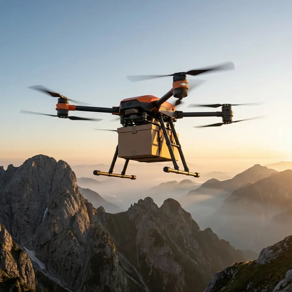
Why a cargo platform belongs in a survey conversation
At first glance, FlyCart 30 is a transport aircraft, not a classic mapping drone. But in remote forest work, the line between “survey platform” and “logistics platform” is thinner than many teams admit. Before sensors collect anything useful, people need batteries, communications gear, field instruments, marking supplies, replacement parts, and in some cases rope kits or sample containers moved up steep terrain. The most advanced survey workflow still fails if crews cannot sustain operations on the mountain.
This is where payload ratio becomes more than a brochure phrase. A heavy-lift drone that carries meaningful loads without bloating ground support requirements changes the shape of the mission. Competitor platforms in this category often look acceptable on paper, then lose practical value because they demand larger landing clearances, more cumbersome transport cases, or more delicate handling at elevation. FlyCart 30’s edge is not one single feature. It is how several systems support one another.
For forest teams working above lower-altitude operating norms, that systems thinking matters.
High altitude changes the math
Every rotorcraft feels altitude. Lower air density means less thrust efficiency, and that forces tradeoffs between payload, endurance, and safety margin. In dense forest, there is another problem layered on top: the safest place to put a drone is often not on the ground at all. Uneven slopes, wet undergrowth, loose rocks, and narrow ridgelines make conventional takeoff and landing procedures more restrictive than many planning documents suggest.
That is why the FlyCart 30’s winch system deserves more attention in survey-related use cases.
A well-integrated winch is not just convenient. In steep forest terrain, it lets crews deliver or retrieve gear without committing the aircraft to unstable landing zones. Operationally, that reduces rotor wash disturbance near the ground, limits exposure to branch strikes, and shortens time spent hovering while teams reposition. Compared with platforms that depend more heavily on full touchdown delivery, FlyCart 30 is better aligned with the realities of mountainous forest work.
For survey support missions, the significance is straightforward: less time forcing the aircraft into awkward ground interactions, more time using it as an aerial logistics node.
Dual-battery design is not glamorous, but it wins jobs
Most field teams obsess over maximum payload or headline range. I pay closer attention to what keeps the day moving after the third or fourth sortie when temperatures shift and terrain starts revealing all the assumptions made in the office.
That is where dual-battery architecture matters.
In high-altitude forest surveying, the mission rarely hinges on one dramatic flight. It depends on repeated, predictable cycles. A dual-battery setup improves continuity in two ways. First, it supports better power management under load. Second, it adds resilience if one battery behaves outside expectations in cold or variable conditions. That does not remove risk, but it gives operators a more robust energy framework than single-point power designs.
Some competing heavy-lift drones advertise capability aggressively yet feel fragile in daily rotation because their power strategy leaves less room for operational recovery. FlyCart 30’s dual-battery logic is better suited to professional field cadence. For teams pushing batteries at elevation, that translates into steadier sortie planning, fewer unnecessary aborts, and more confidence when scheduling battery swaps around weather windows.
Those are not small gains. In mountain forest environments, an hour lost in the wrong part of the day can collapse the rest of the mission.
Route optimization is where efficiency becomes safety
High-altitude forests punish lazy routing. A straight line on a map may cut across a ravine, pass through variable winds, or expose the aircraft to avoidable climbs that burn energy with no return. Route optimization is not a nice add-on for FlyCart 30 operations; it is central to whether the platform delivers practical value.
A capable cargo drone helps only if its flight path is designed around terrain, vegetation height, staging points, and the sequence of field tasks. For instance, carrying survey batteries to a ridge team is not just a point-to-point trip. It must be coordinated with descent options, return payload expectations, and the possibility that weather on the upper slope shifts before retrieval.
This is one area where the drone journalism reference becomes surprisingly relevant again. The Missouri course was experimental and short-lived, but it represented an attempt to build structured use around a new tool. Once regulation interrupted that structure, the course ended. The same pattern appears in commercial drone operations today. Teams that treat route planning as an afterthought often blame the aircraft when the real failure is procedural.
FlyCart 30 rewards disciplined planning. It is not a machine that erases bad decisions. It is a machine that scales good ones.
BVLOS potential only matters if the operation is mature enough
For remote forest corridors, BVLOS is the phrase everyone wants to discuss. And yes, for long logistics chains supporting survey crews across mountainous terrain, beyond visual line of sight operations can unlock real efficiency. But the keyword by itself is empty if the team lacks a sound operating framework.
A one-year university course ending because of FAA restrictions is a sharp reminder that airspace compliance is never a side issue. Back in that 2012–2013 period, the drone itself was not the limiting factor. The permission environment was. That lesson carries directly into FlyCart 30 deployment in forest survey support. If an operator is evaluating this aircraft for expanded route length or remote resupply, the mission design must begin with legal pathways, observer strategy where required, contingency procedures, and communication protocols.
In other words, BVLOS capability is only meaningful inside a compliant system.
The FlyCart 30 can fit that kind of mature workflow well because its cargo role naturally benefits from repeated route structures. Regularized routes are easier to assess, refine, and manage than improvised flights. For forest operators building longer support corridors, this gives the platform an advantage over less specialized aircraft that can technically fly but do not integrate as cleanly into recurring logistics patterns.
Emergency parachute systems are about preserving the operation, not just the airframe
Dense forest and steep slopes leave little room for graceful failure. If something goes wrong, the challenge is not merely avoiding damage to the drone. It is protecting ground crews, reducing uncontrolled descent risk, and preserving confidence in the entire program.
That is why an emergency parachute system has operational significance beyond safety theater.
In high-altitude survey support, crews are often spread across narrow work zones with limited shelter and constrained movement. A drone carrying tools or batteries overhead introduces real responsibility. An emergency parachute adds a final-layer mitigation measure when recovery options narrow quickly. It does not make a risky flight acceptable, but it can materially improve the consequence profile of a serious fault.
Compared with competitor platforms that may lean heavily on raw lift performance as the main selling point, FlyCart 30’s safety architecture is a stronger fit for civilian industrial operations where procedural accountability matters as much as output. That distinction matters in forestry, utilities, environmental surveys, and any operation where clients expect documented risk controls, not just mission completion.
The overlooked issue: training decides whether hardware performs
The source material on drone journalism in China and the United States points to a recurring industry gap. Even as universities and media organizations explored aerial reporting, formal course structures lagged. The Missouri program existed, but only briefly. In China, several institutions experimented with drone-related journalism activities, yet there was still no formal media-school drone course at the time discussed in the report.
That gap between interest and institutionalized training still shows up in commercial drone operations today.
A platform like FlyCart 30 can be wasted by teams that jump from light UAV experience straight into mountain logistics without building scenario-based training. High-altitude forest surveying demands more than knowing how to fly. Operators need load discipline, winch handling procedures, route adaptation skills, mountain weather judgment, battery rotation standards, and emergency response drills.
This is not academic overhead. It is the difference between a cargo drone that quietly becomes part of a reliable field system and one that delivers a few impressive flights before exposing weak process control.
If you are building a program around FlyCart 30, start with use-case training rather than generic aircraft familiarization. Simulate forest edge pickup. Practice suspended-load placement without ground landing. Build route plans around elevation changes and narrow weather windows. Document who makes the go/no-go decision when conditions drift. The hardware will perform better because the operation is clearer.
Where FlyCart 30 genuinely excels in this scenario
For high-altitude forest surveying support, FlyCart 30 is stronger than many competing heavy-lift options because it solves several field problems at once instead of maximizing only one metric.
Its payload-oriented design helps crews keep remote survey teams supplied. Its winch system reduces dependence on unreliable landing zones. Its dual-battery architecture supports repeated sortie cycles more effectively in demanding conditions. Its emergency parachute contributes to a safety case suitable for civilian industrial work. And its suitability for structured route operations makes it a more natural fit for mature BVLOS-oriented planning than ad hoc utility drones repurposed for cargo.
The result is not just “more capacity.” It is more usable capacity.
That distinction matters. In the mountains, theoretical performance is cheap. Usable performance is what keeps crews moving, sensors powered, and field days productive.
A practical deployment mindset
If I were setting up FlyCart 30 for a forest survey team at elevation, I would not begin by chasing the farthest route or the heaviest load. I would begin by stabilizing the operating pattern:
- define repeat supply corridors,
- use the winch wherever landing zones are compromised,
- maintain conservative battery thresholds,
- build alternates for sudden weather shifts,
- and train every crew member around the same route logic.
Only after that foundation is in place should the program expand into more advanced BVLOS structures or longer remote support chains.
That may sound less exciting than a headline performance claim, but it is exactly how industrial drone operations stop being experiments and start becoming infrastructure.
Anyone who wants to discuss how to structure that kind of field workflow can reach us directly through this FlyCart 30 operations chat.
The old drone journalism course from 2012–2013 is a reminder that technology can arrive before the surrounding system is ready. FlyCart 30 deserves better than that. In high-altitude forest surveying, it is not just a strong aircraft. It is a platform that makes sense when paired with serious planning, disciplined training, and a logistics-first mindset.
Ready for your own FlyCart 30? Contact our team for expert consultation.