FlyCart 30 in Windy Forest Survey Work: A Field Report
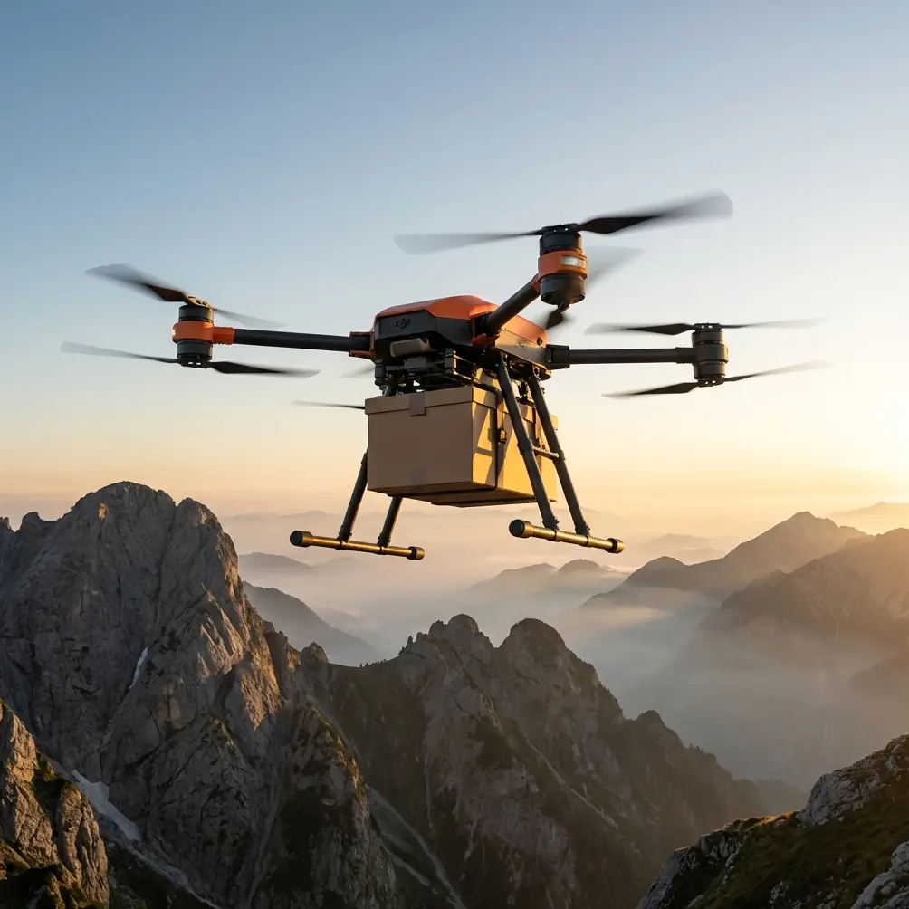
FlyCart 30 in Windy Forest Survey Work: A Field Report on Stability, Payload Discipline, and Smarter Imaging
META: A field report on using FlyCart 30 for windy forest survey missions, with practical insights on payload ratio, winch system value, dual-battery endurance, BVLOS planning, and how long-exposure imaging principles can improve data capture.
Forest survey work in wind exposes every weakness in a drone program.
On paper, many aircraft look capable. They claim useful payloads, decent range, and enough automation to make route planning feel straightforward. In the field, under moving canopy, shifting gusts, uneven launch zones, and limited visual line of sight, the story changes. That is where the FlyCart 30 becomes interesting—not because it is a conventional mapping drone, but because some of the traits designed for transport work translate surprisingly well to difficult survey logistics.
I am approaching this from the perspective of a logistics lead, not a brochure writer. If your job involves moving sensors, batteries, or support equipment into forested terrain while still trying to maintain clean data collection in windy conditions, the aircraft matters less as a headline and more as a system. The FlyCart 30 deserves attention for exactly that reason.
Why windy forest survey missions punish weak platforms
Forests create unstable air.
Wind does not pass through timber uniformly. It curls around trunks, lifts over ridgelines, breaks at clearings, and accelerates in narrow channels. That means the aircraft is rarely dealing with a single steady crosswind. It is absorbing constant micro-corrections. For survey teams, that affects more than flight comfort. It affects image consistency, route timing, battery margins, and the quality of any sensor deployment workflow.
This is where people often focus too narrowly on camera specs or top speed. In reality, the workflow begins much earlier. Can the platform move useful gear to a remote edge-of-operation point? Can it carry specialized payloads without collapsing the endurance plan? Can it operate with enough stability to support deliberate image-making rather than simply collecting whatever the air allows?
That last point deserves more attention than it usually gets.
What long-exposure photography teaches us about better aerial survey thinking
A recent photography piece made a useful argument: most people reduce long exposure to a cliché—light trails, smooth waterfalls, slow-shutter coastlines. The article’s real point was more valuable. Long exposure is not just about recording moving light. It can blur visual clutter, simplify composition, combine motion with stillness, and reveal effects the naked eye does not see.
That idea applies surprisingly well to forest survey work.
No, I am not suggesting every FlyCart 30 mission should become an artistic shoot. I am saying the underlying imaging principle matters. In forests, visual clutter is the default condition. Branch movement, layered canopy, variable light, and shifting shadows all compete for attention. Survey teams tend to think in terms of raw capture volume: more passes, more frames, more overlap. But the better question is what the image or sensor record is actually separating from the scene.
The photography article’s observation—that long exposure can “blur clutter” and “simplify the frame”—is operationally relevant because forest missions often suffer from too much information and not enough structure. When teams build workflows that deliberately account for motion versus stillness, they get more useful outputs. Sometimes that means selecting payload and timing combinations that minimize canopy distraction. Sometimes it means adjusting route logic to capture stable reference points while accepting motion in less critical zones. Sometimes it means planning around gust cycles instead of fighting them.
The principle is simple: not every moving element deserves equal visual weight.
That mindset changes how you use a platform like the FlyCart 30.
The FlyCart 30 advantage is not just lift. It is field discipline.
Compared with lighter survey-first aircraft, the FlyCart 30 stands out because it starts from a different design philosophy. It is built around carrying work into the field. In remote forest operations, that has direct survey value.
A strong payload ratio matters because the mission rarely consists of one aircraft and one sensor. Teams need batteries, charging gear, landing aids, communication equipment, spare mounting hardware, and sometimes compact environmental sensors or drop-deliverable support items for distributed crews. In bad terrain, the ability to move those items with one platform changes the whole tempo of the operation.
Competitor platforms in the smaller mapping category may be easier to classify as “survey drones,” but many of them become fragile once the task expands beyond pure image collection. They are efficient when the launch point is easy, the route is short, and the environment is clean. Windy forest work is none of those things. The FlyCart 30 excels when the mission includes both transport logic and data logic.
That matters because real survey productivity is often limited by setup friction, not by airspeed.
Why the winch system is more useful than it first appears
For forest teams, the winch system is one of the most practical features in the package.
At first glance, people associate a winch with logistics drops. Fair enough. But in timbered terrain, the bigger advantage is controlled vertical interaction without forcing the aircraft into the least forgiving part of the environment. Descending deep into uneven clearings or attempting ground contact near obstructed areas increases rotor wash effects, branch strike risk, and pilot workload. A winch allows the aircraft to hold a more stable position above the trouble zone while lowering equipment or retrieving items with more precision.
Operationally, this reduces exposure to the exact conditions that destabilize missions: turbulent air near canopy edges and improvised landing surfaces.
That is not a minor convenience. It can preserve battery margin, shorten hover uncertainty, and make distributed survey team support more repeatable. If a crew needs a battery, sensor accessory, radio, or marker line delivered to a narrow opening, the winch system keeps the aircraft out of the worst geometry. Competitor drones that require closer landing interaction simply ask more from the airframe and crew at the moment when the environment is least cooperative.
Dual-battery design and why redundancy changes planning
Windy forest missions punish battery assumptions. A route that looked safe in software can become tight once gust corrections, detours, and hover adjustments start stacking up.
This is why dual-battery architecture deserves more respect than it usually gets in search-friendly summaries. It is not only about extending flight time. It is about planning confidence and operational resilience. In rugged survey environments, a redundant power structure supports better decision-making because the crew is not forced into the same degree of all-or-nothing commitment. It gives the mission manager more room to preserve return margins, adapt route segments, and maintain safer thresholds for transport-plus-survey tasks.
For BVLOS-adjacent planning, that matters even more. I say “adjacent” deliberately because every operator still has to work inside local rules, approvals, and risk controls. But from a systems perspective, routes in forested areas often stretch operational awareness, communication reliability, and recovery logic. A dual-battery setup helps by making the aircraft less brittle in the face of changing conditions.
It does not replace discipline. It supports it.
BVLOS thinking starts with route optimization, not distance bragging
Too many discussions around BVLOS drift into range theater. That is the wrong emphasis for forest survey work.
The more useful question is whether the route is optimized to reduce unnecessary exposure to wind complexity, canopy interference, and turnaround inefficiency. A platform like the FlyCart 30 can support broader mission footprints, but the benefit only shows up when routes are built around terrain behavior. That means identifying where wind shear is likely to hit, where open corridors may improve consistency, and where payload delivery steps can be integrated without disrupting core data capture.
Route optimization is especially valuable when you borrow a page from the long-exposure mindset discussed earlier. Instead of trying to capture everything the same way, you prioritize mission segments differently. Stable anchor zones get one treatment. Dynamic canopy edges get another. Support drops or winch-lowered equipment are scheduled where hover confidence is strongest. The route becomes a structured sequence rather than a brute-force sweep.
That is how you get better output from a larger aircraft in a complex environment.
Emergency parachute thinking in commercial forestry operations
Safety features are easy to praise in broad terms and easy to misuse in planning.
An emergency parachute should never be treated as permission to accept poor decisions. What it does offer in commercial forest operations is a final mitigation layer when operating around difficult terrain and changing wind loads. For teams conducting civilian survey, inspection, or environmental work, that kind of contingency system has operational significance because remote mission areas are rarely forgiving. Recovery options narrow quickly once a platform encounters a serious fault above timber.
In that context, the parachute is not a talking point. It is part of a risk stack that includes route design, battery discipline, payload management, weather thresholds, and crew communication.
The FlyCart 30 compares well here because its broader mission design acknowledges that heavy-work aircraft need more than nominal flight capability. They need structured safeguards. In forest survey support, that is exactly the right philosophy.
Where FlyCart 30 fits best in a survey program
I would not position the FlyCart 30 as the universal answer to every forest mapping requirement. That would miss the point.
Its strongest role appears when the survey mission is operationally messy:
- windy terrain
- remote launch or resupply constraints
- mixed logistics and imaging requirements
- crews spread across difficult access points
- sensor or support equipment that benefits from controlled winch deployment
- mission planners who need stronger payload tolerance than lightweight mapping platforms can offer
That is where this aircraft separates itself from competitors. Not in a lab. In the friction between plan and terrain.
If your work is narrowly defined, close to road access, and centered on one small imaging payload, a lighter specialist platform may still be more efficient. But once the forest mission becomes a full field operation rather than a clean demonstration flight, the FlyCart 30 starts solving problems that smaller systems simply leave on the crew.
A practical note on imaging strategy in wind
The photography reference I mentioned earlier stays useful here. It argued that beginners often treat long exposure as a fixed style, when in fact it is a method for reshaping how motion appears—simplifying clutter, balancing stillness and movement, and revealing what normal vision misses.
That is a smart framework for aerial survey crews.
In windy forests, not every frame should be judged only by how much detail it contains. Sometimes the better question is whether the capture strategy reduces distraction and isolates the feature that matters. This may influence timing, altitude decisions, orbit structure, and payload choice. It may even affect when you pause and wait for a cleaner wind cycle instead of forcing a pass that creates noisy, low-confidence data.
That level of judgment is where experienced teams separate themselves.
If you are evaluating whether the FlyCart 30 suits your own forest survey workflow, it helps to discuss the operation as a whole rather than comparing isolated specifications. For teams building a practical deployment plan, this direct WhatsApp line is often the quickest way to sort through payload fit and route design questions: message an operations specialist.
Final field take
The FlyCart 30 earns its place in windy forest survey work because it brings transport-grade capability into a mission type that often suffers from underestimating logistics. Its payload ratio supports real field demands. Its winch system reduces risk at awkward delivery or retrieval points. Its dual-battery architecture improves planning resilience. Its emergency parachute adds a meaningful contingency layer. And when route optimization is taken seriously, it becomes far more than a heavy platform moving through trees.
The imaging lesson from the long-exposure article sharpens the case. Better aerial work is not just about collecting more visual data. It is about managing motion, clutter, and timing so the mission reveals what ordinary viewing would miss. That is exactly the kind of thinking complex forest survey operations require.
The FlyCart 30 is not interesting because it does everything. It is interesting because in the hardest civilian field conditions, it does the things that keep the rest of the operation viable.
Ready for your own FlyCart 30? Contact our team for expert consultation.