Surveying Forests in Extreme Temperatures with FlyCart 30
Surveying Forests in Extreme Temperatures with FlyCart 30: What Actually Matters in the Field
META: Practical FlyCart 30 insights for forest surveying in extreme temperatures, with field-focused guidance on payload strategy, route planning, winch use, dual-battery resilience, and safer operations.
Forest surveying sounds straightforward until the aircraft is half a ridge away, the temperature swings hard between shaded valleys and exposed canopy, and the cargo you’re moving is not optional. Batteries, environmental sensors, sampling tools, emergency supplies, spare GNSS gear, marking kits, radio repeaters—none of it is glamorous, all of it matters.
That’s where the FlyCart 30 enters the conversation in a more useful way than most product summaries allow.
I’m writing this from the perspective of a logistics lead, not someone dazzled by spec-sheet theater. In forestry work, the question is rarely “Can the drone fly?” The real question is whether it can support a survey program reliably when heat, cold, elevation, moisture, and distance all start compounding risk. For teams working in extreme temperatures, the FlyCart 30 is interesting because it sits at the intersection of cargo movement, route discipline, and operational resilience.
And right now, that practical lens matters more than ever. Commercial UAV Expo’s 2026 conference program, announced for September 1–3, 2026, is built around “Actionable Insights,” with the agenda shaped by community feedback and a clear emphasis on real-world operations. That shift is worth paying attention to. It reflects where the commercial UAV market has matured: less appetite for abstract capability, more demand for methods that hold up on actual jobsites. Forest surveying with a cargo platform like the FlyCart 30 is exactly the sort of operation that benefits from that mindset.
The forest problem most teams underestimate
Extreme-temperature forestry missions are rarely defeated by a single dramatic failure. They erode. Small inefficiencies stack up.
A crew begins with a simple objective: place sensors across a remote stand, retrieve data modules from another section, and deliver replacement power packs before weather closes in. On paper, it’s manageable. In practice, the terrain creates awkward landing options, temperature fluctuations affect battery behavior, and every extra minute spent repositioning crews burns daylight and raises exposure.
The common mistake is treating a logistics drone as a flying truck. In forests, it behaves more like a force multiplier for precise movement. That distinction changes planning.
A FlyCart 30 operation in this environment is not just about payload ratio. It is about how much useful mission effect you gain for every unit of energy, time, and risk invested. Carrying too much creates inefficiency. Carrying too little creates repeat trips. The right balance often depends on route optimization and whether the aircraft’s winch system can eliminate the need for unstable landings in uneven or obstructed areas.
That last point is not theoretical. Dense forest operations often present no clean touchdown zone at the exact point where equipment needs to be delivered. If your team is trying to drop a package of sampling equipment into a narrow opening between trees or lower a sensor node near a steep embankment, the winch becomes an operational tool, not a convenience feature. It can reduce rotor wash impact on loose debris, avoid contact with uneven ground, and shorten the time spent hunting for a marginal landing site.
Why extreme temperatures expose weak planning
Cold weather and high heat punish sloppy assumptions in different ways.
In cold conditions, available battery performance can tighten just when the mission profile asks for climbing, crosswinds, and precise hover work. In heat, power systems may face a different kind of stress, especially on repeated trips or long loiter periods over uneven terrain. Add elevation, and your margins narrow further. This is why dual-battery architecture matters operationally. It is not just redundancy in the abstract. It can support continuity of flight operations and improve decision confidence when you are scheduling sorties in narrow weather windows.
For forestry teams, that has a downstream effect: fewer interruptions in the rhythm of survey work. If a crew on the ground is waiting for a delivered lidar target, field tablet, battery pack, or replacement sensor, every delay ripples into data quality and staffing efficiency.
A drone like the FlyCart 30 earns its place when it lets the survey plan remain coherent even as environmental conditions become less cooperative.
A field scenario that changed how I think about sensors
One of the more telling moments I’ve seen in forest logistics involved a deer breaking from cover near a drop corridor just as the aircraft was approaching the release zone. It wasn’t dramatic. No crash, no near-disaster. But it was a real reminder that forests are dynamic spaces, not sterile test environments.
The aircraft’s sensing and obstacle-awareness behavior mattered in that moment because route discipline alone was not enough. The mission had been planned around topography and trees. Wildlife added a variable no one had scheduled.
This is one reason route optimization in forests cannot be reduced to drawing the shortest line between two points. The best route is often the one that preserves obstacle margin, maintains cleaner sight geometry for monitoring, and gives the aircraft a more predictable path through mixed vegetation and terrain breaks. When the environment changes suddenly—whether from movement below, shifting wind, or unplanned crew activity—sensor-informed navigation becomes part of operational safety, not just convenience.
The FlyCart 30’s real role in surveying: support, not substitution
Let’s be clear about what the FlyCart 30 should and should not do in a forestry survey program.
It should not replace your core survey aircraft if your primary mission is data capture. If you are running dedicated lidar, photogrammetry, multispectral, or thermal mapping workflows, those systems still drive the data side.
What FlyCart 30 can do is remove the frictions that often weaken those missions:
- moving batteries to ridge teams without a full hike,
- placing remote communications equipment,
- delivering field calibration targets,
- transporting environmental sensors for temporary deployment,
- retrieving memory modules or failed instruments,
- carrying rope lines or lightweight support tools to inaccessible spots,
- supporting remote teams during long corridor or plot-based survey days.
That support function sounds secondary until you calculate how much lost productivity comes from moving people instead of equipment. On a multi-day forest campaign, logistics drag is often the hidden cost center. A cargo drone can compress that drag if the routes are planned intelligently and the payloads are selected with discipline.
Payload ratio is not just a number
The phrase “payload ratio” gets thrown around casually, but in forest operations it deserves a stricter interpretation.
A good payload decision is one where the cargo contributes directly to the next irreplaceable step in the survey. If the load does not unblock work, protect schedule, or reduce field risk, it may not belong on that sortie. In other words, payload value matters more than payload mass alone.
For example, in extreme cold, flying a smaller but mission-critical load—say, replacement power modules and a compact metrology kit—may create more value than trying to maximize every trip with miscellaneous gear. In heat, minimizing hover time during winch delivery can matter more than squeezing in one extra item.
This is where experienced operators separate themselves from enthusiastic beginners. The FlyCart 30 is most effective when missions are built around essential cargo sequencing, not maximum carrying ambition.
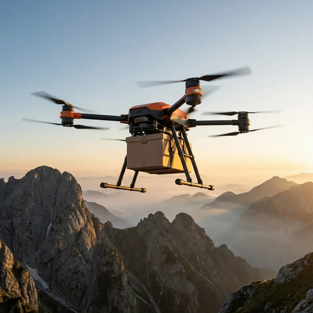
Winch system: where forest operations become practical
For many wooded sites, the winch system is the feature that turns a “possible” operation into a repeatable one.
A forest floor can be muddy, sloped, cluttered with roots, or boxed in by trunks and low branches. Even where an aerial view suggests a landing gap, the actual conditions below may be unusable. A controlled lowering operation gives the crew more options. It can also reduce disturbance to the site, which matters when survey work intersects with ecological monitoring or protected habitat protocols.
Operationally, the winch helps in three specific ways:
- It keeps the aircraft out of problematic ground effect zones near brush and debris.
- It shortens decision time at the destination because the crew does not need to validate a full landing area.
- It improves reach into partially obstructed terrain pockets where a conventional touchdown would be impractical.
For forest teams trying to maintain tempo across multiple drops in a single day, those gains add up.
BVLOS thinking starts long before approvals
BVLOS is often discussed as a regulatory milestone. In practice, forest operators should think about it as a planning discipline first.
Whether your current operation is conducted within visual constraints or moving toward expanded frameworks, the habits that make long-distance forest logistics safer are the same: route standardization, contingency sites, weather gates, communication check intervals, and cargo prioritization. The FlyCart 30 becomes more useful as these procedures mature.
This is another reason the industry’s broader shift toward practical education matters. The announcement around Commercial UAV Expo’s 2026 program emphasized practical takeaways shaped by community feedback. That is exactly the kind of industry signal forestry teams should respect. Real-world operations—especially in remote environments—improve fastest when operators share methods, not just achievements.
If your team is refining FlyCart 30 workflows for remote survey support and wants to compare route-planning approaches or deployment setups, it can help to message a field operations specialist here.
Emergency parachute and the meaning of controlled risk
No serious operator treats safety systems as permission to be reckless. But in forestry environments, layered mitigation matters.
An emergency parachute belongs in the discussion because forest missions often involve uneven terrain, limited recovery access, and fewer clean alternatives when a flight does not go as planned. Its operational significance is simple: it supports a more controlled outcome during severe failures and helps frame more responsible risk management for flights over difficult ground.
That does not eliminate the need for conservative route design. It reinforces it. Safety systems have the most value when paired with disciplined mission selection, clear abort criteria, and sensible weather thresholds.
What a good FlyCart 30 forest workflow looks like
The best deployments I’ve seen follow a pattern.
The day starts with a hard sort of cargo into three classes: mission-critical, productivity-enhancing, and deferrable. Routes are then built around terrain, tree density, and communication reliability, not merely distance. Temperature effects are considered before launch, not explained afterward. Deliveries into poor landing environments are assigned to winch operations by default. Dual-battery readiness is treated as part of sortie continuity. Emergency procedures are discussed in plain language.
Then the team watches the forest itself.
That sounds obvious, but forests are full of moving variables: wildlife, workers on foot, changing light under canopy edges, isolated gusts in saddles and breaks, humidity shifts near water, and visual ambiguity where tree lines open unexpectedly. The operators who perform best are the ones who keep the mission plan rigid where it should be rigid and flexible where the environment demands it.
The bigger takeaway
FlyCart 30 makes the most sense in forest surveying when it is used to protect the survey mission from logistical friction. Not to show off lift capability. Not to replace specialized mapping aircraft. To keep the work moving when distance, temperature, terrain, and timing are all trying to slow it down.
That is also why the industry conversation around practical education deserves attention. A conference program built around “Actionable Insights,” shaped by community feedback and centered on real-world drone operations, points to a mature commercial UAV market. Operators want fewer slogans and more proven field logic. Forest teams should want the same.
If you’re evaluating FlyCart 30 for extreme-temperature surveying support, focus on the details that actually decide outcomes: payload ratio discipline, winch-based delivery strategy, route optimization, dual-battery resilience, BVLOS-ready procedures, and emergency recovery planning. Those are not side notes. They are the operation.
Ready for your own FlyCart 30? Contact our team for expert consultation.