FlyCart 30 Guide: Surveying Power Lines Remotely
FlyCart 30 Guide: Surveying Power Lines Remotely
META: Learn how the DJI FlyCart 30 transforms remote power line surveys with BVLOS capability, winch delivery, and dual-battery endurance. Full tutorial inside.
TL;DR
- The FlyCart 30 enables efficient power line surveys across rugged, inaccessible terrain using BVLOS route optimization and a 30 kg payload capacity.
- Pre-flight cleaning of safety sensors is a critical but overlooked step that prevents mid-mission failures in dusty field environments.
- Dual-battery redundancy and an emergency parachute system keep equipment and data safe during extended remote operations.
- This tutorial walks you through the complete workflow—from pre-flight prep to post-survey data handling—so you can deploy with confidence.
Why Remote Power Line Surveys Need a Better Solution
Traditional power line inspections in remote corridors are expensive, dangerous, and slow. Helicopter flyovers burn through fuel budgets. Ground crews face treacherous terrain, wildlife hazards, and multi-day treks just to reach a single tower. When a single inspection cycle across 50 km of remote transmission lines can take weeks using conventional methods, the operational math stops making sense.
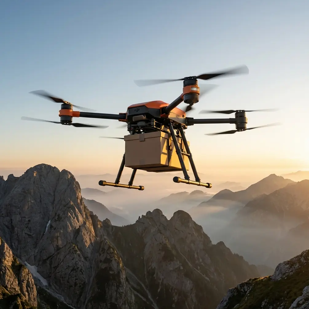
The DJI FlyCart 30 changes that math entirely. This heavy-lift cargo drone carries survey payloads, replacement components, and sensor packages directly to inspection points—without requiring road access, landing zones, or manned aircraft. This guide covers exactly how to plan, prepare, and execute remote power line surveys using the FlyCart 30, step by step.
I'm Alex Kim, logistics lead on multiple infrastructure survey deployments. What follows is the workflow my team uses in the field.
Pre-Flight Preparation: The Cleaning Step Everyone Skips
Here's something most operators learn the hard way: dust and debris on obstacle-avoidance sensors cause more mission aborts than mechanical failures. Before every flight in remote environments, you need a deliberate cleaning protocol for every safety-critical surface on the aircraft.
Sensor and Safety System Cleaning Checklist
- Binocular vision sensors (all six directions): Wipe with a microfiber cloth and inspect for scratches or film buildup. Even a thin layer of pollen or mineral dust degrades detection range by up to 35%.
- Infrared sensing arrays: Use compressed air first, then a dry lens cloth. Moisture-based cleaners can leave residue that creates false obstacle readings.
- Emergency parachute deployment cover: Check that the release panel is free of grit, mud, or ice. A jammed parachute cover in a dual-motor failure scenario turns a recoverable incident into a total loss.
- Propeller root clamps and motor ventilation ports: Clear debris to prevent overheating during high-payload climbs.
- Winch system cable and hook mechanism: Inspect for fraying, corrosion, or dirt in the spool housing. A stuck winch at 200 m altitude over a canyon is a problem you don't want to solve in real time.
Expert Insight — Alex Kim: "We laminate our cleaning checklist and attach it physically to the transport case. In remote deployments, you won't have cell service to pull up a PDF. Make your process tactile and unavoidable."
This cleaning step takes 8–12 minutes. It has saved our team from at least three sensor-related mission failures across two seasons of power line work.
Step 1: Route Planning and BVLOS Configuration
Remote power line corridors are rarely straight. They cross ridgelines, river valleys, and forested slopes. Effective route optimization starts with terrain data, not just GPS waypoints.
Building Your Survey Route
- Import GIS corridor data into DJI DeliveryHub or your mission planning software. Overlay the transmission line path with elevation models.
- Set waypoint altitude offsets based on terrain following. For power line surveys, maintain a minimum 15 m vertical clearance above the highest conductor at each span.
- Define BVLOS segments and identify required visual observer positions if regulations demand them. The FlyCart 30 supports BVLOS operations up to 28 km with its integrated 4G/5G communication module.
- Establish contingency waypoints at intervals no greater than 5 km—these are pre-designated safe landing zones the aircraft will target if signal is lost or battery thresholds trigger a return.
Payload Configuration for Survey Missions
The FlyCart 30's payload ratio is one of its defining advantages. With a maximum takeoff weight of 95 kg and a maximum payload of 30 kg, you have substantial capacity for multi-sensor packages.
Typical survey payload configurations include:
- LiDAR scanner + RGB camera: Combined weight approximately 8–12 kg, leaving capacity for spare batteries or hardware deliveries to tower crews.
- Thermal imaging package: For hotspot detection on connectors and insulators, typically 3–5 kg.
- Replacement insulator or hardware delivery: Use the winch system to lower components to tower crews without requiring the aircraft to land.
Step 2: Configuring Dual-Battery and Emergency Systems
The FlyCart 30 operates on a dual-battery architecture that isn't just about extended flight time—it's a redundancy system. If one battery pack fails or reaches critical voltage, the second pack sustains flight long enough to execute an emergency landing at a contingency waypoint.
Battery Setup Protocol
- Verify both battery packs are at 100% charge and within 2% state-of-charge of each other before insertion. Mismatched packs create uneven power draw.
- Record battery cycle counts. Packs beyond 200 cycles should be retired from remote BVLOS missions and relegated to short-range training flights.
- With a 30 kg payload, expect approximately 16 minutes of flight time. With a lighter survey-only payload of 10 kg, endurance extends to approximately 28 minutes.
Emergency Parachute Verification
The FlyCart 30 includes an integrated emergency parachute system rated for full-weight deployment. Before each remote mission:
- Confirm the parachute status indicator shows green in the pilot interface.
- Verify the deployment altitude threshold is set to no lower than 50 m AGL for safe canopy inflation.
- Test the manual trigger on the remote controller—do not skip this check just because the automated system tested fine yesterday.
Pro Tip: In canyon or valley environments, set your parachute deployment altitude higher—80 m AGL minimum. Downdrafts near cliff faces can accelerate descent beyond the parachute's designed sink rate if deployed too low.
Step 3: Executing the Power Line Survey
With cleaning complete, route loaded, and systems verified, launch follows a standard sequence:
- Power on and wait for full GPS lock—minimum 14 satellites for BVLOS reliability.
- Verify obstacle avoidance is active on all axes. The FlyCart 30's sensing system covers 360° horizontal and vertical detection.
- Begin automated route and monitor telemetry for battery voltage, motor temperatures, and wind speed.
- At each survey waypoint, the aircraft can hover while onboard sensors capture imagery, LiDAR point clouds, or thermal data.
- For hardware delivery to tower crews, engage the winch system at the designated drop point. The winch supports lowering payloads up to 40 m below the aircraft with precision speed control.
Real-Time Monitoring Priorities
| Telemetry Parameter | Acceptable Range | Action if Exceeded |
|---|---|---|
| Battery voltage per cell | 3.5 V – 4.2 V | Initiate return to home |
| Motor temperature | Below 85°C | Reduce speed or payload |
| Wind speed | Below 12 m/s | Hold position or land |
| GPS satellite count | 14+ satellites | Do not launch below 12 |
| Signal strength (4G) | Above -90 dBm | Switch to backup frequency |
Technical Comparison: FlyCart 30 vs. Traditional Survey Methods
| Factor | FlyCart 30 Drone Survey | Helicopter Survey | Ground Crew Patrol |
|---|---|---|---|
| Deployment time | 30 minutes from arrival | 2–4 hours (fuel, crew, permits) | 1–3 days per corridor |
| Cost per km surveyed | Low | Very high | Moderate |
| Terrain limitation | Minimal (vertical takeoff) | Requires approach corridors | Blocked by rivers, cliffs |
| Payload delivery | Yes (30 kg, winch capable) | Limited, no precision drop | Manual carry only |
| Safety risk to personnel | No humans airborne | Pilot + observer at risk | Falls, wildlife, fatigue |
| Data resolution | High (low altitude, stable hover) | Moderate (speed + vibration) | High (but slow) |
| BVLOS capability | Yes, up to 28 km | N/A (manned) | N/A |
Common Mistakes to Avoid
1. Skipping the pre-flight sensor cleaning. This is the single most common cause of preventable mission aborts in dusty remote environments. Build it into your checklist as a non-negotiable step.
2. Overloading payload without recalculating endurance. The difference between a 10 kg and 30 kg payload can cut flight time nearly in half. Always recalculate your route feasibility after finalizing payload weight.
3. Setting identical outbound and return altitudes. Power line corridors often have different wind conditions at different altitudes. Optimize your return altitude separately—often 20–30 m above outbound altitude reduces headwind drag on the return leg.
4. Ignoring battery cycle counts for BVLOS missions. A battery that performs fine on a 2 km training flight may voltage-sag dangerously under sustained load at 15 km from home. Retire high-cycle batteries from remote operations early.
5. Relying solely on automated obstacle avoidance near towers. Guy-wires, thin conductors, and bird deterrent devices can fall below the detection threshold of vision-based sensors. Always pre-map known obstacles into your flight plan as virtual barriers.
Frequently Asked Questions
Can the FlyCart 30 operate in rain during power line surveys?
The FlyCart 30 carries an IP55 ingress protection rating, which means it handles rain and dust exposure during flight. However, heavy rain degrades LiDAR and optical sensor performance. Schedule survey data-capture segments for dry windows, and use rain-rated flights only for transport or delivery legs.
How does the winch system work for delivering parts to tower crews?
The integrated winch lowers payloads on a cable up to 40 m below the aircraft. The operator controls descent speed remotely, and the crew on the tower or ground unhooks the delivery. This eliminates the need for the drone to land in uneven terrain—critical in canyon or mountainside tower locations.
What regulatory approvals are needed for BVLOS power line surveys?
Requirements vary by jurisdiction, but most aviation authorities require a specific BVLOS waiver or operational authorization. You will typically need to demonstrate reliable command-and-control links (the FlyCart 30's 4G/5G module supports this), a detect-and-avoid capability, and a contingency management plan including the emergency parachute system. Engage your national aviation authority early—approval timelines can range from weeks to months.
Ready for your own FlyCart 30? Contact our team for expert consultation.