FlyCart 30 for Urban Solar Farm Surveying: What Counter
FlyCart 30 for Urban Solar Farm Surveying: What Counter-Drone News Reveals About Safer UAV Operations
META: A technical review of FlyCart 30 for urban solar farm surveying, using new counter-drone developments to assess BVLOS safety, payload efficiency, winch workflows, and airspace risk.
Urban solar farm surveying has changed. The aircraft is no longer the only variable that matters. Detection, airspace control, and resilience against interference now shape mission planning just as much as payload, endurance, and route logic.
That is why two recent counter-UAS developments deserve attention from anyone evaluating the DJI FlyCart 30 for urban solar operations. One report highlights a high-power microwave system described as capable of taking down drone swarms in seconds at a major Chinese defense equipment R&D and production base linked to the 081 Group. Another details DroneShield’s integration of Robin Radar into a layered drone airspace protection stack, with radar positioned as part of a broader drone-detection ecosystem.
At first glance, neither story is about the FlyCart 30. Look closer, and both are directly relevant. If you are surveying solar assets in dense urban or semi-urban environments, the operating question is no longer just, “Can this drone carry what I need?” The sharper question is, “Can this platform complete the job reliably inside an airspace environment that is becoming more monitored, more defended, and less tolerant of ambiguity?”
That is where the FlyCart 30 becomes interesting.
Why these two news items matter to FlyCart 30 operators
The first report is striking because of its emphasis on low-cost counter-drone effect and speed. The phrase suggesting a drone can be effectively neutralized for only a few yuan, combined with the claim that high-power microwave technology can defeat swarming drones in seconds, points to a simple operational truth: anti-drone capability is becoming faster, cheaper, and more scalable.
For urban solar survey teams, that matters in two ways.
First, it raises the penalty for poor identification. A large logistics UAV operating near critical infrastructure can be misread if the mission profile is not tightly controlled and properly coordinated. FlyCart 30 is not a small quadcopter used casually over a vacant lot. It is a serious aircraft with a utility-centered design, visible presence, and mission profile that can overlap with infrastructure, rooftops, industrial zones, and regulated corridors. In an environment where defensive systems are getting quicker and more economical, professionalism in authorization, flight planning, and conspicuity is not optional.
Second, the microwave-swarm angle highlights the growing distinction between hobby-grade assumptions and enterprise-grade reality. Swarms stress defenses because they create target density and decision pressure. Urban solar work creates a different challenge: clutter. Roof structures, reflective panel fields, adjacent buildings, utility lines, temporary construction cranes, and moving vehicles all complicate situational awareness. If counter-drone systems are evolving to respond rapidly to perceived threats, operators need aircraft and workflows that reduce uncertainty from the start.
The second news item adds the missing half of the picture. DroneShield’s partnership with Robin Radar is about layered detection, not hard kill. That detail is operationally significant. It suggests that modern airspace protection is less about one sensor doing everything and more about fusing multiple inputs so an operator or security system can classify what is flying, where it is going, and whether it belongs there.
For a FlyCart 30 mission over or around urban solar assets, that means detection infrastructure is becoming more capable of seeing you earlier and tracking you more accurately. If your operation is legitimate, that is not bad news. In fact, it rewards aircraft that are stable, predictable, and easy to integrate into disciplined operating procedures.
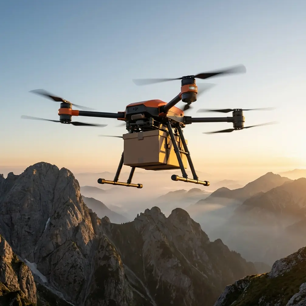
The FlyCart 30’s real advantage is not raw lift alone
Many buyers look at the FlyCart 30 and stop at payload. That is understandable. Payload ratio is still one of the cleanest ways to judge whether a logistics platform is efficient. But for solar farm surveying in urban environments, raw lift is only the starting point.
The more meaningful advantage is that FlyCart 30 can consolidate tasks that would otherwise require separate flights, separate crews, or repeated site access. That directly affects surveying efficiency.
An urban solar survey is rarely just image capture. Teams may need to move compact instruments, drop lightweight sensors, position line markers, deliver spare field tools to elevated locations, or support inspection workflows where access is awkward. This is where the winch system matters more than spec-sheet comparisons usually admit.
A winch-equipped UAV changes how work gets done around rooftop arrays, fenced substations, parking-canopy solar structures, and mixed-use commercial properties. Instead of forcing a landing in a constrained area, the aircraft can maintain a safer hover and lower equipment precisely. In urban operations, that is not a convenience feature. It is risk reduction. Less landing exposure means fewer interactions with debris, pedestrians, rooftop obstructions, and improvised touchdown zones.
Competitors often advertise carrying capacity, but not all of them translate that capacity into controlled last-meter delivery. The FlyCart 30’s winch-based workflow is where it can outperform aircraft that look similar in a headline comparison. For solar survey teams, the difference between “can carry” and “can place accurately without landing” is substantial.
Counter-drone trends make route discipline a competitive edge
The DroneShield-Robin Radar story deserves a closer read from a mission-planning perspective. The key phrase is “layered airspace protection.” In practice, layered systems reduce the odds that an aircraft can slip through unnoticed. For legitimate commercial operators, the response should not be anxiety. It should be cleaner route optimization.
Urban solar missions often tempt teams into improvisation. A crew arrives, identifies the next roof section, notices changing wind around a building edge, reroutes around a crane, then adjusts again to avoid a nearby maintenance crew. Small changes accumulate. Before long, the flight path that was filed is not the path that is being flown.
That gap matters more in a sensor-rich airspace.
FlyCart 30’s value here is partly about mission stability. On larger and more complex sites, route optimization is not just an endurance issue; it is an airspace transparency issue. Predictable corridors, disciplined altitude management, and repeatable approach profiles create a flight signature that is easier to recognize as intentional and authorized. That reduces confusion for nearby security teams and infrastructure managers.
This is especially relevant if your organization is pushing toward BVLOS operations or BVLOS-style workflows within approved frameworks. In that context, the aircraft is part of a larger compliance architecture. Dual-battery redundancy, stable hovering for winch drops, and emergency parachute logic are not isolated features. Together, they support a mission profile that looks more professional to regulators, site owners, and security stakeholders.
Solar sites in urban zones need resilience, not just efficiency
The high-power microwave report may sound extreme, but its lesson is practical. Airspace around critical or sensitive areas is getting harder by design. Some urban solar sites sit close to transportation corridors, industrial campuses, utility assets, or government-adjacent zones. Even if your target site is ordinary, the surrounding environment may not be.
That is why resilience should outrank speed in any FlyCart 30 evaluation.
Dual-battery architecture matters because urban surveying often forces conservative decision-making. Wind shadow from buildings can shift abruptly. Takeoff and recovery windows can be narrow. Holding position while coordinating a drop or waiting for a cleared movement path consumes time. Redundancy in the power system buys operational margin where rushed missions usually fail.
Emergency parachute capability also deserves more attention than it gets. In open rural fields, a malfunction and descent event are already serious. In a city-facing solar environment, they are potentially unacceptable. Rooftops, vehicles, public walkways, and neighboring properties compress the tolerance for failure. A parachute system is not there to make a risky mission acceptable. It is there because enterprise UAV operations need a last-resort safety layer when consequence is high.
Those features gain even more importance when counter-UAS awareness is rising. The better nearby systems become at detecting unusual flight behavior, the more valuable it is to operate a platform designed for controlled contingencies rather than marginal improvisation.
What FlyCart 30 does especially well for survey support
If the job is pure photogrammetry, there are lighter aircraft that may be easier to deploy. That should be said plainly. But solar survey support in urban settings is often a blended mission. Inspection, measurement support, equipment transfer, access workaround, and time-sensitive delivery can all happen on the same day.
This is where FlyCart 30 separates itself.
It supports a broader mission envelope than aircraft built only for cameras. For teams managing urban solar portfolios, that flexibility reduces fleet fragmentation. One platform can support pre-inspection logistics, active survey operations, and site-response tasks when crews discover a failed sensor, loose component, or inaccessible position that needs immediate attention.
That broader mission envelope also changes staffing efficiency. A platform that combines utility lift with controlled delivery can reduce the number of rooftop ascents required from ground personnel. That has a direct safety implication, especially on commercial buildings where access paths are complex and every extra climb introduces avoidable exposure.
If you want to pressure-test whether FlyCart 30 fits your workflow, the right question is not, “Is it the biggest or strongest option?” It is, “Does it reduce total operational friction across the entire survey day?” In many urban solar scenarios, the answer is yes.
The new airspace reality favors disciplined enterprise platforms
The two reference stories point in the same direction from different angles.
One shows counter-drone effect becoming cheaper and faster, with a report centered on a high-power microwave capability said to neutralize swarms in seconds. The other shows drone detection becoming more layered through the pairing of DroneShield and Robin Radar. Faster defeat on one side. Better detection on the other.
Put together, they describe an airspace that is less permissive than before.
That is not a reason to avoid UAV deployment. It is a reason to choose platforms and operating methods that belong in serious infrastructure work. FlyCart 30 fits that shift better than many aircraft that look attractive only in isolated spec categories. Its strength is not just payload. It is operational composure: controlled delivery via winch, support for structured route planning, safety-oriented redundancy, and the ability to handle mixed-task field realities without constant reconfiguration.
For urban solar farm surveying, that combination matters because the mission sits at the intersection of infrastructure, regulation, and public visibility. Operators need aircraft that can work efficiently while projecting procedural legitimacy. A small consumer-style drone may be easier to launch, but it often lacks the workflow depth to support complex site operations. A heavier industrial platform without refined delivery logic may carry more, yet create new problems at the point of use. FlyCart 30 lands in a more useful middle ground for many teams.
If your operation is expanding into denser environments, this is the moment to upgrade not just the aircraft, but the operating philosophy around it. Coordinate early. Optimize routes before arriving on site. Use the winch to avoid unnecessary landings. Build BVLOS readiness through disciplined procedures, not wishful paperwork. Treat dual-battery and emergency parachute systems as part of mission design, not marketing bullets. And if you need a practical discussion around urban solar workflows, fleet fit, or deployment planning, you can reach out here via direct project chat.
The larger lesson from this week’s counter-UAS news is simple. Airspace is getting smarter, more defensive, and less forgiving. That raises the bar for everyone. For FlyCart 30 operators working around urban solar assets, the aircraft still matters. But the operators who win will be the ones who pair the platform’s utility strengths with cleaner procedures, tighter route discipline, and a sharper understanding of the security environment around every flight.
Ready for your own FlyCart 30? Contact our team for expert consultation.