FlyCart 30 for Coastal Venue Surveys: What an Emergency AED
FlyCart 30 for Coastal Venue Surveys: What an Emergency AED Network in Sweden Reveals About Real-World Drone Reliability
META: A field-led case study on using FlyCart 30 for coastal venue surveys, drawing lessons from Sweden’s expanding AED drone network, BVLOS planning, payload strategy, weather shifts, and operational reliability.
I’ve spent enough time around logistics aircraft to know that most drone discussions go wrong in the first five minutes. People jump straight to airframe specs, then payload limits, then range. Useful, yes. But for actual operations—especially in coastal venue surveying—the better question is simpler: what kind of mission profile proves a drone can be trusted when conditions stop being tidy?
That is why a seemingly unrelated development in Sweden deserves attention from anyone evaluating the FlyCart 30.
At the end of April 2026, Västra Götaland Region opened a new Everdrone base in Borås. That made Borås the fourth E3 base in the region’s autonomous AED delivery network, extending coverage to about 300,000 residents. The drones are dispatched in response to emergency calls and carry defibrillators to the scene.
On the surface, that is a medical response story, not a venue survey story. But operationally, the overlap is real. A network that exists to move an AED after an emergency call lives or dies on dispatch discipline, route confidence, airspace predictability, and aircraft behavior when the environment changes unexpectedly. Those same factors shape whether a FlyCart 30 is merely impressive on paper or genuinely useful for surveying venues along a windy coast.
I’ll explain through a recent coastal venue workflow where the aircraft’s logistics DNA mattered more than marketing language ever could.
Why a Swedish emergency network matters to FlyCart 30 users
The Borås launch tells us two things that are easy to miss.
First, scale changes the meaning of reliability. Adding a fourth base to reach roughly 300,000 residents is not about a one-off demonstration flight. It signals a repeatable service model. When a drone is integrated into emergency call response, consistency matters more than spectacular performance on a calm day. Dispatch windows are tight. Flight paths have to be credible. The aircraft and the operating system around it must perform without requiring heroic improvisation every time.
Second, payload usefulness matters more than payload bragging rights. In this case, the mission is to deliver an AED, not just “fly something somewhere.” That distinction is important for FlyCart 30 operators. Coastal venue work often sounds lightweight—survey a beach club, inspect a temporary event site, map access roads, carry a sensor kit, drop comms equipment to a hard-to-reach bluff. Yet the mission usually becomes more complex in the field. Suddenly the drone is moving survey gear, spare batteries, line markers, radios, medical kits, or weather monitoring devices between staging points. A platform with a serious payload ratio and a controlled delivery method starts to make operational sense.
That’s where the FlyCart 30 enters the conversation in a meaningful way.
The coastal venue scenario
I was supporting a survey team evaluating a multi-zone coastal venue planned for seasonal events. The site was tricky in the way coastal sites often are: one main access road, a bluff-side service route, open beachfront exposure, and a separate elevated area proposed for temporary structures and utility equipment. Walking it all was possible, but inefficient. Driving between points was slower than the map suggested because the service track narrowed in two sections and turned soft after rain.
The brief was not glamorous. We needed to move small but essential loads between teams, validate aerial access routes, and assess whether the site could support recurring event operations without overbuilding temporary logistics infrastructure.
A conventional camera drone would have handled imagery. It would not have solved the transport problem. The FlyCart 30 could do both the practical movement work and the route-testing work that sat underneath the survey.
That distinction matters. Venue surveying is rarely just about capturing visuals. It is about understanding how a place behaves when people, equipment, time pressure, and weather all arrive together.
How the FlyCart 30 changes the survey itself
In coastal operations, every unnecessary foot movement adds drag to the schedule. If one team is on an elevated observation point and another is near the shoreline, passing a battery set, RTK accessories, weather sensor, or comms package back and forth can quietly waste hours.
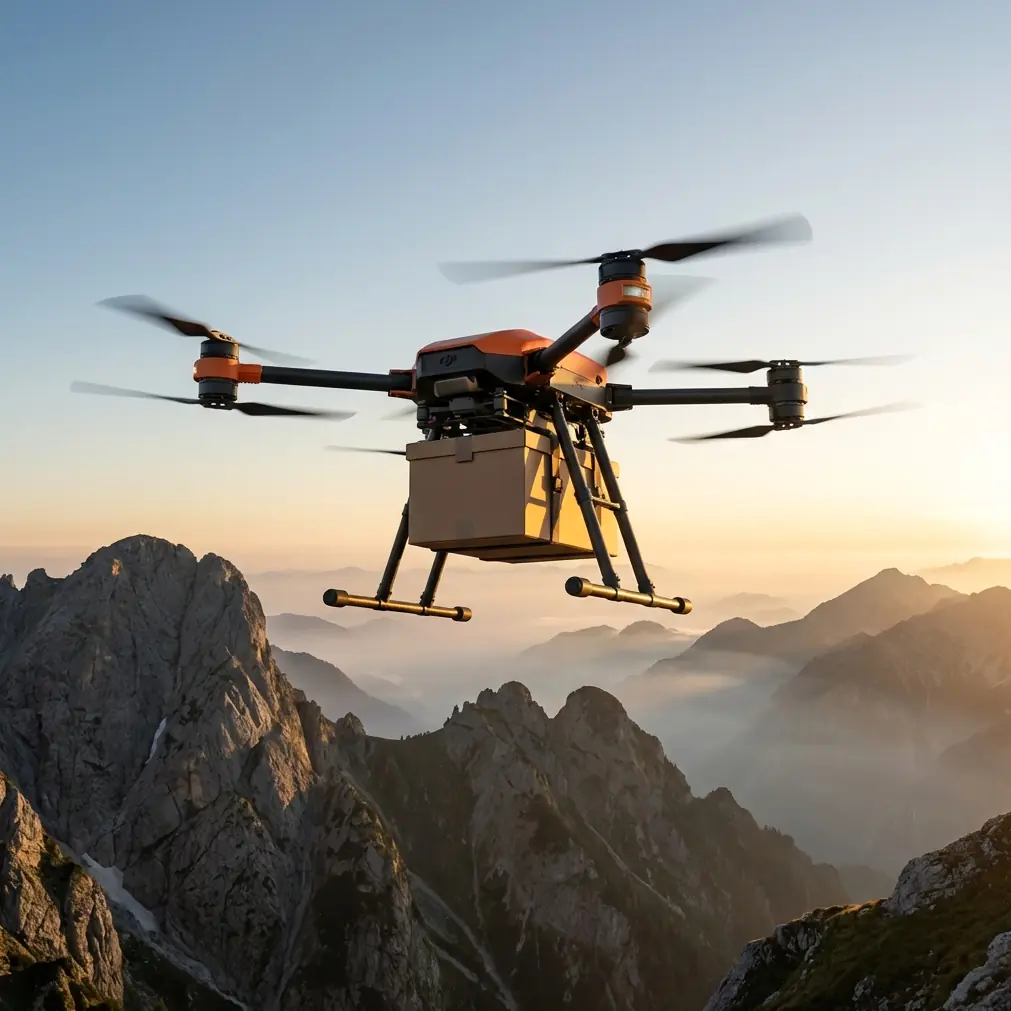
The FlyCart 30’s value in this kind of job is not abstract lifting power. It is the way cargo delivery can be structured into the survey plan.
For us, the winch system was the pivot point.
A coastal venue often lacks clean landing areas. Sand shifts. Grass fields conceal holes. Boardwalk edges create rotor wash concerns. A drone that can lower a load without fully committing to a surface arrival changes site access economics immediately. Instead of forcing every transfer to happen at a secure landing zone, the aircraft can hover over a workable drop position and deliver with more control.
That matters for venue surveys because many “survey points” are not aircraft-friendly. They are operator-friendly. The best visual or measurement location may be near rocks, fencing, temporary structures, or uneven ground. The winch system lets the aircraft serve the team without requiring the terrain to serve the aircraft.
Mid-flight weather shift: the moment that decides whether a platform belongs on your shortlist
The day began with manageable coastal conditions. Then it changed.
About halfway through the second transfer leg, wind direction shifted off the water and gust intensity climbed fast enough that everyone on site noticed at once. Anyone who works around coastal air knows the pattern: the forecast may be technically accurate, but the local expression of it can still surprise you. Air over water behaves differently, terrain edges create their own mischief, and a comfortable route can become untidy in minutes.
This is where drone selection stops being theoretical.
The FlyCart 30 handled the transition the way a working aircraft should. Not dramatically. Not perfectly smooth. Just competently.
The dual-battery design mattered because it preserved mission confidence when the flight profile became less efficient than planned. Coastal gusts can punish your energy assumptions. If your route optimization only works under best-case conditions, it is not really optimized. It is hopeful. With changing wind, available power margin becomes part of risk management, not just endurance math.
The emergency parachute also changed how the team evaluated the platform overall. I’m not talking about flying recklessly because a safety layer exists. The point is that when surveying venues near public-facing zones, access roads, service crews, or temporary event build areas, stakeholders pay attention to contingency architecture. They want to know what happens if the unexpected stacks up. A platform with a clear emergency recovery concept supports planning conversations far beyond the pilot team.
In other words, the aircraft did not just continue the task. It held together the credibility of the operation.
BVLOS thinking begins before you file anything
A lot of people hear BVLOS and immediately think regulation. I think geography first.
The Borås AED network is a useful reference here because emergency dispatch missions depend on route confidence across a service area, not just line-of-sight convenience. Once a region builds out to four bases and reaches around 300,000 residents, the challenge is no longer “can the drone fly?” It becomes “can the operation repeatedly choose good routes under varying conditions?”
That same mindset improved our venue survey workflow.
Even though the site mission itself was limited and controlled, we planned routes as if future recurring operations would need stronger repeatability. We looked at likely transit lanes between the staging area, bluff top, shoreline technical zone, and emergency access corridor. We compared direct path efficiency against wind exposure. We considered where a suspended load would behave best and where route bends would reduce risk near pedestrian approaches.
That is route optimization in the real sense. Not shortest line on a screen. Best line for the actual environment, cargo behavior, and operating margin.
The FlyCart 30 is well suited to this style of planning because it invites operators to treat transport and survey support as one coordinated system. You are not simply flying a camera task and then separately carrying gear. You are building a reusable logistics map of the venue.
Payload ratio is not just a spec sheet talking point
One of the quiet lessons from the Swedish AED network is that useful payloads create useful missions. An AED is not a symbolic item. Its whole value comes from arriving where it is needed, when it is needed, in usable condition.
That principle translates directly to FlyCart 30 deployment in coastal venue work.
Payload ratio matters because the aircraft must carry enough to reduce ground friction without becoming operationally awkward. Too little payload capability and the drone becomes a novelty transport tool. Too much airframe complexity without practical delivery control and the system becomes cumbersome for survey teams.
The sweet spot is when the aircraft can meaningfully reduce manual movement while staying predictable enough to deploy multiple times during a field day.
In our case, that meant moving comms support gear, field batteries, small measurement tools, and site-marking equipment while maintaining a clean operational rhythm. The aircraft did not replace the survey team. It removed the repetitive hauling that wears teams down and distorts timelines.
That is the operational significance of payload ratio. It is not “how much can it lift once.” It is “how much friction can it remove all day.”
What venue operators often overlook
Coastal venue surveys usually focus on visuals, guest circulation, and build zones. Those are obvious priorities. Less obvious is the question of resilience.
If weather turns mid-setup, can equipment be repositioned quickly?
If a team on the far edge of the venue needs a replacement battery, radio, or first-response kit, how long does the transfer take?
If vehicle access is temporarily blocked, what is the backup movement layer?
If the site expands seasonally, can aerial logistics scale with it?
This is where the Borås example remains relevant. A drone network trusted to dispatch in response to emergency calls is built around urgency, routing discipline, and repeatable response. Venue operations are less acute, but they still benefit from the same logic. The best drone-enabled site plans do not merely document a venue. They improve how the venue can function under stress.
That’s why I increasingly view the FlyCart 30 less as a niche cargo aircraft and more as a field operations multiplier for survey-led planning.
A practical note on stakeholder confidence
When we reviewed findings with the venue project team, the conversations were better because the drone had done real work, not just collected pretty footage. We could point to route timings, transfer feasibility, hover-delivery options, and weather-affected decision points. That gave planners something tangible.
They understood, for example, why a controlled winch drop near the bluff access point was better than forcing a landing zone into an awkward patch of uneven ground. They understood why route selection changed once wind came off the water. They saw that safety architecture—especially the emergency parachute—was relevant not only to pilots but to event planners, insurers, and site managers.
If you are building your own coastal venue workflow and want to compare route concepts or payload handling options, it’s often easiest to discuss the site specifics directly on WhatsApp with our drone operations team.
The bigger lesson from Borås
The new Everdrone base in Borås is easy to file away as a healthcare headline. That would miss the point. The real takeaway is that serious drone operations earn trust by solving time-sensitive transport problems across real geography. The fact that Västra Götaland Region now has a fourth E3 base, extending network coverage to roughly 300,000 residents, shows what happens when unmanned delivery becomes operational infrastructure instead of a demo.
For FlyCart 30 users, especially those working in coastal venue surveys, that is the standard worth paying attention to.
Not hype.
Not isolated range claims.
Not ideal-condition footage.
The useful question is whether the aircraft helps you build a repeatable, weather-tolerant, safety-conscious operating method.
In our field case, the answer was yes. The FlyCart 30 proved its value in the unglamorous middle of the job: carrying what mattered, adapting when the wind changed, and letting the survey team evaluate the venue as a functioning logistics environment rather than a pretty map.
That is what makes an aircraft worth bringing back for the next site.
Ready for your own FlyCart 30? Contact our team for expert consultation.