How I’d Use the FlyCart 30 to Survey Venues in Extreme Tempe
How I’d Use the FlyCart 30 to Survey Venues in Extreme Temperatures
META: A practical FlyCart 30 tutorial for surveying venues in extreme heat or cold, with lessons on payload planning, winch workflows, dual-battery endurance, BVLOS routing, and maritime-style recovery thinking.
I’ve had jobs where the venue itself was the problem.
Not because the site was especially large. Not because the route was complicated on paper. The trouble came from the environment: heat bouncing off exposed roofing, cold air draining through open terrain at dawn, gusts funneling between unfinished structures, and no clean place to land near the actual point of interest. In those conditions, conventional survey workflows become clumsy fast. Teams waste time walking gear in, swapping batteries too often, and improvising around unsafe landing zones.
That is where I’d frame the FlyCart 30 differently.
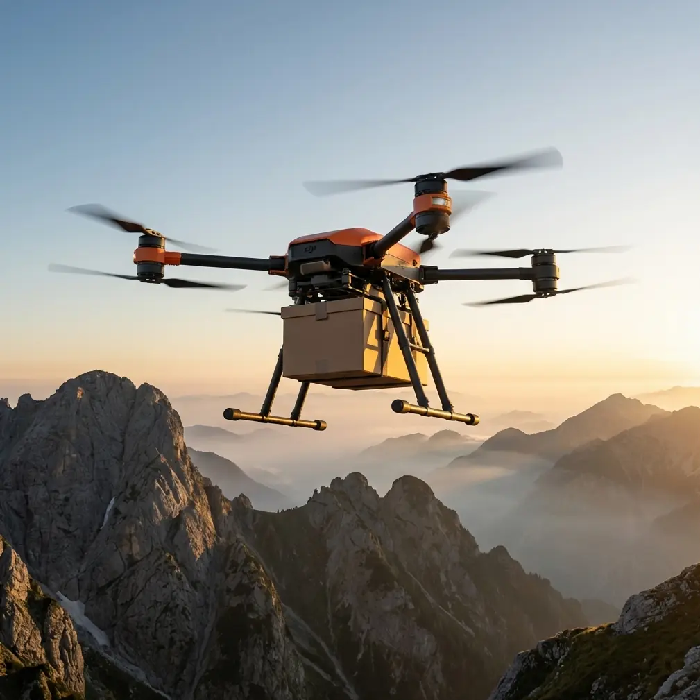
Most people look at the FC30 and think transport first. Fair enough. It is built around payload movement. But when you’re surveying venues in extreme temperatures, payload movement is not separate from data collection. It is the support system that keeps the survey operation moving. If you understand that, the aircraft starts making sense as a field tool rather than just a cargo platform.
This is the method I’d use, based on the kinds of venue problems logistics teams actually face.
Start with the real constraint: not distance, but thermal stress
When teams say a venue is hard to survey, they often mean one of three things:
- The environment punishes battery performance.
- The landing area is inconsistent or unsafe.
- The equipment needed for the survey cannot be moved efficiently to the exact working position.
Extreme temperatures magnify all three.
In severe heat, battery efficiency and onboard temperature margins become part of every mission decision. In severe cold, output stability and flight timing matter even more. Add terrain, temporary event structures, rooftop service areas, waterfront access, or construction-zone restrictions, and the easy answer of “just land closer” disappears.
The FC30 helps because it changes how the payload reaches the survey point. Its value is not only lift. It is controlled delivery.
That matters if you are dropping a compact sensor kit, radio relay, battery cache, calibration target, or inspection package without forcing the drone to touch down in a hostile or unstable zone.
Why the winch system matters more than people admit
For venue survey work, I’d treat the winch system as one of the most operationally significant features on the aircraft.
A lot of site problems come down to the last few meters. You can fly to the venue perimeter, but the survey kit still needs to get onto a rooftop pad, a raised platform, a narrow service corridor, or a fenced section where landing is a bad idea. In extreme heat or cold, hovering over a spot for too long also becomes wasteful. You want a controlled, efficient handoff.
That is where a winch-based workflow earns its keep.
Instead of committing the airframe to a risky touchdown, you hold a stable position and lower the payload. For venue operations, that can mean placing a thermal reference panel, communications node, spare measurement gear, or emergency battery support exactly where the survey crew needs it. The practical benefit is obvious: fewer compromised landings, less rotor wash around sensitive surfaces, and a cleaner chain of custody for the equipment.
I’ve seen teams lose more time dealing with awkward landing access than they ever lose in flight. The FC30’s winch changes that equation.
Payload ratio is not a spec-sheet vanity metric
If I’m planning venue surveys in difficult weather, I care about payload ratio because it dictates how much flexibility I have before the mission gets fragile.
A drone with generous lift margin lets you build a better field package. Not just the primary sensor or delivery item, but the support layers that make survey work reliable: protective casing, thermal shielding for instruments, quick-deploy markers, backup power, and small environmental sensors. In extreme temperatures, these extras stop being optional. They become the difference between a clean survey and a wasted mobilization.
This is one reason the FC30 stands out in practical operations. It allows you to think in systems instead of single items. You are not asking, “Can it carry the sensor?” You are asking, “Can it carry the sensor, protect it from the environment, place it accurately, and preserve enough margin for a safe return?”
That is a better question.
Dual-battery planning is about consistency, not just endurance
People talk about dual-battery setups as if the headline is flight time. For venue survey work, I see it more as a stability advantage.
In extreme-temperature missions, consistency matters. You need predictable power behavior from launch through delivery and return. Dual-battery architecture supports that by giving the operation more resilience and helping smooth the mission profile, especially when the aircraft is carrying useful field gear rather than just demonstrating a maximum-range flight.
Operationally, this changes how I stage a site.
I can pre-position support payloads before the main survey team moves in. I can run a sequence where the aircraft places a relay or kit at one end of the venue, returns, swaps mission configuration, and then supports another zone without redesigning the whole day around one fragile battery window. In cold-weather work, that kind of predictability reduces the pressure to stretch each sortie. In hot-weather work, it limits the temptation to hover longer than necessary over reflective, thermally aggressive surfaces.
That is not glamorous. It is just how reliable fieldwork gets done.
Route optimization becomes critical when the venue is large and thermally uneven
Large venues often create microclimates. Open asphalt can radiate heat. Steel structures can generate turbulence. Shaded lower sections may hold colder air. Waterfront or coastal sites introduce shifting wind profiles. The shortest route is not always the safest or most efficient route.
This is where route optimization matters.
With the FC30, I would not simply draw a straight line from launch to drop point. I’d build corridors that respect the venue’s thermal and airflow behavior. That means using cleaner approach vectors, minimizing loiter time above hot surfaces, and selecting delivery points that reduce unnecessary repositioning on the ground.
If the venue includes maritime or near-water elements, I’d be even more careful about recovery planning. The reason is not theoretical. A recent development from WaiV Robotics shows where the broader industry is heading: a gyro-stabilized platform designed for fully automatic VTOL takeoff and landing on moving vessels, including vessels as small as 10 meters, and intended to work in high sea states. That detail matters beyond maritime transport. It highlights a real operational truth for all field drone teams: recovery is often the hardest part of the mission, especially when the landing environment itself is unstable.
Even though the FlyCart 30 is a different platform and mission type, the lesson carries over. Survey work at waterfront venues, floating event infrastructure, or marine-adjacent industrial spaces should be planned around recovery discipline, not just outbound flight. If the wider market is investing heavily in automatic at-sea landing systems, including a company that just secured 7.5 million in seed funding to commercialize the concept, that tells you operators are prioritizing reliability where conventional landing assumptions break down.
For FC30 venue surveys, I’d apply the same mindset on land: assume the landing zone may become the bottleneck, and build the workflow around alternatives like winch delivery, offset recovery points, and protected staging areas.
A past challenge that changed how I think about this aircraft
One job that stayed with me involved a partially completed venue complex during a bad temperature swing. Early morning cold affected startup routines and timing. By midday, the exposed upper surfaces were hot enough to change how crews moved across the site. We didn’t have one perfect central landing area. We had three inconvenient ones and a lot of walking.
The old workflow was ugly. The survey team waited while support gear was hand-carried. Batteries were consumed on positioning flights that did not produce useful work. Every route change spilled into the next task.
If I had the FC30 on that job, I would have approached it differently.
I would have established a safer launch and recovery area away from the most thermally unstable surfaces, used the aircraft to place support kits by winch near each work zone, and sequenced the survey team’s movement around those drop points. The drone would not replace the survey method. It would remove the friction around it.
That is the right lens for this platform.
BVLOS thinking, even when you are not fully using it
Venue work often sits in a strange middle ground. The site may be compact enough to seem simple, but operationally it behaves like a distributed logistics problem. Separate buildings, fenced sections, access lanes, rooftop zones, temporary structures, and edge-of-site staging areas all slow the team down.
That is why BVLOS-style thinking is useful even when the mission remains within tighter operating limits.
By that I mean disciplined corridor planning, predictable waypoint structure, and treating each support movement as part of a repeatable route network rather than an improvised hop. The FC30 is well suited to that mindset because it is meant to move useful payloads in a structured way. For venue surveys in heat or cold, that translates to less wasted motion and fewer rushed decisions near low-margin conditions.
If your team is trying to build a workflow around this kind of operation, I’d suggest discussing route planning and payload staging with a specialist over WhatsApp here before the site mobilization. A small planning adjustment can save an entire day once temperature and access constraints start stacking up.
Emergency parachute planning is part of professional site culture
This topic does not get enough honest attention.
On challenging venue jobs, especially where crews, contractors, or facility staff are moving around below, risk controls need to be visible in the operating plan. That includes understanding the aircraft’s emergency systems and how they affect your ground layout.
For the FC30, emergency parachute considerations should shape where people stand, where support kits are staged, and which transit lanes remain clear. In extreme temperatures, when environmental stress can compress decision windows, predefined emergency logic matters more than usual. It reduces improvisation. It also improves confidence among clients and site managers who may not be drone experts but understand disciplined safety design when they see it.
A serious operator does not bolt this on at the end. It is part of the site method statement from the start.
A practical tutorial workflow for surveying venues with the FC30
Here is the approach I’d use in the field.
1. Split the mission into survey tasks and support tasks
Do not use the FC30 as if it were the survey sensor itself unless that is truly the plan. More often, it is the support platform that moves the field package, reference tools, batteries, and communications assets.
2. Identify hostile landing zones early
Mark areas where heat shimmer, narrow access, rooftop turbulence, loose debris, or poor footing make landing a bad choice. Assume at least one primary landing option will become unusable during the workday.
3. Build the payload package around temperature protection
Think beyond the main instrument. Include insulation, shielding, secure rigging, and quick-access packaging so the ground team is not exposed longer than necessary when retrieving the load.
4. Use the winch for precision placement
If the venue has awkward roof edges, service bays, fenced compounds, or marine-adjacent sections, lower the package instead of forcing a touchdown.
5. Stage around dual-battery consistency
Plan sorties for repeatability, not maximum stretch. In extreme temperatures, predictable shorter cycles usually outperform aggressive single-cycle plans.
6. Optimize routes by environment, not geometry
Avoid the temptation to fly the mathematically shortest path if it crosses the venue’s worst thermal or wind behavior.
7. Keep recovery separate from delivery logic
Delivery success does not mean mission success. As maritime operators are now demonstrating with automatic recovery systems for moving vessels, the hardest part can be getting the aircraft back safely when the platform below is unstable. Treat your venue recovery plan with the same seriousness.
Why this matters now
The bigger story is not just about one aircraft. It is about where commercial drone operations are maturing.
The WaiV Robotics launch is a strong example. A company does not build a fully automatic, gyro-stabilized sea landing platform for VTOL drones on vessels as small as 10 meters unless customers are demanding reliability in places where ordinary landing assumptions fail. Venue survey teams face a version of that same challenge every day, just on different surfaces and in different weather.
The FlyCart 30 fits that shift well.
Its value in venue surveying is not that it makes the site look futuristic. Its value is that it reduces the penalties of bad access, harsh temperatures, and awkward recovery conditions. It helps the survey team spend more time gathering useful information and less time fighting the environment.
That is the kind of productivity gain professionals actually care about.
Ready for your own FlyCart 30? Contact our team for expert consultation.