FlyCart 30 Field Report for Mountain Vineyard Survey Work
FlyCart 30 Field Report for Mountain Vineyard Survey Work
META: A field-focused FlyCart 30 article for mountain vineyard operations, covering altitude planning, route logic, winch workflows, dual-battery resilience, and why disciplined configuration control matters after any airframe change.
Mountain vineyards expose every weakness in an aircraft program. Slopes distort your sense of height. Valleys create dead spots in signal planning. Loading zones are rarely flat. Wind can be mild at the takeoff point and unruly a few terraces higher. If a team wants to use the FlyCart 30 around this kind of terrain, the question is not simply whether the aircraft can fly there. The real question is whether the operation can stay organized as the aircraft, mission kit, and procedures start changing in response to field reality.
That is where this discussion gets practical.
Most articles about the FlyCart 30 stay at the level of specifications or broad use cases. For mountain vineyard survey support, that misses the harder issue. The challenge is system discipline: how you manage route design, payload handling, altitude decisions, and any hardware or procedure changes without turning a useful platform into a source of inconsistency. A single page from an aircraft design manual, page 326, says more about long-term FlyCart 30 success than many glossy summaries ever will. Its subject is configuration modification workflow, and while it comes from manned aircraft design practice, the logic translates cleanly to serious commercial UAV operations.
For a logistics lead like me, that matters because vineyards in mountainous areas force adaptation. The temptation is to “just tweak” the aircraft setup after a difficult day in the field. Maybe the winch line length needs adjustment. Maybe the payload interface should be changed for sensor drop points. Maybe the emergency parachute mounting position seems worth revisiting. Maybe the route profile used for one valley should become the standard for the next one. Those changes sound small. Operationally, they are not.
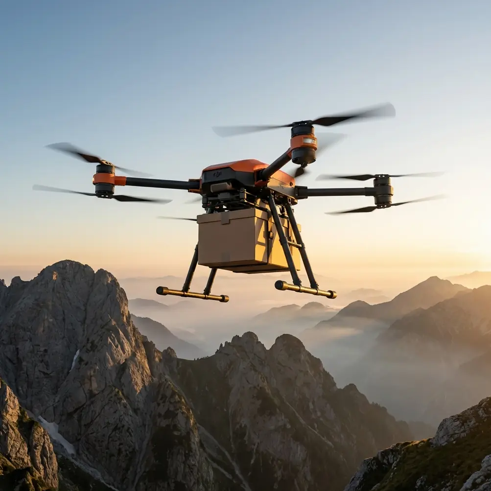
Why a mountain vineyard mission pushes the FlyCart 30 harder than flatland work
Survey support in vineyards is rarely a pure mapping sortie. It often combines observation, equipment transfer, battery staging, marker placement, or moving lightweight tools between terraces where trucks and crews lose time. That is why the FlyCart 30 is attractive in the first place. It is not just a camera carrier. Its payload ratio and winch system make it useful when the survey mission overlaps with logistics.
In mountain terrain, that flexibility becomes a strength only if altitude discipline is strong.
My preferred starting point for this scenario is simple: fly by relative terrain logic, not by an emotional preference for “higher is safer.” Over vineyards on stepped slopes, a working altitude band around 25 to 40 meters above the local canopy or terrace reference is often the sweet spot for support passes, visual terrain reading, and controlled winch placement. Go much lower and rotor wash becomes a practical nuisance near vines, stakes, and netting. Go much higher and you begin to lose precision in drop alignment, visual confirmation of terrace obstacles, and the efficiency gains you were trying to unlock in the first place.
That is not a universal prescription. It is an operational insight. In steeper sections with uneven ridges and sharply rising contour lines, I would rather see the aircraft hold a stable terrain-following profile than chase a fixed home-point altitude that means very different things at the bottom and top of the block. For FlyCart 30 teams working around vineyards, that one shift in mindset usually improves mission consistency immediately.
The hidden value of the winch system in vineyard survey support
Mountain vineyards create one recurring problem: there may be no safe landing area where the item actually needs to go. That is where the winch system matters more than people expect.
In flat agricultural work, operators often think of payload movement as a pickup-and-drop task. In vineyards built into slopes, the mission is usually “deliver without committing the aircraft to the terrain.” The winch reduces the need to descend into awkward rotor environments near trellis wires, posts, workers, and uneven ground. For survey support, that can mean lowering a compact instrument case, field batteries, sample containers, or temporary markers onto a terrace while the aircraft remains above the clutter layer.
This is also where route optimization becomes more than software housekeeping. If the FlyCart 30 is being used across several terrace levels, you do not optimize only for shortest path. You optimize for repeated vertical geometry. Routes that minimize aggressive descent and climb cycles tend to improve both energy stability and placement consistency. In practice, I often prefer a route that traces the contour and approaches each drop from a predictable lateral angle, even if the total distance is slightly longer. Mountain missions punish vertical inefficiency far more than operators assume.
Dual-battery thinking in the real world
Dual-battery architecture tends to get treated as a reassurance feature. For me, in mountain vineyard work, it is a planning tool.
When you are moving along slopes where return paths can be lengthened by terrain, wind channels, or a need to climb out of a ravine-like row system, power margins stop being abstract. A dual-battery setup supports resilience, but only if the crew uses it to shape decisions early. That means conservative reserve policy, not optimistic dispatch. It means accounting for the fact that a mission ending uphill is not equivalent to a mission ending downslope. It also means watching how payload ratio influences climb behavior on a warm afternoon when density altitude starts stealing performance.
The FlyCart 30 can be very capable here, but the trap is assuming that capability erases terrain penalties. It does not. In vineyards, the battery conversation should always include three questions: where is the aircraft likely to be when the reserve threshold is reached, what climb is still ahead, and how much route flexibility remains if the original landing terrace becomes unusable?
Those are not dramatic questions. They are ordinary field questions. That is exactly why they prevent incidents.
BVLOS and route logic: where mountain work becomes a systems problem
Some mountain vineyard properties are long enough or segmented enough that teams naturally start thinking about BVLOS operations. Whether that is viable depends on local rules, approvals, crew structure, communications planning, and the maturity of the operator. But even when the mission stays within visual limits, BVLOS-style route discipline is useful.
Why? Because vineyard terrain creates partial occlusion. You may technically be close to the aircraft and still be working with compromised situational clarity due to ridges, tree lines, service structures, or variable terrace elevation. So the route should be designed as though predictability is a feature in itself.
That means:
- repeatable approach directions,
- clear trigger points for aborts,
- predefined alternates for hover and recovery,
- and a hard distinction between experimental routing and approved routing.
This last point connects directly to the reference material.
What an aircraft design manual teaches FlyCart 30 operators about change control
The source page lays out a formal modification workflow: a change request, preliminary review, a more detailed proposal, approval to launch the change, creation of detailed modification documents, formal authorization, execution, and then acceptance and verification. It also says that a modification request should state the name of the change, the main reason, the affected area, the principal content, the scope, the applicable batches, the expected cycle, the expected cost, the responsible department, and the technical documents involved.
For a commercial UAV team, that list is pure gold.
Think about how often operators alter a payload bracket, switch a winch interface, relocate a mounting point, revise a battery handling procedure, or change route templates after a rough week in the field. Most of these changes happen informally. Someone decides the old method was inefficient. Someone else says the new setup worked yesterday. Before long, two crews are flying the “same” FlyCart 30 with different assumptions.
That is how drift begins.
The manual also distinguishes a simpler path for modifications made before the overall technical state is frozen. In other words, early in development, change is easier because the system definition is still fluid. Once the baseline hardens, changes have wider consequences. For FlyCart 30 operators, the operational significance is obvious: your pilot program phase is the time to test and refine. Once the mountain vineyard workflow is standardized, every adjustment should be treated more seriously because it may affect training, maintenance, route planning, payload safety, and documentation.
That is not bureaucracy for its own sake. It is the reason a fleet remains predictable.
A better way to handle FlyCart 30 adaptations in the vineyard
If I were standing up a FlyCart 30 program for mountain survey support, I would borrow the spirit of page 326 and build a lightweight configuration board, even if the “board” is just three people: operations, maintenance, and safety.
Every change would need a one-page record covering:
- what is changing,
- why it is changing,
- which aircraft or mission profiles it affects,
- what documents need revision,
- what validation flight is required,
- and who signs off.
That mirrors the source in a practical way. It also addresses another key detail from the manual: when configuration changes affect technical state, all relevant technical documents should be revised. In UAV terms, that includes checklists, maintenance notes, payload handling instructions, route libraries, emergency procedures, and training syllabi. If your FlyCart 30 winch procedure changed but your field checklist did not, the operation is already split between paper and practice.
The source also emphasizes acceptance and verification by a quality function. That deserves more respect in drone operations. After a field modification, do not rely on “it flew fine.” Verify. Run a defined acceptance flight. Test the new route profile. Confirm the emergency parachute is not affected by the payload change. Check that the dual-battery swap sequence still works smoothly under slope-side pressure. Watch line behavior on the winch with the revised approach altitude. Then write down the result.
That is how you keep improvement from degrading reliability.
Emergency parachute considerations in steep agricultural terrain
The emergency parachute is often discussed as a safety endpoint. In mountain vineyards, it should be considered earlier in planning than most teams do.
Terraced agriculture compresses available ground options. A parachute system may improve outcomes in a severe failure scenario, but the surrounding terrain still determines what “improved” means. Vines, wires, access roads, workers, retaining walls, and slope angles all shape the actual risk picture. So if an operator changes payload geometry, center-of-mass behavior, or flight corridor design, those decisions should be reviewed not only for ordinary performance but also for their interaction with emergency descent outcomes.
This is another place where disciplined modification control matters. A mounting change that looks harmless during normal flight may influence emergency system behavior, post-event landing distribution, or snag risk in agricultural infrastructure. That is exactly the type of downstream effect a formal review process is designed to catch.
The field lesson that keeps paying off
Here is the blunt version.
The FlyCart 30 is useful in mountain vineyards not because it can do everything, but because it can do a narrow set of hard tasks repeatedly when the operator stays disciplined. The most valuable habit is not aggressive route experimentation. It is controlled standardization.
Pick an altitude philosophy that respects local terrain. For most vineyard support work, starting around 25 to 40 meters above local working surface is sensible, then adjusting block by block. Use the winch to avoid unnecessary descents into clutter. Treat dual-battery capacity as a decision framework, not a comfort blanket. Build routes around contour logic rather than straight-line temptation. If a BVLOS pathway is being considered, design for predictability well before regulatory approval enters the picture.
And every time the team changes something meaningful, handle it like a real aircraft organization would.
If your operation is refining FlyCart 30 procedures for steep agricultural sites and you want to compare notes on route structure or payload workflow, you can message our field team directly.
That might sound formal for drone work. Good. Mountain terrain rewards formal thinking. Vineyards only look gentle from a distance.
Ready for your own FlyCart 30? Contact our team for expert consultation.