How I’d Approach High-Altitude Wildlife Surveying
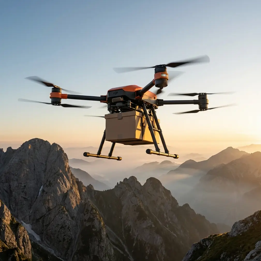
How I’d Approach High-Altitude Wildlife Surveying with the FlyCart 30
META: A field-focused look at using the DJI FlyCart 30 for high-altitude wildlife survey support, with practical notes on payload ratio, winch use, BVLOS planning, dual-battery reliability, parachute safety, and a critical pre-flight cleaning step.
High-altitude wildlife work exposes every weak point in an operation.
Thin air cuts into lift. Mountain weather shifts faster than most teams can react. Launch sites are rarely ideal. And the farther you move from roads or established camps, the more every kilogram, every battery decision, and every route plan starts to matter. That is why the FlyCart 30 is interesting in this context—not because wildlife surveying suddenly turns into logistics, but because survey success in remote terrain often depends on logistics done well.
I say that as someone who thinks about field execution first. If you are supporting wildlife teams above the tree line, the aircraft is not just a transport tool. It becomes a bridge between inaccessible observation points, power constraints, weather windows, and crew safety. The FlyCart 30 sits in that gap.
But using it well for wildlife survey support requires discipline. The headline specs matter less than the operating logic behind them.
The real problem in high-altitude wildlife surveys
People often talk about drones in wildlife work as if the mission is only about getting airborne and collecting imagery. In reality, the hardest part is keeping the team supplied and mobile without disturbing habitat or burning out personnel.
A survey team working at altitude usually has to solve several problems at once:
- move batteries, optics, radios, and field sensors into rough terrain
- support repeated flights or observation sessions from temporary positions
- reduce foot traffic through sensitive wildlife corridors
- maintain safe operations under changing wind and temperature conditions
- preserve enough reserve capacity to handle an aborted landing or route change
This is where the FlyCart 30 can be valuable. Not because it replaces all field movement, but because it can reduce the number of risky, time-consuming manual carries into exposed areas.
That matters operationally. If a team can stage equipment at elevation with fewer human trips, they spend less time fatigued, less time crossing unstable ground, and less time disturbing the same habitat they are trying to monitor.
Why payload ratio matters more than raw lift
One of the most overlooked ideas in field drone operations is payload ratio.
Most operators focus on the maximum carrying figure. That is understandable, but in wildlife survey support the more useful question is this: how much of the aircraft’s total effort is going into useful mission equipment versus energy overhead and contingency margin?
At high altitude, payload ratio becomes a planning tool, not just a spec-sheet talking point.
If you load the FlyCart 30 too aggressively, especially in thin air and variable winds, you narrow your options. Route flexibility drops. Diversion capability shrinks. Landing choices become less forgiving. That can be acceptable in a controlled industrial transfer. It is not ideal in mountain survey work where terrain and weather can change inside a single sortie.
A balanced payload ratio gives you room for smarter route optimization. It allows the aircraft to reach a staging point, hold enough reserve for a safer return profile, and avoid pushing battery systems into the least forgiving part of the curve. For wildlife operations, that usually means carrying what the field team actually needs that day—not everything they might possibly use.
The best FC30 missions I would plan for altitude are not the heaviest ones. They are the cleanest ones. Lean loadout. Clear route. Defined handoff. Predictable turnaround.
The winch system changes how supplies reach difficult ground
For high-altitude wildlife support, the winch system is not a convenience feature. It is one of the most operationally relevant parts of the platform.
There are many sites where landing is the wrong choice. Rocky ridgelines, narrow clearings, snow patches, unstable scree, or areas where rotor wash could disturb animals all create unnecessary exposure if you insist on touchdown delivery. A winch allows the aircraft to remain in a more controlled hover while lowering equipment to a team positioned below.
That changes mission design.
Instead of searching for a safe landing zone close to the observers, you can identify a safer hover point and conduct a controlled drop-off without forcing the aircraft into terrain it should not be touching. For wildlife teams, this also reduces the need to clear or trample a landing area in ecologically sensitive locations.
The significance is practical. Binocular cases, camera batteries, sensor modules, medical packs, and lightweight shelter items can be delivered with less surface disturbance. If the site is windy or uneven, the difference between landing and winch deployment can be the difference between a routine handoff and a damaged aircraft.
That is also where crew training matters. A winch mission is only smooth if the receiving team knows how to secure the area, approach the suspended load correctly, and avoid creating pendulum movement. The aircraft feature helps, but the workflow is what makes it useful.
BVLOS is not just range—it is operational discipline
When people hear BVLOS, they often think only about distance. In mountainous wildlife surveying, that is too simplistic.
BVLOS matters because terrain blocks direct access and visual continuity. Your survey support aircraft may need to move supplies between points separated by ridges, valleys, or protected habitat where a straight-line foot approach would be inefficient or disruptive. In that environment, BVLOS capability is meaningful only if route planning, communications, and contingency procedures are equally mature.
For the FlyCart 30, BVLOS-style operations should be framed around predictability:
- route segmentation by terrain exposure
- pre-identified emergency holding or abort zones
- battery thresholds adjusted for elevation and wind
- communication routines between remote observers and the flight crew
- strict launch and recovery criteria that account for mountain weather variability
This is where route optimization becomes more than software. It becomes ecological and operational restraint. The most efficient route is not always the shortest line. Sometimes the right path is the one that avoids nesting zones, minimizes rotor presence near animal movement corridors, or maintains better signal and terrain clearance even if it adds distance.
That kind of thinking is what separates a successful survey support mission from a technically completed but poorly designed one.
The pre-flight cleaning step I would never skip
There is one habit I would insist on before any high-altitude FC30 wildlife mission: clean and inspect the safety-critical interfaces before launch.
This sounds basic. It is not.
Mountain operations expose the aircraft to dust, fine grit, pollen, moisture residue, ice crystals, and transport debris. Those contaminants can interfere with moving parts, latches, venting, and sensor surfaces in ways that may not be obvious during a rushed deployment. If your aircraft includes safety systems such as an emergency parachute, there is no room for casual assumptions. The housing, release pathway, and surrounding surfaces need to be clean, unobstructed, and visually confirmed.
The same mindset applies to battery contacts, connector points, winch attachment hardware, landing gear areas, and any exposed sensing surfaces used for navigation or system health checks.
I like to think of this as the drone equivalent of clearing the frame before taking the shot. One reference I was given described how a black-background flower image can be created in about 20 seconds by controlling camera parameters so the flower stands out while the background falls away. There is a useful operational parallel here. In field aviation, clean preparation does the same thing. It strips away interference so the mission-critical element can do its job.
That source also emphasized doing more with less—no specialized equipment, no complex post-processing, fast execution. Again, that thinking translates surprisingly well. A disciplined 20-second cleaning and visual check of the parachute area, payload hook, battery mating surfaces, and sensors can prevent the kind of small contamination issue that turns into a large field problem later. You do not need a complicated ritual. You need a repeatable one.
In remote wildlife work, that kind of simplicity is valuable because crews are often cold, tired, and moving quickly. Short checklists survive real conditions better than elaborate ones no one follows.
Why the dual-battery setup matters in the mountains
Dual-battery architecture is especially relevant at altitude because environmental stress compounds quickly.
Cold temperatures reduce battery efficiency. Climbing to higher elevations increases power demand. Wind along ridgelines can force throttle corrections that are far from smooth. In those conditions, energy resilience is not a luxury. It is part of your risk model.
A dual-battery arrangement helps in two ways.
First, it supports practical endurance and load management, giving operators more flexibility in how they stage missions. Second, it adds a layer of operational confidence when conditions are less stable than forecast. That does not mean teams should relax their margins. It means the aircraft is better aligned with the realities of mountain work, where reserve planning must be taken seriously.
For wildlife survey support, this matters because mission failure is not only about the aircraft. A missed battery resupply can cancel an observation window. A delayed sensor delivery can waste a day of animal movement tracking. Energy reliability has ripple effects across the whole field team.
Emergency parachute: not a headline feature, a route-design factor
The emergency parachute should influence how you plan, not just how you market the aircraft.
In high-altitude terrain, every route crosses areas with different recovery consequences. A system-level emergency measure does not erase risk, but it changes how you think about acceptable exposure. When I map routes for support flights, I want to know where an unexpected failure would create the least harm to people, equipment, and habitat. The presence of an emergency parachute supports that planning framework, especially when operating in places where forced landing options are limited.
This is another reason the earlier cleaning step matters. Safety systems only help when they are protected from neglect.
If your team is building a serious FC30 workflow for wildlife programs, treat the parachute as part of mission engineering. Confirm status. Keep the deployment area clean. Build route segments that respect terrain and overflight sensitivity. Do not leave this in the category of “nice to have.”
Building a better workflow for wildlife teams
A strong FlyCart 30 wildlife support operation is usually quiet and uneventful. That is the goal.
You are not trying to create dramatic flights. You are trying to build a system that helps biologists and survey crews stay focused on animals, habitat, and data quality rather than on whether gear will arrive where it is needed.
A practical workflow might look like this:
- Define the field objective first. Is the team supporting camera trap deployment, observation post resupply, acoustic monitoring, or thermal survey staging?
- Set a strict payload ratio target. Carry the day’s essentials, not the full inventory.
- Use route optimization around terrain and habitat sensitivity. Avoid obvious disturbance paths even if they look shorter.
- Choose winch delivery when landing increases risk or environmental footprint.
- Run a short but serious pre-flight cleaning and inspection. Prioritize the emergency parachute area, battery contacts, hooks, latches, and sensors.
- Plan around dual-battery reality, not wishful endurance. Keep reserve margins honest.
- Coordinate BVLOS communication routines with the remote team. Every handoff point should be confirmed before takeoff.
That is how the FC30 becomes useful in wildlife surveying. Not as a generic heavy-lift drone, but as a disciplined field support platform.
The larger lesson from the source material
At first glance, a phone photography tip about black-background flowers seems unrelated to a transport UAV. But the core idea is surprisingly relevant: control the variables that matter, suppress the noise that gets in the way, and get the result efficiently.
The source described using camera settings to isolate the flower and darken a distracting background, with the process taking roughly 20 seconds and no need for special equipment or complicated editing. In mountain drone work, the same philosophy can improve outcomes. Tight procedures beat clutter. Quick, repeatable checks beat long theoretical manuals. Small adjustments in preparation can dramatically improve the quality of the end result.
For the FlyCart 30 in high-altitude wildlife surveying, the mission is not just to move payload. It is to reduce friction across the whole operation—fewer unnecessary foot movements, fewer unsafe landings, fewer energy surprises, fewer preventable safety oversights.
If your team is building that kind of workflow and wants to compare field setups or handoff procedures, you can share your mission profile here: message our flight support desk.
The FlyCart 30 makes the most sense when it is used with restraint, not bravado. Respect the mountain. Respect the habitat. Keep the payload honest. Clean the aircraft before every sortie. Let the systems do the work they were designed to do.
Ready for your own FlyCart 30? Contact our team for expert consultation.